The Tilley's of the New Forest
Lets start our story with John Tilley born in the 1600's in the New Forest.
This is the earliest Tilley I have found in this branch of my Family Tree.
From here we can explore how his descendants have moved from a small village in Hampshire, England, around the world.
Article restructured in Feb 2022 to aid readability. Part of this was done with articles within articles.
Click to see a heat map of the Sopley One Place Study, which was commenced to aid this story, and resolve some of the Tilley's mysteries.

Zooming in to the hottest part of the heat map, Great Britian.
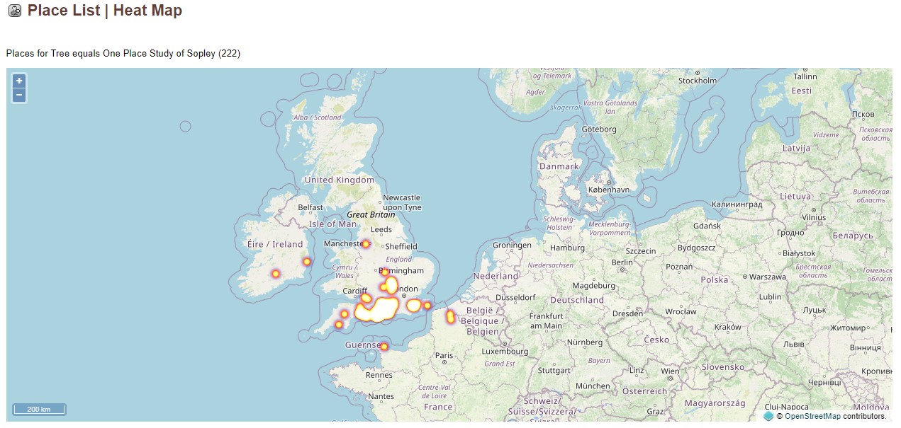
Click to see the latest version of this heat map of the Sopley One Place Study, how it has progressed from February 2022 when the above screenshots were taken.
Pick a centaury and read about the Tilley's and the history around them. When there are tabs, it works as all the way to the bottom, including additional tabs, before going right to the next tab. Down, then across.
Location
Brief History of Hampshire
During the period of Anglo-Saxon settlement, modern Hampshire and the Isle of Wight were occupied by Jutish tribes – a people separate initially from the Saxons and Angles. Jutes founded kingdoms known as Wihtwara (Wight), Meonwara (Meon Valley) and Ytene (in an area similar to the later site of the New Forest). According to St Bede, however, the Jutes were conquered by the surrounding Saxon kingdoms during the 7th Century. Hamtunscīr (after Hamtun, the original name of Southampton) was one of the first Saxon shires to be recorded, in 755.
For two centuries Hampshire represented the western frontier of Saxon England, as the Britons fought off advances into Dorset and Somerset. After the Saxons advanced west Hampshire became the centre of the Kingdom of Wessex, and many Saxon kings are buried at Winchester. A statue in Winchester celebrates the powerful King Alfred, who stabilised the region in the 9th century.
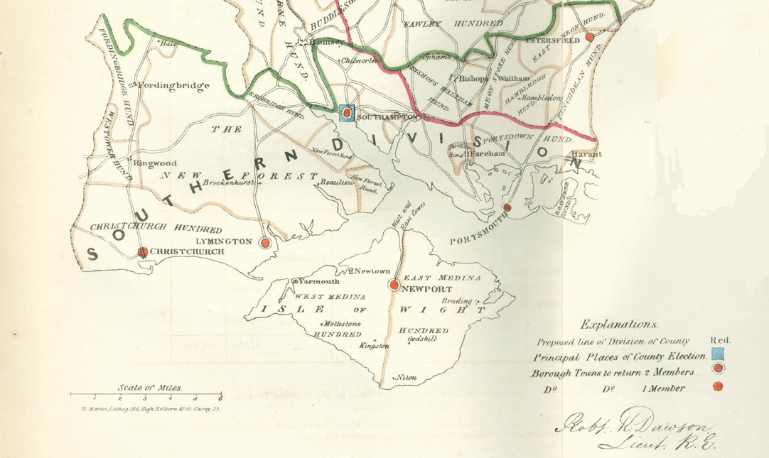
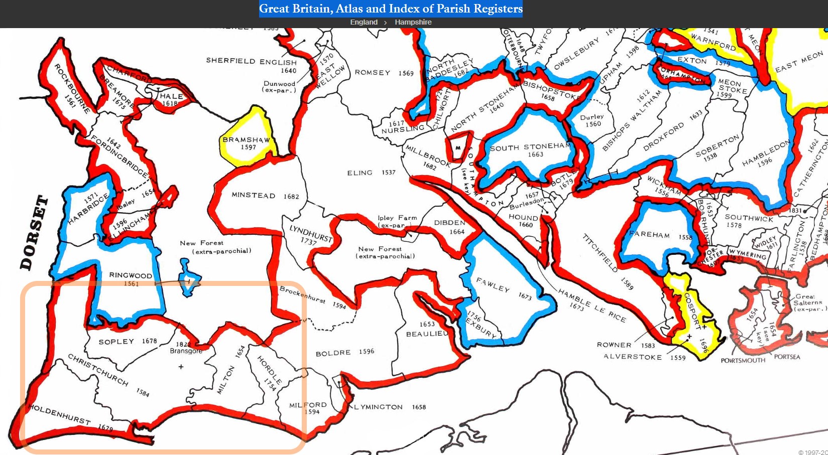
After the Norman Conquest the county was favoured by Norman kings who established the New Forest as a hunting forest. The county was recorded in the Domesday Book divided into 44 hundreds. These later consolidated to 37. These were Alton, Andover, Barmanstip, Barton Stacy, Basingstoke, Bedbridge, Bondsborough, Bosmere, Buddlesgate, Christchurch, Chutely, Crondall, East Meon, Evinger, Fawley, Finchdean, Fordingbridge, Hambledon, Heling, Holdsett, King's Somborne, Kingsclear, Mansbridge, Meanstoke, Micheldever, New Forest, Odiham, Overton, Pastrow, Portsdown, Ringwood, Shelbourn, Sutton, Thorngate, Titchfield, Waltham and Wherwell. Sopley was in the Christchurch Hundred from this 1832 Boundary Map. Another useful Boundary Map updated up to 11/12/1899 is found here, zoom in to find Christchurch, and then Sopley.
Sopley

Sopley, Hampshire
Introduction
It is the subject of my One Place Study of Sopley.
Follow this link to jump drectly to my The Next Generation (TNG) database.
Ten generations ago, John Tilley was born in or nearby the small hamlet of Sopley, Hampshire, England, and the year was 1665. John, and his place in our Family Tree, was the catalyst for the article 'The Tilley Family Migration' and subsequently this article and One Place Study of Sopley held in TNG.
Sopley is an ancient settlement going back to before the Doomsday book and is described in this article. It is on the edge of the New Forest. The nearby area is sometimes in Hampshire and sometimes in Dorset depending on various boundary changes. Most of the employment in the area would have been engaged in either rural activities or supporting the large number of family estates in the area. Sopley Park and Winkton House being a couple of the closest.
A couple of centuries later and Sopley is still a rural community as seen on this 1872 Ordnance Survey Map. More information on Sopley can be found on Vision of Britain and British History Online. Sopley was in the Christchurch Hundred from this 1832 Boundary Map. Another useful Boundary Map updated up to 11/12/1899 is found here, zoom in to find Christchurch, and then Sopley. From the Vision of Britain Through Time analysis 70% of Sopley families are engaged in Agriculture from the 1831 Census data. Another map even earlier, 1640, which includes Sopley and the adjacent Avon, both in the Hundred of Christchurch, is held by the British Library, entitled Hantonia, sive Southantonensis Comitatus, vulgo Hantshire. Only slightly earlier, in the Hampshire from Pieter Van den Keere's miniature County Atlas of the British Isles of 1605-10 Avon, albiet spelt Auen, is shown but Sopley is not. Similarily on the SOUTHAMPTONIAE Comitatus by Christopher Saxton, dating from 1575. Read more about Introducing medieval maps | British Library - Picturing Places.
Digging further back in time takes us to feudal Britain just after 1066. That leads to Richard de Redvers, the 1st feudal baron of Plympton in Devon.
Sopley is part of the 'Hundred of Christchurch', which in turn is part of the 'The honour of Christchurch'. Richard de Redvers, after acting as one of the principal supporters of Henry I in his struggle against his brother Robert Curthose for control of the English throne, was rewarded with estates that made him one of the richest magnates in the country. After the grants from the king, Richard's Devon estates probably consisted of around 180 Domesday manors, including Tiverton and Honiton, as well as the boroughs of Exeter and Plympton. He held the honour of Christchurch which consisted of many widely scattered manors in several counties. He held virtually all of the Isle of Wight (the exceptions being two manors held by the bishop of Winchester), and the island remained in his family until King Edward I bought it from a dying Isabella de Fortibus in 1293. His son became the 1st Earl of Devon. Just because the Earl of Devon held Sopley in his collection of lands does not mean that he ever lived there or even visited. It is though Plympton, Exeter, and Carisbrooke Castle are more likely residences. It is fascinating to learn something of the lives of people in such a distant time.
Even the name Christchurch has an interesting history according the caption on a drawing of Christchurch Priory held by the British Library
A church has stood on this site (Christchurch Priory) since Saxon times when the town was originally called Thuinam or Twynham. In 1094 Ranulf Flambard, a minister of William II, began to build his church here. In 1099 he was appointed to the Bishopric at Durham, but building of the priory continued. It was during this time that the town and priory changed its name from Twynham to Christchurch. As workmen were constructing the roof, a mysterious carpenter appeared one day to assist them. One evening a beam put in place was found to be too short. The next morning the beam had "grown" to the proper length and the mysterious carpenter was not to be seen again. They assumed that Christ himself had come down from heaven to help build his own church and the church was thus renamed Christ's Church of Twynham, and later Christchurch.
Frequently it is random wandering around a subject which leads to little gems. The investigation around the One Place Study of Sopley may provide both probable and improbable names. Both are as important. As Sopley is an ancient settlement with associations to aristocracy and royalty, who knows where this trail might lead us.
Maps
Received a parcel from National Archives this morning. Some books that I had ordered and a DVD of the Atlas of Counties of England form Actual Surveys made from the Years 1817 to 1833 by C&J Greenwood. Read the instructions and then opened the maps, but there was no Hampshire in the H's. Ah, wait a minute, Southampton. Yes there it was. They are beautiful looking maps and the instructions include how to copy them, so here are a few images.
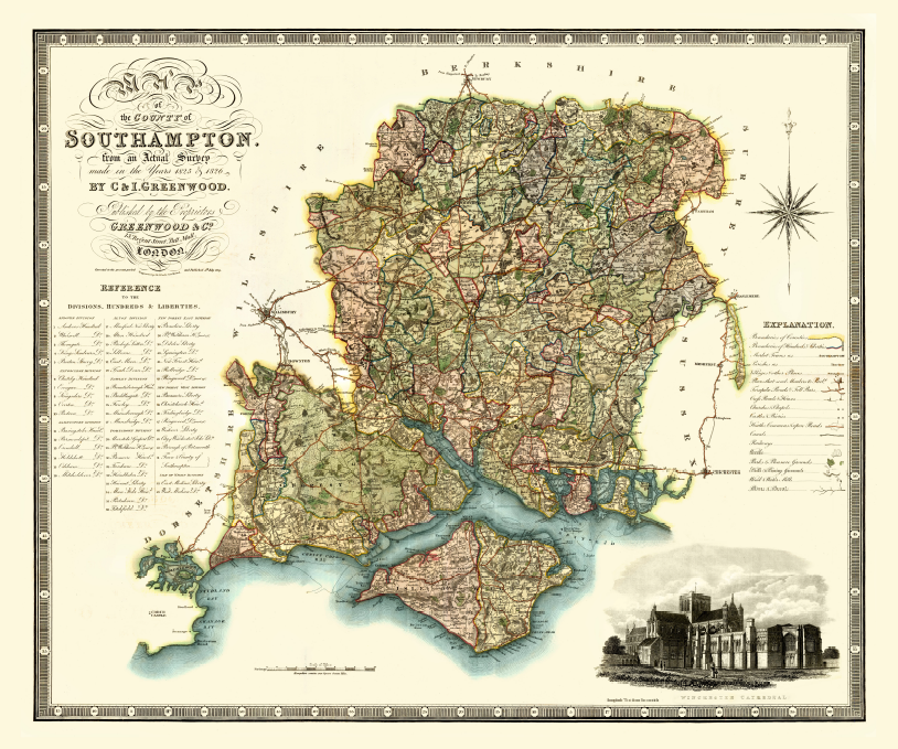
Just look at the workmanship in the title block alone!
There are file size limitations which stop me from making this zoomable so that you can really see the amount of detail across the whole map. However, if you hover over the map of the whole County of Southampton (Hampshire) {Not to be confused with the County Borough of Southampton} it will miraculously zoom into the New Forest area.
On the left side of the map there is the 'Reference ot the Divisions, Hundreds and Liberties'. The zoomed in map shows the list for the New Forest West Division, The Hundreds and Liberties, including the 45, Christchurch Hundred, of which Sopley is a part. The full list of the Division is hidden under the Title image.
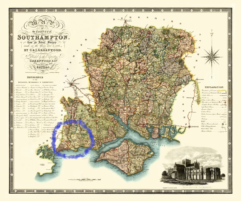
The next map I have defaced with crayon just to show you where Sopley is. Don't worry though, it is only digital crayon. Sopley is beside the New Forest, to the West, near Christchurch, which at the time had not been redesignated as being in Dorset. This time, when you roll the mouse over it zooms into Sopley and Ripley, and the nearby area.
Below is an extract of the introduction to Greenwood's Atlas.
Christopher Greenwood, was born on 21 May 1786 in Gisburn, Yorkshire, an area where the family had lived for some considerable time, he was the third of ten children. Christopher learned to be a surveyor and presumably practiced locally. At the age of 29 he set up a practice in Dewsbury and in 1816 he moved to Wakefield and commenced a survey of his native county, Yorkshire. This map of Yorkshire was published in 1817 in Wakefield. The map was at a scale of about three quarters of an inch to one mile and was published on nine sheets twenty seven by twenty three inches. The map was based on the Board of Ordnance’s principal triangulation, published in 1811, but local triangulation was the work of Greenwoods surveyors. The Board of Ordnance, later to become the Ordnance Survey, started to publish maps at one inch scale in 1805 but progressed very slowly and did not complete the series for England and Wales until 1865. Greenwood’s intention was to make his maps available more quickly.
In 1818, with only the Yorkshire map in print, he moved his business to London and started on his objective of producing maps of all the remaining counties of England at a scale of one inch to one mile plus Wales at three quarters of an inch to one mile. In 1922, with eleven maps completed, he advertised his scheme to produce a set of forty two maps to be sold for 135 guineas. The scheme was never completed, six counties of England and most of Wales were never produced. He was not the only private map maker with this objective, the most notable of his competitors was Andrew Bryant who produced maps of 13 counties. The only person who completed this task was fellow Yorkshireman Christopher Saxton in the 1570s (coincidently Saxton also started his work based in Dewsbury).
For a more popular appeal Greenwood reproduced the maps at a reduced scale of three miles to one inch as an Atlas. This was produced in parts over a period from 1829 to 1834.
At about the same time as Greenwood was surveying and creating his maps the Ordiance Survey was mapping its first 1" to the mile series.
Extracts from Wikipedia about Ordnance Survey
In 1801 the first one-inch-to-the-mile (1:63,360 scale) map was published, detailing the county of Kent, with Essex following shortly afterwards. The Kent map was published privately and stopped at the county border, while the Essex maps were published by Ordnance Survey and ignore the county border, setting the trend for future Ordnance Survey maps.
In the next 20 years about a third of England and Wales was mapped at the same scale under the direction of William Mudge, as other military matters took precedence. It took until 1823 to re-establish a relationship with the French survey made by Roy in 1787. By 1810 one inch to the mile maps of most of the south of England were completed, but they were withdrawn from sale between 1811 and 1816 because of security fears. By 1840 the one-inch survey had covered all of Wales and all but the six northernmost counties of England.
Extracts from Wikipedia about the Principal Triangulation of Britain
The Principal Triangulation of Britain was the first high-precision trigonometric survey of the whole of Great Britain (including Ireland), carried out between 1791 and 1853 under the auspices of the Board of Ordnance. The aim of the survey was to establish precise geographical coordinates of almost 300 significant landmarks which could be used as the fixed points of local topographic surveys from which maps could be drawn. In addition there was a purely scientific aim in providing precise data for geodetic calculations such as the determination of the length of meridian arcs and the figure of the Earth. Such a survey had been proposed by William Roy (1726–1790) on his completion of the Anglo-French Survey but it was only after his death that the Board of Ordnance initiated the trigonometric survey, motivated by military considerations in a time of a threatened French invasion.
In the aftermath of the Jacobite rising of 1745 it was recognised that there was a need for an accurate map of the Scottish Highlands and the necessary survey was initiated in 1747 by Lieutenant-Colonel David Watson, a Deputy Quartermaster-General of the Board of Ordnance. Watson employed William Roy as a civilian assistant to carry out the bulk of the work. Subsequently, Roy, having enlisted in the army and having become a very competent surveyor, proposed (1763) a national survey which would be a plan for defence at a time when French invasions were threatened.
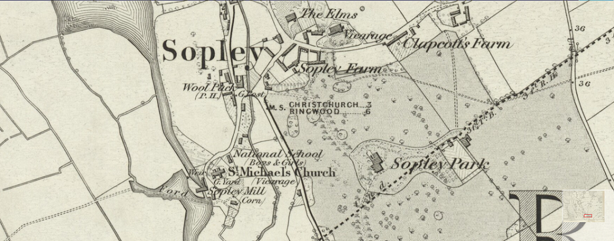
From military beginnings in 1745 the Ordnance Survey had progressed and created this Six-Inch Map; Hampshire & Isle of Wight LXXVIII (includes: Hurn; Ringwood; Sopley; St Leonards and St Ives.), Surveyed: 1870, and Published: 1872
The adjacent map of Sopley is an extract, as is the Ripley map, below
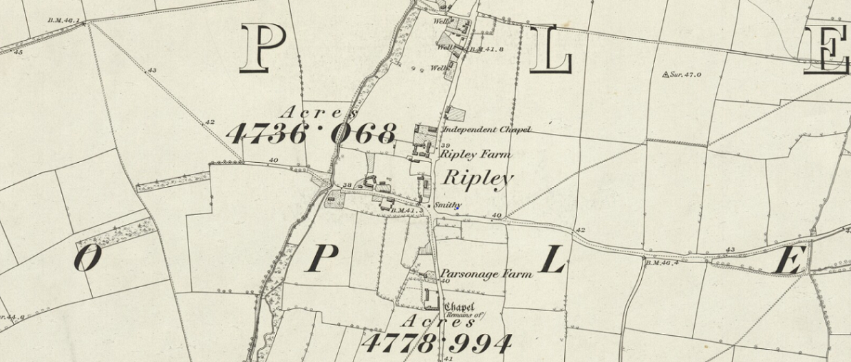
Ripley is a small village to the North of Sopley, so perhaps should have been above Sopley here, but that was not the narrative.
The Ripley map interestingly shows the remains of a chapel and an independent Chapel. This may become particularly relevant later when looking for non-conformist marriages.
At six inches to the mile there is so much information on these maps. The church, vicarage, the mill, and Sopley Park.
Mapping is fascinating and links well with family history. At this scale you can see individual building, which in turn give an idea of the size of the community. Although the parish of Sopley is bigger than just the village.
The changes with how maps are made and used are as profound as the change in Sopley itself, indeed more so. Below is a Google Map image of Sopley, zoomed out slightly to take in the whole of the village. An interesting comparison of both mapping and the village. The Church, the mill, the pub, 'The Woolpack', and Sopley Farm are all still on the map, as are a number of other recognisable shapes. Apparently the house at Sopley Park was demolished in 1988 and the park now houses Morelands Bible college. Another source of a map of the Sopley village and surrounding area can be found here and at a later date.
I found a photo of the old Sopley Park house together with an album of Sopley village. The Woolpack is thatched and is Strong's of Romsey. That brings back memories. Strong's brewery used to be in the centre of Romsey and was on the site which is now derelict.
Follow link for attribution and to go to the Sopley Album by Alwyn Ladell.


The tithe map for the area should provide some additional information and possibly link buildings and people.
Hundreds, Parishes and the Domesday Book
Before we go there, we need to go back to Hundreds and Parishes. The Christchurch Hundred is nicely shown of this 1832 Boundary Map from Vision of Britain Through Time.The map is part of the H.M.S.O. Boundary Commission Report 1832. Again, run the mouse over the map of Southern Hampshire and New Forest, into Christchuch Hundred.
Most of the counties of England were divided into hundreds from the late Saxon period and these were, with a few exceptions, effectively abandoned as administrative divisions in the 19th century. With such longevity comes a suggestion of name and location stability. Sometimes counties are subject to the machinations of political will, with changes of names and size. The fact that Christchurch (Town) is now in Dorset instead of Hampshire is a case in point.
Above the hundred was the shire, under the control of a sheriff. Hundred boundaries were independent of both parish and county boundaries, although often aligned, meaning that a hundred could be split between counties, or a parish could be split between hundreds.
The use of "hundred" for a division of a county has what the OED describes as an "exceedingly obscure" etymology. It may once have referred to an area of 100 (or possibly 120) hides, though a "hide" is not a specific area: instead it was conceptually the amount of land required to support a family. Alternatively it may have been based on the area liable to provide 100 men under arms, or because it was an area originally settled by 100 men at arms. There was an equivalent traditional Germanic system, in Old High German a huntari, a division of a gau (and described as early as AD 98 by Tacitus – the centeni), but the OED believes that the link between the two is not established.
The term "hundred" is first recorded in the laws of Edmund I (939–46) as a measure of land and the area served by a hundred court. In the Midlands, they often covered an area of about 100 hides, but this did not apply in the south; this may suggest that it was an ancient West Saxon measure that was applied rigidly when Mercia became part of the newly established English kingdom in the 10th century. The Hundred Ordinance, which dates to the middle of the century, provided that the court was to meet monthly, and thieves were to be pursued by all the leading men of the district. The name of the hundred (called "wapentake" in the Danelaw) was normally that of its meeting-place. Suggesting that Christchurch was the ancient meeting place of the Christchurch Hundred.
During Norman times, the hundred would pay geld based on the number of hides. To assess how much everyone had to pay, a clerk and a knight were sent by the king to each county; they sat with the shire-reeve (or sheriff), of the county and a select group of local knights. There would be two knights from each hundred. After it was determined what geld had to be paid, the bailiff and knights of the hundred were responsible for getting the money to the sheriff, and the sheriff for getting it to the Exchequer. Note the similarity to the election of two knights of the shire in A Poll Book And Electoral Registers 1734 mentioned in The Tilley Family Migration on this site.
In England a hundred was the division of a shire for military and judicial purposes under the common law, which could have varying extent of common feudal ownership, from complete suzerainty to minor royal or ecclesiastical prerogatives and rights of ownership. Until the introduction of districts by the Local Government Act 1894, hundreds were the only widely used assessment unit intermediate in size between the parish, with its various administrative functions, and the county, with its formal, ceremonial functions.
The Christchurch Hundred was gifted to Richard De Redvers, The 1st Feudal Baron of Plympton In Devon as part of the 'The Honour of Christchurch', as stated at the top of the page. He became a huge landowner, with vast swaths of land and properties in many counties, and a very very wealthy man. Sopley was part of that.
Domesday Book, (Latin: Liber de Wintonia "Book of Winchester") is a manuscript record of the "Great Survey" of much of England and parts of Wales completed in 1086 by order of King William the Conqueror. The Anglo-Saxon Chronicle states:
Then, at the midwinter [1085], was the king in Gloucester with his council ... . After this had the king a large meeting, and very deep consultation with his council, about this land; how it was occupied, and by what sort of men. Then sent he his men over all England into each shire; commissioning them to find out "How many hundreds of hides were in the shire, what land the king himself had, and what stock upon the land; or, what dues he ought to have by the year from the shire."
It was written in Medieval Latin, was highly abbreviated, and included some vernacular native terms without Latin equivalents.[4] The survey's main purpose was to determine what taxes had been owed during the reign of King Edward the Confessor, which allowed William to reassert the rights of the Crown and assess where power lay after a wholesale redistribution of land following the Norman conquest.
The assessors' reckoning of a man's holdings and their values, as recorded in Domesday Book, was dispositive and without appeal. The name "Domesday Book" (Middle English for "Doomsday Book") came into use in the 12th century.
Sopley is recorded in the Domesday Book and the entry can both be seen and the transcription read hear, at the first free online copy of the Domesday Book. The page on which Sopley was recorded was Hampshire XXIII, shown to the right. Interestingly the Sopley entry states that the Hundred is Shirley and the population is just 10 homes. The 10 households consist of 3 villagers, 6 smallholders, 0 cottagers,and 1 slave. The mill is also mentioned. The Lord in 1066 is stated as being Edric, The name Edric is associated with 161 places across 25 counties, including 35 in Devon. He was also recorded as being Overlord to 4 places in 1066. Edric's influence was much reduced my 1086 with only 8 Manors across 7 Counties. Three manors held from 1066 to 1086 and five new replacing the 158 lost. Now of course there could be several people called Edric making up the above numbers. It could be just one each, or any combination between. Either way it is still a fundamental upheaval and change. Change of ownership, laws, and probably language to an extent.
The lord of Sopley in 1086 and the Tenant in Chief are stated as being William son of Stur. William had 16 places listed in 1086, all in Hampshire, whereas Richard de Redvers, aka Richard of Reviers, only has one. Lord and Tenant in Chief in 1086 of Mosterton, Beaminster, Dorset. A place with a population of 18 households. The Lord in 1066 is listed as Almer. This name Almer is associated with 179 places before the Conquest, in 26 counties far and wide across the country; From Ecclesford in Yorkshire, to Ufford in Suffolk, to Domellick in Cornwall. Only 17 Lords entries after the Conquest, in 12 counties, with just three as Tenant in Chief.
The hundred of Shirley is described as including, Winkton, Avon, Ripley, and Sopley, and has a population of 68 households.
Christchurch is also listed in the Domesday Book, twice. Total population of 47 households (very large). There were 8 places in the hundred of Edgegate in the Domesday Book, including Christchurch, with the largest being Holdenhurst.
Plympton is stated as being the Kings land in 1066.
Here I go on another tangent, well, two actually. The first is the Domesday Book, and the second is the data that can be extracted and visualized from the transcription of the Domesday Book, pertaining to the county of Hampshire and the village of Sopley. I found this article on the Doomsday Book, (note alternative spelling) 'THE DOMESDAY BOOK : VISUALIZATION TOOLS TO EXPLORE IDENTITY AT THE START OF THE SECOND MILLENNIUM' which in turn led me to Hull Domesday Project.
An extract from the article reproduced here for ease of reference gives an interesting insight into the time.
The Norman invasion of 1066 plunged England into a period of intense social upheaval. During his later years King William came under threat from a number of sources. Chief among these were King Canute IV of Denmark and King Olaf III of Norway. The policy of the time was to buy off these two aggressors with a fund called the Danegeld. The most probable reason for the compilation of the Domesday Book was to determine how much tax William was receiving and therefore the level of Danegeld that could be paid. The book records, for each settlement in England, its monetary value and any dues owed to the King. The fiscal information is shown at the time of the survey, before Domesday, and from before 1066. It is a complete record of lands held by the king and by his tenants and of the resources that went with those lands. Its compilation formalised a process of transition by recording which manors rightfully belonged to which estates. It ended years of confusion resulting from the gradual dispossession of the Anglo-Saxons by the Normans. It is also a snapshot of the feudal hierarchy showing the identities of the tenants-in-chief who held their lands directly from the King, and of their tenants and under tenants. Many of the details of the changes that occurred are recorded in the Domesday Book but in a way that would be quite alien to a modern social scientist or geographer. The information recorded within it is resistant to the techniques that would be applied to modern social surveys and census data. The inconsistencies and ambiguity present defy modern quantitative methods and standard digital tools. However, the data is typical of that used by historians and other researchers within the humanities and so form an important case study. What is required is a more fluid qualitative method that is closer to arts and humanities methodology than that of the social scientist.
Domesday records the nature and structure of society in 1086 but also tells us of the sweeping changes that had occurred in the intervening twenty years since the conquest. The fundamental problem is one of establishing the identity of individuals across the whole country. A single person frequently held land in more than one county but might be referred to in each case by different identities. These are not just variations in spelling but also in title and the way an individual is known, by a byname such as ‘the Wolf’, or a number of other names and titles of differing purposes. What one is faced with is a very detailed, colossal puzzle which requires ingenuity and creative thought to unravel. Textual methods are of only limited value but spatial analysis and visualization offer significant advantages. Existing Geographical Information System (GIS) tools might be applied but the purpose of this project is to develop digital visualization tools that will allow anyone, whether professional historian or interested amateur, to explore the content of the Domesday Book via a visualization tool that is sufficiently versatile (and free!) but easy to use to tackle information that resists the ‘traditional’ scientific methods of GIS. The project has scope for fresh thinking about visualization tools that cross disciplinary boundaries and open access to digital resources for analysis and study by new audiences. The experiences have value that extends far beyond the current application and have informed our general views on a more fluid, versatile approach to the visualization of qualitative and quantitative data in the arts and humanities.
Another insight in the form of a Hull Project presentation, about Domesday England.
The other part of the tangent is to collate data from the Open Domesday database into Excel, cross reference Hundreds and Places, and then map it into ESRI. If that is successful, then add more data about hundreds in the 1800s, to compare implied areas. The next stage would be to add the population information attached to the Manor information. More cross referencing. Then visualizations on Esri mapping. The one below is an early example. Much more to come.
Well, part way through the much more. Hundreds in Hampshire downloaded and imported into excel. Places correlated and Manors cross references to places making use of the APIs Open Domesday website and linked in Excel. Raw data extracted at one record level and converted into usable form. Now the even slower part of the process. Pulling up the website place record to validate the data extraction and matching, and at the same time creating a people dataset as there in not currently a people API. The process of data validation. Select the Places page of the Open Domesday website. Select an initial, say A. Work down the list looking for Hampshire. At each instance, open the page. Find the relevant records in the excel combined flat file. Are there more than one entry of the Place in the Domesday book, if so are there a corresponding number of entries in the flat file? Add the website Entry number to the flat file. Add some of the text based information from the website to the flat file including a hyperlink back to the website page. Check all to the data to ensure correlation. In some instances there will be #Values in the flat files. These are normally caused by the notes using fieldnames. As the data extraction uses the fieldname to determine the location of the data in the long string, inadvertently using for instance the word "Woodland" in the notes causes the wrong data extraction as "Woodland" is also a field name. A slight change of text in the notes normally sorts the problem. Woodland to Woods for instance. Once all of the extracted data is confirmed as correct, the people remain to be resolved, thereby progressively building the people dataset. Once all the data has been checked and added, the record status is noted as Confirmed. Back to the beginning, find the next Hampshire in the list and repeat.
Work progresses. Thats the 'A's validated. 7.14%
ESRI Migration Map
Under development Migration map
This map will change
According to another source, including a map at, Britian Express;-
There were only 18 towns of over 2000 inhabitants in the Domesday England of 1086. Of these towns, the two largest, London and Winchester, were left out of the Domesday Book entirely. The population of the entire country was probably between 1.2 and 1.5 million, most of them in the south and east, as you can plainly see by the distribution of major towns.
Searching for existing Domesday Maps I found this one displaying the Hundreds and Wapentakes. It is an extract of 'The Origins of Political Order and the Anglo-Saxon State'. I find it interesting how much information can be found on the internet to entice you away form the core subject, but is in itself a good read.
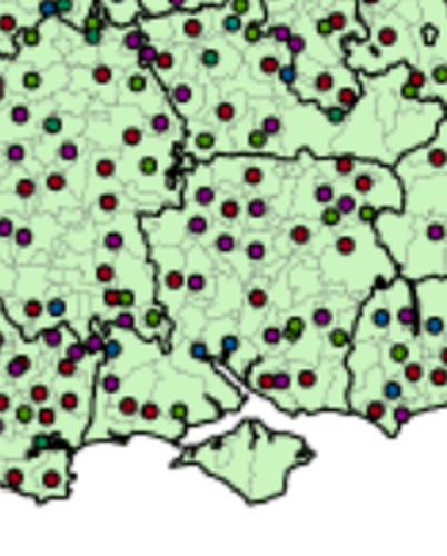
The adjacent map zoomed in several times to produce a fuzzy Hampshire extract.
If the spots on the map are meeting places, not each hundred has a mapped meeting place. There appears to be three red dots and one green in and around the New Forest.
I understand from the article that the red dots are open air meeting places, perhaps at the top of a mound or hill. Similarly green dots represent assemblies in burhs.
Burhs were set up in the reign of Alfred the Great as part of the defence of Wessex against the encroaching Danes who had taken over much of the rest of the Kingdoms. Southampton for instance is a know burh, which has since grown into a town, and now a city.
A tenth-century document, now known as the Burghal Hidage and so named by Frederic William Maitland in 1897, cites thirty burhs in Wessex and three in Mercia.
Southampton is shown on both the Burghal Hidage map below and as the green dot of a meeting place Burh at the head of Southampton Water.

Lymington appears to be on the Domesday Hundreds map as a green dot, as a Burh, but is not shown on the earlier 10th Century map.
Twynam, which was founded in the seventh century at the confluence of the rivers Avon and Stour which flow into Christchurch Harbour, the town was originally named Twynham but became known as Christchurch following the construction of the priory in 1094. Christchurch was thought to me the meeting place of the Christchurch Hundred in later centuries but is not shown as a dot of either colour on the Domesday Hundred Map. In the Domesday Book Christchurch is recorded as being in the Hundred of Edgegate and that Sopley, part of the Christchurch Hundred, was then part of Shirley Hundred. Shirley Hundred only had four places recorded in the Domesday Book. None of the four stand out as being or having a meeting place. Edgegate does not appear to have a dot either,
As yet a further aside, I like reading Historical Fiction, and the Bernard Cornwell books in the series 'The Last Kingdom' brings the period of Alfred the Great ((born between 847 and 849 – died 26 October 899) was King of Wessex from 871 to c. 886 and King of the Anglo-Saxons from c. 886 to 899) to life. These Saxon stories are also the basis of the TV series The Last Kingdom. Note from the author, "The Warrior Chronicles/Saxon Stories have been renamed The Last Kingdom series".
Tithe Apportionment
Time for a bit of time travel. Away from the Vikings, William the Conqueror, and the Domesday Book. Not all the way to the current day but to another significant change in the rural community.
Whereas an Agreement for the COMPUTATION of TITHES in the Parish of Sopley in the County of Southampton was, on the Eighteenth day of June in the Year One Thousand Eight Hundred and Thirty Nine confirmed by the Tithe Commissioners for England and Wales, of which Agreement, with the schedule thereunto annexed, ...

A jump to 18/06/1839 form 1086 in a single leap, missing out the Inclosure Acts of 1773 et al. Sometimes known as the Enclosure Acts.
I have recently purchased a copy of the Sopley Tithe Map and Award from the Hampshire Record Office. This is the record of the Tithe Survey for the Sopley area.
Tithes were originally a tax which required one tenth of all agricultural produce to be paid annually to support the local church and clergy. After the Reformation much land passed from the Church to lay owners who inherited entitlement to receive tithes, along with the land.
By the early 19th century tithe payment in kind seemed a very out-of-date practice, while payment of tithes per se became unpopular, against a background of industrialisation, religious dissent and agricultural depression. The 1836 Tithe Commutation Act required tithes in kind to be converted to more convenient monetary payments called tithe rentcharge. The Tithe Survey was established to find out which areas were subject to tithes, who owned them, how much was payable and to whom.
From the map and award I hope to be able to locate the place of residence of some of my ancestors.
The award, which may have also been known as a living, was granted to Reverend John Parish Hammond, Clerk Vicar of the Parish, and his successors, in the sum of £330 and 10 shillings per annum in respect of the vicaraul and small tithes. The Rector, William Wyndham, of Denton, Wiltshire, and his heirs and assigns, is granted £552, in respect of the Rectoral or Great Tithes of Corn and Grain. What sort of living would that provide? Depending on how it was calculated the vicar would be on, somewhere in the range between £28,360 and £380,000. Not too shabby. The rector would fair somewhat better, not surprisingly. His income range was £47,370 to £634,700, each year. Time to read some Jane Austen again? Quite a comfortable living.
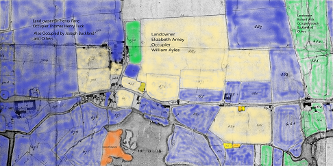
The very first entry in the schedule prompted another diversion including some therapeutic colouring in, albeit digital. The Tithe Map on the CD from Hampshire Record Office is not for reproduction. However, I have a subscription to The Genealogist and they have recently published the Tithe Survey data from the National Archives. It has predominantly the same information as the CD. However, it does provide a download button. The first entry of the Sopley schedule is a Landowner called Elizabeth Arney. She has one primary tenant and several lesser tenants. Using the tithe maps, the historic maps and internet maps, the majority of her holdings were found to be in and around Avon, in Hampshire. I downloaded the Tithe Map of Avon, part of the Parish of Sopley, and then colour washed the plots for the three major landowners in the area. There are a few plots not coloured in, generally in individual ownership.
Not quite the current fad of adult colouring in books, but similar.
I find it interesting that the large majority of the land is owned by just three people. I suspect that this is not that unusual for the period. In the Domesday Book period the Landowners would have predominantly have been the aristocracy. The blue is however a Sir, not quite blue blood, or perhaps he is. The orange represents the small amount of Common Land left after all the changes to rural life.
Elisabeth Arney owned 39 acre 1 rood 16 perch, or 39.35 acres, or 15.92 Hectares, and had to pay the vicar £4 14s 10d in Rent-Charge, each year. Together with a further £9 19s 7d to the impropriator (a person to whom a benefice is granted as their property). Is this the Rectors Share, in which case it was paid to William Wyndham.
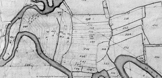
The next landowner on the schedule is George Aldridge. His middle name is either Clive or Olive. The Genealogist transcription opted for Olive. I'm more inclined towards the more conventional Clive. The easy bit is that he owns and lives at Sopley Mill. Easy to find on both old and current maps as the building is still there. The interesting thing for me is the another of his plots. Plot 497D, which is annotated as Sopley Sharphams, or something similar.
Looking at the plot on the tithe map it seems to be an area of strip farming south of his mill, on the other side of the river, not far from Sopley Common. This led me to looking for different names for strip farming and consequently a site on field systems. Open fields is one name, but that does not fit with Sharphams.
An extract of the article;-
The move towards enclosure gathered pace during the late 18th and early 19th centuries. At this time Parliamentary enclosure field systems were laid out through a series of Parliamentary Acts resulting in wholesale enclosure of land previously held within the open-field system. In total, 21% of England was enclosed by the Acts; 7 million acres of land was affected, two-thirds of which had been arable, the remainder waste. The Parliamentary fields in many ways resembled earlier regular enclosed field systems in that they were typically rectilinear/square in outline and set together, where topography allowed, with mathematical regularity.
Commons and open-field or strips were lost in this process. The strips have been replaced with fields, albeit still relatively small.
Parish of Sopley Tithe Apportionment Data Set
Although the paragraphs of this article are not dated it has been a few weeks since the last entry. I have been very busy extracting the data from the Tithe Apportionment and transcribing it into a spreadsheet. The images have detail pages and summary pages. Using both to create a form of double entry enabled me to validate my own input, and incidentally, that of the original scribes. The numbers for acres and the two rents were correct on the original and the double entry spreadsheet. There were a very few anomalies in spelling of names between detail and summary, and I opted for the detail version. One error was a tenant of Elizabeth Arney who was described as Henry Corbin in the Summary but George Corbin in the Detail. I have opted for George Corbin. I hope this will be confirmed by the 1841 Census.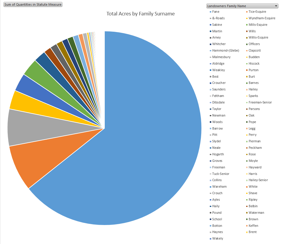
Using the spreadsheet I can now analysis land usage and ownership. See potential family ties. The total number of shops for the whole parish is amazingly low. The only industrial premises in the parish appears to be the Sopley Mill, whereas Farms abound. There are 46 plots which appear to be residences, the majority described as cottage, with some houses, farm houses, and one mansion house.
The latter being Sopley Park, which at the time was owned and occupied by George Brander Willis Esquire. George was a 1st Lieutenant in the Royal Artillery, from 17 November 1809 an fought in the Peninsular War. He was also a painter with his View of Bayonne (1814) being held in the Royal Collection Trust. Click here to see the image held at the Royal Museums Greenwich. George was the son of Revd James Willis, fought with Wellington and died on 29th August 1868, at the age of 79. He was about 20 when he became a 1st Lieutenant, and served his country in Holland, Spain and America.
However, the biggest landowner was Sir Henry Fane. He lived at plot 892, Avon Hills Cottage. the link to plot 892 is to The Genealogist website, which also holds images and index transcriptions of the Title Maps. I am a subscriber, so the link works for me, apologies if it does not work for you. I also used The Genealogist data to cross check mine if I was having trouble reading the script, or finding plots. Back to Avon Hills Cottage. I think cottage gives the wrong impression. Firstly the plot is 7 Acres 3 roods 30 perch, or 7.9375 Acres or 3.212 Hectares. That is very large for a cottage. Looking at other old maps and current Google Maps, plot 892 has Avon Tyrrel and Tyrrells Ford Country Inn & Hotel respectively. An extract from the hotel's website, 18th century Manor House hotel set in 8 acres of beautifully peaceful grounds on the edge of the New Forest. Tyrrells Ford Country Inn & hotel is situated in the Avon valley in Hampshire. Avon Tyrrel is has a rich history according to Wikipedia. Sir Henry Fane 26 November 1778 – 24 March 1840, also fought with Wellington, and had a distinguished army career, and served both as a member of Parliament and Commander-in-Chief of India. Sir Henry had holdings of about 2200 Acres across the Parish of Sopley, amounting to 64% of the Tithe area. Made up of Arable 1383.625, Meadow 302.5, Pasture 212.31, Wood 176.85, and others, across 80 tenants. The graph of Total Acres by Family Surname for the Parish of Sopley clearly illustrates the dominance of Sir Harry Fane in the Parish, and reinforces the map above with plots coloured in by landowner.
The Tice surname is next on the list, with a mear 8%. Even the Willis Family with the mansion house is just 1%, which is still a big landowner and very wealthy, just in a different league to Fane. This is only 1839, less than 200 years ago.
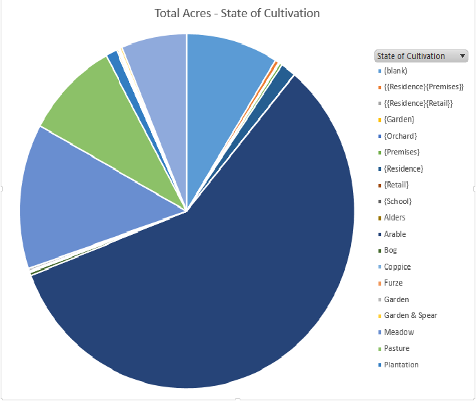
Again looking at the information extracted from the Tithe Apportionment using the spreadsheet. The graph represents the State of Cultivation recorded on the survey together with some reasonable assumptions based from the Lands and Premises data, shown in { }, with the largest being Arable 58%, followed by Meadow 13%, Pasture 9%, Wood 6%. Most definitely a farming community. The remaining significant slice of pie is (blank) at 9%, ie no recorded or implied use.
Church of England parish map
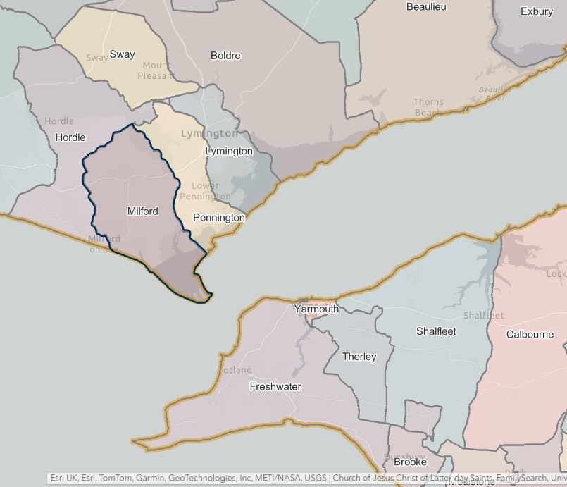
Below is a map centred on the parish of Sopley together with some statistics about the parish. Click on the parish to get the information.
Sopley village at the bottom left of the parish and Avon-Tyrell to the North and East corner. Click here to open map in browser.
Below in information found to date, in chronological order of the information.
Newspaper Article from the British Library
The article is OCR but needs lots of corrections, which I am working through.
Hampshire Chronicle - Monday 11 October 1790
Image © THE BRITISH LIBRARY BOARD. ALL RIGHTS RESERVED.
HAMPSHIRE GAME DUTY.
A LIST of the CERTIFICATES,issued in the County aforesaid, with respect to the said DUTY, between the 1st of July and the 1st of September, both Days inclusive, pursuant to Act of Parliament
DUTY at Ten Shillings and Sixpence each.
Gamekeepers. ¦ By whom deputed. ¦ Manors
FIFIELD, John, jun. ¦ John Fifield, Gent. ¦ ( Standbridge, a. Standbridge Erles, and two undivided third parts of the Manor of Roke )
The same [Guy, Thomas] ¦ E. B. Batson, Esq. ¦ Avon-Tyrell
Hall, Richard ¦ Sarah Cray, widow ¦ Overburgatt, [Over Burgate] a. Frlfen Court [Fryern Court?]
Extract of The Salisbury and Winchester Journal and General Advertiser of Wilts, Hants, Dorset, and Somerset dated 29 June 1829
MANORS of Overburgatt, Ibsley, Ellingham, and Movies Court, alias Rockford Movies, in the Parishes of Fordingbridge, Ibsley, and Ellingham, in the County of Southampton. NOT ICE is hereby given, That COURTS BARON and COURTS of SURVEY, will be holden for the above MANORS at the accus- ti mod Places within the said several Manors, 011 the Days and at the Hours undermentioned, and the several Persons Claiming to hold any Messuages, Tenements, Lands, or Hereditaments, under, or by virtue of any Copy of Court Roll, or Lease for Lives, or Years determinable on Lives, granted by the Lord of the said Manors or cither of them, for the time being, arc hereby required on the Days respectively undei mentioned to attend, and produce the Copies of Court Roll or Leases, under which they respec- tively claim to hold and to be prepared with proof of the the existence of the Lives named therein, also to pay their Quit Rents and do their Suit and Service. Overburgatt Court— Tuesday, the 7th of July, at 10 o'clock in tlte forenoon, at Mr. James Cheater's, Vinards Farm. Ellingham and Moyles Court— Wednesday, the 8th of July, at 11 o'clock, at Mr. Joseph Battens, at Rockford. Ibsley Court— Thursday the 9th of July, at Mr. Na- thaniel Philpotts, at Ibsley. Dated this 19th day of June, 1829.
Note Overburgatt could be Fryern Court, a listed building, in Over Burgate near Fordingbridge.
The Christchurch Registration District on UKBMD explained.
A Parish map of Hampshire held on Ancestry.
County map of Hampshire with Parish boundaries held on GENUKI
Go to a page about the Registration District Christchurch (1837-1925), Hampshire, England on my TNG database site.
Map and lists of English Jurisdictions 1851, including Hampshire
more later
Christchurch
Where is Christchurch in relation to Sopley?
Just 4.4 miles, or more importantly, about 11/2 walking time. Walking time is the most significant in this age as by and large, this was the normal form of transport.
The Market Hall was built in the Market Square in 1745 and was moved to its present site at Blanchard’s Yard in the High Street in 1859. This was largely because of the increase in traffic which resulted from the railway, that reached Christchurch Road Railway Station in 1847. This is now the Holmsley Tea Rooms some seven miles from the town. The Market Hall at the Square only gave eleven feet clearance which was the cause of traffic jams for horse drawn coaches and wagons. Particularly after the arrival of the railway at Holmsley.
So if Christchurch market dates from Saxon times, and it is very unlikely that Sopley had a comparable market, if one at all, it would seem quite probable that some of the people of Sopley would travel to market from time to time.
I used to know somebody who was quite old at the time, who lived his whole live in East Dereham, Norfolk. When I asked him one time if he had ever visited London. "Oh no! Why would I want to do that. I have been to Norwich three times in my live. that is enough for me." All in a heavy Norfolk accent which I will not try to portray here. Norwich is only about 15 miles from East Dereham.
While we are at the Christchurch History Society site, they have created a list of surnames mentioned it the Christchurch times. Extract below .
The Christchurch History Society has microfilm copies of The Christchurch Times from 1861 to 1918 and from 1925 to 1983 which is the majority of the duration of its publication. The paper was not published from 1918 to 1925. Limited microfilm copies of The Christchurch Times from 2nd January 1858 to 29th December 1860 are also available.
A full list of surnames has been transcribed to create a list the surnames of people in Christchurch and the surrounding villages that have been mentioned in the The Christchurch Times. The list is held as a database of over 153,200 names for the years 1855 to 1938.
| Name | 1850's | 1860's | 1870's | 1880's | 1890's | 1900's | 1910's | 1920's | 1930's | My note |
|---|---|---|---|---|---|---|---|---|---|---|
| Telley | This variation of name not found on list | |||||||||
| Telly | This variation of name not found on list | |||||||||
| Tilley | 11 | 15 | 25 | 34 | 43 | 53 | 27 | 40 | 20 | Predominant spelling of the name from this source during this period. |
| Tilliy | This variation of name not found on list | |||||||||
| Tilly | 1 | 2 |
This is however outside the period of the start of our story, but is probably indicative of the use of the various potential spellings.
As an aside, when did newspapers start?
William Caxton had introduced the first English printing press in 1476 and, by the early 16th century, the first 'news papers' were seen in Britain. They were, however, slow to evolve, with the largely illiterate population relying on town criers for news.
Between 1640 and the Restoration, around 30,000 'news letters' and 'news papers' were printed, many of which can be seen today in the British Museum.
The first regular English daily newspaper, the Daily Courant, was launched with the reign of Queen Anne in 1702.
1649 - Cromwell suppressed all newsbooks on the eve of Charles I's execution.
1772 - Hampshire Chronicle launched, Hampshire's oldest paper.

Photo from Dorset Attractions
Christchurch or Twyneham
Previously Hampshire but now Dorset
Lets start with a Historic Walk around the town courtesy of Christchurch History Society.
Then a visit to British History Online.
To its position between the rivers Avon and Stour the site of Christchurch owed its earlier name of Twinham, representing an old English betwux thæm eaum, 'between the waters.' The Hampshire Twinham first appears in the chronicle in the annal for 901, which relates the events of 899, the year of King Alfred's death. Upon that event Ethelwold, a younger son of King Ethelred I, seized the estates of Wimborne of Twinham 'without the leave of the king or the Witan.' The suppression of his revolt was soon accomplished; its details are not relevant here. But it is important to note that in the annal of 901 Wimborne and Twinham are described, not as burhs, or strong places, but as hams, the word most nearly approaching to the Norman manoir. It is evident that in 899 Twinham possessed no fortifications other than belonged to the normal estate of the time. On the other hand, it is included in the burghal hidage, which dates from approximately 920, and was therefore fortified and made a borough at some time in the first quarter of the 10th century.
In 1086 the 'borough of Twinham' belonged to the king, who owned thirty-one messuages there, each of which paid 16d. land gavel. Six others, worth 13s. 4d., belonged to the priory. In the early 12th century the borough proper became a mesne borough, being granted about 1100 to Richard de Redvers as part of the honour of Christchurch (q.v.). From that date the manor of the borough followed the same descent as the rest of the honour till 1791, when Sir George Ivison Tapps sold it in September 1791 to the Rt. Hon. George Rose, who held various official appointments during Pitt's administrations. In 1796 George Rose settled it upon his son Sir George Henry Rose on his marriage, who again in 1820 brought it into a settlement upon the coming of age of his son George Pitt Rose. Sir George Henry Rose was still holding in 1834, but in 1863 he sold it to the trustees of the Earl of Malmesbury, and the present earl is now lord of the manor.
The earliest grantor of municipal privileges was probably Richard de Redvers. His son Baldwin first Earl of Devon in a charter, known through a later confirmation, in about 1150 granted the burgesses exemption throughout all his land from gable of standing in the market, from custody of thieves and prisoners, from the Whitsuntide penny for ale, from the reaping of half an acre and the carrying of writs, from toll of salt and from every custom of trade; he also remitted to them 10s. out of the 70s. (formerly £4) which they were wont to render for the toll of the town. There is apparently no evidence of another charter until that of Baldwin the seventh earl, quoted in the same confirmation. In this the earl not only granted the burgesses market rights (vide infra) but confirmed to them common of pasture in the meadows of Stockmead, Beremead and Bernardsmead after his hay had been carried, on payment of 30s. yearly, and freedom from the obligation of ransoming their sons and daughters, both of which privileges they had enjoyed in the time of his father, in which matter the Lady Amice, his mother, gave testimony in their favour.
Parishes of Hampshire
Great Britain, Atlas and Index of Parish Registers from Ancestry. It takes me a while to find this map on Ancestry every time I want to look at it, hence the link directly to it. I don't know if it will work without a subscription.
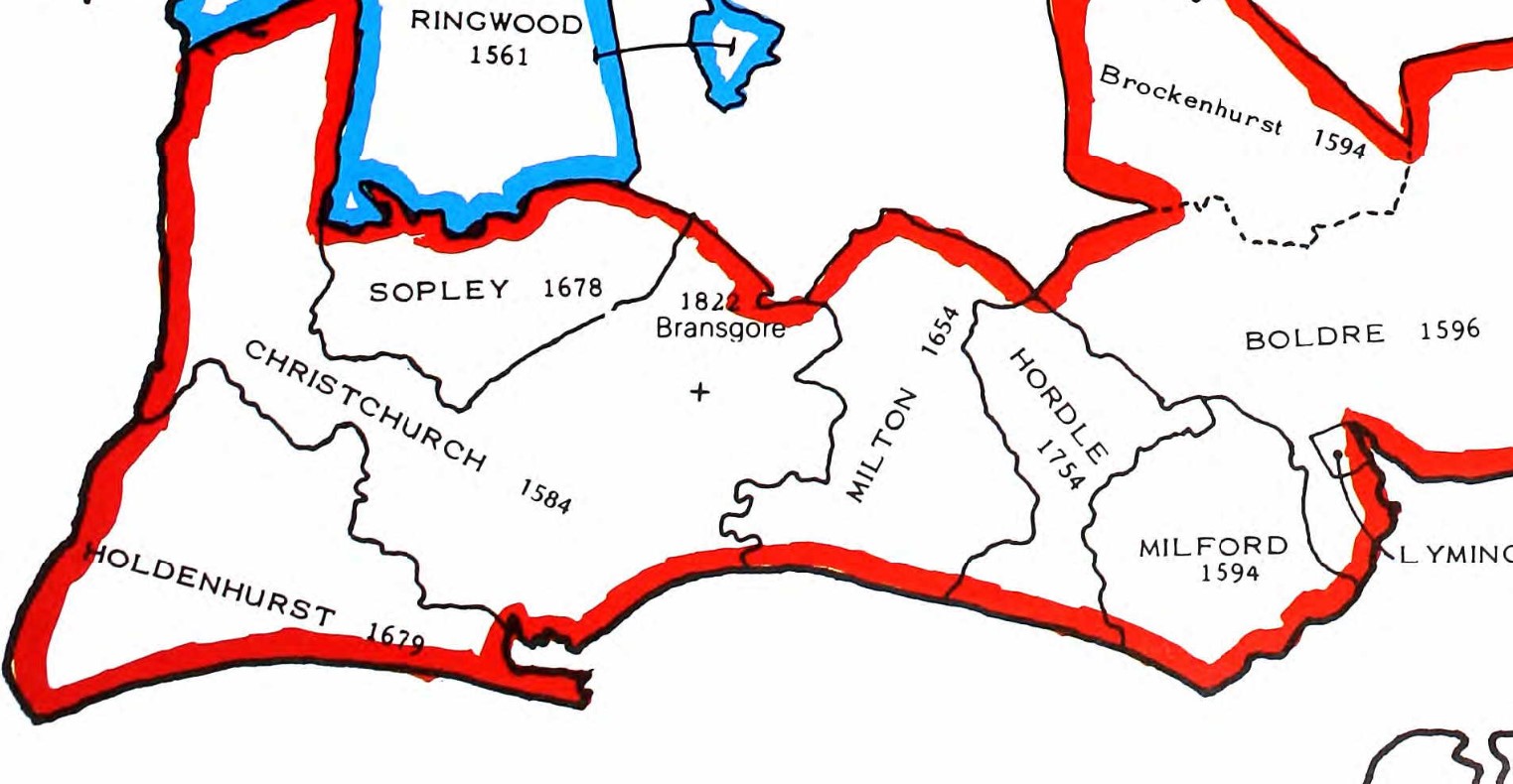
Parish Registers for Christchurch started in 1584 and for Sopley in 1678.
1600s
The 17th Century
John Tilley
John Tilley, born 1665 died 1727, of the New Forest
Ten generations ago, John Tilley was born in or nearby the small hamlet of Sopley, Hampshire, England, and the year was 1665.
He was my 8th Great-Grandfather.
He may be the start of the story, but not of the migration as he was born and died in the same small hamlet of Sopley.
Ancestry Synopsis
When John Tilley was born in 1665 in Sopley, Hampshire, his father, Mr. Tilley, was 30. He married Martha Spearen on 9 October 1683 in his hometown. They had three children during their marriage. He died in 1727 in Sopley, Hampshire, at the age of 62, and was buried there.
Mr Tilley referred to is just a placeholder father at the moment with just a guess at his age
John Tilley who sailed on the Mayflower
For the avoidance of doubt, his was not the John Tilley who was baptised on 19 December 1571 at Henlow, Bedfordshire, England, the son of Robert and Elizabeth Tilley. Who latter married Joan Rogers nee Hurst, on 20 September 1596 at Henlow, Bedfordshire, England, the Daughter of William and Rose Hurst and Widow of Thomas Rogers. This John Tilley sailed on the Mayflower and died sometime during the first winter at Plymouth, likely between January and March 1621. Nor was it any of his offspring.
Tilley was a relatively common name with a wide dispersion across England as shown on this Ancestry page.
Timeline Context
Timeline Context
1620s
The Mayflower was an English ship that transported the first English Puritans, known today as the Pilgrims, from Southampton and Plymouth, England, to the New World in 1620. There were 102 passengers.
1640s
The English Civil War (1642–1651) was a series of armed conflicts and political machinations between Parliamentarians ("Roundheads") and Royalists ("Cavaliers") over, principally, the manner of England's governance.
1660s
Charles II (29 May 1630 – 6 February 1685) was king of England, Scotland and Ireland. He was king of Scotland from 1649 until his deposition in 1651, and king of England, Scotland and Ireland from the restoration of the monarchy in 1660 until his death in 1685.
The Great Plague, lasting from 1665 to 1666, was the last major epidemic of the bubonic plague to occur in England. ... The Great Plague killed an estimated 100,000 people—almost a quarter of London's population—in 18 months.
John Tilley was born 1665
The Second Anglo-Dutch War (4 March 1665 – 31 July 1667), was a conflict fought between England and the Dutch Republic for control over the seas and trade routes, where England tried to end the Dutch domination of world trade during a period of intense European commercial rivalry.
1665 The city of New Amsterdam in the Province of New York is reincorporated as New York, named after James, Duke of York, and the first Mayor appointed.
31 October 1665 – Parliament passes the Five Mile Act preventing non-conformist ministers from coming within five miles of incorporated towns or the place of their former livings.
1665 - 1667 The Great Plague forces the closure of the University of Cambridge, where Isaac Newton is a student. Newton retires to his home in Lincolnshire for safety, and stays there for two years. During that time alone, Newton will make ground breaking discoveries in mathematics, calculus, mechanics, and optics, and lay the foundations for his books Philosophiæ Naturalis Principia Mathematica and Optiks.
1666 September 2–5 – Great Fire of London: A large fire breaks out in the City of London, in the house of a baker on Pudding Lane, near London Bridge. The fire destroys more than 13,000 buildings (including Old St Paul's Cathedral), but only six people are known to have died, whilst at least 80,000 were left destitute and homeless. The re-surveying of property is credited with giving both cartography and the practices of surveying a leg up, as well as resulting in the modern definition by John Ogilby of the statute mile, as 1760 yards.
...
A time of great change but perhaps not all impacting on the rural community in and around the New Forest.
Tilley families in the area
Tilley families in the area
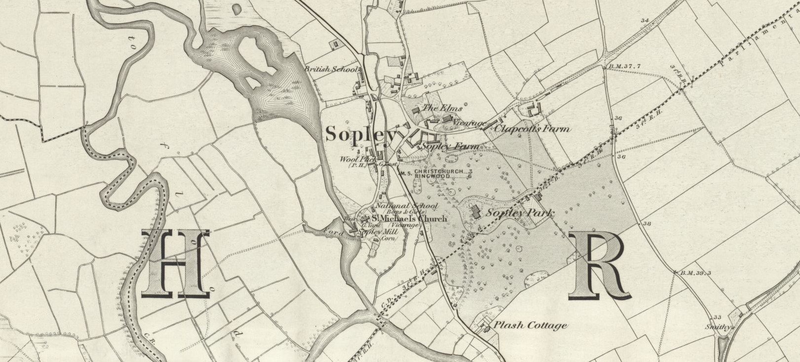 OS 6 Map Sopley - OS Six-inch England and Wales, 1842-1952 - Hampshire & Isle of Wight Sheet LXXVIII Surveyed: 1870, Published: 1872 {Click on the map to open in a new window}
Sopley is an ancient settlement going back to before the Doomsday book and is described in this article. It is on the edge of the New Forest. The nearby area is sometimes in Hampshire and sometimes in Dorset depending on various boundary changes. Most of the employment in the area would have been engaged in either rural activities or supporting the large number of family estates in the area. Sopley Park and Winkton House being a couple of the closest.
A couple of centuries later and Sopley is still a rural community as seen on this 1872 Ordnance Survey Map. More information on Sopley can be found on Vision of Britain and British History Online. Sopley was in the Christchurch Hundred from this 1832 Boundary Map. Another useful Boundary Map updated up to 11/12/1899 is found here, zoom in to find Christchurch, and then Sopley. From the Vision of Britain Through Time analysis 70% of Sopley families are engaged in Agriculture from the 1831 Census data.
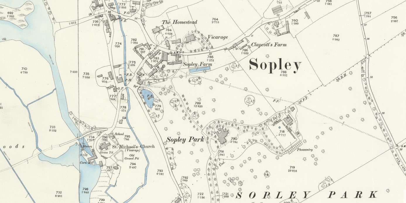 OS Map 25 Sopley - Hampshire and Isle of Wight LXXVIII.16, Revised: 1896, Published: 1898 {Click on the map to open in a new window}
A similar map to the Six inch map above, but this one is 25 inches to the Mile, with more detail. However, we don't have a specific location of John Tilley other than Sopley.
There appear to a number of families with surnames of Tilley, Tilly, Telley, and other derivatives of the name. At the time most people could not spell, read, or write so it was down to the person, generally writing in a register of births, marriages or deaths, to decide how a name was spelt based only on the pronunciation given. Derivations are therefore to be expected.
The names appear in both regular and non-conformist registers in Boldre, Ellingham, and Ringwood as well as Sopley. At this stage I don't know if any of these families link at sometime further into the past.

Some of the families are in non-conformist registers from the Ringwood Great Meeting House in 22 Meeting House Lane (Presbyterian). The building still exists. In 1672 licence was granted for a Presbyterian to preach at the house of Widow Saunders at Sopley. There is also a Congregational mission room in Sopley.
The Parish Church in Sopley is St Michael & All Angels. The church is Grade II* listed and is also detailed on Historic England. A photo of the church by Peter Facey can be found here. and adjacent.
The Parish of Sopley has an entry in British History Online.
The Sopley Church, of St. Michael and All Angels, has parish registers that are contained in four books, the first having all entries from 1682 (burials from 1678) to 1731; the second all from 1732 to 1786, the marriages till 1754 only; the third is the printed marriage book 1754 to 1812, and the fourth has baptisms and burials 1786 to 1812.
From this it is unlikely to find records of John Tilley's birth and baptism in 1665 or thereabouts, as that predates the parish registers, nor who his parents were.
Exploring John Tilley b 1665
Exploring John Tilley b 1665
At the time of writing the parents of John Tilley appear to be unknown. Sources used to date to attempt to find them include Ancestry, FindMyPast, FamilySearch, The Genealogist, The Hampshire Genealogical Society, and MyHeritage. So the story really starts with the marriage of John Telley and Martha Spearen on 9th October 1683, in the Parish of Sopley. This record was found on the CDs of The Hampshire Genealogical Society.
If my Family Tree is correct John Tilley is my 8th Great-Grandfather. A mere 10 generations back.
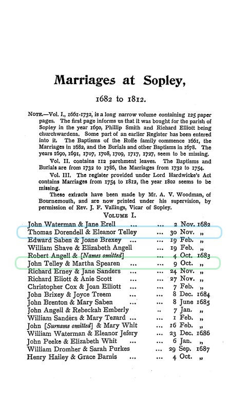 Phillimore Marriages at Sopley 1682 to 1812 P95
Details and the tree of this branch can be found at my Tilley Migration Family Tree constructed within the The Next Generation of Genealogy Sitebuilding "TNG".
However, before tracing the tree towards the current time, let us explore the inhabitants of the village of Sopley. The parish marriage records start in 1682. Phillimore Marriage Registers, 1531-1913, Hampshire Marriage Registers, Vol 7, contains Marriages at Sopley, 1682 to 1812 commencing at page 95. I started a One Place Study of Sopley based on this information. Analysis of the first 13 years indicates that of the 67 recorded marriages there are 55 unique surnames. Allowing for part of the population to be outside of marrying age it seems reasonable to assume that the population of Sopley at about 1690 consisted of about 100 families. Duplication of surnames would therefore suggest being of the same family, albeit not necessarily siblings. Tree statistics for OPS of Sopley can be found here.
During this exercise I found note of a marriage between Thomas Dorendell & Eleanor Telley on 30 Nov 1682. Four lines further on we find John Telley & Martha Spearen 9 Oct 1683. Could Eleanor be a sister of our John. It does seem quite probable. I not sure even DNA on both branches would provide definitive proof as this is ten generations back.
I would note at this point that dates are somewhat different during this part of history. This is the note I add to records of that age; 'The Calendar (New Style) Act 1750. The Act had two parts: first, it reformed the calendar of England and the British Dominions so that the new legal year began on 1 January rather than 25 March (Lady Day); and, second, Great Britain and its Dominions adopted the Gregorian calendar.' Yes, New Years Day, 25 March! Not changed until 1750.
Thomas Dorendell & Eleanor Telley m 30th November 1682
Back to the potential of John having a sister called Eleanor. I have been provided with some scans of records, which do not conclusively prove the relationship, but do make the same link and explore the Eleanor side of the tree. The records also demonstrate very clearly how variable the spelling of names can be so far back. One person has different spelling of his surname for his birth, marriage, and death, according to this information. Understandable considering the extent of illiteracy at the time. In 1660 upon the restoration, Latin, the language of the courts, which had been prohibited by Cromwell, made a comeback. Some parish records where in Latin. Further confusion.
I have added Eleanor to the Tilley Migration Family Tree, not knowing where it might take us. Statistics for that tree can be found here.
Continuing to explore Eleanor, or more precisely her husband Thomas Dorendell. Some of the information provided suggests that Thomas Dorendell was born in Ringwood and that his name was then recorded as Thomas Durndole. There is a Transcription of England Births & Baptisms 1538-1975 in FindMyPast that records a Thomas Durndole was baptised on 4 Sept 1659, in Ringwood, and that his father was Robert Durndole.
The county of Hampshire has in the past been called "Southamptonshire" and appears as such on some Victorian maps. The name of the administrative county was changed from 'County of Southampton' to 'County of Hampshire' on 1 April 1959. The short form of the name, often used in postal addresses, is Hants. Wikipedia. The old name appears as the place of embarkation of many of the immigrants into Ellis Island. It is recorded in the 'Commonwealth Instrument of Government, 1653, which was adopted by Oliver Cromwell when he assumed the office of 'Lord Protector' in 1654.
John Telley & Martha Spearen m 9th October 1683
This is the sixth record of the Phillimore Marriages at Sopley 1682 to 1812. Circled in green on the adjacent image.
John and Martha had three children, two sons and a daughter. Or at least that is the full extent of the records found so far. It seems strange that there were only three children at a time when a dozen was not unusual. The records suggest that Martha lived beyond the birth of the last known child.
The children were Edmund, John, and Martha, all born in Sopley, Hampshire.
Something about the children on the next Tab.
Children
Edmund
Edmund Tilley b 1684 Sopley
John
John Tilley b 1685 Sopley
Your text...
Martha
Martha Tilley b 1688 Sopley
Your text...
next 5
Your text...
ESRI Migration Map
Under development Migration map
This will change
more later
George Tilley
spare 3
Your text...
Your text...
1700s
The 18th Century
Poll book and Electoral Registers 1734
 In Ancestry there is a Poll book and Electoral Registers 1734. Possibly created for the 1734 British General Election. Note that it was the parliament of Great Britain. The union with Ireland in 1800 led to the creation of the United Kingdom. The is a considerable difference between who can vote now and who could vote then, and not just by gender. The National Archives has an interesting article. Until 1832, most voters were freeholders and others who could meet property requirements for the franchise, and poll books list only those who actually cast a vote.
An extract below as who could vote, and therefore be included on the Electoral Register.
Before 1832 the basic qualification for the vote in county elections was ownership of freehold land worth 40 shillings (£2) a year by men aged 21 and over. Until 1774 the man had to reside in the county in which he voted; no woman was eligible. Forty shillings had been fixed by an Act of 1429 to cut out "a great, outrageous, and excessive number of people, of which the most part was people of small substance and no value ... [who] pretended a voice equivalent to ... the most worthy knights and esquires ... whereby manslaughter, riots, batteries and divisions among the gentlemen and other people of the counties shall very likely rise and be". It was said that an income of. forty shillings a year made a man independent, being sufficient to furnish him with all the necessaries of life. By 1832 forty shillings would just about support a labouring man for a month, but the number of people who had such an estate in England and Wales was then only about 247,000. From 1763 the holders of annuities or rent charges on freehold land were also entitled to vote. In 1832 the right to vote in county elections was extended to include some 123,000 copyholders and leaseholders for periods of years on property worth £10 a year (reduced to £5 a year in 1867). The franchise was further extended in 1867 to tenants at will paying a rent of £50 a year.
The value in 2017 of £2 a year can be calculated in many different ways as shown here, with results ranging from £1,303 to £741,000.
It is the New Forest Division of the Poll Book that is of particular interest to us. The candidates are P C S L, Lord Harry Pawlett, Anthony Chute Esq. Sir Simeon Stewart, Edward Lisle Esq. The voters of Sopley can be seen on these two pages. Twenty eight people in total with six of that number being Elliot. By the 1790 General Election, the Poll Book only contained eight people with a freehold in Sopley, who voted. Is it a case of the population becoming less wealthy or less inclined to vote? I will check who lived in the big houses in the village, and how they voted.
As an aside, the total votes cast for the New Forest Division were, P. 309, C. 303, S. 404, L. 454, Total 1,470, with the winer for the Division taking 31% of the vote. The overall winners elected to parliament of Great Britain for the County of Southampton were:
- Harry Powlett, 4th Duke of Bolton PC (24 July 1691 – 9 October 1759), known until 1754 as Lord Harry Powlett, was a British nobleman and Whig politician. He sat in the House of Commons from 1715 to 1754, when he took his seat in the House of Lords.
- Edward Lisle Esq
In amongst all the names was a Thomas Durndell . on page 94, where he both had his freehold and lived in Christ-Church. He voted for S and L. However, just having a similar name in approximately the right part of the country does not confirm this person as a relative. It does however, make them a person of interest. Someone worth looking into further.
Frequently it is random wandering around a subject which leads to little gems. The investigation around the One Place Study of Sopley may provide both probable and improbable names. Both are as important. Sopley is an ancient settlement with associations to aristocracy and royalty. Sopley is part of the 'Hundred of Christchurch', which in turn is part of the 'The honour of Christchurch'. The 1st feudal baron of Plympton in Devon, Richard de Redvers, after acting as one of the principal supporters of Henry I in his struggle against his brother Robert Curthose for control of the English throne, was rewarded with estates that made him one of the richest magnates in the country. After the grants from the king, Richard's Devon estates probably consisted of around 180 Domesday manors, including Tiverton and Honiton, as well as the boroughs of Exeter and Plympton. He held the honour of Christchurch which consisted of many widely scattered manors in several counties. He held virtually all of the Isle of Wight (the exceptions being two manors held by the bishop of Winchester), and the island remained in his family until King Edward I bought it from a dying Isabella de Fortibus in 1293. His son became the 1st Earl of Devon. Just because the Earl of Devon held Sopley in his collection of lands does not mean that he ever livid there or even visited. It is though Plympton, Exeter, and Carisbrook Castle are more likely residences. It is fascinating to learn something of the lives of people in such a distant time.
Jump forward 5 or so generations, and a local of the area, Thomas Fripp meets Sarah Tilley, and they marry on 2 October 1834 when he was 23 years old. Within the 1851 Census, 17 years after their marriage, he is recorded working as a Bailiff - 100 acres employing 5 Labourers and 3 Boys. They had had 4 sons and one daughter together. They also had two servants.
Possibly working at Ossemsley Manor House. Ossemsley is near both Milton and Sopley. An Ordnance Survey map of the period shows the location of Ossemsley Manor House and the nearby Hinton Park, in Hinton Admiral.
Newspaper Article from the British Library
The article is OCR but needs lots of corrections, which I am working through.
Hampshire Chronicle - Monday 11 October 1790
Image © THE BRITISH LIBRARY BOARD. ALL RIGHTS RESERVED.
HAMPSHIRE GAME DUTY.
A LIST of the CERTIFICATES,issued in the County aforesaid, with respect to the said DUTY, between the 1st of July and the 1st of September, both Days inclusive, pursuant to Act of Parliament
DUTY at Ten Shillings and Sixpence each.
Gamekeepers. ¦ By whom deputed. ¦ Manors
FIFIELD, John, jun. ¦ John Fifield, Gent. ¦ ( Standbridge, a. Standbridge Erles, and two undivided third parts of the Manor of Roke )
The same [Guy, Thomas] ¦ E. B. Batson, Esq. ¦ Avon-Tyrell
Also,
Burton, W. Shepherd ¦ L. T. Holmes, Esq. ¦ Offumfley alias Ofmondfleafe (Ossumsley) {is this the same place as Ossemsley}
Goldwyer, George ¦ George Iveson Tapps, Esq. ¦ Hinton Admiral
Willis, James, Clark ¦ John Compton, Esq. ¦ Sopley
Quite inconclusive looking at the 1790 Game Duty Certificates.
1800s
The 19th Century
Tithe Maps of Hampshire
Tithe Maps of Hampshire
On to the Tithe Maps for Hampshire. Search for Fripp initially and we find a John Fripp as Landowner and Occupier {Link to TheGenealogist search result, then £} in the Parish of Old and New Milton, near Walkford Brook, including farm land in Walkford Common. The date of the record is 28th August 1841.
A possible match for the location of his farmhouse is shown in the Google Map below. It has not been geolocated using layering on to Google Earth as I have done elsewhere.
If this is the right place it is a mere eight fields or 1.3 miles, as the crow flies, away from Ossemsley Manor House
The search also pulled up a James Fripp {Link to The Genealogist search result, then £} who lived near Lea Green, between Downton and Everton, just off Christchurch Road, in the Parish of Hordle. The property was owned by Elizabeth Fluder according to the transcript. Again, and approximate location of his farm, below.
However, the most significant result of that search was finding Thomas Fripp {Link to TheGenealogist search result, then £} who occupied Tiled House, and some surrounding fields, all owned by Colonel Roberts, on the Ossemsley Manor House estate.
George Broomfield and Isaac Hurst {Link to The Genealogist search result, then £} were also occupiers of Colonel Roberts land. The latter at North Ossemsley Farm.
Back to the Family Tree
Back to the Family Tree
Sarah Tilley married Thomas Fripp on 2 October 1834 in Milton Hampshire. Milton could have been the place of registration rather than the actual place of the wedding.
Baptisms of some of Sarah's siblings are recorded as having taken place in Christchurch, as dissenters. The baptism was not performed in the Established Church.
According to the Registry, of the Protestant Dissenters Meeting House Christ Church, 'The three accompanying Books are the Register Books of Births, Baptisms and of Burials which have been kept for the Chapel or Meeting house of Independent denomination, situate in Christchurch in the County of Southampton {now known as Hampshire} founded about the year 1680. Dated the Tenth day of February 1837. (Piece 1070: Christchurch (Independent), 1816-1837)
Sarah's sister;
Elizabeth Telly Birth Date 21 Dec 1817 Father Thomas Telly Mother Patience Scott Baptism Date 8 Mar 1818 {Telly / Tilley}
and brothers;
William Tilly Birth Date 7 Jun 1821 Male Baptism 8 Jul 1821 Christchurch Hampshire England Independent Father Thomas Tilly Mother Patrence Scott
Charles Tilley Gender: Male Birth Date: 22 Jun 1824 Baptism Date: 24 Jun 1824 Baptism Place: Independent, Christchurch, Hampshire, England Father: Thos. Tilley Mother: Patience
However, that is not the case for all the family. Looking at the previous record book, for the period 1780-1816, (Piece 0717: Christchurch (Independent), 1780-1816), the images held on Ancestry, I could not find any mention of the Tilley family, or any derivation of that name. Did the family change Church, location, or denomination some time before 1816? Perhaps there are some pages missing?
What happened to Thomas Tilley, (Telly)(Tily), his wife Patience nee Scott and their family, including Sarah?
From his Ancestry Lifestory;
When Thomas Tilley was born on 14 September 1783 in Ringwood, Hampshire, his father, Joseph, was 32 and his mother, Mary, was 33. He married Patience Scott on 26 January 1806 in Christchurch, Hampshire. They had six children in 18 years. He died in June 1869 in Christchurch, Hampshire, having lived a long life of 85 years.
He was about 22 and she was about 21 when they got married.
In those days six children was not an abnormally large number of children.
At the age of 68 the 1851 census records that Thomas and his wife are living alone, he as a Game Keeper, in the village of Hinton, not far from where his daughter set up home with her husband Thomas Fripp. Both his parents and three of his siblings had died at this point.
Given his location in Hinton and his occupation as a Game Keeper, could Tilley's Plantation shown on this map be anything to do with the family?
An earlier OS Map from 1811 shows Sopley, Ripley, Hinton, and Milton. Another map later at 1856.
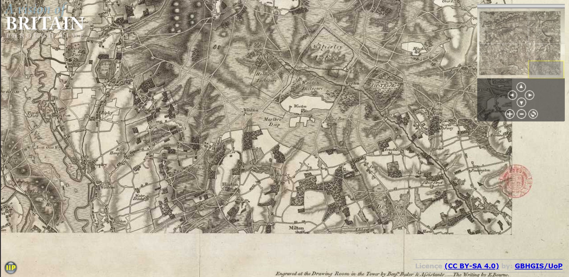
The owner of Hilton Admiral, and a significant amount of the local land, was George William Tapps Gervis (on the Tithe Apportionment) at the time of the Tithe Maps. More formally known as Sir George William Tapps-Gervis, 2nd Baronet (24 May 1795 – 26 August 1842). His father Sir George Ivison Tapps, 1st Baronet (5 January 1753 – 15 March 1835) was a British landowner and developer involved in the founding of Bournemouth. Tapps inherited some of the estates, including Hinton Admiral, which formerly belonged to Sir Peter Mews of Hinton Admiral, from his cousin, Joseph Jarvis Clerke, when the latter died without issue in 1778. In so doing he became Lord of the Manors of Hinton Admiral, Christchurch and Westover. He was also appointed High Sheriff of Hampshire in 1793. In the wake of the Christchurch Inclosure Act 1802, Tapps purchased 205 acres (0.83 km2) in what is now the borough of Bournemouth for 1,000 guineas (£1,050). As lord of the manor he was also trustee for the areas set aside as common land, for cottage dwellers to dig for turf and suchlike.
Interestingly, despite having the name of the landowner of Hilton Admiral, I am having problems finding the correct Tithe Apportionment and Map. Searching the whole of Hampshire provides over 700 results for George William Tapps Gervis, mainly in the parish of Christchurch, which was still in Hampshire at that time. Was the New Forest exempt from the Tithe Apportionment process, as a Royal Forest.
Not finding the correct Tithe Map impacted on the ability to find detailed location information about Thomas Tilley.
Tilley family emigrated to Australia
Tilley family emigrated to Australia
Tilley family emigrated to Australia during the 1850's
A large number of the Tilley family emigrated to Australia and it seems they may have been persuaded so to do by Charles Tilley who was then residing in Sydney, a person often mentioned in the passenger records. This mass movement also shares a timeline with the Sydney Gold Rush. Some of the passenger records were annotated £4 Remit Regs which may refer to Persons Proceeding to the Colony under Remittance Regulations as part of Economic Growth stimulus.
| Arrival date | Immigration date | Ship | Name | Gender | Marriage | Birth | Age | Occupation | Residence | Religion | Parents | P Residence | Read/Write | Relative in Colony | R Residence | Notes |
| 20 May 1850 | 22 May 1850 | Thetis | Charles Tilley | S | 25 | Farm Labourer | Christchurch, Hampshire | Independent | Thomas & Patience | Hinton, Hampshire | Both | None | ||||
| 20 May 1850 | 22 May 1850 | Thetis | John Purchase | M | M | 36 | Gardener | Milton, Hampshire | Independent | Richard & Elizabeth | Christchurch, Hampshire | Both | None | |||
| 20 May 1850 | 22 May 1850 | Thetis | Elizabeth Purchase | F | M | 32 | Wife | Waterditch, Hampshire | Independent | Thomas & Patience Tilley | Hinton, Hampshire | Both | None | |||
| 21 Jun 1854 | Switzerland | Peter Tilley | S | 1834 | 20 | Agricultural Labourer | Christchurch, Hampshire | Thomas & Harriet | Christchurch, Hampshire | Both | An uncle Charley Tilley | Sydney | ||||
| 21 Jun 1854 | Switzerland | Aaron Tilley | S | 1836 | 18 | Agricultural Labourer | Christchurch, Hampshire | Thomas & Harriet | Christchurch, Hampshire | Both | An uncle Charley Tilley | Sydney | ||||
|
3 Sep 1854 |
Tantivy | Thomas Fripp | M | M | 44 | Farm Labourer | Milton, Hampshire | Independent | Thomas & Betty | Milton, Hampshire | Neither | |||||
| 3 Sep 1854 | Tantivy | Sarah Fripp | F | M | 46 | Wife | Christchurch, Hampshire | Independent | Thomas & Patience Tilley | Hinton, Hampshire | Both | A Brother and Sister, Charles Tilley and Elizabeth Purchase | Balmain | |||
| 3 Sep 1854 | Tantivy | Ely Fripp | M | 17 | Farm Labourer | Christchurch, Hampshire | Independent | On Board | Both | |||||||
| 3 Sep 1854 | Tantivy | Henry Fripp | M | 15 | Farm Labourer | Christchurch, Hampshire | Independent | On Board | Both | |||||||
| 3 Sep 1854 | Tantivy | Ruth Fripp | F | 13 | Daughter | Milton, Hampshire | Independent | On Board | Both | |||||||
| 3 Sep 1854 | Tantivy | Edward Fripp | M | 9 | Son | Milton, Hampshire | Independent | On Board | Both | |||||||
| 3 Sep 1854 | Tantivy | Frank Fripp | M | 7 | Son | Milton, Hampshire | Independent | On Board | Read | |||||||
| 3 Sep 1854 | Tantivy | Charles Fripp | M | 3 | Son | Milton, Hampshire | Independent | On Board | Neither | |||||||
| 25 Feb 1855 | 2 Mar 1855 | Ascendant | Moses Lawrence | M | S | 17 | Farm Labourer | Hinton, Hampshire | Discenter | George & Ann | Hinton, Hampshire | Yes | An uncle John Purchess | |||
| 5 Aug 1855 | 8 Aug 1855 | Euphrates | Thomas Tilley | M | 1806 | 49 | Agricultural Labourer | Christchurch, Hampshire | Independent | Thomas & Patience | Hinton, Hampshire | No | A Brother Chas | Balmain | ||
| 5 Aug 1855 | 8 Aug 1855 | Euphrates | Harriet Tilley | M | 44 | Wife | Christchurch, Hampshire | Independent | John & Sarah White | Dead | Both | Two sons Peter and Aaron | Balmain | |||
| 5 Aug 1855 | 8 Aug 1855 | Euphrates | Sarah | S | 15 | Domestic Servant | Christchurch, Hampshire | Independent | On Board | Both | ||||||
| 5 Aug 1855 | 8 Aug 1855 | Euphrates | S | 9 | DaughterAscend | Christchurch, Hampshire | Independent | On Board | No | |||||||
| 5 Aug 1855 | 8 Aug 1855 | Euphrates | Elizabeth | S | 5 | Daughter | Christchurch, Hampshire | Independent | On Board | No | ||||||
ESRI Migration Map
Under development Migration map
This will change
more later
1900s
The 20th Century
Your text...
Conclusion
ESRI Migration Map
Under development Migration map
This will change
more later