89 Grove Street, Southampton
Where is Grove Street?
It is in the Chapel area or St. Mary's area of what was the town of Southampton, Hampshire, England.
The Sotonpedia entry is;
Grove Street and Grove Court
Grove Street
Runs south/north from Chapel Road to Bevois Street in St Mary’s. It is part of the traditional road from Hamwic to Northam, though its predecessor, Golden Grove, followed a slightly different course.
Grove Street Cottages
In the 19th century these cottages were situated on the west side of Grove Street, south of Bevois Street.
Grove Court
A 19th century Court in Grove Street, on the west side to the north of James Street.
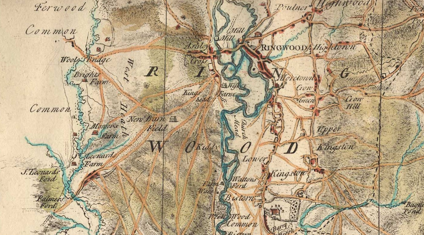
Hamwic and Hamtun
The Saxon settlement at Southampton was known either as Hamwic or Hamtun (variant spellings include Hamwih, Hamwich and Hamton, Hampton). The former signifies a trading centre, the latter applying to the settlement in its administrative function.
The two names co-existed throughout the Anglo-Saxon period. Hamwic survived as a name until the 11th century. Hamtun survived and evolved into Southampton. The first reference to Southampton was in the Anglo-Saxon Chronicle of 980 but the name did not become common until the 12th century. Hamtun was an alternative name for the town until the 17th century.
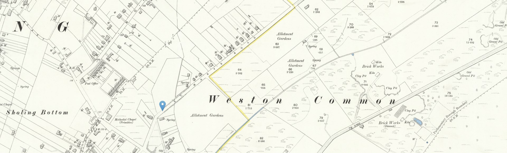
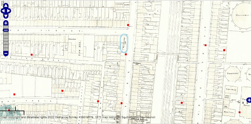
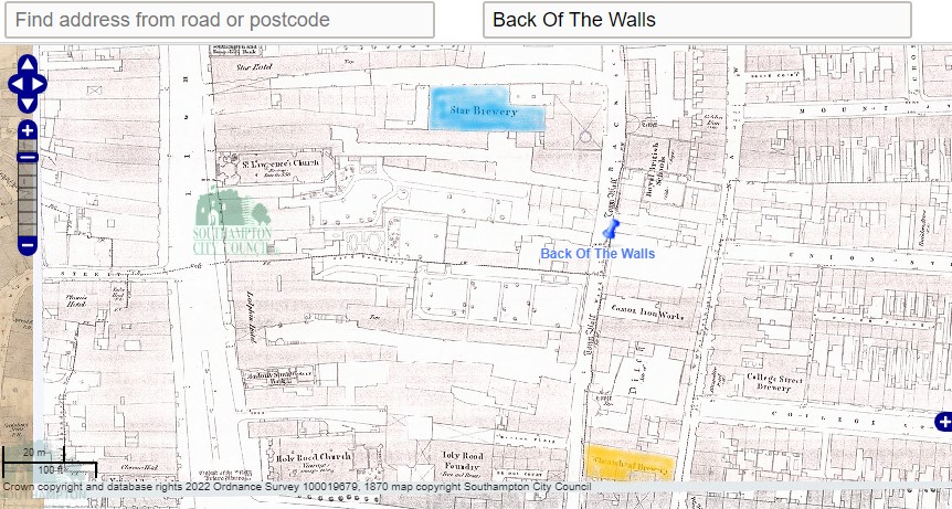
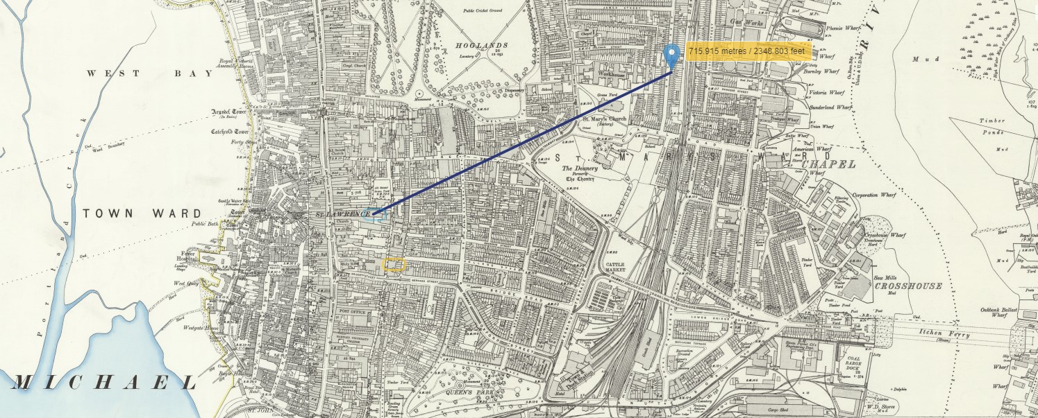
Grove Street can be found on an 1870 OS Map held and hosted by Southampton City Council .
Click the map to go to the source.

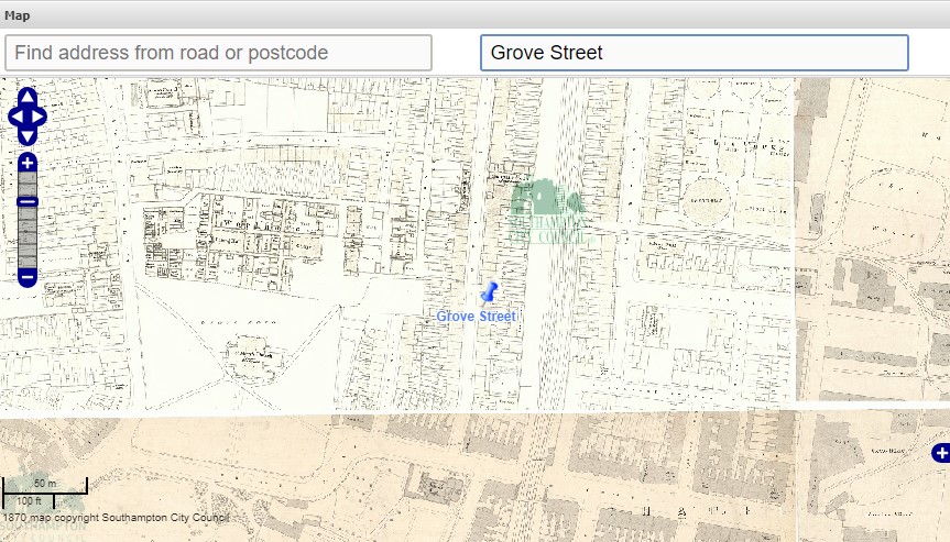
Another Ordnance Survey Map, held and hosted by the National Library of Scotland. The marker may be the location of 89 and 90 Grove Street, and the plot measurement is about the same as on the lease. I recall being told that 89 Grove Street backed on to the railway. The pattern of the houses footprint suggest that it maybe this pair of houses.
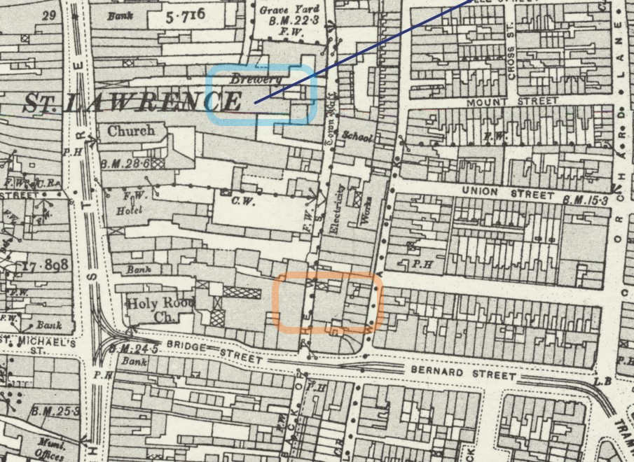
On the map, nearly opposite the marker, you can see the Almshouses. Sotonopedia has an article containing information about them, of which there is an extract below, together with one of the two photos.
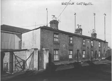
Grove Street Almshouses
In 1830 the St Mary’s site was acquired by the Poor Law Guardians for the new workhouse. In return the Guardians supplied a site in Grove Street on which seven new almshouses were built in 1831 (image 1 below). On the wall between numbers 1 and 2 was set a stone tablet which had originally been placed on the front of Butler’s Almshouses in 1565 (image 2 below). The stone tablet had a carving of three roses, the date 1565 and initials R.B. (Richard Butler). These almshouses, later renamed Norfolk Cottages, survived until c.1960.
WW2 Bomb damage
Extract of list of 'Photographs of War Damaged Properties' from The National Archives
60 a-c 13, 14 & 15 Grove Street, 1947.
61 a-b 17 Grove Street, (front and rear), 1947.
62 a-c 20-25 Grove Street (front and rear), 1948.
63 a-b 40½ Grove Street, 1948.
64 a-c 54, 55 & 56 Grove Street, 1948.
65 a-d 82-87 Grove Street (front and rear), 1947.
66 a-b "Royal Exchange" P.H. Grove Street, 1948.
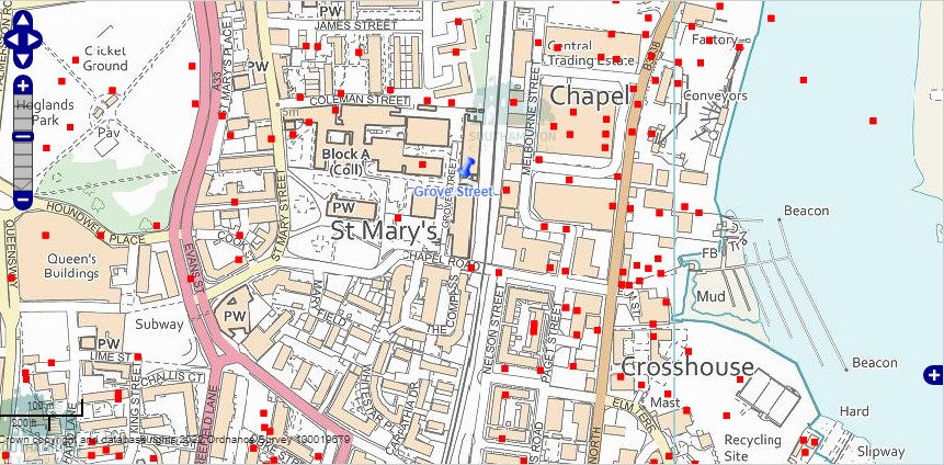
The above map is current with superimposed WW2 recorded bomb sites. The area was heavily bombed during WW2. There is still a Grove Street according to this map, but not as long as it used to be. The whole are has been redeveloped. I recall my Mum telling me about the crater at the end of the road, by the level crossing. I suspect that was the one shown between the A and D of the label Chapel Road on the map. Walking with her Mum, past the bomb crater in wellies, then changing into school shoes, for the rest of the short walk to school.
Back to the 1870 map of Grove Street, but with the WW2 bomb sites layer added. Three in this section of Grove Street, all the other side of the road from no. 89. The Royal Exchange Public House, mentioned in the list of photographs of bomb damage properties, is circled in blue. The list appears to have more instances than the map.
A photo posted in Flickr by Robert Fish reproduced here with his kind permission.
Robert's comment plus one other
Its actually in Grove Street, just off Chapel Road, looking at OS maps these were pulled down between 1968 and 1971. In the last few months there has been an Archaeological dig within Southampton City College (in the area of these houses) and they have turned up a number of Middle Saxon Houses (3 at the last count) which have not been damaged by ploughing. The site lies near the southern edge of the Middle Saxon town of Hamwic. Photo's from the dig, and of the very deep brick build drainage pipes will be posted soon in my photo stream.
Pete Lamb
The houses were demolished too make way for the Itchen Bridge (ha ha). The final design of the bridge went no-where near here.
A lot of TITANIC crew lived in these closely knit roads.
Table constructed by reference to Encyclopedia Titanica
| Name | Age | Address | From ship | Job |
|---|---|---|---|---|
| George Phillips | 27 | 5 Grove Street | Olympic | Greaser |
| W. Light | 47 | 25 Grove Street | Olympic | Fireman |
| Frank Terrell | 26 | 5 Grove Street | Oceanic | 2nd Class Steward |
| A. Manly | 23 | 5 Grove Street | Oceanic | 3rd Class Steward |
| Albert Haines | 30 | 53 or 62 Grove Street | Olympic | Boatswain Mate |
| William Henry Dyer | 33 | 68 Grove Street (1911 Census) | Olympic | 1st Class Steward |
| Walter Hurst | 27 | 13 Chapel Road | Olympic | Fireman |
| William Mintram | 46 | 15 Chapel Road | Oceanic | Fireman |
The table is not necessarily a complete list of those with Grove Street connections. Some of the people perished in the tragedy, and some survived, but one missed the sailing, having previously signed on to the crew.
I have added Walter Hurst and William Mintram to the table as Chapel Road is at the end of Grove Street, but more importantly, because they are both in my Family Tree and there is an article about them and a murder.
Apparently about 500 of the crew of the Titanic were Sotonians and 1/3 of all the passengers and crew who were lost on that fateful day of 15 April 1912 were from Southampton.
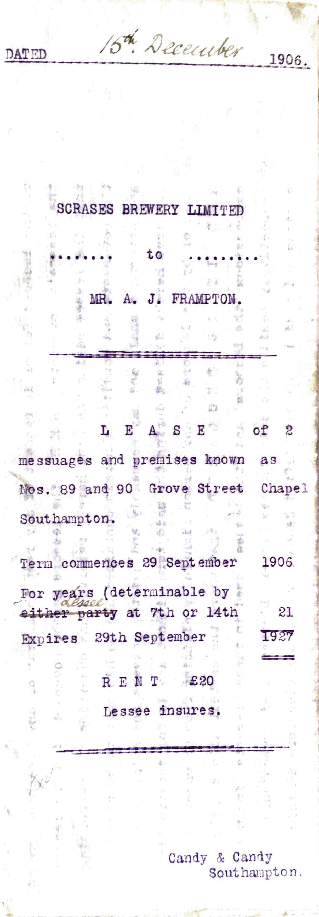
Lease
Alfred James Frampton was born about 1841 in Southampton, Hampshire, England to parents George and Amelia.
Our story does not start there however.
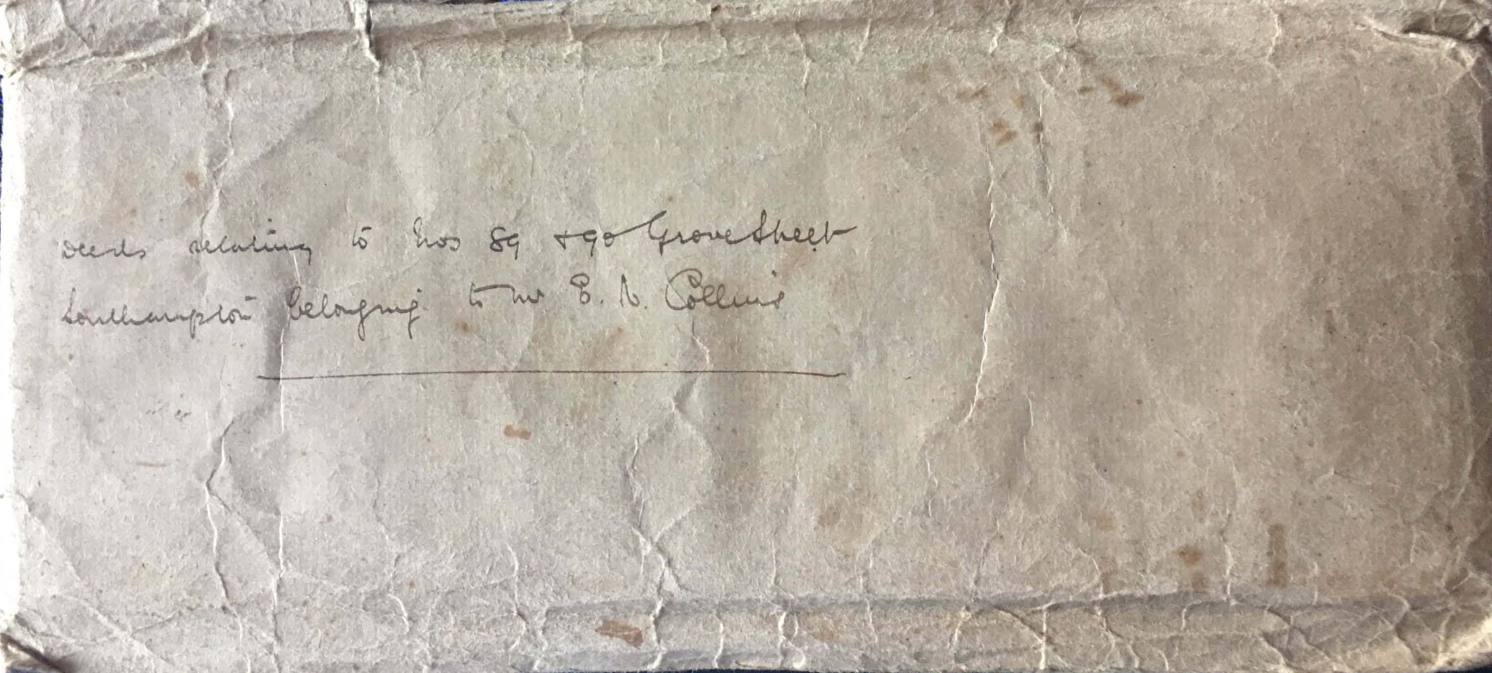
Looking through some old documents at home I found a deeds envelope with 'Deeds relating to Nos 89 & 90 Grove Street Southampton belonging to Mr E N Collins'. What a find, as you can see below.
Lease of 2 messuages and premises known as Nos. 89 and 90 Grove Street Chapel Southampton.
![]() Lease 89-90 Grove Street 1906524.34 KB17/03/2022, 18:32
Lease 89-90 Grove Street 1906524.34 KB17/03/2022, 18:32
Click the link to read the full lease.
The next document is the consent given by the Lessor, Scrase's Brewery Limited to the Executors of the Will of Mr. Alfred James Frampton, Messrs, Frank Kimber and George Willis.
![]() Consent 89 Grove Street 1915 Typewritten376.54 KB18/03/2022, 18:42
Consent 89 Grove Street 1915 Typewritten376.54 KB18/03/2022, 18:42
Below is the resultant Assignment to Edward Nash Collins, of 39 Grove Street Southampton
![]() Indenture 89 Grove Street 1915 Handwritten684.29 KB18/03/2022, 17:46
Indenture 89 Grove Street 1915 Handwritten684.29 KB18/03/2022, 17:46
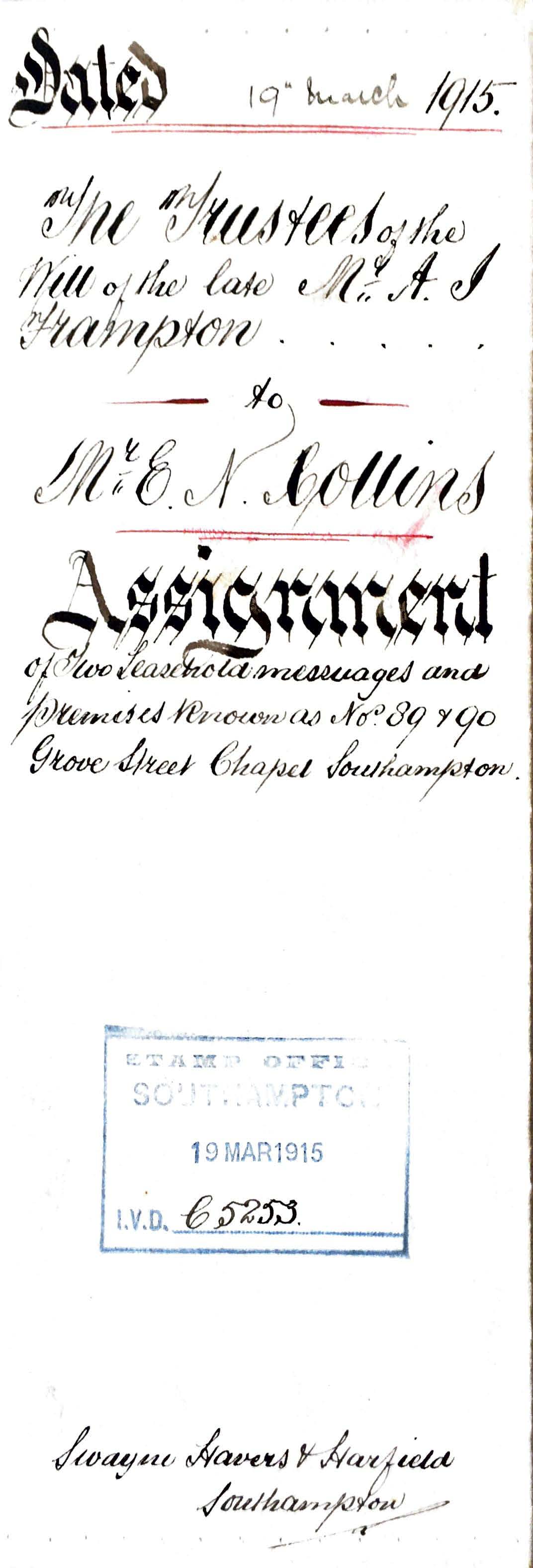
Just admire the penmanship. The scan does not do it full justice.
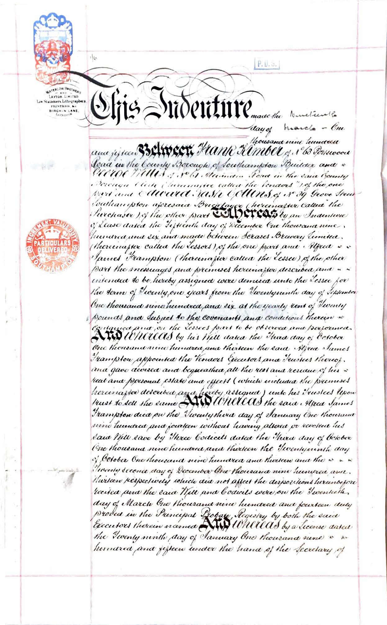
To read the full document click the link to the pdf file above.
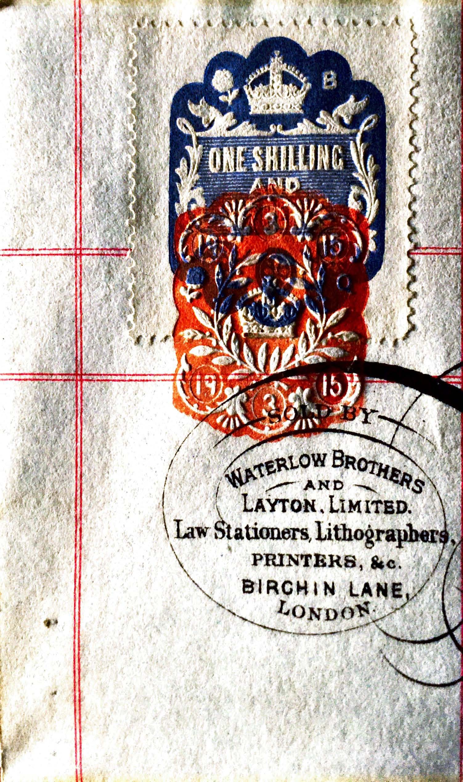
Two more things before we leave this document, the first, a better image of the stamp with a value of one shilling and six pence, and the embossed date stamp indicating March 1915. Stamp duty at one shilling and six pence, which is only 71/2p when converted, plus inflation.
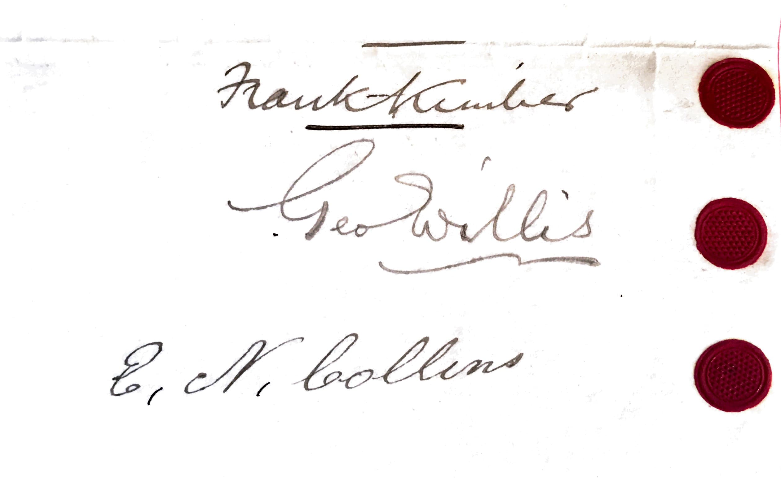
Secondly, a close up of the signatures of the parties, including of course Edward Nash Collins, of No 39 Grove Street Southampton, a bricklayer.
Scrase's Brewery
This brewery, also known as the Star Brewery, formerly stood on the west side of Back-of-the-Walls at the east end of the Star Hotel yard. The business was started by Alderman Scrace in the mid 19th century. In 1890 the business was extended through purchase of the Wheatsheaf Brewery at the rear of the Wheatsheaf Hotel in Bridge Street. The brewery was taken over by Strong’s of Romsey in the 1920s.
Scrase's Brewery Ltd, Star Brewery, Upper Back of Walls, 29 High Street, Southampton, Hampshire.
Founded 1829.
Registered November 1889 to acquire Henry Scrase.
Acquired by Strong & Co Ltd. 1927 with over 97 houses and brewing ceased 1947.
Maltings were at the rear.
List of Scrase's owned pubs in Grove Street.
Apollo Inn, Grove Street, Southampton (ex- Henry Welsh, Wheatsheaf Brewery, Southampton)
Southampton Transport Workers’ Social Club, Grove Street, Southampton.
Star Inn, Grove Street, Southampton (closed 1905)
Rink Tavern, formerly Cabman’s Arms, Grove Street, Southampton was purchased in 1892 from Henry John Panton & Co, Wareham, Dorset.
The site of Scrase's Star Brewery, washed in blue, together with Wheatsheaf Brewery washed in orange.
Below, approximately 800 yards between Star Brewery and 89 Grove Street
Zoomed in on the two breweries, the Star and the Wheatsheaf.
Apollo
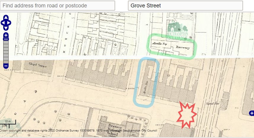
At the Chapel Road end of Grove Street there is an Apollo Inn, on 13 Chapel Road, circled in blue. Apollo Tap and Brewery circled in green. An early thought was that the Brewery was the one referred to in the original lease of 1906, but that is not the case.
Note the Deanery National School at the bottom of the map, the level crossing, and by reference to the WW2 Bomb Map, the crater between the two. The crater could have been closer to the road junction or Apollo Inn.
Census
Edward Collins was resident at 89 Grove Street for the 1911 Census. This was to be expected as he was referred to as 'the present tenants of the said property under the Lease. hereinafter mentioned to Mr. Edward Nash Collins of No. · 89, Grove Street, Saint Marys, Southampton of the hereditaments and premises comprised in an Indenture of Lease dated the 15th. day of December One thousand nine hundred and six and made between Scrase's Brewery Limited of the one part and the said Alfred James Frampton' within the consent document above.
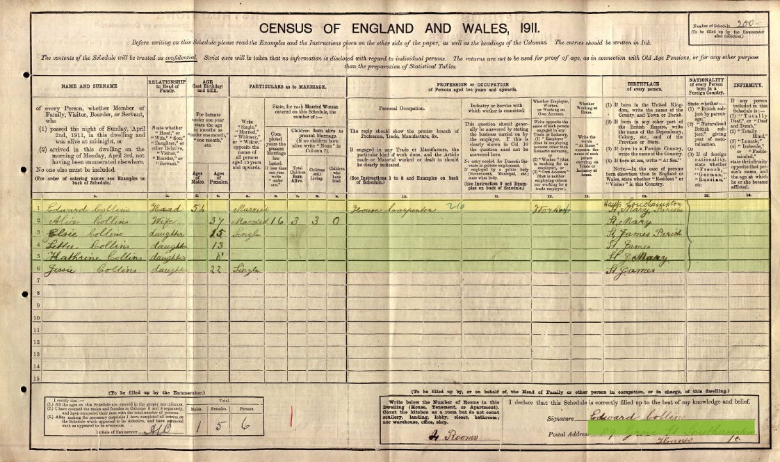
Edward Collins is living at 89 Grove Street with his family
| Name and Surname | Relation to Head | Condition | Age last birthday | Estimated Birth Year | Gender | Years married | Children born | Children still alive | Children who have died | Occupation | Employer / worker | Working at home | Where Born |
| Edward Collins | Head | Widow | 54 | 1857 | Male | House Carpenter | Worker | St Mary's, Hampshire, England | |||||
| Alice Collins |
Wife
|
Single | 37 | 1874 | Female | 16 | 3 | 3 | 0 | St Mary's, Hampshire, England | |||
| Elsie Collins |
Daughter
|
Single | 15 | 1896 | Female | St James | |||||||
| Letitia Collins |
Daughter
|
Single | 13 | 1898 | Female | St James | |||||||
| Kathrine Collins | Daughter | Single | 8 | 1903 | Female | St Mary's | |||||||
| Jessie Collins |
Daughter
|
Single | 22 | 1889 | Female | St James |
Jessie Collins was a daughter to Edward by a previous marriage, and therefore not counted in Alice's children data.
The 1901 Census, Parish of St Mary's, District 35
Does this change things? Zoom in for a closer look.
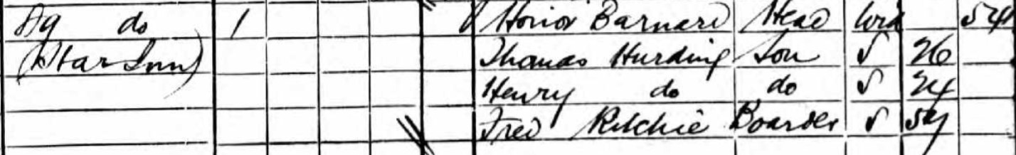
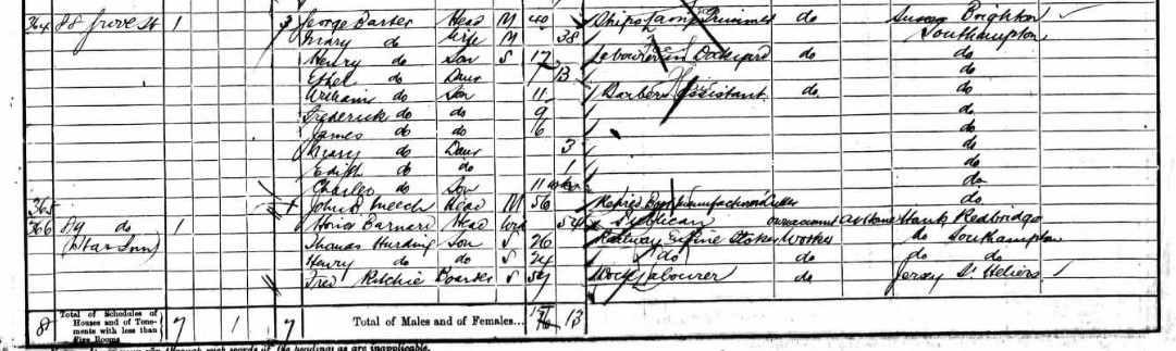
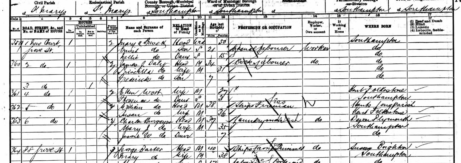
89 Grove Street is the Star Inn in 1901.
According to the List of Scrase's owned pubs in Grove Street above, the Star in was closed in 1905. This makes sense with the lease of Nos. 89 and 90 Grove Street Chapel Southampton to Alfred James Frampton in 1906.
| Name and Surname | Relation to Head | Condition | Age last birthday | Estimated Birth Year | Gender | Occupation | Employer / worker | Working at home | Where Born |
| Honor Barnard | Head | Widow | 54 | 1847 | Female | Publican | Own account | At home | Redbridge, Hampshire, England |
| Thomas Hurding | Son | Single | 26 | 1875 | Male | Railway Engine Stoker | Worker | Southampton, Hampshire, England | |
| Henry Hurding | Son | Single | 24 | 1877 | Male | Railway Engine Stoker | Worker | Southampton, Hampshire, England | |
| Fred Ritchie | Boarder | Single | 57 | 1844 | Male | Dock Labourer | Worker | St Helens, Jersey, Channel Islands | |
The 1891 Census, Parish of St Mary's, District 35
There is mention of a School House near 65 Grove Street.
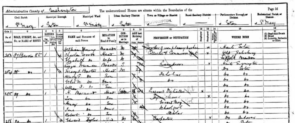
The Census states 87 Bevois St at the top of the page, which would make 89, Bevois Street as well. However, Bevois Street is to the north of Grove Street and was the first part of the District 35 walk. That part of the walk covers Bevois Street to the Railway Gates on both sides, nos. 1 to 49, odds and evens, then a gap followed by 92 to 143. Then Grove Street. The page above is flanked by Grove Street entries. District 37 has Bevois Street East of the Railway Gates. Nos 51 to 90, odds and evens, including 89, in District 37. I assume the building of the railway resulted in the demolition of nos. 50 and 91. It had a different family in 89 Bevois Street in District 37, I therefore conclude that the above 89 Bevois Street is in fact 89 Grove Street, the Star Inn from the 1901 Census, with the same family in both 1901 and 1891,
| Name and Surname | Relation to Head | Condition | Age last birthday | Estimated Birth Year | Gender | Occupation | Employer / worker | Neither | Where Born |
| H Barnard | Head | Widow | 43 | 1848 | Female | Licensed Victualler | Employer | Southampton, Hampshire, England | |
| Tom Barnard | Son | Single | 16 | 1875 | Male | Engine cleaner | Worker | Southampton, Hampshire, England | |
|
Henry Barnard
|
Son | Single | 15 | 1876 | Male | Errand boy | Southampton, Hampshire, England | ||
| Jane Barnard | Daughter | Single | 11 | 1880 | Female | School girl | Southampton, Hampshire, England | ||
| Robert Barnard | Son | Single | 9 | 1882 | Male | Scholar | Southampton, Hampshire, England |
I suspect this is the same family as in the 1901 Census, but the surnames of Tom and Henry don't match.
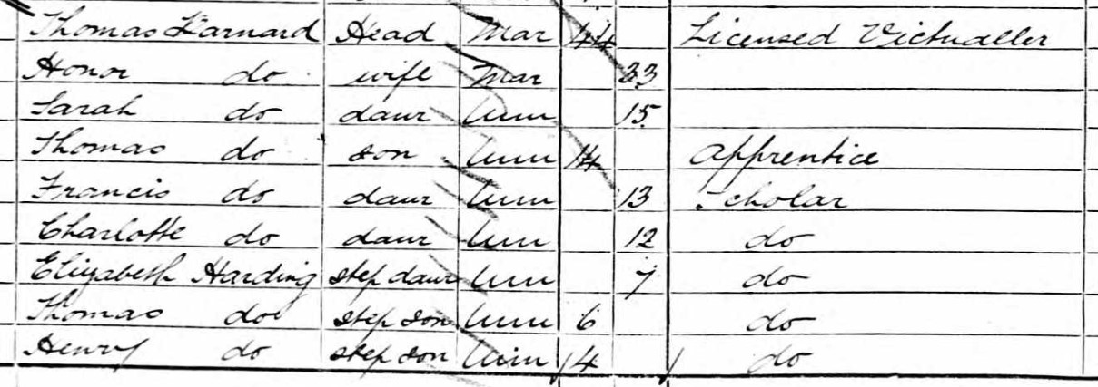
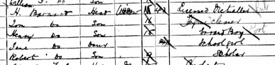
On the 1881 Census Honor Barnard has a husband, Thomas Barnard, and they are living with their family at 55 Bevois Street, St Mary, Southampton, Hampshire, England, Thomas Harding, 6 and Henry Harding 4, are step-sons of Thomas Barnard, and Elizabeth Harding 7 is his step-daughter. Sarah 15, Francis 13, and Charlotte 12 are his daughters, and Thomas, 14 his son, presumably from a previous marriage. That therefore makes sense with the 1901 Census having different surnames. Although, I can fully see why the transcriber went with Hurding instead of Harding as the 1881 image clearly shows.
According to the 1911 Census Honor Barnard was a Boarding House Keeper living at 34 Terminus Terrace, St Mary's, Southampton, Hampshire, England. She was living with two of her sons, Henry Hurding 34 and Robert Ernest Barnard 29.
Honor Hurding married Thomas Barnard in 1882 according to the marriage register, a year after they stated they were married on the 1881 Census. Honor Barnard died in 1927 at the age of 80, in Southampton. Was the surname Harding or Hurding. It is clearly both according to the Census papers, but the marriage register, if the same people, has Hurding.
A Honor Anteney married a Thomas Hurding on 10 March 1872, when she was 25 at Millbrook, Hampshire. Thomas Hurding died at the young age of 31 in 1878 leaving Mrs Honor Hurding a widow, able to marry Thomas Barnard in 1881/82.
The 1881 Census, Parish of St Mary's, District 23.
There is an enumerators note regarding the health of this District.
'The Health of the inhabitants of my district appeared to be extremely good. Only one slight case of disease among children having been met with, and that was chicken pox.'
For the 1881 Census the enumerator's walk starts at 1 Grove Street. Nos. are both odd and even. Between nos. 25 and 26 are the Alms Houses shown on the map on the West side of Grove Street.
Goddards Court, 1 to 6, is between nos. 42 and 43 Grove Street.
Grove Street School house is recorded between nos. 69 and 70.
New Court, 1 to 6, is between nos. 87 and 88 Grove Street.
Grove Street ends at no. 96 and the Census Record moves on to Church Street. I have yet to identify the location of Church Street as the roads at either end of Grove Street are Bevois Street to the North and Chapel Road to the South. Only one road off Grove Street and that is James Street. After Church Street in the Census Record is Western Terrace, Chapel Road. Which is at the southern end of Grove Street.
No 89 Grove Street has a family of three in residence.
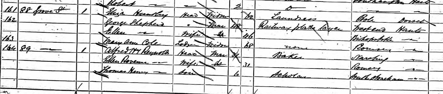
| Name and Surname | Relation to Head | Condition | Age last birthday | Estimated Birth Year | Gender | Occupation | Where Born |
| Alfred H. T. Reynolds | Head | Married | 31 | 1850 | Male | Baker | Nursling, Hampshire, England |
| Ellen Rowenna Reynolds | Wife | Married | 31 | 1850 | Female | Romsey, Hampshire, England | |
| Thomas Henry Reynolds | Son | Single | 6 | 1876 | Male | Scholar | South Stoneham, Hampshire, England |
An aside. Nothing to do with 89 Grove Street other than the close proximity.
Ann Pomeroy residing at 4 New Court, just a few doors away from 89 Grove Street. Ann, a widow, 55 (1826), from Bridport, Dorset, living with her 17 year old (1864) son born in Freemantle, Hampshire, which is now a suburb of Southampton.
A Pomeroy married a Collins, at a later time, but that is a different story.
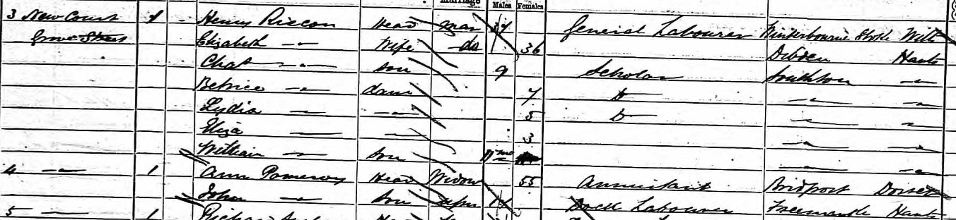
Courts off Grove Street.
Tucker's Court, a 19th century court in Grove Street. Appears to be between James Street and Bevois Street, on the West side of Grove Street form the OS 1870 Map.
The 1871 Census, Parish of St Mary's, District 20.
| Name and Surname | Relation to Head | Condition | Age last birthday | Estimated Birth Year | Gender | Occupation | Where Born |
| Robert Abree | Head | Married | 54 | 1817 | Male | Baker & beer retailer | Southampton, Hampshire, England |
| Martha Abree | Wife | Married | 37 | 1834 | Female | Southampton, Hampshire, England | |
| James E Hiscock | Son-in-law | Single | 18 | 1853 | Male | Paper hanger | Southampton, Hampshire, England |
| George F Hiscock | Son-in-law | Single | 12 | 1859 | Male | Scholar | Southampton, Hampshire, England |
| Lizzie M Hiscock | Daughter-in-law | Single | 11 | 1860 | Female | Scholar | Southampton, Hampshire, England |
Robert Abree is also listed in in 1878 White´s History, Gazetteer and Directory, as a Baker and Beerhouse at 89 Grove Street, Southampton. He also appears as a voter in the Election of 12th July 1865, residing in Grove Street. Martha Abree, nee Ingram was previously married to Edward William Hiscock on 14 Dec 1851 at Southampton, Hampshire, England. They had four known children together, with three surviving in the 1871 Census. Edward William Hiscock died about 1865. Matha subsequently married Robert Abree, although I have yet to confirm this with a record.
The 1861 Census, Parish of St Mary's, District 18.
The numbering of Grove Street according to the 1861 Census Record
Tucker's Court, Grove Street; 1, 2, 3, 4, 5.
Goddard's Buildings Grove Street; 1, 2, 3, 4, 5, 6.
Grove Street; 1, 2, 3, 4, 5, 6, 7, 8, 9, 10 Somerset Arms, 11, 13, 14, 15.
Grove Street; 109 The United ??
Grove Street; 1, 2, 3, 4a, 5, 6, 7, 8, 9, 10, 11, 12, 13, 14, 15, 16, 17, 18, 19, 20, 21, 22, 23, 24, 25
Alms Houses Grove Street; 1, 2, 3, 4.
Grove Street; 27, 28, 29, 30, 31, 32, 33, 34, 35, 36, 37, 38, 39, 40, 41, 42, 43.
Grove Street; 1 Apollo Tap, 2, 3, 4, 5, 6, 7, 8, 9.
New Court Grove Street; 1, 2, 3, 4, 5, 6.
Grove Street; 10, 11, 12, 13, 14, 15, 16, 17, 18, 19, 20, 21, 22, 23, 24, 25, 26a, 27.
Grove Street; St Mary's National School House
Grove Street; 97, 96, 99, 100, 101, 102, 103, 104, 105, 106, 107, 108.
A very strange numbering system measured against today's norms, with at least three No 1 Grove Street, as an example.
Previous experiences suggest that sometimes it is a case of a row of houses, or terrace numbered 1 to ?? and this is then repeated in another terrace.
A similar pattern occurs in the previous 1851 Census below.
Given the different numbering system, and no reference Star Inn, there appears no way to be able to identify the particular property later identified as No 89 Grove Street.. The occupants of no 89 Grove Street in the 1871 Census are to be found elsewhere in earlier Census, so even the names do not give a hint of the location.
The 1851 Census, Parish of St Mary's, District 1o.
The numbering of Grove Street according to the 1851 Census Record
Grove Street; 1, 2, 3, 4, 5, 6, 7, 8, 9, 10, 11, 12, 13, 14, 15, 16, 17, 18, 19, 20, 21, 22, 23, 24, 25
Alms Houses Grove Street; 1, 2, 3, 4.
Grove Street; 27, 28, 29, 30, 31, 32, 33, 34, 35, 36, 37, 38, 39, 40, 41, 42.
Goddard's Buildings Grove Street; 1, 2, 3, 4, 5.
Tuckers Buildings Grove Street; 1, 2, 3, Unoccupied, 5
Grove Street; 1, 2, 3, 4, 6, 7, 8, 9.
New Court Grove Street; 1, 2, 3, 4, 5, 6.
Grove Street; 10, 11, 12, 13, 14, 15, 16, 17, 18, 19, 20, 21, 22, 23, 24, 25, 26, 27, Uninhabited.
Grove Street; 97, 98, 99, 100, 101, Uninhabited, 103, 104, 105, 106, 107, 108, 109.
Grove Street; 11, 10, 9, 8, 7, 6, 5, 4, 3, 2, 1.
Grove Street; 7,
A very strange numbering system measured against today's norms, with at least three No 1 Grove Street, as an example.
Previous experiences suggest that sometimes it is a case of a row of houses, or terrace numbered 1 to ?? and this is then repeated in another terrace.
Given the different numbering system, and no reference Star Inn, there appears no way to be able to identify the particular property later identified as No 89 Grove Street..
The 1841 Census, Parish of St Mary's, District 14.
The Census Record for Grove Street does not have house numbers. the Alms Houses are separately identified, but none of the courts or public houses until the Deanery on Chapel Road.
Tithe Apportionment and Map
The Tithe Apportionment is relatively late at 30th May 1851, compared to some of the others researched on this website. The Map is signed off by the Assistant Tithe Commissioner on 21st Sept 1852.
Normally that would provide a useful cross-reference to the Census of 1851. However, buildings don't produce crops or livestock, hence there is a lack of detail with the buildings being grouped into a large single plot, 477.
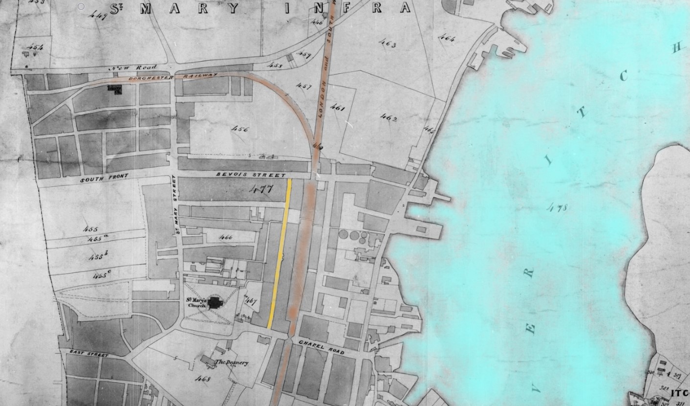
| Landowner Organisation | Town Portion of Saint Marys Infra |
|---|---|
| Parish | St Marys Extra, Southampton |
| County | Hampshire |
| Original Date | 30th May 1851 |
| Description of Land | Saint Mary's Infra, Buildings |
| Quantities In Statute Measure | 295,2,22 |
| Plot | 477 |
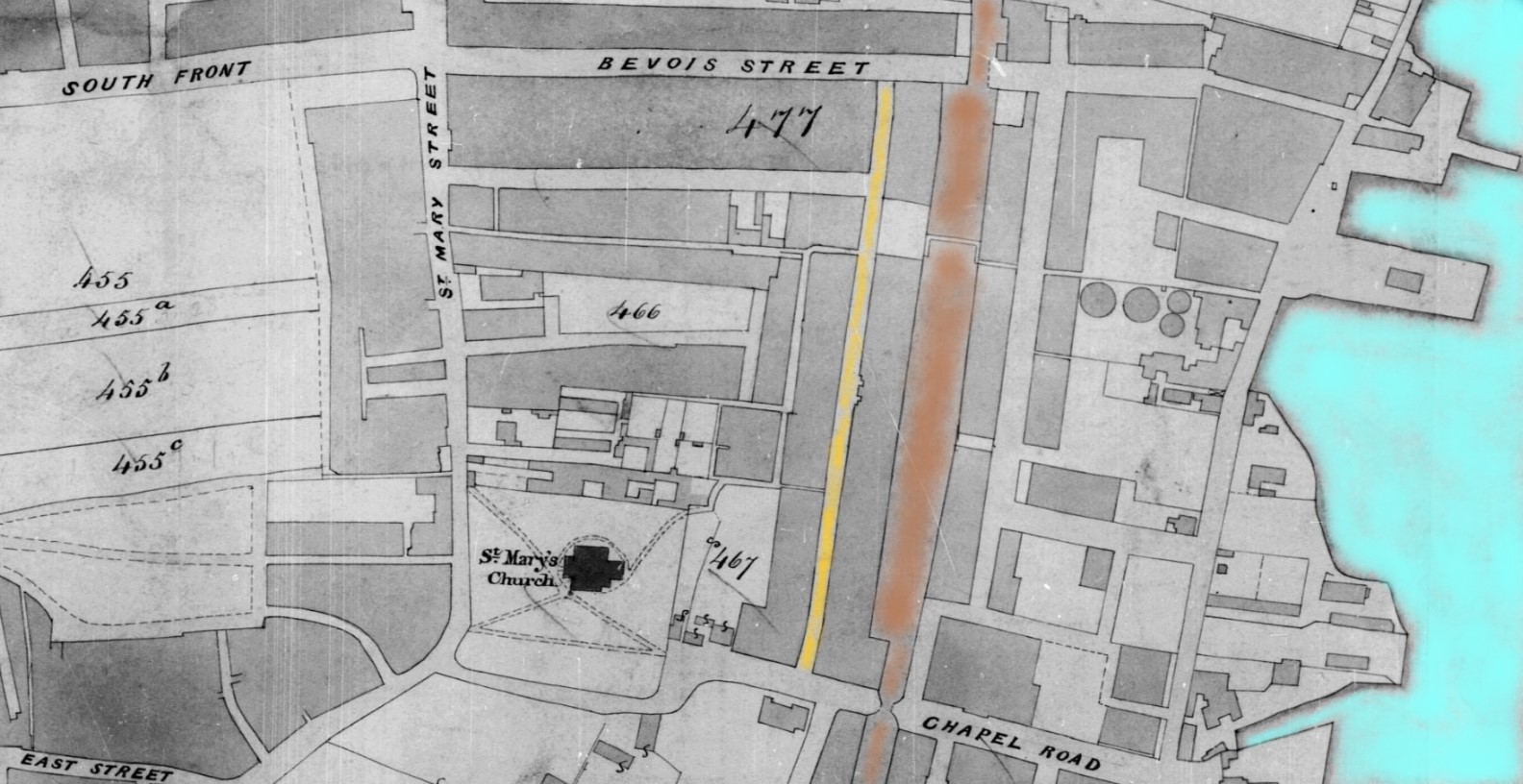
Within plot 477 is Grove Street, given a gold colour wash for easy identification. London and South Western Railway and Dorchester Railway are brown. I did think about using Malachite green, but that was more a later colour adopted by Southern Railway.
Locomotive liveries L&SWR
Liveries for painting of locomotives adopted by the successive Mechanical Engineers:
To 1850 (John Viret Gooch)
Little information is available although from 1844 dark green with red and white lining, black wheels and red buffer beams seems to have become standard.
1850–1866 (Joseph Hamilton Beattie)
Passenger classes – Indian red with black panelling inside white. Driving splashers and cylinders lined white. Black wheels, smokebox and chimney. Vermilion buffer beams and buff footplate interior.
Goods classes – unlined Indian red. Older engines painted black until 1859.
Southampton and Dorchester Railway
The Dorchester Railway shown near New Road did not last long as a separate company being amalgamated with LSWR in 1848.
Some of the roads are still identifiable today, and even part of Grove Street remains but the area has been redeveloped and repurposed. There is no evidence of 89 Grove Street now.
Enlightenment
I ordered a book online and it arrived today.
Southampton's Lost Streets St Mary and Golden Grove by Dave Marden
First published 2019 ISBN 978-1-78091-587-6
Chapter 2 of the book is entitled Grove Street and Bevois Street. It states that Grove Street and Bevois Street were two of the primary thoroughfares serving the area...
The author, David Marden apparently walked along Grove Street on his way to and from his Junior School.
He also recognises in the book the difficulties presented by the numbering system along the street having been changed several times. He does clarify that Grove Street retained its up and down numbers rather than switch to odds and evens.
Most of the buildings on the street were complete by the 1840's.
One of the great benefits of the book for me, apart from the general story telling, is the numbering of the houses along the street.
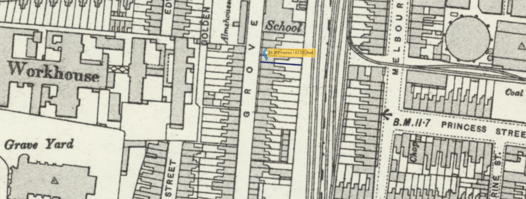
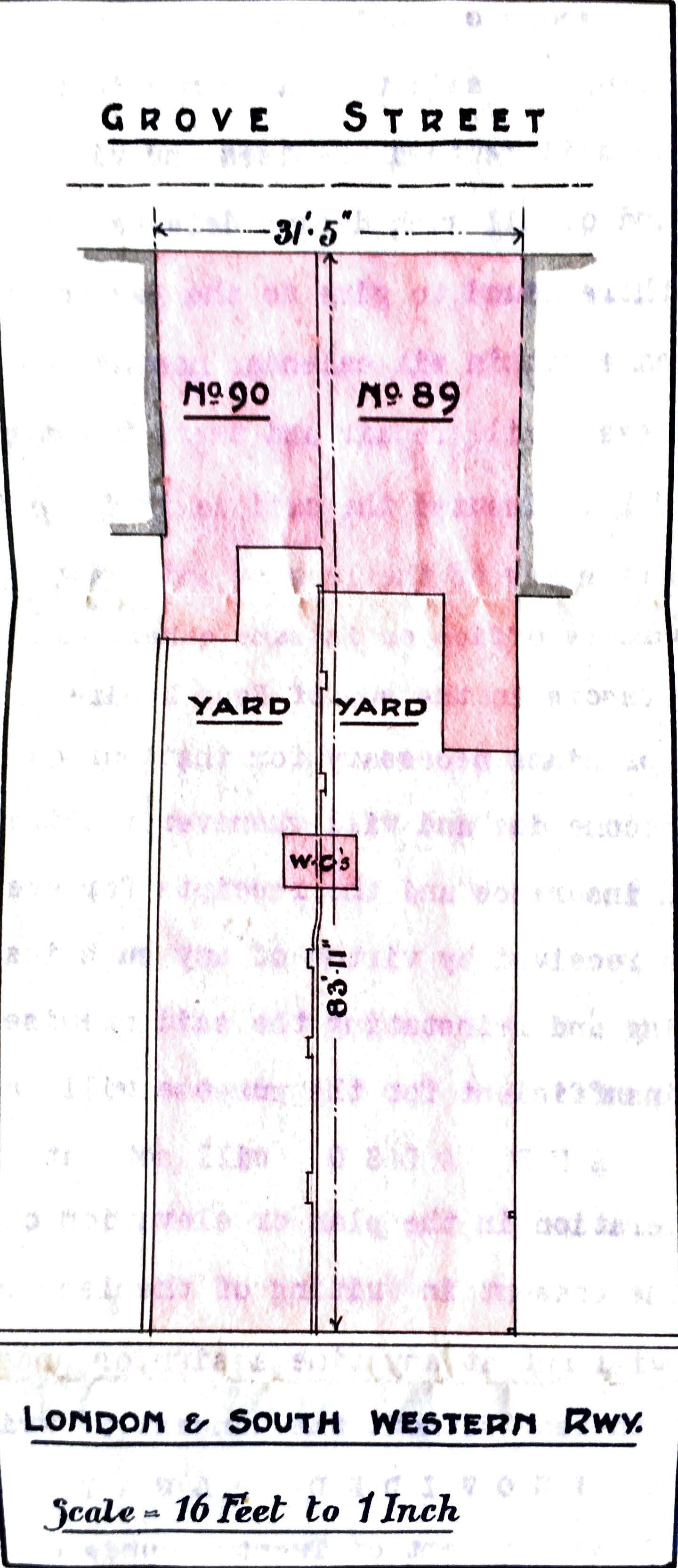
Going back a little, I used the layout or footprint of the plan included with the lease above. Both the two houses and the marks beside the plots which I assume to indicate the walls of the adjacent, and adjoining, walls. With this information, I tried to pattern match the outline of the house and size of the plot to match with the Southampton City 1870 map and secondly the OS 25" map, shown above.
I did look at the house that the book has annotated as number 89, but some elements matched the footprint, but others did not, so I continued looking for a better match. Surprisingly, there are not many of the houses with a similar pattern of in and out protrusions at the back of the houses.
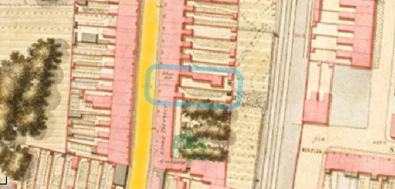 OS Map 1846 Southampton 89-90 Grove Street
Circled in blue is the 89-90 Grove Street based on the observations of the book. You can see from the map that in 1846 there is an extension in the back that is not on the lease plan in 1906, sixty years later. There is some writing on the map which could be Star Inn. It is not clear enough on the web version of the map to make out the letters. I think the houses with the trees in the back indicated on the 1846 Map are called Grove Terrace.
The same area but the 1870s map.
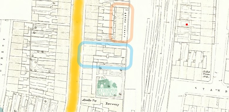 OS Map 1870 Southampton 89-90 Grove Street and New Court
The same pair of buildings circled in blue. the Star Inn was still open in 1870, but both the annotations shown on the 1846 map have been omitted from the 1870 map. The extension is still shown in the backyard of no. 89.
An addition to the 1870 map is a row of houses which appear to be annotated as James Court, but are otherwise known as New Court, circled in orange.
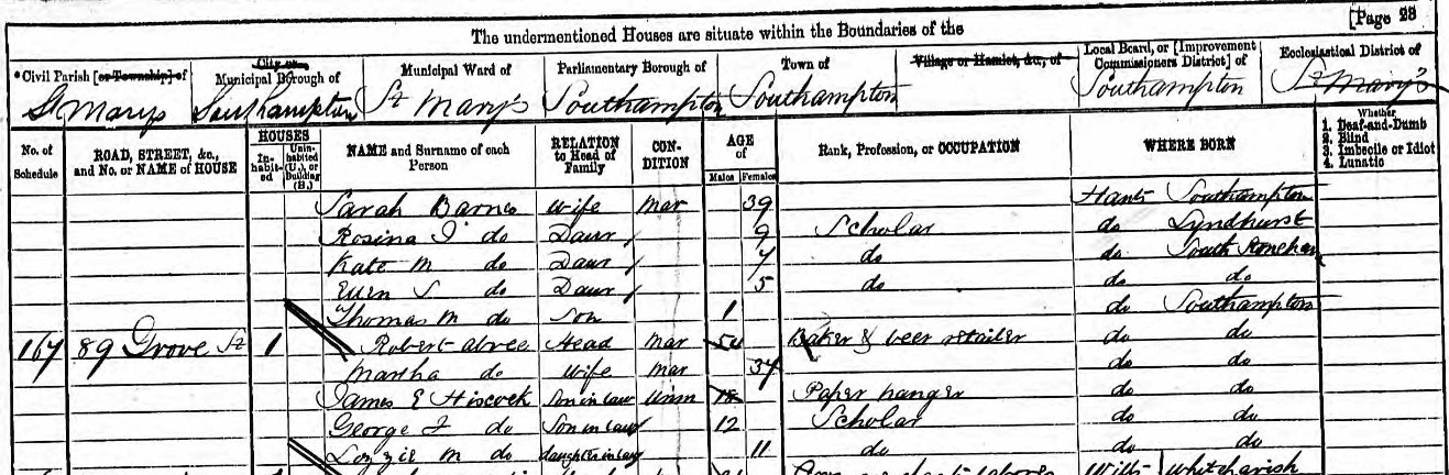
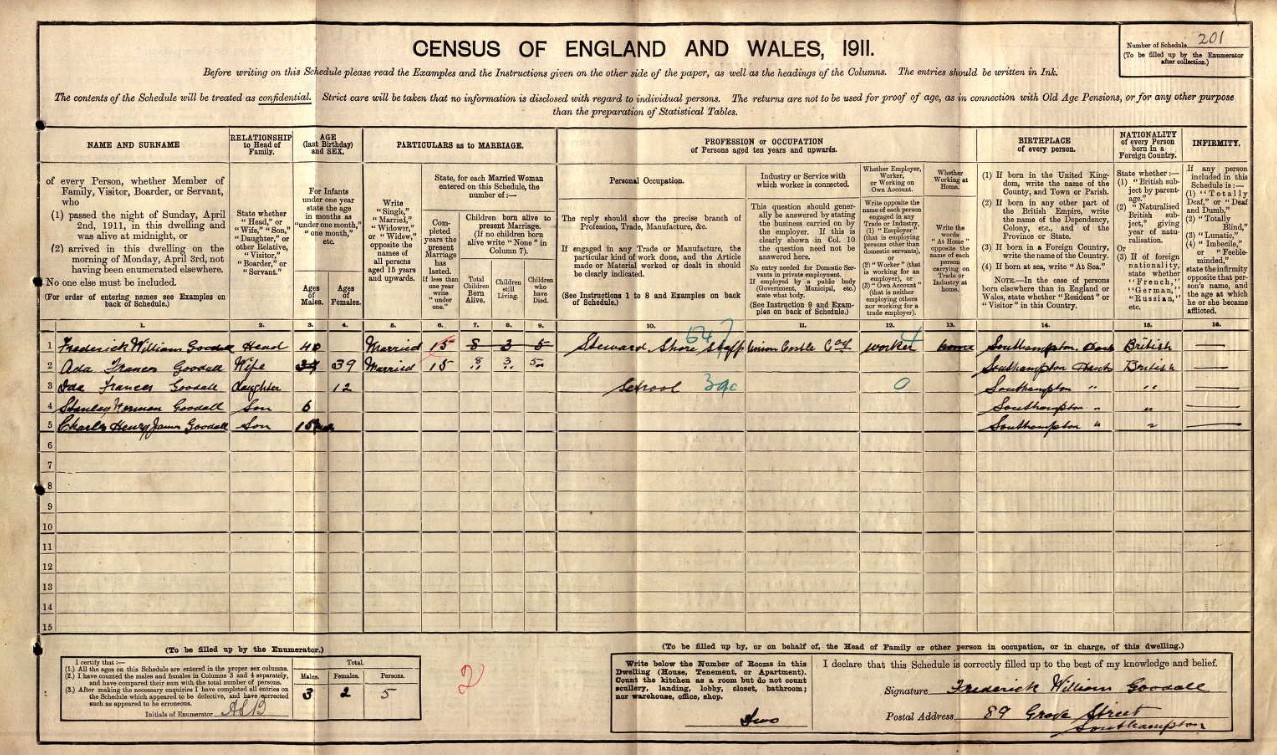
Going back to the 1911 Census, there are two families listed as living at no 89 Grove Street. Edward Collins and his family in four rooms and Frederick Goodall and his family, in two rooms.
Edward Collins from above; (Image of Census page above {1911 one page per family})
| Line No. | Name and Surname | Relation to Head | Condition | Age last birthday | Estimated Birth Year | Gender | Years married | Children born | Children still alive | Children who have died | Occupation | Employer / worker | Working at home | Where Born |
| 1 | Edward Collins | Head | Widow | 54 | 1857 | Male | House Carpenter | Worker | St Mary's, Hampshire, England | |||||
| 2 | Alice Collins |
Wife
|
Single | 37 | 1874 | Female | 16 | 3 | 3 | 0 | St Mary's, Hampshire, England | |||
| 3 | Elsie Collins |
Daughter
|
Single | 15 | 1896 | Female | St James | |||||||
| 4 | Letitia Collins |
Daughter
|
Single | 13 | 1898 | Female | St James | |||||||
| 5 | Kathrine Collins | Daughter | Single | 8 | 1903 | Female | St Mary's | |||||||
| 6 | Jessie Collins |
Daughter
|
Single | 22 | 1889 | Female | St James | |||||||
| 1 | Frederick William Goodall | Head | Married | 40 | 1871 | Male | Steward Shore Staff - Union Castle Co. | Worker |
Southampton, Hampshire |
|||||
| 2 | Ada Franes Goodall | Wife | Married | 39 | 1872 | Female | 15 | 8 | 3 | 5 | Southampton, Hampshire | |||
| 3 | Ida Frances Goodall | Daughter | 12 | 1899 | Female | School | Southampton, Hampshire | |||||||
| 4 | Stanley Herman Goodall | Son | 6 | 1905 | Male | Southampton, Hampshire | ||||||||
| 5 | Charles Henry James Goodall | Son | 10/12 | 1910 | Male | Southampton, Hampshire |
In the 1911 Census, from the records regarding 89 Grove Street, going back alone the Enumerators walk, assuming that is the order;
- 88 Grove Street, Charles Gates, Mellie Gates, and Mary Ann Privett - Mother-in-law, in 4 rooms
- 6 New Court, Grove Street, John Walker, and Mary Ann Walker, in 2 rooms
- 5 New Court, Grove Street, Georgiana Virgo, and Charles Loving - Boarder, in 2 rooms
- 4 New Court, Grove Street,
- 3 New Court, Grove Street, Joseph James Riggs, and Anna Elizabeth Riggs, in 2 rooms
- 2 New Court, Grove Street, Thomas Knowles, and Caroline Knowles, in 2 rooms
- 1 New Court, Grove Street, James Mason, and Annie Mason, in 2 rooms
- 87 Grove Street, Alfred Charles Gapper, May Gapper, Alfred Robert Gapper, and Edward Robert Gapper, in 4 rooms.
That makes sense with the book stating that New Court is only accessible through a narrow passageway between nos. 87 and 88 Grove Street, and that matches the 1870 Map above.
It is even easier to see in the 1901 Census, where the Enumerators route is continuous, not one detail page per family plus a header page, as found in the 1911 Census. New Court is between no 87 Grove Street (on the previous page) and 88 Grove Street. 89 is next, shown in the 1901 Census image above.
My conclusion is that 89 Grove Street is near the Chapel Road end, in the vicinity of New Court.
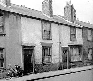
There is even a photo of 89 Grove Street included in the book.
Fortunately, Southampton Council undertook an extensive photo survey of properties before demolition.
Summary
Subject: Photograph. These houses, situated on the east side of the street, date back to the 1830s or 1840s. They were demolished c1960.
Record details
Main title:
88-94 Grove Street
Imprint:
Southampton City Council
1959
Collation:
Bitonal (1bit)
Credits:
SCC Archives Services
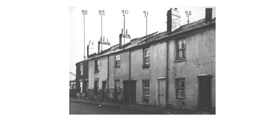
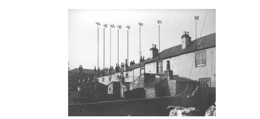
Click on the image to go to the source, where full page images are available.