Tithe Apportionment - Collection
This page is dedicated to Mr Gerry Dutton of Basingstoke whose work on the The North Hampshire Tithe Map Project and the resultant website gave me the inspiration to consider my work on Tithe Apportionment and Maps as a collective as well as the previous thought of only including the work within the relevant One Place Studies or articles. Thank you for the inspiration.
In order of my creation of the Articles
Tithe Apportionment - Sopley
Tithe Apportionment - Millbrook
Tithe Apportionment - Whiteparish
Tithe Apportionment - Nursling
The object of this article is to pull together the other articles that deal with Tithe Apportionment and Maps.
{slider title="Tithe Apportionment - Sopley" open="false" class="icon"}
Your text...

Tithe Apportionment - Parish of Sopley, Hampshire
Introduction
Tithe Apportionment
Time for a bit of time travel. Away from the Vikings, William the Conqueror, and the Domesday Book. Not all the way to the current day but to another significant change in the rural community.
Whereas an Agreement for the COMPUTATION of TITHES in the Parish of Sopley in the County of Southampton was, on the Eighteenth day of June in the Year One Thousand Eight Hundred and Thirty Nine confirmed by the Tithe Commissioners for England and Wales, of which Agreement, with the schedule thereunto annexed, ...

A jump to 18/06/1839 form 1086 in a single leap, missing out the Inclosure Acts of 1773 et al. Sometimes known as the Enclosure Acts.
I have recently purchased a copy of the Sopley Tithe Map and Award from the Hampshire Record Office. This is the record of the Tithe Survey for the Sopley area.
Tithes were originally a tax which required one tenth of all agricultural produce to be paid annually to support the local church and clergy. After the Reformation much land passed from the Church to lay owners who inherited entitlement to receive tithes, along with the land.
By the early 19th century tithe payment in kind seemed a very out-of-date practice, while payment of tithes per se became unpopular, against a background of industrialisation, religious dissent and agricultural depression. The 1836 Tithe Commutation Act required tithes in kind to be converted to more convenient monetary payments called tithe rentcharge. The Tithe Survey was established to find out which areas were subject to tithes, who owned them, how much was payable and to whom.
From the map and award I hope to be able to locate the place of residence of some of my ancestors.
The award, which may have also been known as a living, was granted to Reverend John Parish Hammond, Clerk Vicar of the Parish, and his successors, in the sum of £330 and 10 shillings per annum in respect of the vicaraul and small tithes. The Rector, William Wyndham, of Denton, Wiltshire, and his heirs and assigns, is granted £552, in respect of the Rectoral or Great Tithes of Corn and Grain. What sort of living would that provide? Depending on how it was calculated the vicar would be on, somewhere in the range between £28,360 and £380,000. Not too shabby. The rector would fair somewhat better, not surprisingly. His income range was £47,370 to £634,700, each year. Time to read some Jane Austen again? Quite a comfortable living.
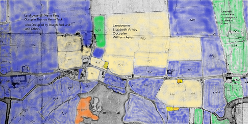
The very first entry in the schedule prompted another diversion including some therapeutic colouring in, albeit digital. The Tithe Map on the CD from Hampshire Record Office is not for reproduction. However, I have a subscription to The Genealogist and they have recently published the Tithe Survey data from the National Archives. It has predominantly the same information as the CD. However, it does provide a download button. The first entry of the Sopley schedule is a Landowner called Elizabeth Arney. She has one primary tenant and several lesser tenants. Using the tithe maps, the historic maps and internet maps, the majority of her holdings were found to be in and around Avon, in Hampshire. I downloaded the Tithe Map of Avon, part of the Parish of Sopley, and then colour washed the plots for the three major landowners in the area. There are a few plots not coloured in, generally in individual ownership.
Not quite the current fad of adult colouring in books, but similar.
I find it interesting that the large majority of the land is owned by just three people. I suspect that this is not that unusual for the period. In the Domesday Book period the Landowners would have predominantly have been the aristocracy. The blue is however a Sir, not quite blue blood, or perhaps he is. The orange represents the small amount of Common Land left after all the changes to rural life.
Elisabeth Arney owned 39 acre 1 rood 16 perch, or 39.35 acres, or 15.92 Hectares, and had to pay the vicar £4 14s 10d in Rent-Charge, each year. Together with a further £9 19s 7d to the impropriator (a person to whom a benefice is granted as their property). Is this the Rectors Share, in which case it was paid to William Wyndham.
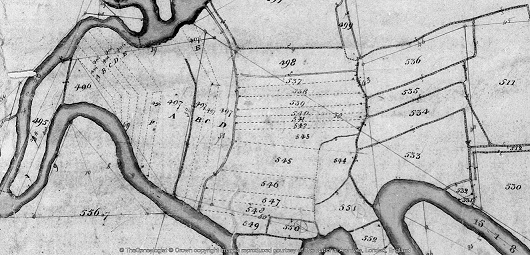
The next landowner on the schedule is George Aldridge. His middle name is either Clive or Olive. The Genealogist transcription opted for Olive. I'm more inclined towards the more conventional Clive. The easy bit is that he owns and lives at Sopley Mill. Easy to find on both old and current maps as the building is still there. The interesting thing for me is the another of his plots. Plot 497D, which is annotated as Sopley Sharphams, or something similar.
Looking at the plot on the tithe map it seems to be an area of strip farming south of his mill, on the other side of the river, not far from Sopley Common. This led me to looking for different names for strip farming and consequently a site on field systems. Open fields is one name, but that does not fit with Sharphams.
An extract of the article;-
The move towards enclosure gathered pace during the late 18th and early 19th centuries. At this time Parliamentary enclosure field systems were laid out through a series of Parliamentary Acts resulting in wholesale enclosure of land previously held within the open-field system. In total, 21% of England was enclosed by the Acts; 7 million acres of land was affected, two-thirds of which had been arable, the remainder waste. The Parliamentary fields in many ways resembled earlier regular enclosed field systems in that they were typically rectilinear/square in outline and set together, where topography allowed, with mathematical regularity.
Commons and open-field or strips were lost in this process. The strips have been replaced with fields, albeit still relatively small.
Parish of Sopley Tithe Apportionment Data Set
Although the paragraphs of this article are not dated it has been a few weeks since the last entry. I have been very busy extracting the data from the Tithe Apportionment and transcribing it into a spreadsheet. The images have detail pages and summary pages. Using both to create a form of double entry enabled me to validate my own input, and incidentally, that of the original scribes. The numbers for acres and the two rents were correct on the original and the double entry spreadsheet. There were a very few anomalies in spelling of names between detail and summary, and I opted for the detail version. One error was a tenant of Elizabeth Arney who was described as Henry Corbin in the Summary but George Corbin in the Detail. I have opted for George Corbin. I hope this will be confirmed by the 1841 Census.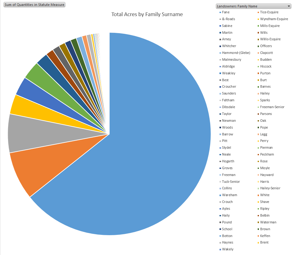
Using the spreadsheet I can now analysis land usage and ownership. See potential family ties. The total number of shops for the whole parish is amazingly low. The only industrial premises in the parish appears to be the Sopley Mill, whereas Farms abound. There are 46 plots which appear to be residences, the majority described as cottage, with some houses, farm houses, and one mansion house.
The latter being Sopley Park, which at the time was owned and occupied by George Brander Willis Esquire. George was a 1st Lieutenant in the Royal Artillery, from 17 November 1809 an fought in the Peninsular War. He was also a painter with his View of Bayonne (1814) being held in the Royal Collection Trust. Click here to see the image held at the Royal Museums Greenwich. George was the son of Revd James Willis, fought with Wellington and died on 29th August 1868, at the age of 79. He was about 20 when he became a 1st Lieutenant, and served his country in Holland, Spain and America.
However, the biggest landowner was Sir Henry Fane. He lived at plot 892, Avon Hills Cottage. the link to plot 892 is to The Genealogist website, which also holds images and index transcriptions of the Title Maps. I am a subscriber, so the link works for me, apologies if it does not work for you. I also used The Genealogist data to cross check mine if I was having trouble reading the script, or finding plots. Back to Avon Hills Cottage. I think cottage gives the wrong impression. Firstly the plot is 7 Acres 3 roods 30 perch, or 7.9375 Acres or 3.212 Hectares. That is very large for a cottage. Looking at other old maps and current Google Maps, plot 892 has Avon Tyrrel and Tyrrells Ford Country Inn & Hotel respectively. An extract from the hotel's website, 18th century Manor House hotel set in 8 acres of beautifully peaceful grounds on the edge of the New Forest. Tyrrells Ford Country Inn & hotel is situated in the Avon valley in Hampshire. Avon Tyrrel is has a rich history according to Wikipedia. Sir Henry Fane 26 November 1778 – 24 March 1840, also fought with Wellington, and had a distinguished army career, and served both as a member of Parliament and Commander-in-Chief of India. Sir Henry had holdings of about 2200 Acres across the Parish of Sopley, amounting to 64% of the Tithe area. Made up of Arable 1383.625, Meadow 302.5, Pasture 212.31, Wood 176.85, and others, across 80 tenants. The graph of Total Acres by Family Surname for the Parish of Sopley clearly illustrates the dominance of Sir Harry Fane in the Parish, and reinforces the map above with plots coloured in by landowner.
The Tice surname is next on the list, with a mear 8%. Even the Willis Family with the mansion house is just 1%, which is still a big landowner and very wealthy, just in a different league to Fane. This is only 1839, less than 200 years ago.
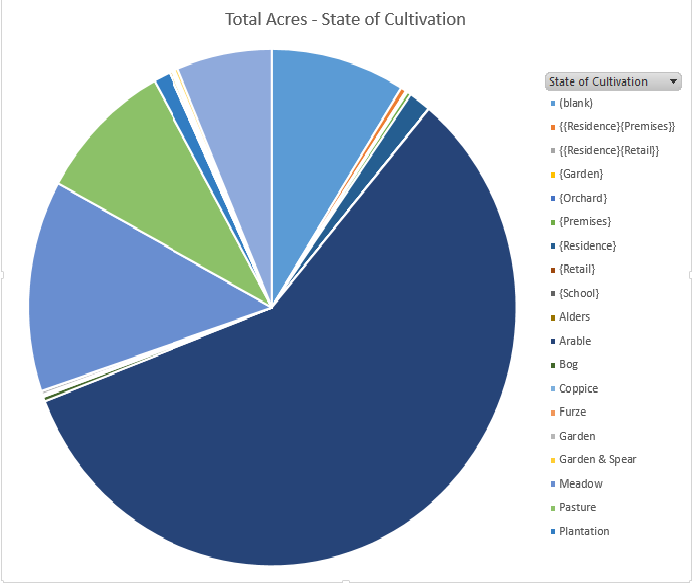
Again looking at the information extracted from the Tithe Apportionment using the spreadsheet. The graph represents the State of Cultivation recorded on the survey together with some reasonable assumptions based from the Lands and Premises data, shown in { }, with the largest being Arable 58%, followed by Meadow 13%, Pasture 9%, Wood 6%. Most definitely a farming community. The remaining significant slice of pie is (blank) at 9%, ie no recorded or implied use.
more later
{slider title="Tithe Apportionment - Millbrook" class="icon"}
Your text...

Tithe Apportionment - Parish of Millbrook, Hampshire
Note the reference to Depopulation and read more about it here. By 1530 the population of England and Wales had risen to around 3 million. At the end of the 17th century it was estimated the population of England and Wales was about 5 1/2 million. The population of Scotland was about 1 million. The population of London was about 600,000. London went on to become the biggest city in the world for a while. In the 19th century Britain became the world's first industrial society. It also became the first urban society. By 1851 more than half the population lived in towns. As our population approaches 70m it is interesting to think of depopulation efforts at 3 million! The maps of Millbrook clearly show the urbanisation of the countryside.
Following the Tithe Commutation Act 1836 Tithe Maps were produced which recorded both the Landowner and Occupier for most lands. From the Tithe Apportionments records it is apparent that on 4th March 1843 Lady Hewitt
was both the Landowner and Occupier of Plot 875, Freemantle Estate, described as House Offices and Pleasure Grounds, with an area in statute measure 6,0,2, about 2.4 Hectares.
Nathaniel Newman Jefferys was both Landowner and Occupier of Plot 825 described as House Offices and Garden, an area of 2,2,24 imperial, on 4th March 1843. However, one plot does not show the full picture.
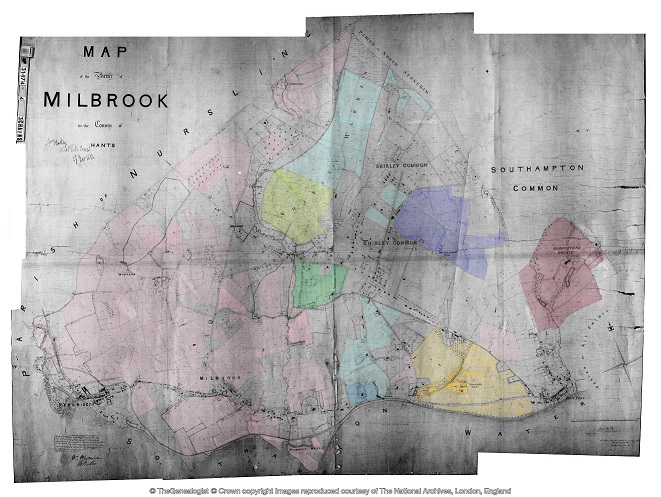
Using the Tithe Apportionment map of the Parish of Millbrook, Hampshire, as a base, I have colour washed some of the plot landowners. The Freemantle and Banister Estates, pale orange and brown respectively can be clearly seen. The landowners in 1843 where Lady Hewitt and Reverend William Fitzhugh. Shirley Park, owned by William Henry Roe, is in green. Blightmont Lodge, occupied by Lady Lisle, just north of Millbrook Road, and part of the larger Berrywood estate owned by Nathaniel Newman Jefferys is shown in a slightly darker blue than the light blue of the rest of the estate. It appears that Nathaniel Newman Jefferys has bought a large swath of the newly released Shirley Common land in the area of Shirley Warren. Clement Hoare & William Dunn seem to have also taken advantage of the inclosue of Shirley and Nutshalling Commons, as joint owners of plots coloured lime green. Roads such as Warren Avenue, Warren Crescent and Tremona Road have already been laid out for the impending urbanisation. However, the biggest landholding in the Parish, by a long way, is Sir John Barker Mill and various associates who together are landowners of the pink coloured plots, mainly farmland in 1843, but destined to be developed and absorbed as suburbs of Southampton.
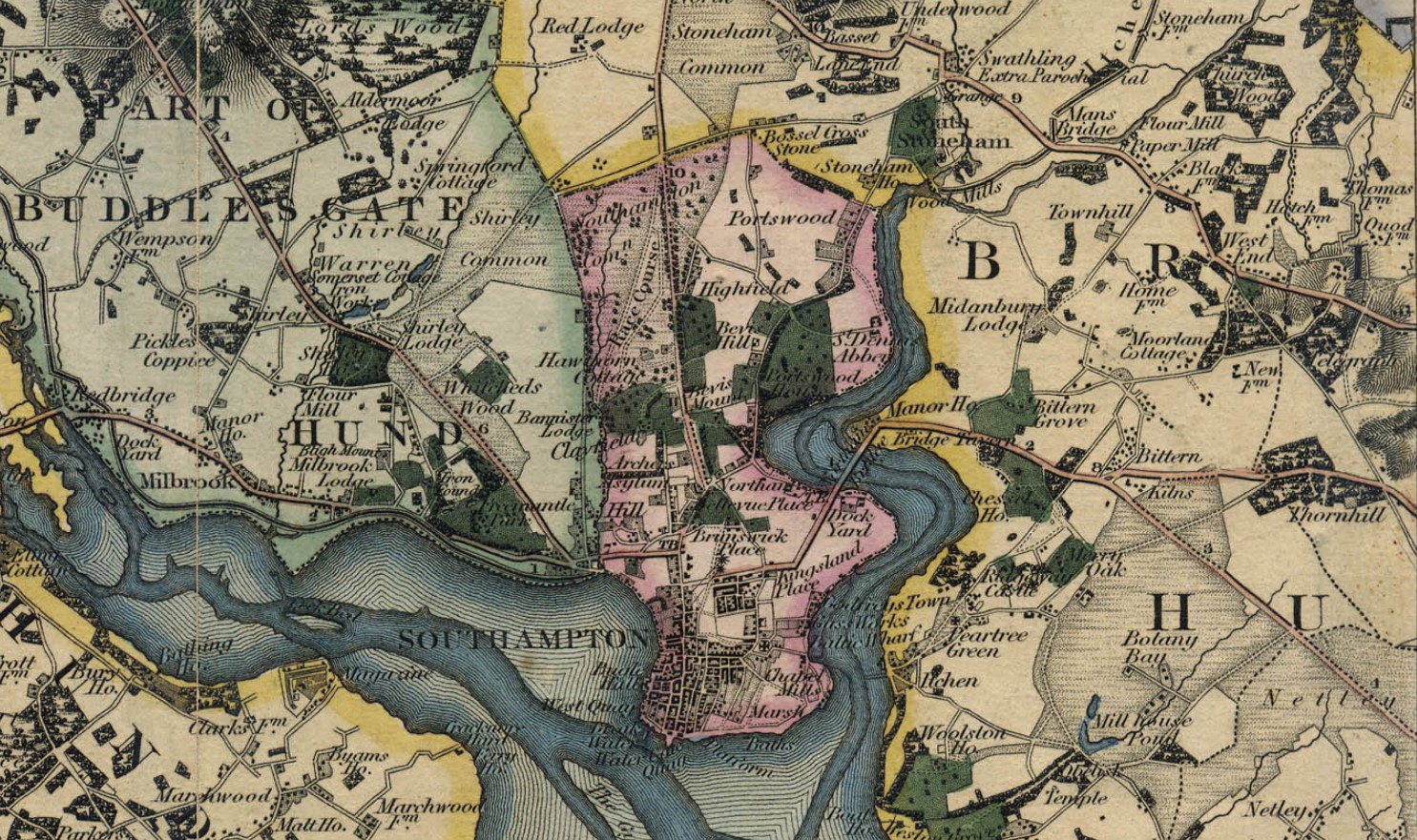
Greenwood's Hampshire 1826 section 53
Moving into the current, the Church of England has a database of interesting statistics about all the Parishes in the country. Below is the Map which covers the original Millbrook Parish and shows the current Parishes of;
Millbrook: Holy Trinity
Freemantle: Christ Church (1851)
Shirley: St James (1836)
Maybush.
Click on the parish to bring up the statistics.
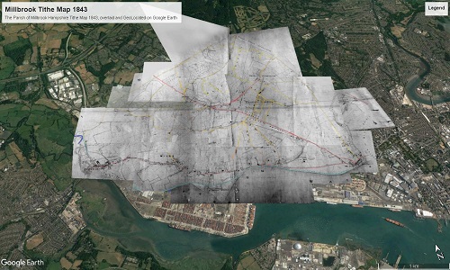
The Parish of Millbrook Tithe Map 1843 including Shirley, Freemantle and Four Posts, layered onto Google Earth Pro and Geolocated. Same base map as the coloured ownership map. Over 20 separate tiles or files to fit spherical base globe of Google Earth. All adjusted to best fit the projection, and align roads and as many details as possible. Below is just an image of the result. Google Earth Pro is desktop based so does not lend itself to sharing. However, using transparency of the layers I can locate buildings on the tithe map and see what is there now. I can also use the Lat and Lon and show on Google Maps to georeferenced individual buildings or plots.
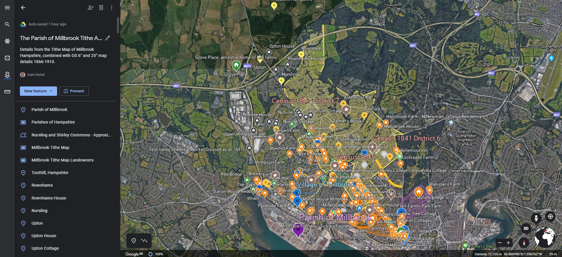
The interactive version is created using a Project in Google Earth and can be seen here, The Parish of Millbrook Tithe Apportionment. Using the Tithe Map plotted on Google Earth Pro above and other maps, I have placed some of the Property names onto a Google Earth Project with an up to date backdrop. History mapped to now.
A screenshot as at March 2020. Work ongoing.
Freemantle
Freemantle Estate
more later
{slider title="Tithe Apportionment - Whiteparish" class="icon"}
Your text...
Tithe Apportionment - Parish of Whiteparish, Wiltshire
There is a possibility that some of my ancestors lived there and migrated from there.
That requires further investigations.
This is part of those investigations. There are three main streams, one is via ESRI ArcGIS StoryMap and another other a spreadsheet based database. The third is the normal family tree, both in Ancestry and TNG. The TNG list of the people of Whiteparish currently starts with Elizabeth born in 1565.
A child with the surname Hurst was born in 1564, and Edith Hurst was born in 1566, both in Whiteparish. The question of are these people related remains un-answered at the moment.
Introduction
Your text...
Transcription
Your text...
Core Data
Your text...
Detailed Data
Your text...
Mapping
Your text...
Statistics
Your text...
Conclusion
Your text...
The StoryMap is below, and the spreadsheet full of interesting records below that. The Story Map Tithe Apportionment Parish of Whiteparish can also be open in a new window by clicking on the link.
Depending on your computer and your internet connection you may have to be a little patient and allow the StoryMap time to load the maps and images.
The Dataset
Graph of Land Usage in Whiteparish in 1842 from the Tithe Apportionment information.
Graph of Land Ownership in Whiteparish in 1842 from the Tithe Apportionment information.
The Table with all the data of the Detailed Plot register.
This table has the Landowners and Occupiers of all the Plots in the Parish, including the Description or Names of the plots together with the State of Cultivation. It instances where there is no entry, but it is evident what the Land Usage is I have added the category surrounded with { Brace Brackets }. Not relative to the Tithe Apportionment as some of the Land Usage is not part of the charge regime, however {Residence), {Premises} and {Retail} etc are useful additions. There are approximately 220 Mansions, Houses, or Cottages etc, across the Parish.
The areas of each plot together with the Rentcharge amount in respect of both the Small and Great Tithe, for the Vicar and Impropriator.
Top Ten Landowners in Whiteparish from the Tithe Apportionment information
From this analysis of the plot level detail for the Parish of Whiteparish the Top Ten Landowners own 91% of the whole recorded area of the parish. Two of the Landowners were relations to the Nelson of The Battle of Trafalgar fame.
Horatio Nelson, 3rd Earl Nelson, (7 August 1823 – 25 February 1913), was 16 years 9 months 7 days at the recorded data of the survey, 14th May 1840, a Minor, hence the Guardians of ...
He was the son of Thomas Bolton (a nephew of Vice Admiral The 1st Viscount Nelson) by his wife Frances Elizabeth Eyre. On 28 February 1835 his father inherited the title Earl Nelson from William Nelson, 1st Earl Nelson and adopted the surname of Nelson. He died on 1 November that year, and his son Horatio succeeded to the title and the estate, Trafalgar House in Wiltshire, in the nearby parish of Downton. The Eyre Family were the owners of Brickworth Park according to the Turnpike Acts for the Whiteparish Romsey Southampton Road. The Dowager Countess Frances Elizabeth Nelson was recorded as being the Landowner as Brickworth Park.
The remainder are either titled or referred to as Esquire. Although not all of the Esquires are in the top ten.
more later
{slider title="Tithe Apportionment - Nursling" class="icon"}
Your text...

Tithe Apportionment - Parish of Nursling, Hampshire
Part of a Study of the Parish of Nursling in the County of Hampshire, or sometime known as the County of Southamptonshire.
The details are behind the dropdowns.
{slider title="Introduction" class="icon"}
Introduction
For details about what Tithes where, how they came about, and the Tithe Commutation Act that gave us all this wonderful information read the article titled Tithe Commutation Act 1836.
The Award of Rent-charge in lieu of Tithes in the Parish of Nursling in the County of Southampton. Hampshire variously known as the County of Southampton, Southamptonshire, and abbreviated to Hants.
This is the fourth iteration of Tithe Apportionment articles, and the first of the new templated concept.
Details of the Parish of Nursling are included in the One Place Study about Nursling
{slider title="Notes" class="icon"}
Notes and Stories
William Wakeford Attree
From the 'Know all Men' paragraph, the Assistant Tithe Commissioner responsible for Nursling was William Wakeford Attree of the Middle Temple Barrister at Law. He was also responsible for the Tithe Commutation for the Parish of Freefolk in the County of Southampton, and possibly others.
I found an article in The National Archives which has some information about William Wakeford Attree and his family, extract below. The Atrree family do not live in Nursling but have an involvement by virtue of the Tithe Award.
THE HISTORY OF HOWLETT & CLARKE by Antony Dale
Howlett & Clarke is not only the oldest firm of Solicitors in Brighton but the only one that can be traced back to the eighteenth century. Its first known principal or partner was William Attree. He came of an old established Ditchling family. His grand-father, William Attree, was a brick-layer there. The latter died in 1767 but left a Will, so he must have been a man of some education. This William Attree's son, John Attree, was a prosperous malster. In 1745 John Attree married at Newtimber Susannah, daughter of Henry Scrase of Withdean, Patcham. He died on the 9th June 1772 and is buried in a table-tomb in Ditchling church-yard to the north of the church
John and Susannah Attree had one daughter and four sons
William Attree was the second of these sons and was born in 1749. In 1765 he was articled for 5 years to an attorney in Lewes named Henry Burtenshaw. He was admitted to the roll of solicitors before 1775. But this must have been at least two years earlier, as in 1773, when the Brighton Town Commissioners were first set up to pave and light the streets and to erect groynes in front of the town, he became their first Clerk and also Treasurer. The Commissioners' minutes have not survived from before 1789, but Bishops' "Brighton in the Olden Time" quotes an advertisement by William Attree as Clerk to the Commissioners of 1st August 1773, so he must have held this office since the initiation of the Commission. His salary as such in 1789 was £4-10-0 a year
He was also Clerk to the Brighton Vestry. The date when he was appointed to that office is unknown because again the minutes of the Vestry have not survived from before 1790. He may well have been in office for some time before that date and perhaps was even appointed Clerk to the Commissioners in 1773 because he was already Clerk to the Vestry. His salary as Clerk to the Vestry was £10-10-0 a year in 1790 and £30-0-0 a year in 1804
It is just possible that William Attree's legal connection may extend further back than this. His mother's first cousin, Charles Scrase, was also an attorney. He was born in 1709 and was Town Clerk of Seaford in 1733. In 1771 Scrase purchased a moiety of the manor of Brighton and lived in the Manor House there which was on the site of Royal York Buildings in Old Steine. Scrase was also the solicitor of Dr Johnson's friend, Hester Thrale, later Mrs Piozzi. She stayed with him at the Manor House and subsequently bought a house of her own in Brighton in West Street. William Attree acted as steward of the Manor for Scrase from 1778 onwards. So it is possible that he had been articled to Scrase. The latter died in 1791
When William Attree established his practice in Brighton, he built himself an office and a house where he also lived. In 1775 he bought a site in Ship Street for £50. On this he built No. 8 Ship Street and probably the adjoining house, No. 9. No. 8 was his residence and office combined until his death and after that the residence and office of his son until 1830. William Attree mortgaged the building for £2,000 in 1803, and this loan was not finally paid off by his son until 1824. The house was rebuilt in its present form, but still with a facade of Georgian character, at some time between 1830 and 1863. But continuity has been preserved as the building is still the office of Howlett & Clarke today
In or before 1800 there were few attorneys in Brighton, so William Attree easily acquired a near monopoly of the best legal work in the town. Amongst his fashionable clients was the Prince of Wales. When the Prince was acquiring land to enlarge the grounds of his Brighton house, he employed Attree in the various purchases which this involved. Attree's position will have been of benefit to both parties when, in 1803, the Prince sought the agreement of the Town Commisioners to divert the north end of Great East Street, as East Street was then called, which ran almost directly under his windows, and to give the town instead a piece of land further west which, in 1806, became New Road
The above is not really relevant to the Parish of Nursling but does give some background to the next extract where William Wakeford Attree, the Assistant Tithe Commissioner for Nursling and a number of other Hampshire Parishes.
Thomas Attree married about 1805. His wife's Christian names were Elizabeth Austin. They had a son and a daughter. The son, William Wakeford Attree, was born in 1806. He followed his father into the legal profession, but became a barrister in the Middle Temple. He was Recorder of Rye, Hastings and Seaford. He died in his father's life-time and at his father's Brighton house on the 28th January 1862 aged 56. He was buried in Ditchling church-yard
In his memory his father endowed a scholarship at Brighton College. To provide the money for this he conveyed to the Trustees of the College No 9 Ship Street adjoining his office and, if this Trust was invalidated by his death within 6 months of the date of gift, he substituted in his Will a bequest to the College of £1,000. Thomas Attree's daughter, Elizabeth Wakeford Attree, died when quite young. Stained glass windows in memory of both the son and daughter were inserted in the north wall of the nave of Ditchling Church in 1863.
{slider title="Transcription" class="icon"}
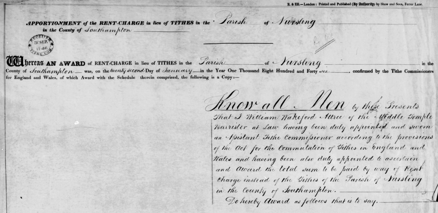
Transcription of Agreement
APPORTIONMENT; of the RENT-CHARGE in lieu of TITHES in the Parish of Nursling in the County of Southampton
Whereas AN AWARD of RENT-CHARGE in lieu of TITHES in the Parish of Nursling in the County of Southampton was, on the twenty second Day of January in the Year One Thousand Eight Hundred and Forty six confirmed by the Tithe Commissioners for England and Wales, of which Award with the Schedule therein comprised, the following is a Copy :---
Know All Men by these Presents That I William Wakeford Attree of the Middle Temple Barrister at Law having been duly appointed and sworn an Assistant Tithe Commissioner according to the provisions of the Act for the Commutation of Tithes in England and Wales and having been also duly appointed to ascertain and Award the total sum to be paid by way of Rent Charge instead of the Tithes of the Parish of Nursling in the County of Southampton.
Do hereby Award as follows that is to say.
Whereas I have held divers Meetings in the said Parish touching the matter aforesaid of which Meetings due Notice was given for the information of the Land owners and Tithe owner of the said Parish.
And Whereas I have duly considered all the allegations and proofs tendered to me by all parties interested and have myself made all inquiries touching the premised subject which appeared to me to be necessary.
And Whereas I find that the estimated Quantity in Statute measure of all the Lands of the said Parish which are subject to payment of Tithes amounts to one thousand nine hundred and ninety acres three roods and twenty one perches which are cultivated as follows that is to say.
One thousand and forty seven acres and sixteen perches as Arable Land
Four hundred and six acres three roods and thirty perches as Meadow or Pasture.
One hundred and thirty six acres three roods and five perches as Water Meadow
Three hundred and eighty three acres three roods and eighteen perches as Woodland.
And Four acres and thirty two perches are Homesteads and the Sites of Buildings.
And Whereas I find that the Glebe Lands belonging to the Rector of the said Parish amounting by estimation to Twelve acres statute measure is by prescription absolutely exempt from the render of all Tithes.
And Whereas I find that all the Lands of the said Parish are save as aforesaid subject to payment of all manner of Tithes in Kind.
And Whereas in estimating the clear annual value of the said Tithes I have taken into account the rates and assessments paid in respect of such Tithes during the seven years of average prescribed by the said Act.
And Whereas due Notice was was given to me in the manner prescribed by the said Act that the clear average value of the Rectoral Tithes of the said Parish during the said seven years of average would not fairly represent the sum which ought to be the basis of a permanent commutation of the said Tithes.
And Whereas I have taken into consideration all the allegations and proofs tendered to me touching the matter of the said Notice before awarding the Rent charge hereinafter mentioned.
And Whereas I find that the Rector of the said Parish for the time being is entitled to all the Tithes thereof.
Now Know Ye that I the said William Wakeford Attree do hereby Award that the Annual sum of Five hundred and fifty Pounds by way of Rent Charge subject to the provisions of the said Act shall from the first day of October next preceding the confirmation of the Apportionment of the said Rent Charge be paid to the Rector of the said Parish for the time being instead of all the Tithes arising from all the Lands of the said Parish except the Glebe Lands.
And I do hereby Award and direct that no part of the said Rent Charge shall be apportioned on any Holdings of less extent than thirty five perches.
In Testimony whereof I have hereunto set my hand this second day of January in the year One thousand eight hundred and forty six.
Signed
Wm Wakeford Attree
Now I Charles Fielder
of the Parish of Sparsholt near Winchester in the County of Southampton
having been duly appointed Valuer to apportion the total Sum awarded to be paid by way of Rent Charge in lieu of Tithes, amongst the several Lands of the said Parish of Nursling
Do HEREBY apportion the Rent Charge as follows:--
GROSS RENT CHARGE payable to the Titheowner in lieu of tithes for the Parish of Nursling in the County of Southampton
Five Hundred and Fifty Pounds
| Price per Bushel. | Bushels and Decimal Parts. | |||
| s. | d. | |||
| Wheat | 7 | 01/4 | 522, 25519 | |
| Barley | 3 | 111/2 | 926, 31579 | |
| Oats | 2 | 0 | 1333, 33333 | |
The above Transcription can be seen in plain text on the pdf file linked below, which opens in a new window.
![]() Transcription Tithe Agreement - Nursling.pdf94.57 KB07/03/2022
Transcription Tithe Agreement - Nursling.pdf94.57 KB07/03/2022
Transcription of the Schedule
The schedule is transcribed directly into the Dataset by double entry typing, and is therefore not repeated here.
Transcription of the Summary
The Summary is transcribed directly into the Dataset by double entry typing, and is therefore not repeated here.
Transcription of the Ratification
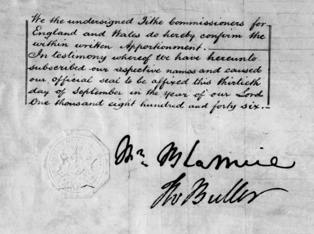
We the undersigned Tithe Commissioners for England and Wales do hereby confirm the within written Apportionment.
In testimony whereof we have hereunto subscribed our respective names and caused out official seal to be affixed this thirteenth day of September in the year of our Lord One thousand eight hundred and forty six.
The Tithe Commissioners whose signatures appear on the ratification are;-
William Blamire (chairman)
Thomas Wentworth Buller
At a later time than the original Tithe Commutation, the Apportionment was altered and attached.
Transcription of the Later Alteration
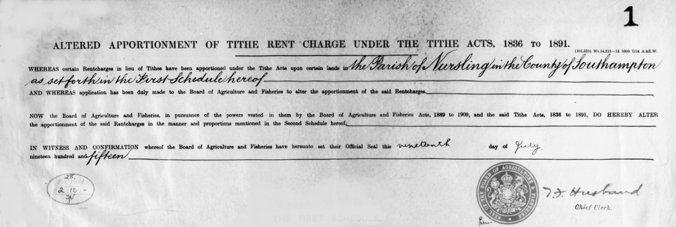
ALTERED APPORTIONMENT OF TITHE RENT CHARGE UNDER THE TITHE ACTS, 1836 TO 1891
WHEREAS certain Rentcharges in lieu of Tithes have been apportioned under the Tithe Acts upon certain lands in the Parish of Nursling in the County of Southampton as set forth in the First Schedule hereof
AND WHEREAS application has been duly made to the Board of Agriculture and Fisheries to alter the apportionment of the said Rentcharges.
NOW the Board of Agriculture and Fisheries, in pursuance of the powers vested in them by the Board of Agriculture and Fisheries Acts, 1889 to 1909, and the said Tithe Acts, 1836 to 1891, DO HEREBY ALTER the apportionment of the said Rentcharges in the manner and proportions mentioned in the Second Schedule hereof.
IN WITNESS AND CONFIRMATION whereof the Board of Agriculture and Fisheries have hereunto set their Official Seal this nineteenth day of July nineteen hundred and fifteen.
Transcription of the Amended First Schedule
The amended first schedule is transcribed directly into the Dataset by double entry typing, and is therefore not repeated here.
Transcription of the Amended Second Schedule
The amended second schedule is transcribed directly into the Dataset by double entry typing, and is therefore not repeated here.
{slider title="Primary Data" class="icon"}
Primary Data
Below is the first page of the spreadsheet containing the Nursling Tithe Dataset. It shows the Primary or key facts pertaining to the Parish of Nursling.
It is a live document, so if the dataset changes, so does this.
{slider title="Detailed Data - Summary" class="icon"}
Detailed Data - Summary
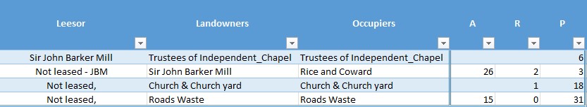
The Summary in the Tithe Apportionment paperwork often appears after the Schedule, and of which it is, as the title suggests, the summary, by landowner and occupier. It includes details of the area together with both the small and great Tithe.
The transcription is below as an extract of the spreadsheet containing the dataset.
Out of this first pass of information, with the addition of gender based on the names of the people, I have generated some graphs within the spreadsheet. They are live and interactive on the spreadsheet, but here they are screenshots.
As well as the addition of gender, there are some which are general neutral, such as Assignees, which includes Executors, Trustees and the like, Corporate, including the Church, and Public etc, which also includes roads, where measured.
Land Area - Acres
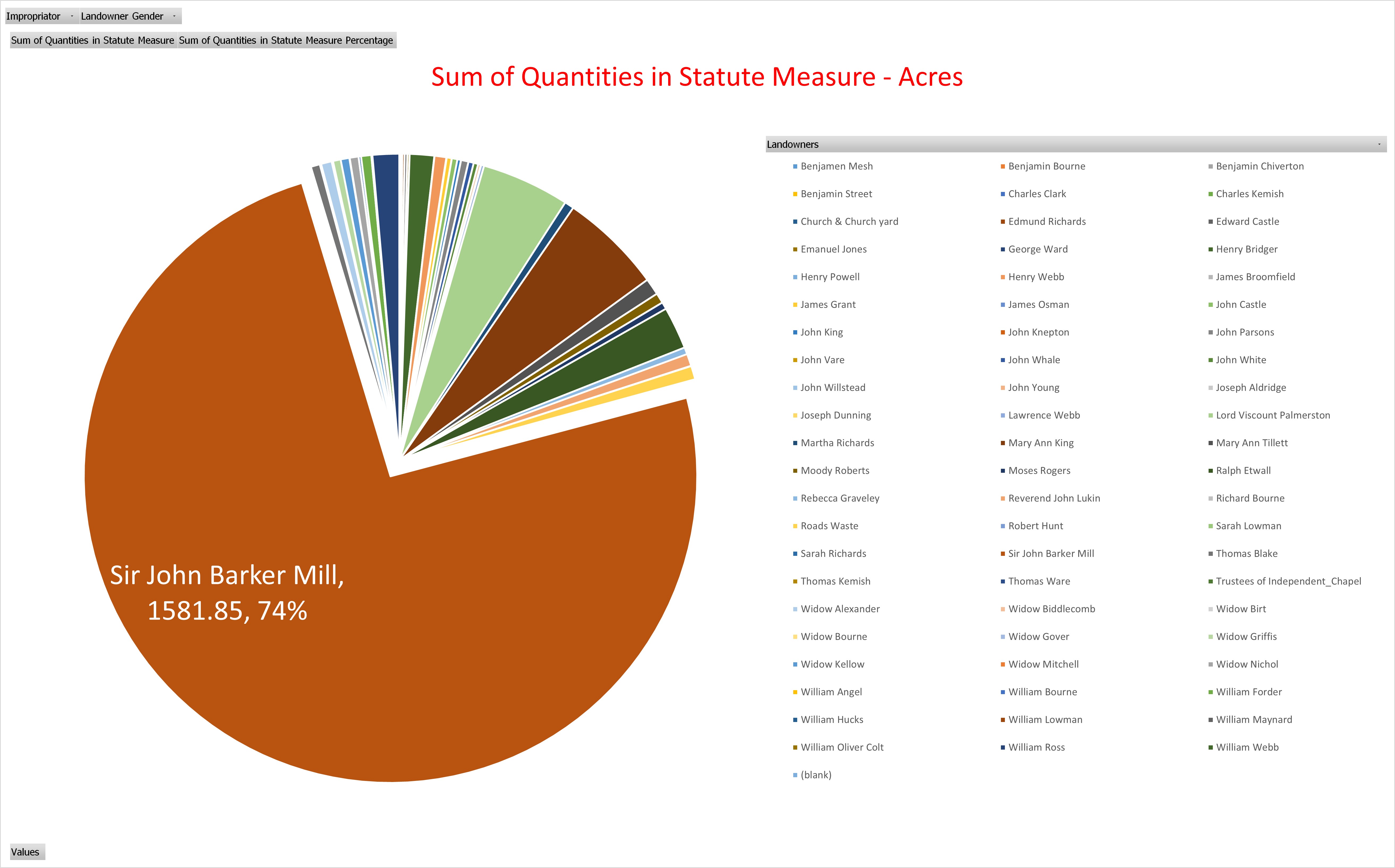
You can see from the Pie chart that Sir John Barker Mill is by far the largest single landowner with 74%. However, the graph does not show much other land he owns but leases to others, with the lessees recorded in the landowners column.
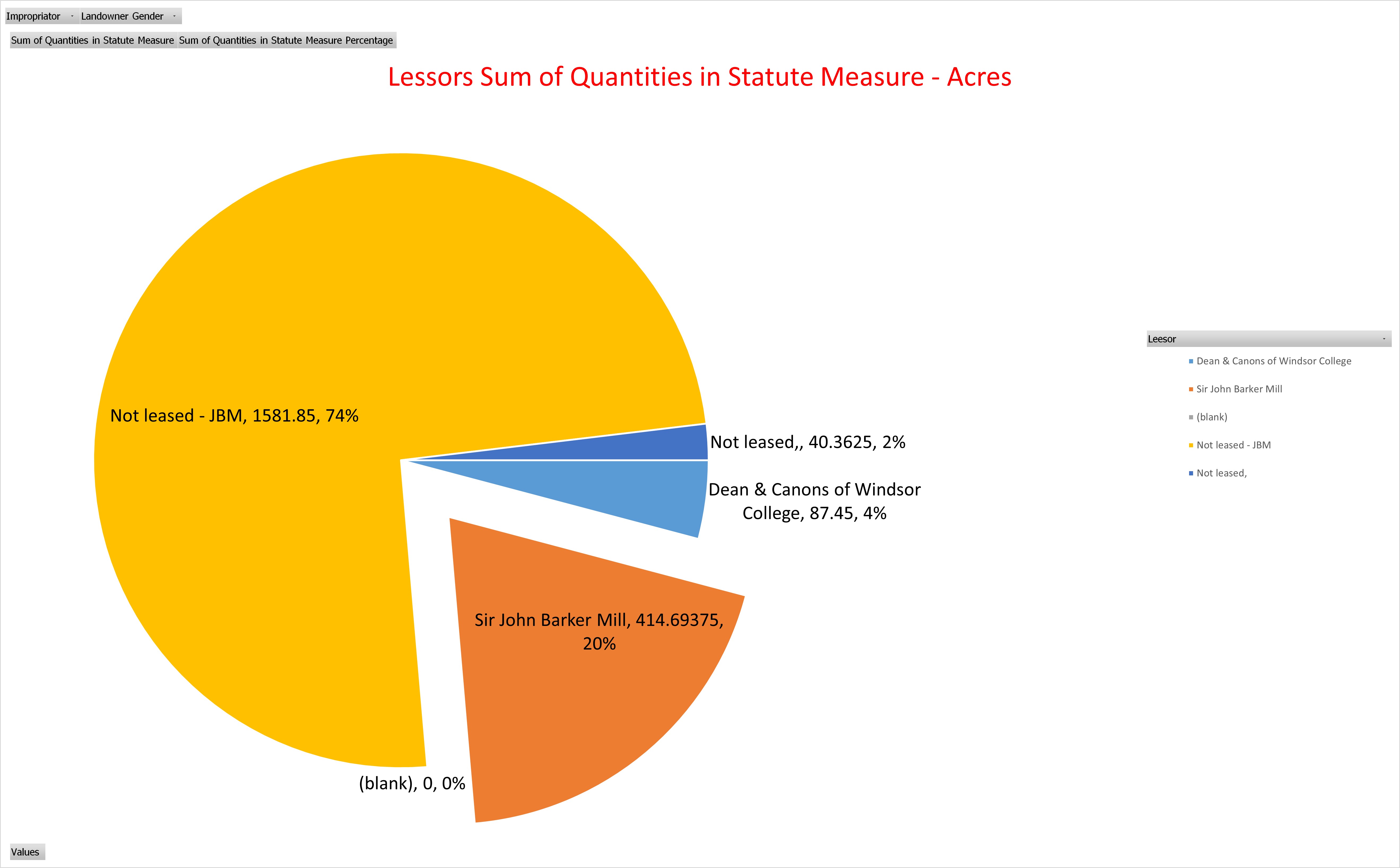
The Pie chart above shows the 1581.85 acres not leased out but owned by Sir John Barker Mill together with a further 141.69 acres, approximately 20%.. 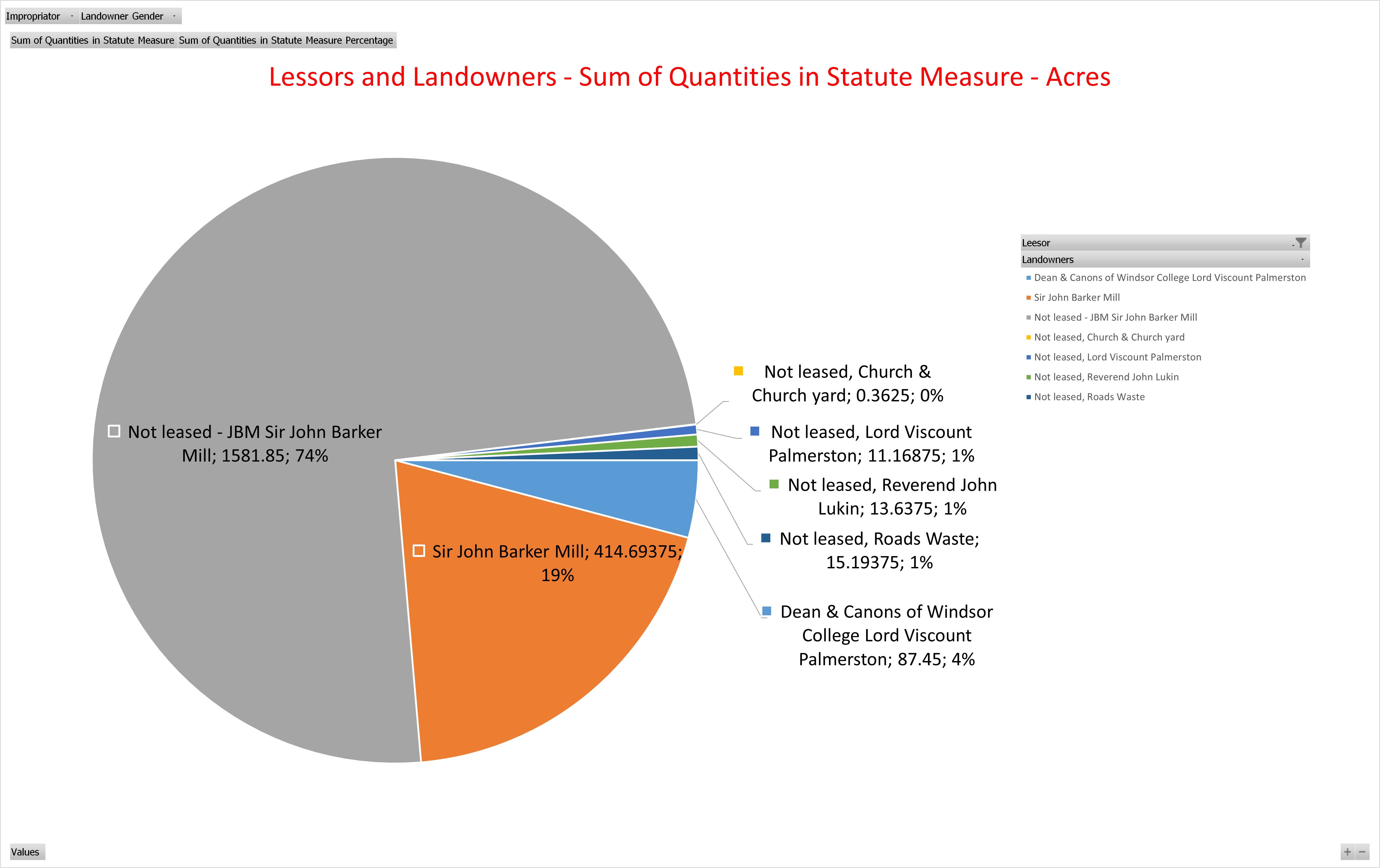
Altogether he therefore owns about 94% of the parish. The 19% of land where Sir John Barker Mill is lessor on the lower pie chart but 20% on the one above is just the way the numbers round.
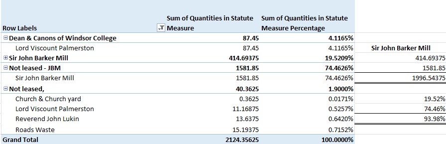
Lord Viscount Palmerston, the owner of The Broadlands Estate between Nursling and Romsey, is the only other Landowner, but even that, as both Landowner and Lessee, only equates to less than 5% of the total area.
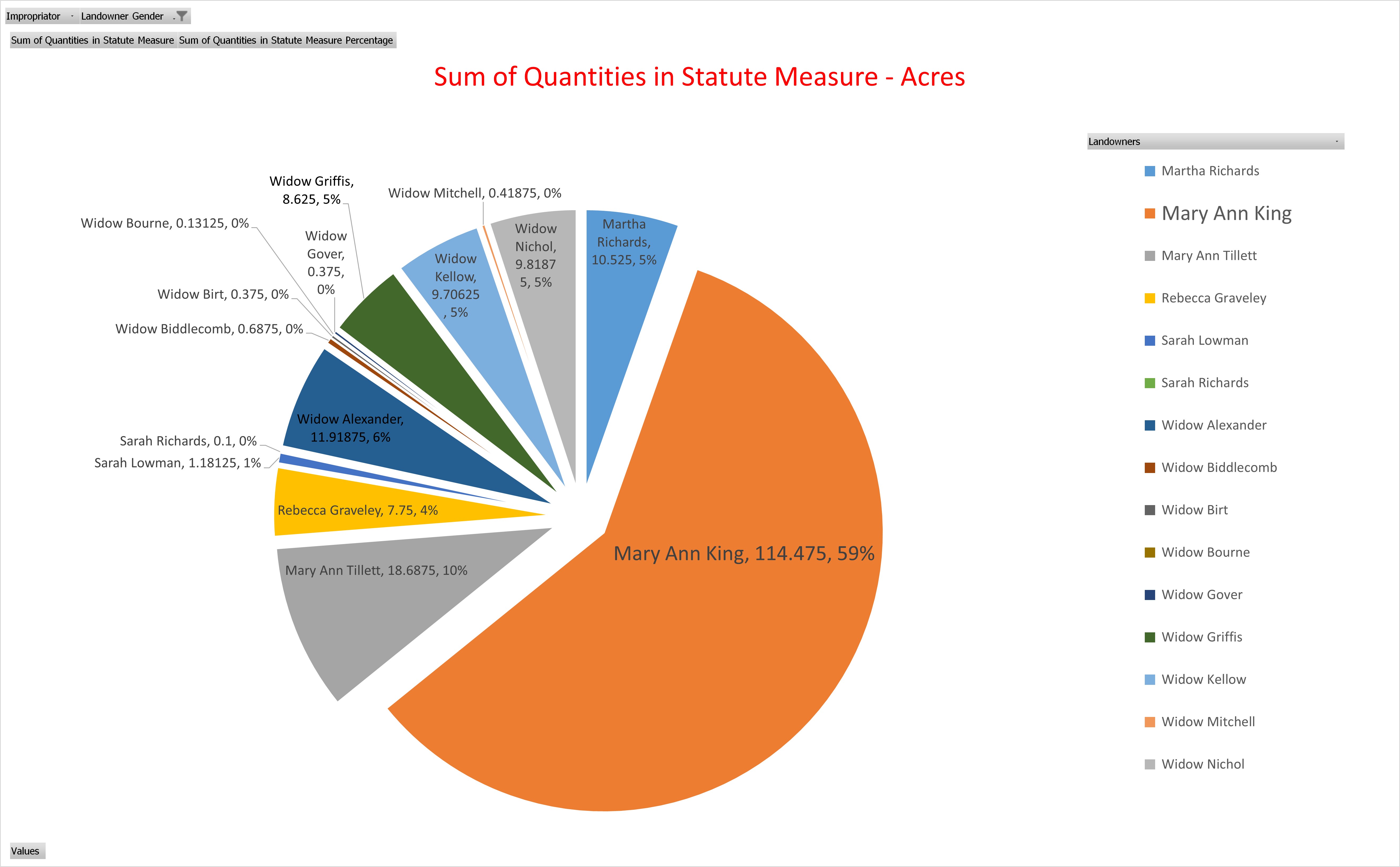
Looking at the gender split, 89% of the land is attributed to males as Landowners / Lessees with just 9% attributed to females. The pie chart above represents that 9%, with Mary Ann King clearly the leader with 114 acres, 59%. There are 9 Widows amongst the 15 women listed as Landowners / Lessees. Just known as widow of husband.
I recognise that in terms of gender 89% plus 9% does not equate to 100%. That is therefore 2% other.
Strictly speaking, this is not consistent with the other graphs as a large proportion of the other 2% is Landowner Sir John Barker Mill, so that would add another 1% of the whole to the male camp above. However, that land is occupied by Rice and Coward, who I have attributed to Corporate. It could be Mr Rice and Mr Coward, but that would normally be John Rice and another, if Mr Rice was a John. Having attributed Rice and Coward to corporate It thought it better to bring it out here for clarity.
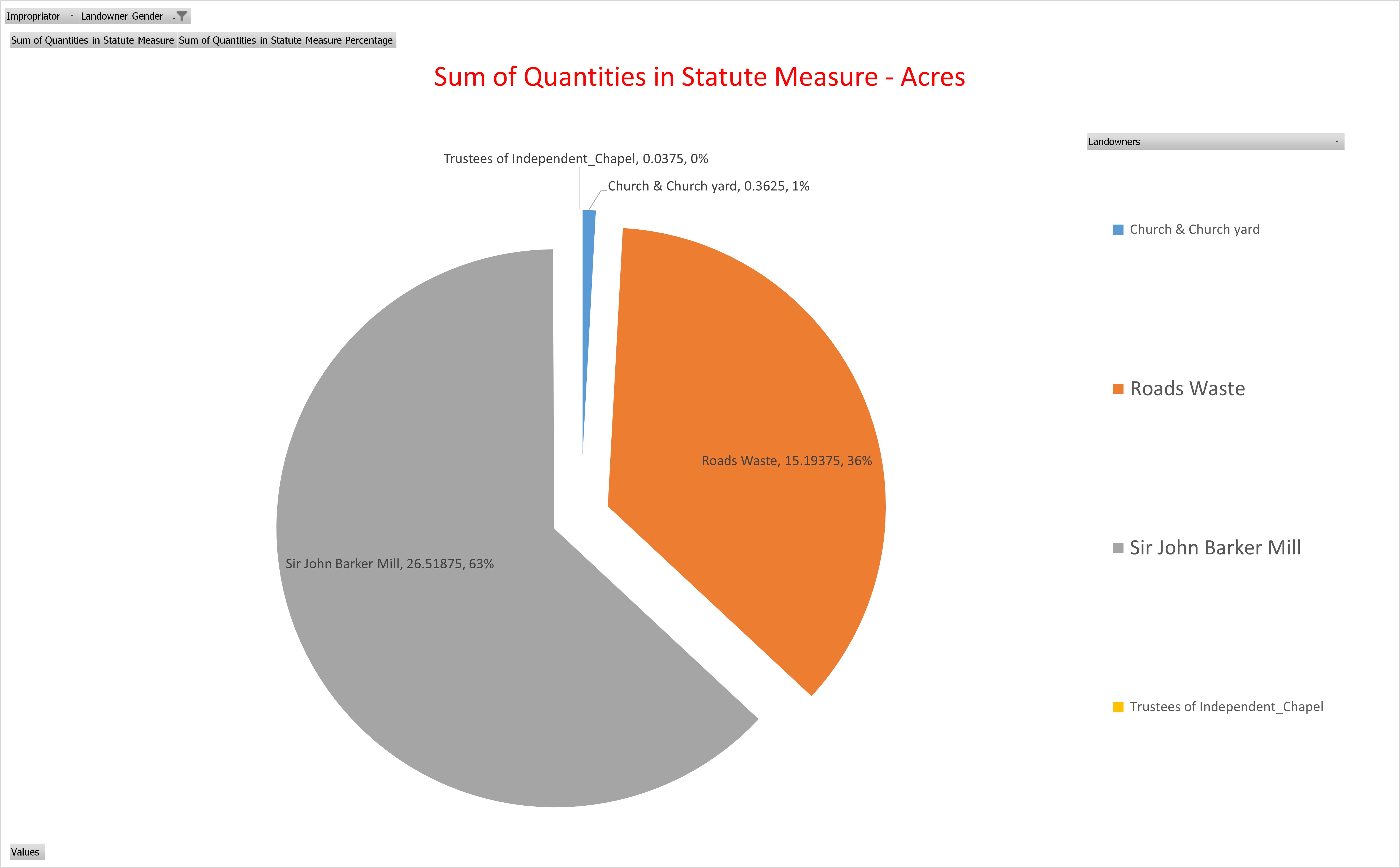
Rentcharge - Vicar
The is no value to the Vicar in the Tithe Apportionment for the Parish of Nursling
Rentcharge - Rector
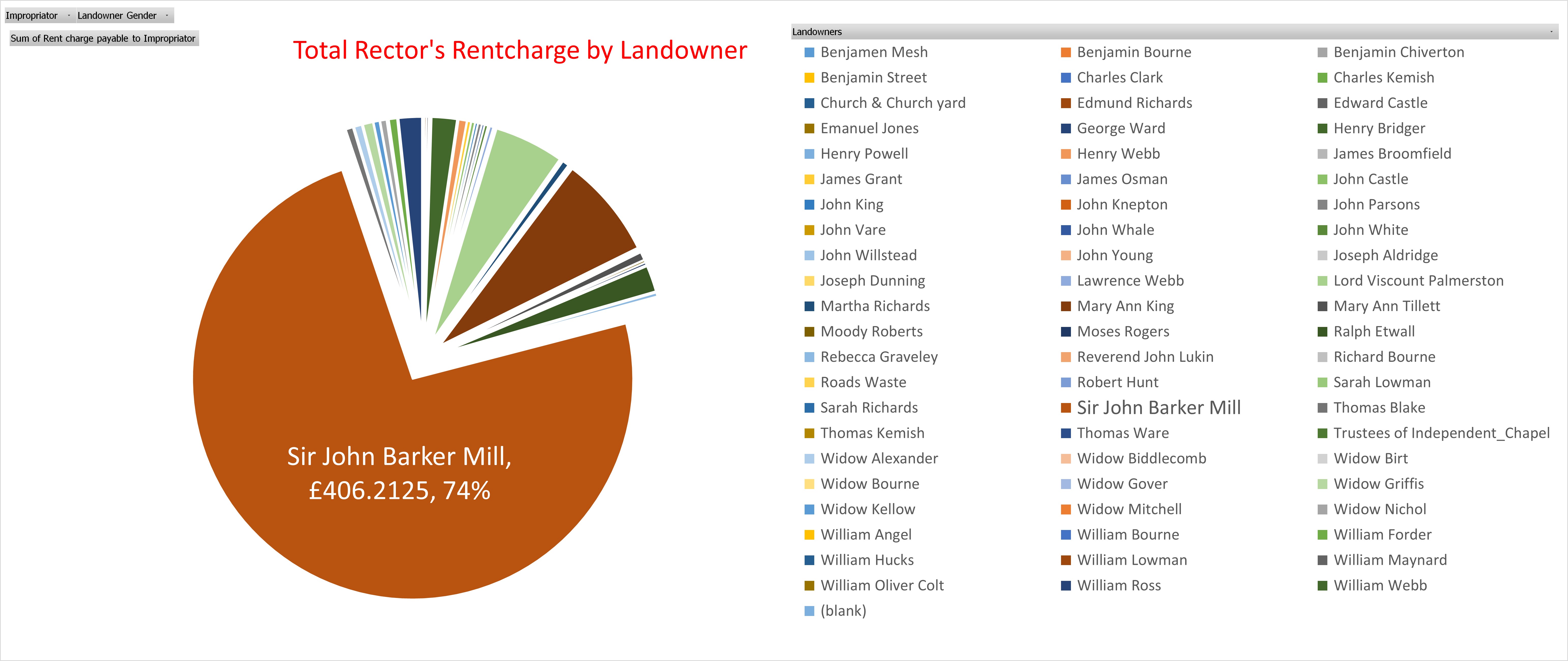
Not surprisingly, Sir John Barker Mill, being the biggest landowner, results in having the biggest proportion of Rentcharge. He also has further lands where most of the list are his lessees. Of the total rentcharge for the Parish of Nursling of £550 Sir John Barker Mill is directly responsible for approximately £406. In 2020, the relative value of £406 4s 3d from 1846 ranges from £40,220.00 to £1,467,000.00. With a relative income value of that income or wealth is £464,600.00.
We know from the Tithe Apportionment for the Parish of Millbrook that Sir John Barker Mill has substantial holdings in that parish as well as almost the whole of Nursling. In The Genealogist website, searching for Landowner and Occupier (mainly Tithe) records, for John Barker (surname) Mill in the Parish of (keyword) Nursling resulted in 497 records. Remove the keyword Nursling and replace it with Landowner, that number goes up to 2,684 results. Some of both these numbers could still be double entries, being in some instances both Landowner and Occupier. Of those results 2,113 were in Hampshire
Other Parishes it that list include, in the County of Hampshire; Broughton (6), East Dean (59), Mottisfont (530), Longstock (174), Kingsomborne and Little Sombourne (King's Somborne) (87), Stockbridge (2), Eling (537), Millbrook (255) and Nursling (461), and Whiteparish (10) in the County of Wiltshire. The total of the Hampshire identified parishes is 2111 results, so either 2 in another parish or just an anomaly.
| Parish | Count of search results | Quantity | Rentcharge V | Rentcharge R | ||||||
|---|---|---|---|---|---|---|---|---|---|---|
| A | R | P | £ | s | d | £ | s | d | ||
| Broughton | 6 | 9 | 0 | 4 | 1 | 0 | 9 | |||
| East Dean | 59 | 601 | 1 | 5 | 101 | 14 | 3 | |||
| Eling | 537 | 2355 | 1 | 33 | 86 | 7 | 06 | 179 | 19 | 0 |
| Kingsomborne and Little Sombourne (King's Somborne) | 87 | 732 | 1 | 24 | 62 | 16 | 5 | 16 | 19 | 10 |
| Longstock | 174 | 820 | 3 | 2 | 100 | 12 | 2 | 136 | 15 | 1 |
| Millbrook | 255 | 820 | 1 | 37 | 303 | 12 | 4 | 7 | 14 | 9 |
| Mottisfont | 530 | 1737 | 3 | 15 | 295 | 5 | 0 | |||
| Nursling | 461 | 2076 | 2 | 7 | 522 | 1 | 8 | |||
| Stockbridge | 2 | 2 | 2 | 9 | 1 | 11 | ||||
| Whiteparish | 10 | 33 | 2 | 29 | 0 | 5 | 8 | 2 | 5 | 8 |
| Total (10) | 2121 | 9187 | 3 | 38 | 553 | 14 | 10 | 1263 | 17 | 10 |
| 3718 Hectares | £ 553.74 | £ 1263.90 | ||||||||
This is just a quick collection with none of the checks for accuracy that are done for specific parishes. Even so, it does show Sir John Barker Mill to be a very significant land owner with about 9000 acres spread over 9 parishes in Hampshire and one parish in Wiltshire. Eling is complicated as it has multiple Impropriators and therefore multiple entries for Sir John Barker Mill in both the Schedule and in the Summary.
{slider title="Detailed Data - Landowner and Occupier Summary" class="icon"}
Detailed Data - Summary
{slider title="Detailed Summary - Schedule" class="icon"}
Detailed Data - Schedule
Your text...
{slider title="Spare" class="icon"}
Your text...
{slider title="Spare" class="icon"}
Your text...
{/sliders}
{/sliders}