")
Tithe Apportionment - Parish of Sopley, Hampshire
Introduction
Tithe Apportionment
Time for a bit of time travel. Away from the Vikings, William the Conqueror, and the Domesday Book. Not all the way to the current day but to another significant change in the rural community.
Whereas an Agreement for the COMPUTATION of TITHES in the Parish of Sopley in the County of Southampton was, on the Eighteenth day of June in the Year One Thousand Eight Hundred and Thirty Nine confirmed by the Tithe Commissioners for England and Wales, of which Agreement, with the schedule thereunto annexed, ...

A jump to 18/06/1839 form 1086 in a single leap, missing out the Inclosure Acts of 1773 et al. Sometimes known as the Enclosure Acts.
I have recently purchased a copy of the Sopley Tithe Map and Award from the Hampshire Record Office. This is the record of the Tithe Survey for the Sopley area.
Tithes were originally a tax which required one tenth of all agricultural produce to be paid annually to support the local church and clergy. After the Reformation much land passed from the Church to lay owners who inherited entitlement to receive tithes, along with the land.
By the early 19th century tithe payment in kind seemed a very out-of-date practice, while payment of tithes per se became unpopular, against a background of industrialisation, religious dissent and agricultural depression. The 1836 Tithe Commutation Act required tithes in kind to be converted to more convenient monetary payments called tithe rentcharge. The Tithe Survey was established to find out which areas were subject to tithes, who owned them, how much was payable and to whom.
From the map and award I hope to be able to locate the place of residence of some of my ancestors.
The award, which may have also been known as a living, was granted to Reverend John Parish Hammond, Clerk Vicar of the Parish, and his successors, in the sum of £330 and 10 shillings per annum in respect of the vicaraul and small tithes. The Rector, William Wyndham, of Denton, Wiltshire, and his heirs and assigns, is granted £552, in respect of the Rectoral or Great Tithes of Corn and Grain. What sort of living would that provide? Depending on how it was calculated the vicar would be on, somewhere in the range between £28,360 and £380,000. Not too shabby. The rector would fair somewhat better, not surprisingly. His income range was £47,370 to £634,700, each year. Time to read some Jane Austen again? Quite a comfortable living.
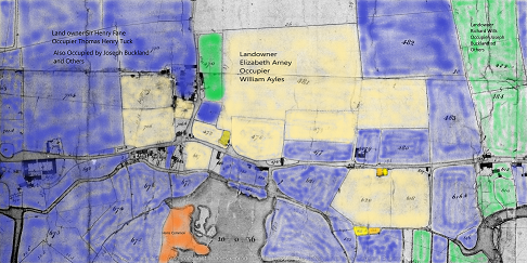
The very first entry in the schedule prompted another diversion including some therapeutic colouring in, albeit digital. The Tithe Map on the CD from Hampshire Record Office is not for reproduction. However, I have a subscription to The Genealogist and they have recently published the Tithe Survey data from the National Archives. It has predominantly the same information as the CD. However, it does provide a download button. The first entry of the Sopley schedule is a Landowner called Elizabeth Arney. She has one primary tenant and several lesser tenants. Using the tithe maps, the historic maps and internet maps, the majority of her holdings were found to be in and around Avon, in Hampshire. I downloaded the Tithe Map of Avon, part of the Parish of Sopley, and then colour washed the plots for the three major landowners in the area. There are a few plots not coloured in, generally in individual ownership.
Not quite the current fad of adult colouring in books, but similar.
I find it interesting that the large majority of the land is owned by just three people. I suspect that this is not that unusual for the period. In the Domesday Book period the Landowners would have predominantly have been the aristocracy. The blue is however a Sir, not quite blue blood, or perhaps he is. The orange represents the small amount of Common Land left after all the changes to rural life.
Elisabeth Arney owned 39 acre 1 rood 16 perch, or 39.35 acres, or 15.92 Hectares, and had to pay the vicar £4 14s 10d in Rent-Charge, each year. Together with a further £9 19s 7d to the impropriator (a person to whom a benefice is granted as their property). Is this the Rectors Share, in which case it was paid to William Wyndham.
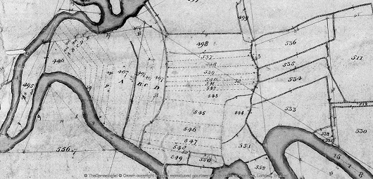
The next landowner on the schedule is George Aldridge. His middle name is either Clive or Olive. The Genealogist transcription opted for Olive. I'm more inclined towards the more conventional Clive. The easy bit is that he owns and lives at Sopley Mill. Easy to find on both old and current maps as the building is still there. The interesting thing for me is the another of his plots. Plot 497D, which is annotated as Sopley Sharphams, or something similar.
Looking at the plot on the tithe map it seems to be an area of strip farming south of his mill, on the other side of the river, not far from Sopley Common. This led me to looking for different names for strip farming and consequently a site on field systems. Open fields is one name, but that does not fit with Sharphams.
An extract of the article;-
The move towards enclosure gathered pace during the late 18th and early 19th centuries. At this time Parliamentary enclosure field systems were laid out through a series of Parliamentary Acts resulting in wholesale enclosure of land previously held within the open-field system. In total, 21% of England was enclosed by the Acts; 7 million acres of land was affected, two-thirds of which had been arable, the remainder waste. The Parliamentary fields in many ways resembled earlier regular enclosed field systems in that they were typically rectilinear/square in outline and set together, where topography allowed, with mathematical regularity.
Commons and open-field or strips were lost in this process. The strips have been replaced with fields, albeit still relatively small.
Parish of Sopley Tithe Apportionment Data Set
Although the paragraphs of this article are not dated it has been a few weeks since the last entry. I have been very busy extracting the data from the Tithe Apportionment and transcribing it into a spreadsheet. The images have detail pages and summary pages. Using both to create a form of double entry enabled me to validate my own input, and incidentally, that of the original scribes. The numbers for acres and the two rents were correct on the original and the double entry spreadsheet. There were a very few anomalies in spelling of names between detail and summary, and I opted for the detail version. One error was a tenant of Elizabeth Arney who was described as Henry Corbin in the Summary but George Corbin in the Detail. I have opted for George Corbin. I hope this will be confirmed by the 1841 Census.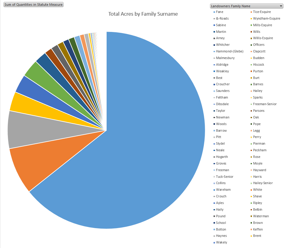
Using the spreadsheet I can now analysis land usage and ownership. See potential family ties. The total number of shops for the whole parish is amazingly low. The only industrial premises in the parish appears to be the Sopley Mill, whereas Farms abound. There are 46 plots which appear to be residences, the majority described as cottage, with some houses, farm houses, and one mansion house.
The latter being Sopley Park, which at the time was owned and occupied by George Brander Willis Esquire. George was a 1st Lieutenant in the Royal Artillery, from 17 November 1809 an fought in the Peninsular War. He was also a painter with his View of Bayonne (1814) being held in the Royal Collection Trust. Click here to see the image held at the Royal Museums Greenwich. George was the son of Revd James Willis, fought with Wellington and died on 29th August 1868, at the age of 79. He was about 20 when he became a 1st Lieutenant, and served his country in Holland, Spain and America.
However, the biggest landowner was Sir Henry Fane. He lived at plot 892, Avon Hills Cottage. the link to plot 892 is to The Genealogist website, which also holds images and index transcriptions of the Title Maps. I am a subscriber, so the link works for me, apologies if it does not work for you. I also used The Genealogist data to cross check mine if I was having trouble reading the script, or finding plots. Back to Avon Hills Cottage. I think cottage gives the wrong impression. Firstly the plot is 7 Acres 3 roods 30 perch, or 7.9375 Acres or 3.212 Hectares. That is very large for a cottage. Looking at other old maps and current Google Maps, plot 892 has Avon Tyrrel and Tyrrells Ford Country Inn & Hotel respectively. An extract from the hotel's website, 18th century Manor House hotel set in 8 acres of beautifully peaceful grounds on the edge of the New Forest. Tyrrells Ford Country Inn & hotel is situated in the Avon valley in Hampshire. Avon Tyrrel is has a rich history according to Wikipedia. Sir Henry Fane 26 November 1778 – 24 March 1840, also fought with Wellington, and had a distinguished army career, and served both as a member of Parliament and Commander-in-Chief of India. Sir Henry had holdings of about 2200 Acres across the Parish of Sopley, amounting to 64% of the Tithe area. Made up of Arable 1383.625, Meadow 302.5, Pasture 212.31, Wood 176.85, and others, across 80 tenants. The graph of Total Acres by Family Surname for the Parish of Sopley clearly illustrates the dominance of Sir Harry Fane in the Parish, and reinforces the map above with plots coloured in by landowner.
The Tice surname is next on the list, with a mear 8%. Even the Willis Family with the mansion house is just 1%, which is still a big landowner and very wealthy, just in a different league to Fane. This is only 1839, less than 200 years ago.
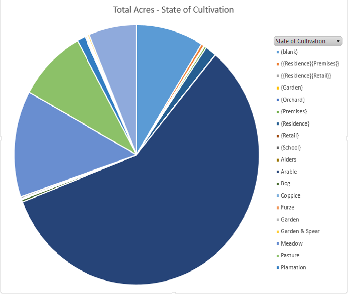
Again looking at the information extracted from the Tithe Apportionment using the spreadsheet. The graph represents the State of Cultivation recorded on the survey together with some reasonable assumptions based from the Lands and Premises data, shown in { }, with the largest being Arable 58%, followed by Meadow 13%, Pasture 9%, Wood 6%. Most definitely a farming community. The remaining significant slice of pie is (blank) at 9%, ie no recorded or implied use.
more later