A Study of the Parish of Millbrook, Hampshire
My Millbrook Parish one place study The beginning was actually just a restart triggered by a post in the Facebook group of Guild of One-Name Studies by Karen Heenan-Davies on 7 August 2018.
'I want to do analysis and maps of the BMD and census records to show how my surname Heenan changed geographically over time'
Well that got me thinking about how I had started plotting the Enumerators route of the 1841 Census of Millbrook. It was very rural then.
Link that to thoughts of GIS and BIM, and I join the conversation.
Later that day I start a new Google Map of Millbrook and using the Census images on Ancestry I start plotting the routes and key named places. I also start a spreadsheet which will expand the data extracted from the Census and also provide the upload to ESRI for the interactive ARCGIS Mapping.
Nearly a decade later and the spreadsheet has grown into a suite of integrated spreadsheets, shill growing, and becoming more complex as well as a having a wealth of historical data.
The technical approach has also changed significantly. The system is now firmly based on data. Data is used to populate ESRI StoryMaps directly with Geolocated information directly placed on the map layers. No longer, individual points placed on Google Earth or Google Maps. No more colour washing a map to indicate primary ownership. All done electronically. A separate spreadsheet for Census and another for Tithe has not been replaced entirely, but they are not integrated into a suite of spreadsheets which interact, either directly or via Power Query, for a much more robust and informative system. The derived data is fed into ESRI and here, but no longer as embedded Excel as Microsoft has depreciated that function, if not fully cancelled it. Therefore I will have to look into alternative presentation methods.
Millbrook village at least stayed within the historical County of Hampshire for the span of this story, but was in the administrative Hundred of Mansbridge, Waltham, Redbridge, Buddlesgate or Buddles Gate, the town of Southampton, and the City of Southampton. A complicated history for a static place.
This is becoming a very large article, and may take a while to load.
OPS Introduction
One place study - studies
My interest in one place studies started with the 1841 census at Millbrook Hampshire. According to MyHeritage there are only 3496 records for 1841, which increased to 12,863 for the 1891 census. Millbrook, Redbridge, and Nursling were all adjacent rural communities with very low density populations. I have been following the enumerators described roues to try to establish residences and plot them on a map. Communities were fairly static in the early part of the census taking period before WWI. There had been the earlier mass migrations caused by the industrial and agricultural revolutions, exasperated by the enclosure laws. I am expecting to find some families stay in close proximity to the first census and have a tendency to marry the girl/boy next door. Well, near neighbours. By studying one census location from 1841 to 1911, I hope to be able to shed some light on he social change as the population again starts to migrate again and the area becomes urbanised and absorbed into Southampton.
However, before the first, Millbrook, was complete, others popped along, that needed a similar treatment.
This is a collation of them as they currently stand.
Millbrook Parish one place study
One Place Study' of Whiteparish
Clarification of Scope
The are lots of complications regarding the concept of place. Millbrook, Hampshire for instance is a Manor, a village, a parish, and a suburb of Southampton. A study can not reasonably be expected to be all things to all people, all at the same time. Hence we need to set a Scope whilst recognising the boundaries move.
For our purposes, as a generalisation, the Tithe Apportionment Maps represent a good starting point. It is a well defined area with clear boundaries. It probably includes the Ecclesiastical Parish named together with any relevant Extra Parochial area. It is a stable well defined foundation in a point in time. It is not confused with Civil Parishes as they were not created until later.
This is not to ignore the time before the Tithe Apportionment, but to use it as an anchor for both forward looking and past.
Fortunately, the ancient parishes were very stable entities so it is relatively easy to project spatially backwards, with known boundary changes delt with by exception.
So the concept of the place of Millbrook for the One Place Study of Millbrook is defined by the Millbrook Tithe Apportionment Map and that is broadly static. Therefore the future fluctuations and splits all come into the scope, including Shirley, Freemantle, and Maybush, etc.
The same principle applies to the other Studies listed above. If I need to create a different interpretation I will either come back here or explain it in the particular Study..
more later
Recently added history
Recently added
A recent addition list, for the article. A new table, so not a full version history.
| Date | Description | |
|---|---|---|
| 7 May 2026 | Restructure to reflect Family History suite of spreadsheets' Timeline grouping | |
| 18 April 2026 | Added Condensed Excel generated Parish Register and Timeline in overview | |
| 16 April 2026 | Added an ESRI Domesday interactive map | Completed |
| 14 April 2026 | Restructured the layout of the article creating groups of accordions by subject | Completed |
| 13 April 2026 | Added a section for Research and Archaeology | |
| April 2026 | Populated Domesday Book period | Completed |
| 12 April 2026 | Revised Overview to include Story Map and separated into three parts | On going |
| 12 April 2026 | Updated the opening section before the read-more | |
| April 2026 | Added the OPS introduction above and this section | Completed |
| Mar 2026 | Added a section for Millbrook Manor having found a reference to an Anglo-Saxon Charter 956 | |
| Nov 25 - May 2026 | Working on integrating a suite of spreadsheets for Tithe, Census, Post Office, and other data, with particular emphasis on Geolocation | |
| Article commencement |
Note, Completed in this context, does not mean that something will never be re-visited, just that the with regard to the extent envisaged with the current about of information, it can be parked, and moved on to the next part.
Research and Archaeology
Research and Archaeology

Below, a transcript of parts of the Southampton City Council LAAP.
This document gives the sixteen Local Areas of Archaeological Potential (LAAP) as defined in the City of Southampton Core Strategy 2010. These replace Local Areas of Archaeological Importance (LAAI) defined in the Local Plan 2006. The descriptions given here are intended as a very general guide to the archaeological potential of each area and don't include all known archaeological sites and findspots. Please contact the Historic Environment Record Officer (
LAAP 1 Redbridge The area around Redbridge causeway has long been a crossing point. It is first mentioned in the early 8th century. A bridge was in existence by the end of the 10th century. There was a small medieval village alongside which seems to have been a deliberate plantation. In the post-medieval period a shipbuilding industry developed there.
LAAP 2 Nursling Plantation and Lower Brownhill Road A series of streams originate in this area, making it a likely area for prehistoric settlement. Neolithic finds have been discovered here, and evidence of small prehistoric settlements of Bronze Age and Iron Age date, notably an Iron Age settlement at Baron’s Mead. The area is adjacent to Adanac Park just outside the city boundary, where a Bronze Age settlement and Iron Age barrow/inhumation cemetery have been found, the latter of potential national importance. At Nursling Plantation, at the east end of the area, is the prehistoric earthwork known as Aldermoor Camp and surrounding land. Nearby is part of an 8th century boundary baulk.
LAAP 3 Old Shirley The village of Shirley developed at the confluence of Holly Brook and Tanners Brook, probably by the end of the 10th century. The area was an important road junction, where routes across the peninsula met routes between Southampton and Romsey. The area of Old Shirley includes Shirley Mill and the millponds, and the site of Shirley Church.
LAAP 4 Millbrook The medieval village of Millbrook was centred on St Nicholas’ Church, rebuilt in 1824 and demolished in 1939. The village developed on the main road between Southampton and Redbridge. The area includes the church and cemetery.
LAAP 7 Bannister's Park Prehistoric occupation evidence has been found across much of the area. Roman occupation evidence has been found around the Magistrates Court development in London Road/Inner Avenue and in Archers Road. In the Middle Ages this was a suburban area used for agriculture. Of interest in this respect are the farm of Bannister's Park and the village of Hill. Also included are Conduit Head, Conduit House, the medieval route and clay mine of Rockstone Lane, the medieval marker at Blackberry Mount and the site of the unfinished 18th century Polygon. The rest of Hill Lane appears in this area, as well as parts of the Avenue and all of the Inner Avenue. The Rollesbrook flows through the area, draining southwards from the Common to the Test Estuary. Near the south end of Rollesbrook is the site of Archard’s or Acorn Bridge, perhaps the bridge on the road between medieval Southampton and Redbridge.
LAAP 15 Netley Common This area is part of a Bronze Age barrow cemetery that extends beyond the city boundary. There are three known barrow sites inside the city boundary. The Roman road betweeen Bitterne Manor and Chichester crosses the area.
 An extract of Southampton CC LAAP areas
A useful Aerial Archaeology Mapping Explorer from Historic England. Not showing the Percy Road excavation yet, but too important a site to forget.
Timeline
Timeline
Timeline Focus
Social, Economic, and Migration History from 0 AD to current
NB Social, in this instance, includes major religious.
Not particularly focused on Kings and Queens, inventions, science, wars, celebrities.
Also administrative areas
Placeholder for DATA
The Story of Millbrook
Including Shirley, Redbridge, Freemantle, Wimpson, and Hill.
Starting with the Anglo-Saxon Charter in 956 creating the Manor of Millbrook. See it after the Overview.
Generally in four parts, Overview, Timeline, Records, and Other.
Overview including StoryMap
Overview
AKA Summary, Executive Summary, Conclusion
However, as this has morphed due to adopting different techniques, with different presentation outputs, it is worthwhile creating some separation here.
ESRI Story Map
Condensed Timeline
Core Register Data
 |
 |
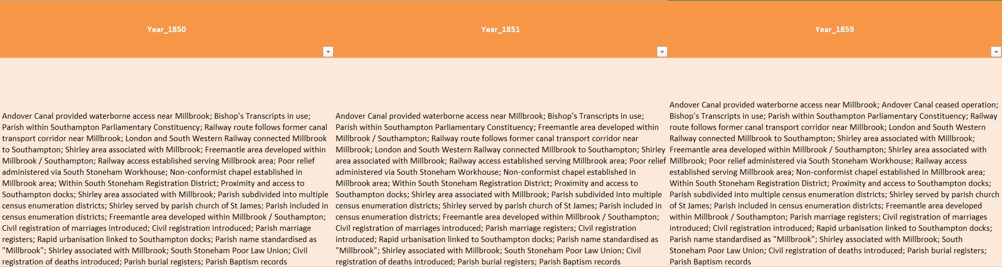
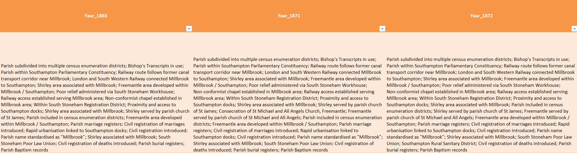
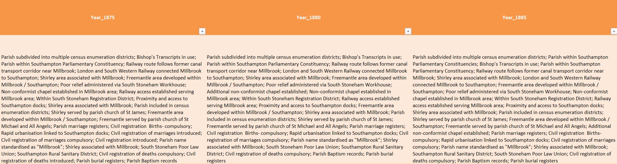
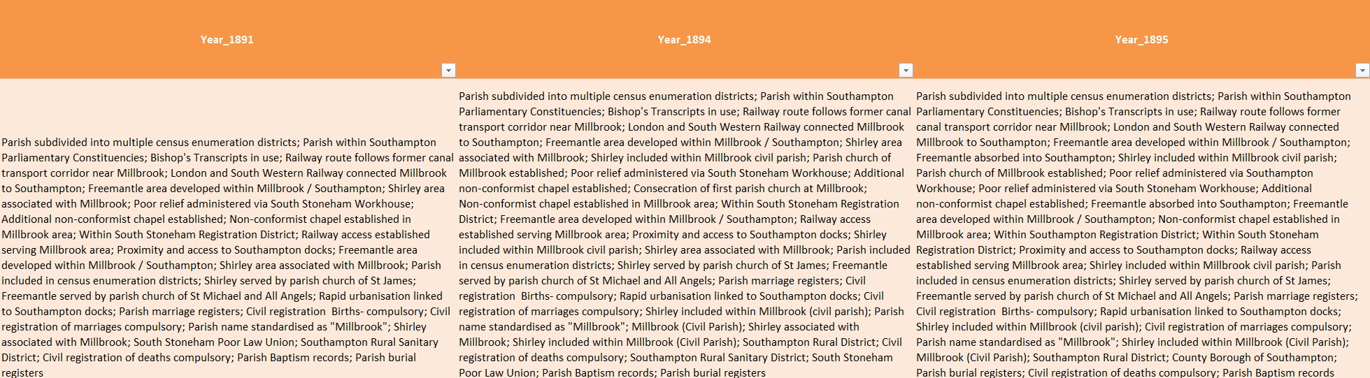
Timeline by Years
This is not a normal timeline. Firstly, the years in the title row are generated out of the change events. A change has a year, which creates a column. Also it is a slice of time timeline, not a sequential one, For each year in which there is a column, the text states all that is still relevant for that year, not just the event of that year.
Accordingly, it is more suited to looking up what applied in a particular period, than a long line sequence.
Disappointingly, these are screenshots, and accordingly do not update when the source is amended. I understand that Microsoft is in the process of depreciating the ability to embed parts of Excel Spreadsheets into websites.
 |
 |
 |
 |
 |
 |
 |
| |
 |
 |
 |
 |
 |
 |
 |
Overview data centric method
Overview - Additional Overview using the revised data centric method
Not written yet
Overview Google method
Overview - Initial Overview based on the Google Method, still relevant.
Geolocation based on Google Earth Pro, Google Earth Pro Project, and Google Maps
Obviously it is not that easy a task to locate things mentioned on an 1841 Census and plot them on a current Google Map. My process varies but the simple version is;-
- Can the place still be found on current mapping? If so use that data to plot on my map.
- Try to locate the place on a Ordnance Survey map of the period, either paper or those digitised maps held my the National Library of Scotland Mapping. There are other sources of OS maps, but this one is free to use.
- Compare the location of the found place with current maps, there is a slider to change the transparency of the old to new maps on the NLS georeferenced maps, as well as a 'Spy' button.
- Search the internet for additional data, either prime or as corroboration.
- I use Grid Reference Finder to translate any location data into Latitude Longitude and to check the satellite image to ensure correct positioning.
- I create layers on my map to correspond to the Census Enumerator Districts.
- I use the search by inputting the Lat Lon (cut and paste) to find the position and plot the pin onto the map in the appropriate layer.
All of this is just to get an understating of the Census walk or route, to help provide location information to each of the homes recorded on the Census.
But it is not even that easy as some names are not to be found. For instance Turnpikes turned into their own mini study with it's own article on this site.
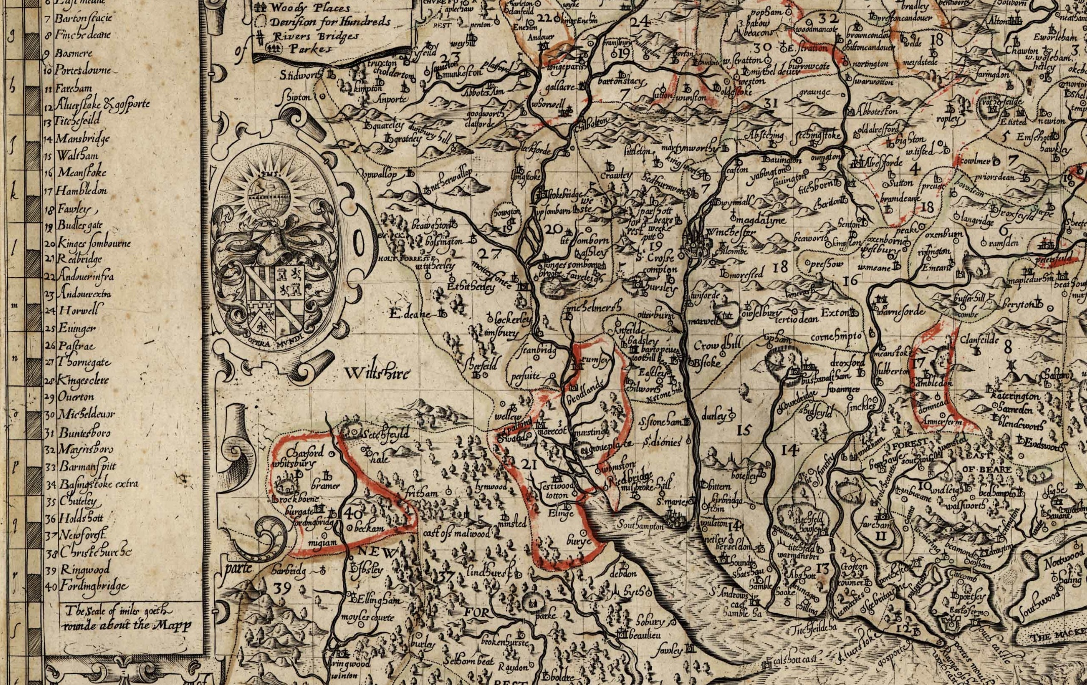
The map below is the result of adding Turnpike data of the area to a current Google map, and any information found so far.
The map can be enlarged by the icon top right and a menu shows with the icon on the top left. Layers with information on Turnpike roads and tollhouses, as well as individual Census Districts can be turned on or off.
It is commonly accepted that places and maps change over time. This is further complicated by shorelines changing, mudflats becoming docks and canals becoming railway lines or backfilled. District one has all of these problems. An old 1871 OS map shows all of the old positions. Some of these are approximately replicated on the My Maps.
The canal in question is of the Southampton and Salisbury Canal Company and there are photos of the locations together with the plan, old, and current maps. There is also a map of the area in the British Library.
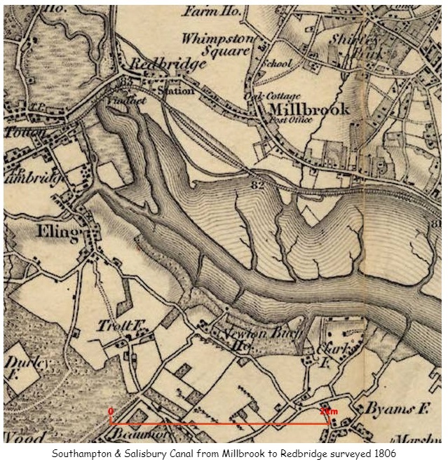
The above map not only shows the canal but also other places around Millbrook including Whimpston Square, which correlates with Wimpston on later maps and a road called Wimpson Square on a 1911 Census record for a family called Street.
The link to the British Library held maps provided invaluable additional information including additional information about names and locations of Turnpike gates to confirm or correct data sourced elsewhere.
A named boundary of the 1841 Census is Cockerwood Land, in District 6 for instance. However, I have not found that road on any current map. There is some reference to Hill Lane on a paper about Taunton's College and a Cockroads Farm shown on some of the old OS Six inch maps.
'A map of Southampton in 1800, by Doswell shows a building next to Hill Lane and known as Cockerwood House. The first OS map of Hampshire shows an unnamed building within a rectangular enclosure. The details are very similar to those shown on the 1826 map of Hampshire. The enclosure map of Hill and Shirley in 1830 shows two main building complexes, both aligned north–south, one adjacent to Hill Lane and the other, to the north-west of it, set slightly back from Hill Lane. This second building interrupts a rectangular enclosure that otherwise surrounds the building on Hill Lane.'
OS 1866 Map Link There is also a short article on Sotonopedia There is also relevant information on OS First Series Map showing Whithedswood Common. Even more interesting is the British Library held map. This map appears to predate the OS First Series and includes Shirley Common, Warren, Shirley, Hill, Whiterswood Common, Cock Road, Shirley House, as well as Millbrook and Redbridge. Whilst the map does have the words Shirley House it is not clear exactly where it is. Possibly somewhere close to Foundry Road. Later maps pin point Shirley House, which in turn suggests that what appears to be Shirley Brick, on the 1806 map above is in fact Shirley Park.
Unsurprisingly, research into one area takes you to another. The Parish of Millbrook on British History Online leads to manors of Millbrook, which again leads to the Manor of Shirley, and latterly Shirley and Hill. This article provides some of the names of the Lords of the Manor in the 13th and 14th Centuries. I will add these names to my One Place Ancestry Tree, The people of Millbrook. Sometimes the entries produce hints and additional information about the person and their family. The most successful of these so far was the Whitehead family who held the the Manor of Shirley and Hill from 1433 until Mary, the daughter of Henry and Mary, married Alexander Thistlethwayte in 1717, and the manor thus passed to the Thistlethwaytes with whom it remained for a further considerable period. Whilst they were holders of the Manor of Shirley and Hill, their main seat appears to have been in Norman Court, West West Tytherley, Hampshire, on the border with Wiltshire. Indeed, Norman Court Park is shown on the OS Map as being the boundary between Hampshire and Wiltshire. Norman Court Park is about 20 miles away from Shirley, so I am unsure if they ever lived in Shirley House. Further investigation quickly reveals that Shirley House was built in the later part of the 18th century for retired West Indian plantation owner, Richard Wilson. It stood at the junction of modern-day Clarendon and Henty Roads. The site is bisected by modern Shirley Park Road, which was named after the estate. Sales particulars of 1792 show it to be a substantial dwelling, with double coach houses, stabling for eight horses, pleasure gardens, a small farm and a large paddock, the total comprising about 48 acres. In 1802 it was occupied by the Reverend Sir Charles Rich and it remained with that family until 1836, when it was sold to property developer William Henry Roe. Roe eventually sold off the estate for development and the house was demolished in the 1880s. More names to add to the Ancestry Tree.
Information on Manors can also be found at the National Archives. The search for Millbrook manor reveals 34 collections held in 4 archives with a date range of 1189 to 1925. Some of these also refer to Nursling Manor, perhaps as the main manor of the two, with some records held at Winchester. Hampshire County Council in the form of the Hampshire Records Office also has a significant number of records, including for instance;-
Plan of Hill and Shirley manor (Whitheds Wood), Millbrook, property of Robert Thistlethwayte, 1778; plan of Hill and Shirley enclosure, 1830; mortgage of tenement on south side of Winchester, John Osman to Elizabeth Merriweather, 1694.
If Nursling Manor and Millbrook Manor are so linked in court records, should I expand my One Place to be Nursling and Millbrook, or add a Nursling One Place Study. The latter is the selection made. Both are registered with the Society of One Place Studies, as Millbrook One Place Study and Nursling One Place Study..
Whilst some of the previous holders of the Manor of Shirley have also been Mayor of the adjacent town, the list of Mayors of Southampton does not include a Whitehead.
The Ancestry tree now includes many generations of Whitehead due to this. Also, I have created an article about Shirley on this site.
Off I go on another side road. From Shirley House or Park, the trail leads me to THE COUNTRY HOUSES OF SOUTHAMPTON By JESSICA VALE. Another paper by the Hampshire Field Club and Archaeological Society. However, perhaps this is not quite so much of a diversion. Some of the early Census Enumerators record the route taken by reference to the large houses of the time, whilst others just record something like 'Shirley Common' for almost the whole of the census. The latter not entirely helpful in establishing locations of dwellings. Even so, sometimes historical papers of old houses reveal the names of the occupants which can be correlated to the census.
The occupancy of Shirley House by the Rich family led me to another long line in Ancestry, then confirmed by other sources.
The Rich Baronetcy, of Shirley House in the County of Southampton, was created in the Baronetage of Great Britain on 28 July 1791 for Reverend Charles Rich. He was the son-in-law of the fifth Baronet of the 1676, and had inherited the estates and assumed the name and arms of Rich. This creation became dormant upon the death of the sixth Baronet in 1983, but heirs are still thought to be living. From Rich baronets.
Another source was the Dictionary of National Biography, Volumes 1-22.
The Rich Baronetcy, of London, was created in the Baronetage of England on 24 January 1676 for Charles Rich, of Mulberton, Norfolk, with remainder to his son-in-law and distant cousin Robert Rich, son of Nathaniel Rich, who inherited the baronetcy the following year. He was a successful politician. His younger son, the fourth Baronet, was a distinguished cavalry officer. The title became extinct on the death of the sixth Baronet in 1799.
Looking into a Nathaniel Rich 1585-1701 takes us into the English Civil War and the formation of the New Model Army. Nathaniel became Colonel of a regiment of horse upon the formation of the New Model Army and was therefore among the first of our professional Army. He fought on Cromwell's side against the King.
I wonder, is the fact that the formation of the current professional army traces back to the Parliamentarians, the reason why it is not a Royal Army, it the way that Royal Navy and Royal Air Force are.
I have just found a possible source of tithe maps of the parishes of Hampshire. This has the potential to significantly aid the correlation of places and families in the 1841 census.
Two interesting metrics I am trying to include into my spreadsheet are voting and adulthood status which requires date thresholds. An interesting summary of the English path to democracy is on the National Archives site.
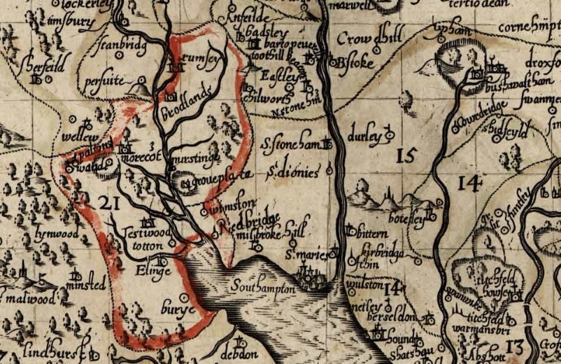
In my meanderings around the Fifield family and the Standbridge Estate, I found the name Humby, and I have a later relative William Edward Humby 1831-1906; father-in-law of 2nd great-aunt who lived in 1 Rose Hill Cottages, Romsey Road, Old Shirley, Millbrook, Hampshire, England. I have found him in the 1871 Census which I have plotted the Enumerators route and William's home on the map below.
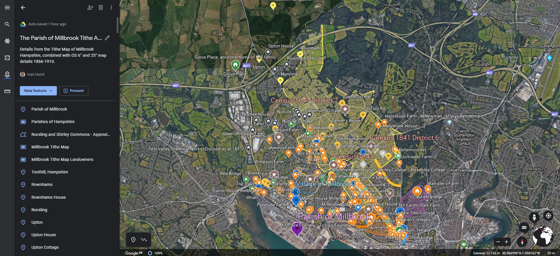
One of the interesting and challenging aspects of plotting locations found in Census returns is the passage of time has eradicated a large number of the buildings and places mentioned. Therefore they cannot be directly plotted onto a current map. Even some current roads were previously known by another name. Reference to old maps helps to resolve some of the locations. It is a slow process, but a worthwhile investment in time and effort. The map below is a collection of places found and plotted. It is still growing, and becomes the basis of Census Enumeration route plots, which in turn will feed data into an ESRI data map.
Another interesting, albeit sometimes unlikely, source of information, is Facebook. There is a group called Freemantle Local History Group. It is fascinating. It is a private group so although I have included links to information sources they may not open for you.
Cedar Lodge House, off Oakley Road, was built in the mid nineteenth century. It was originally called Mussoorie Villa (after a place in northern India). Nearby 2.68 acre Cedar Lodge Park named after the house opened in 1967. Oakley Road was originally called Mousehole lane, renamed Oakley Road in 1909 in honour of the then Mayor, Richard Garrett Oakley.
Another link in the group led me to a collection of Old Maps of Hampshire.
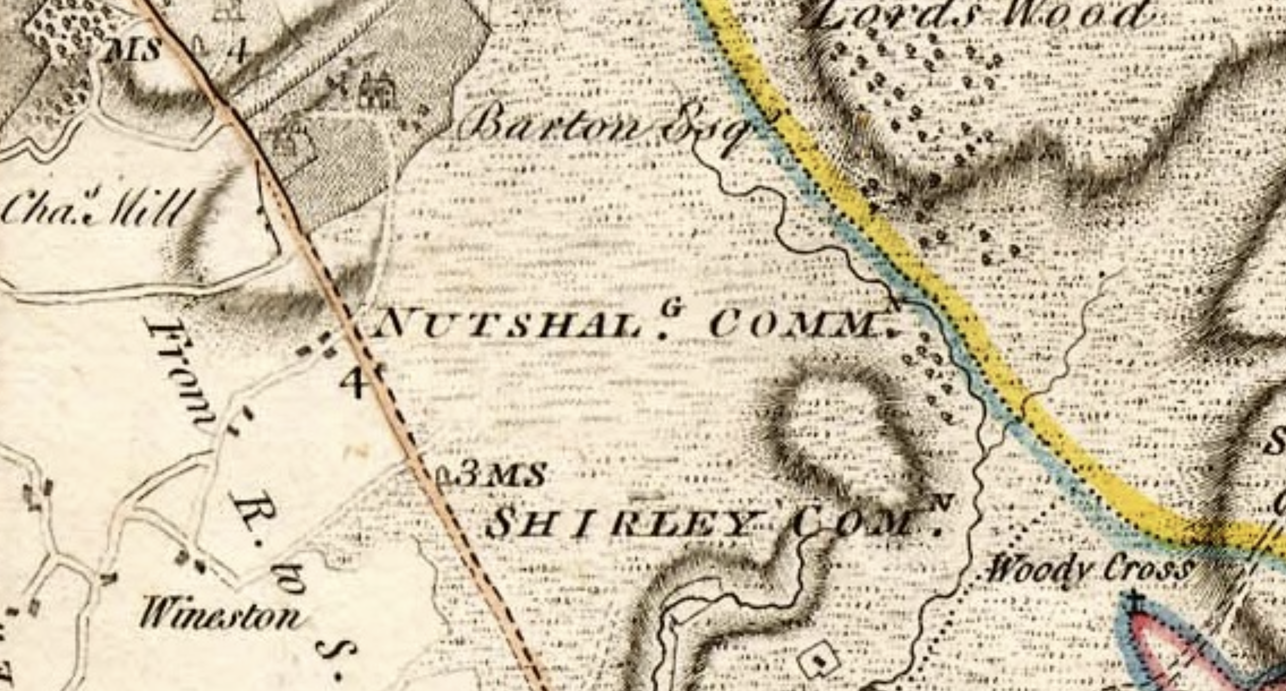
Milne's Hampshire 1791 section 43
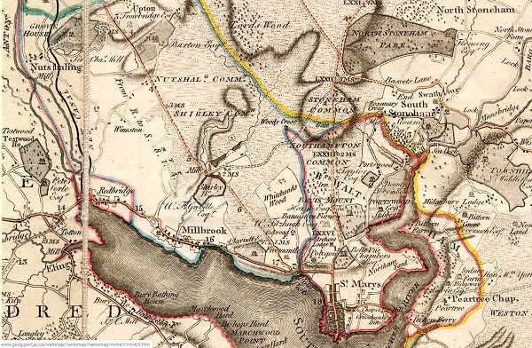
The map shows how rural the whole area was in 1791, with the majority either estates or a huge area of common land. The estates appear to have the names of the owners associated with them. J Jarrett Esq was annotated above Freemantle Park. The size of Nutshalling Common, Shirley Common, and Whiteheads Wood is amazing. So much land in Common usage. Just a few years later the impact of the agricultural and industrial revolutions were clear to see. On the one hand, it is a major land grab by the establishment and the wealthy, but on another it is increasing the productivity of the underutilised and uncared for land, to feed an expanding population. Name changes are also an important consideration. Nutshalling has previously been Nhutscelle, Hnutscilling, Nutshullyng and is now known as Nursling. Whiteheads Wood on this map becomes variously Whitheds Wood, Whithed Wood on later maps. Whithedswood Road becomes Shirley Avenue. Wynsor is shown on this map as Wineston and is now Wimpson. Old roads such as Romsey Road are clearly shown and are still evident whilst Millbrook Road, whilst on a similar alignment but considerable developed. Turnpikes have also come and gone. Shirley is recorded as a manor with a mill in the Domesday Book; the mill standing to the west of the present Romsey Road/Winchester Road junction, at the confluence of the Hollybrook and Tanner's Brook streams. Shirley Mill had three large ponds, to the north of Winchester Road. One of the three mill ponds remains today, accessed by following the Lordswood Greenway. The mill can be seen adjacent to Shirley House and both Hollybrook and Tanner's Brook streams can be seen meandering towards the mill through Nutshalling and Shirley Commons.
Another Map, Taylor's Hampshire 1759 section 43
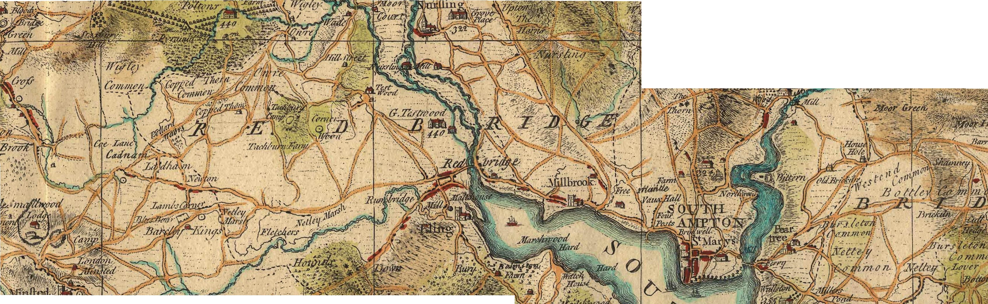
Millbrook is clearly shown on this map, with Freemantle, Vaux Hall, and Four Posts between it and Southampton. Mouse over the image to zoom in to Millbrook. Grove Place and Nursling is at the top the map. Shirley, despite being mentioned in the Domesday Book is not identified on this map.
Shirley was a settlement in Domesday Book, in the hundred of Mansbridge and the county of Hampshire.
It had a recorded population of 12 households in 1086.
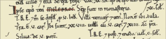
Land of Ralph of Mortimer
Households
Households: 4 villagers. 3 smallholders. 5 slaves.
Land and resources
Ploughland: 8 ploughlands. 2 men's plough teams.
Other resources: Meadow 12 acres. Woodland 6 swine render. 1 mill, value 2 shillings and 5 pence. 1 fishery. 1 church.
Valuation
Annual value to lord: 5 pounds in 1086; 5 pounds when acquired by the 1086 owner; 5 pounds in 1066.
Owners
Tenant-in-chief in 1086: Ralph of Mortimer.
Lord in 1086: Ralph of Mortimer.
Overlord in 1066: King Edward.
Lord in 1066: Cypping (of Worthy).
The Domesday Book records a church being present at Shirley in 1085, but on 1 May 1574 the parish of Shirley was amalgamated with that of Millbrook as the small Shirley congregation could not afford the upkeep of the Shirley church building. The Shirley church was demolished in 1609, with stones from the old building used to enlarge St Nicholas' Church building in Millbrook.
By 1836, the population of the combined parish had reached 2,375 inhabitants, and the old Millbrook parish church was too small. Land was donated for a new church building in Shirley by Nathaniel Newman Jefferys, and Church Building Society combined with private funding to pay for the structure itself. The new church, dedicated to St. James, was designed by local architect William Hinves and consecrated on 20 August 1836 by the Bishop of Winchester with a large crowd present despite "unfavourable weather", according to the Hampshire Advertiser newspaper.
Some extracts from a paper presented to Hants Field Club entitled FIELD SYSTEMS AND ENCLOSURES IN HAMPSHIRE
Hampshire was among the counties reported upon by Wolsey's Commission in 1517.
... 37 Hundreds and eight liberties at which the County (including the Isle of Wight) was divided. The Hundreds for which enclosures are recorded are :
Basingstoke, Crondall, Kingsclere, Mansbridge, Odiham, Redbridge, Shutterley (i.e. • Chuteley) and Somborne, and the places. mentioned are : Al( d)ington recte Aldington, Bewraper (Beaurepaire), Bramsyll " Breche and Sockborowe " (field names only ?),. Dogmersfelde (Dogmersfield), Erleston (Earlston), Ewurst. (Ewehurst), Farley . (Fafleigh Chamberlayne),- Ichill, " Loke Dewer," " Newtosberye," Wynsor (in Millbrook Parish ?), and the total area is some 562 acres.
Hampshire is not included among the 14 counties covered by the Depopulation Act of 1536, though curiously enough the Isle of Wight is.
The County Agricultural Survey was written by the. Drivers, who describe themselves as " of Kent Road, Surrey." They are sorry to observe in the County such immense tracts of open heath and uncultivated land, which tend to remind the travellers of voyages among the barbarians ; they point out, however, that in this respect Hampshire is no worse than Wiltshire and Dorset, perhaps a trifle better. This is no excuse for it. Near Southampton is a great deal of open land which if enclosed and cultivated will give good crops of corn. There are large downs towards Fareham and Warnford,85 and much open land with some good down near Petersfield. As to the forests and wastes, the Drivers are astonished that the Crown Lands in particular should have remained so long in a state of neglect. If properly managed they would pay much of the interest on the National Debt. A general Act should be passed at once, preferably entrusting enclosure to the Commissioners of Crown Lands:
As to other open land, it might well not be worth enclosure for tillage, and still be worth taking in for planting. No " gentleman can sit down easy, and say he has discharged his duty to his family when he is conscious he has neglected to pursue those measures, which, in a few years, would increase his property so amazingly." . Commonable land of every kind can be regarded as little better than waste, since everyone exhausts it, and no one pays the least • attention to. its support and improvement. "All this would be easily remedied by a general inclosure bill, which would reduce the expense. of inclosures, and would be a spur to that improvement." Wool production would certainly not decrease on enclosure, every farmer in his own interest keeps as many sheep as he is able, and he can feed twice as many on land in severalty as on the corresponding area in common.
Note the reference to Depopulation and read more about it here. By 1530 the population of England and Wales had risen to around 3 million. At the end of the 17th century it was estimated the population of England and Wales was about 5 1/2 million. The population of Scotland was about 1 million. The population of London was about 600,000. London went on to become the biggest city in the world for a while. In the 19th century Britain became the world's first industrial society. It also became the first urban society. By 1851 more than half the population lived in towns. As our population approaches 70m it is interesting to think of depopulation efforts at 3 million! The maps of Millbrook clearly show the urbanisation of the countryside.
Following the Tithe Commutation Act 1836 Tithe Maps were produced which recorded both the Landowner and Occupier for most lands. From the Tithe Apportionments records it is apparent that on 4th March 1843 Lady Hewitt
was both the Landowner and Occupier of Plot 875, Freemantle Estate, described as House Offices and Pleasure Grounds, with an area in statute measure 6,0,2, about 2.4 Hectares.
Nathaniel Newman Jefferys was both Landowner and Occupier of Plot 825 described as House Offices and Garden, an area of 2,2,24 imperial, on 4th March 1843. However, one plot does not show the full picture.
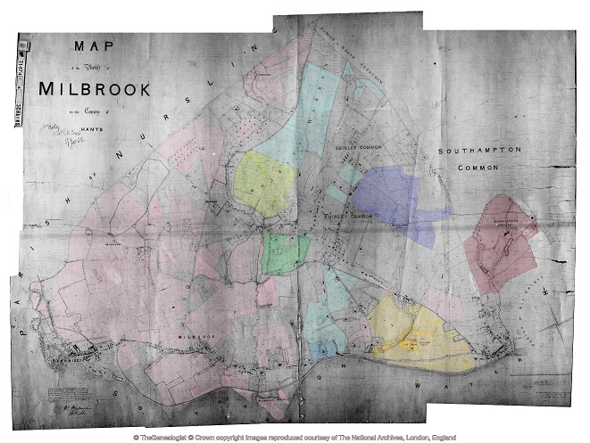
Using the Tithe Apportionment map of the Parish of Millbrook, Hampshire, as a base, I have colour washed some of the plot landowners. The Freemantle and Banister Estates, pale orange and brown respectively can be clearly seen. The landowners in 1843 where Lady Hewitt and Reverend William Fitzhugh. Shirley Park, owned by William Henry Roe, is in green. Blightmont Lodge, occupied by Lady Lisle, just north of Millbrook Road, and part of the larger Berrywood estate owned by Nathaniel Newman Jefferys is shown in a slightly darker blue than the light blue of the rest of the estate. It appears that Nathaniel Newman Jefferys has bought a large swath of the newly released Shirley Common land in the area of Shirley Warren. Clement Hoare & William Dunn seem to have also taken advantage of the inclosue of Shirley and Nutshalling Commons, as joint owners of plots coloured lime green. Roads such as Warren Avenue, Warren Crescent and Tremona Road have already been laid out for the impending urbanisation. However, the biggest landholding in the Parish, by a long way, is Sir John Barker Mill and various associates who together are landowners of the pink coloured plots, mainly farmland in 1843, but destined to be developed and absorbed as suburbs of Southampton.
Greenwood's Hampshire 1826 section 53
Moving into the current, the Church of England has a database of interesting statistics about all the Parishes in the country. Below is the Map which covers the original Millbrook Parish and shows the current Parishes of;
Millbrook: Holy Trinity
Freemantle: Christ Church (1851)
Shirley: St James (1836)
Maybush.
Click on the parish to bring up the statistics.
The Parish of Millbrook Tithe Map 1843 including Shirley, Freemantle and Four Posts, layered onto Google Earth Pro and Geolocated. Same base map as the coloured ownership map. Over 20 separate tiles or files to fit spherical base globe of Google Earth. All adjusted to best fit the projection, and align roads and as many details as possible. Below is just an image of the result. Google Earth Pro is desktop based so does not lend itself to sharing. However, using transparency of the layers I can locate buildings on the tithe map and see what is there now. I can also use the Lat and Lon and show on Google Maps to georeferenced individual buildings or plots.
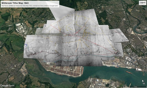
The interactive version is created using a Project in Google Earth and can be seen here, The Parish of Millbrook Tithe Apportionment. Using the Tithe Map plotted on Google Earth Pro above and other maps, I have placed some of the Property names onto a Google Earth Project with an up to date backdrop. History mapped to now.
A screenshot as at March 2020. Work ongoing.
Freemantle
Freemantle Estate
Narrative
Broadly in chronological order but with some exceptions.
Prehistory
Prehistory
Palaeolithic, Neolithic, and Bronze Ages.
Pre-Roman before 43AD
Pre-Roman before 43AD
Roman - 43 to 410AD
Roman Occupation - 43 to 410AD
Early Medieval - 411 to 899AD
Early Medieval - 411 to 899AD
High Medieval - 900 to 1349AD
High Medieval - 900 to 1349AD
Millbrook Manor
Millbrook Manor
Anglo-Saxon Charter of 956
The Anglo-Saxon Charter of 956, specifically the grant of 7 hides (cassati) at Millbrook, is a significant document that provides insight into the ancient boundaries of the Manor of Millbrook. This charter, which is part of the collection of Anglo-Saxon charters, includes a haga in Southampton, Hants, and is printed in Latin with English bounds. It is a valuable source for understanding the historical context and legal framework of the time.
S 636
The Sawyer number for the charter referring to Millbrook Manor from A.D. 956 is S 636. This charter was granted by King Eadwig to Wulfric, his princeps, and includes details about the grant of 7 hides at Millbrook..
The listing in The Electronic Sawyer, the online catalogue of Anglo-Saxon Charters
S636 A.D. 956 (ii). King Eadwig to Wulfric, his princeps; grant of 7 hides (cassati) at Millbrook, with a haga in Southampton, Hants. Latin with English bounds, Winchester, Old Minster
- Endorsements: (1) in a contemporary hand: + ˇis is ˇara . VII . hida boc æt Melebroce ˇe Eadwig cing gebocode Wulfrice his ˇegne on ece yrfe . (2) in a hand of late s. xv: VII hyda in Mylbrooke . saxon . Px Anno heroicæ incarnationis DCCCCLVI . Indictione . XIIII . Eadwig numine cælesti gentis Geuuisorum orientaliumque nec non occidentalium simul etiam aquilonalium Saxonum archons cuidam meorum principum quem nonnulli vocitant noto vocamine . Wvlfric . VII . cassatos perpetualiter trado . illic ubi vulgariter dicitur . æt Melebroce . quandiu hic corpus animatum habere videbitur nostri doni privilegium sibi vendicet et postero denique suo quemcumque elegerit pereniter impertiat cum campis . pascuis . pratis . silvis . Hæc tellus a cuncto sit immunis servitu nisi pontis . et arcis . ac expeditionis juvamine . Si quis autem infringere temptaverit quod absit . sciat se rationem redditurum coram Deo et angelis ejus . nisi prius hic digna satisfactione emendare satagerit . Istis terminis ambitur prædicta tellus . ˇis synt ˇa land gemæro to melebroce . ærest of hreodbrycge 7lang st'r'æte on fearninga broce 7lang mearce on melebroces ford east 7lang mearce on ˇunres lea norˇeweardne ˇonon 7lang weges on cinges dic ˇonon 7lang mearce on holan weg of ˇam wege on ˇa ea oˇ midne stream 7lang streames on hreodbrycge . 7 se haga an ham tune ˇe ˇærto gebyret . + Ego Eadwig rex Anglorum indeclinabiliter concessi . + Ego Eadgar ejusdem regis frater consensi . + Ego Oda archiepiscopus cum signo sanctæ crucis + roboravi . + Ego Ælfsinus presul sigillum agiæ crucis + impressi . + Ego Oscytel episcopus consignavi . + Ego Osulf episcopus adquievi . + Ego Wulfsige episcopus subscripsi . + Ego Byrhthelm episcopus conclusi . + Æˇelstan dux . + Eadmund dux . + Byrhtferˇ dux . + Ælfhere dux . + Ælfsige minister . + Wulfric minister . + Æˇelgeard minister . + Ælfheah minister . + Ælfgar minister . + Byrhtferˇ minister . + Ælfred minister .
- Translation by Google ...
- ˇis is ˇara . VII . hida boc æt Melebroce ˇe Eadwig cing gebocode Wulfrice his ˇegne on ece yrfe . (2) in a hand of late s. xv: VII hyda in Mylbrooke . Saxon . Px Year of heroic incarnation DCCCCLVI . Indictione . XIVII . Eadwig the celestial god of the Geuuises, the eastern and western Saxons, together with the northern Saxons, archons of some of my princes, whom some call by a well-known name . Wvlfric . VII . I hereby permanently cancel . where it is commonly said . æt Melebroce . as long as he appears to have an animate body, he will claim the privilege of our gift and finally grant it to his posterity whomever he chooses, with fields . pastures . meadows . forests . This land shall be immune from all service except for the bridge . and the castle . and the aid of the expedition. But if anyone attempts to infringe, which is far from it. Let him know that he will give an account before God and his angels. Unless he first makes a worthy amend here with satisfaction. The aforesaid land is encompassed by these terms. This is the land of the gemæro to melebroce. The east of Hreodbrycge is on the east of Fearninga Broce. The east of Melebroces is on the east of Unres Lea Norˇeweardne. Ononon is on the west of Holan Weg of Am Wege on the west of Midne Stream. He shall do this and do this. + I, Eadwig, king of the English, have granted it without hesitation. + I, Eadgar, brother of the same king, have consented. + I, Oda, archbishop, have strengthened it with the sign of the holy cross. + I, Ælfsinus, presbyter, have impressed the seal of the golden cross. + I, Oscytel, bishop, have signed. + I, Osulf, bishop, have agreed. + I, Wulfsige, bishop, have subscribed. + I, Byrhthelm, bishop, have concluded. + Æˇelstan, duke. + Eadmund, duke. + Byrhtferˇ, duke. + Ælfhere, duke. + Ælfsige, minister. + Wulfric, minister. + Æˇelgeard, minister. + Ælfheah, minister. + Ælfgar, minister. + Byrhtferˇ, minister. + Ælfred, minister
There are some places named:- The east of Hreodbrycge is on the east of Fearninga Broce. The east of Melebroces is on the east of Unres Lea Norˇeweardne. Ononon is on the west of Holan Weg of Am Wege on the west of Midne Stream.
- Hreodbrycge is probably Redbridge.
- Fearninga Broce
- Melebroces
- Unres Lea Norˇeweardne
- Ononon
- Holan Weg
- Am Wege is probably Hamtun, later Southampton
- Midne Stream.
More information in King's College London ASChart (but it has not got to S636 yet)
A hide is equal to approximately 120 acres. Historically, this measurement was used to denote the amount of land sufficient to support one household, with most counties recognizing it as 120 acres. Hence 840 acres for Millbrook Manor, (about 340 Hectares) and that size is before the addition of Shirley.
According to an Anglo-Saxon Charter of 956 Aldermoor, Lordswood, Lordshill and Coxford are all within the ancient boundary of the Manor of Millbrook.
Information on Manors can also be found at the National Archives. The search for Millbrook Manor reveals 34 collections held in 4 archives with a date range of 1189 to 1925. Some of these also refer to Nursling Manor, perhaps as the main manor of the two, with some records held at Winchester. Hampshire County Council in the form of the Hampshire Records Office . Which also has a significant number of records, including for instance;-
Plan of Hill and Shirley manor (Whitheds Wood), Millbrook, property of Robert Thistlethwayte, 1778; plan of Hill and Shirley enclosure, 1830; mortgage of tenement on south side of Winchester, John Osman to Elizabeth Merriweather, 1694.
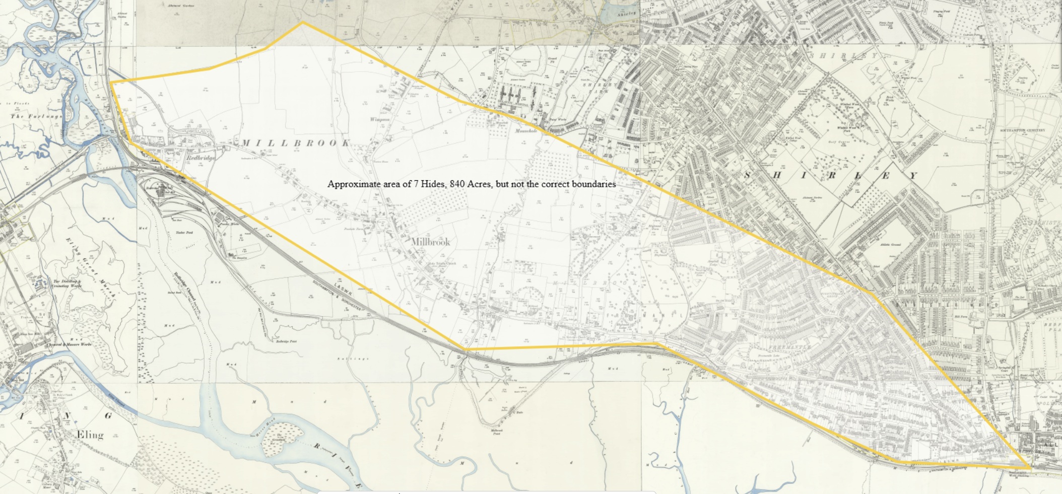
An old OS 25" map, including Millbrook with an area of approximately 7 Hides, 840 Acres, superimposed on the map. Just to give an idea of the size of an award of 7 Hides, with no intention to imply or state the location of the boundaries of the Manor of Millbrook after 956.
Currently, my research has not found any evidence of a Manor House or Church of that period, or location of. Both a Manor House and St Nicholas's Church can be seen on the much later map. See pins on map below.

Both the Manor House and the church indicated above are on the route of the new(ish) Millbrook Road dual carriageway, so I suspect the Manor House was not that old, and St Nicholas's Church had already been demolished following the building of its replacement, Holy Trinity Church, near the Manor House. The later church is still there.
Although, perhaps it was older than I thought. In the decades after the war, the Establishment was not as concerned with preservation as it is today.
Manor house shown and named on 19th and early 20th century Ordnance Survey maps and probably also shown on late 18th century mapping. The house was part of the village of Millbrook (MSH3132), but some way to the west of the now-demolished medieval church. The building had been demolished by 1947 and the grounds obliterated. The site is now part of an industrial estate.
Some medieval and post-medieval artefacts were found during archaeological investigations at Unit 1, Third Avenue in June 2017 (SOU 1757). The artefacts were found in a buried garden soil, probably associated with the grounds of the manor house. Some ponds and drainage features were also found, one of which may have been within the grounds, and another on the south boundary of the grounds.
HER 5/2/2020: See MSH5866 for the results of this fieldwork. The north part of the site lay within the former grounds of Millbrook Manor House, although the south part had probably been fields. The manor house itself lay to the north. The evaluation trenches recorded some ponds and drainage features shown on OS mapping to 1947. One of these may have been in the manor house grounds, and another was on the south boundary of the grounds. In the north part of the site, a buried topsoil or garden soil overlay natural deposits; this was probably associated with the former manor, being the ground surface prior to WWII. The buried soil contained a few late medieval and 17th century finds, and a tile fragment of possible Roman date, although most of the finds were late post-medieval to modern. Above the buried soil, and filling the ponds and drainage features, was a considerable depth of modern made ground; the 1947 map shows the area being used as a rubbish tip. By 1952 a new building had been constructed on the site.
Unfortunately the agreed evaluation trench locations did not include an evaluation trench in the north part of the site closest to the location of the manor house. The northernmost evaluation trench, Trench 3, was some way from the manor house. During the watching brief on construction, very few of the groundworks in the northern area were observed.
St Nicholas's Church in Millbrook was built in the 13th century, with its first record dating back to 1282. It was largely rebuilt in 1824 but became increasingly dilapidated, leading to its demolition in 1939. Holy Trinity was built as a replacement for the ancient Parish Church of St Nicholas, Millbrook. Even after the consecration of Holy Trinity in 1874, services continued intermittently at St Nicholas until 1920. The old church sudden collapsed five days after the last service. The remains of St Nicholas's Church were completely demolished after World War II.
But I have jumped from 956 to 1945, nearly 1000 years. Time to get back in sequence.
Domesday Book
Domesday Book - The Great Survey - 1086
Domesday Book ( the Middle English spelling of "Doomsday Book") is a manuscript record of the Great Survey of much of England and parts of Wales completed in 1086 at the behest of William the Conqueror. The manuscript was originally known by the Latin name Liber de Wintonia, meaning "Book of Winchester", where it was originally kept in the royal treasury. The Anglo-Saxon Chronicle states that in 1085 the king sent his agents to survey every shire in England, to list his holdings and dues owed to him.
Written in Medieval Latin, it was highly abbreviated and included some vernacular native terms without Latin equivalents. The survey's main purpose was to record the annual value of every piece of landed property to its lord, and the resources in land, labour force, and livestock from which the value derived.
The name "Domesday Book" came into use in the 12th century. Richard FitzNeal wrote in the Dialogus de Scaccario (c. 1179) that the book was so called because its decisions were unalterable, like those of the Last Judgment, and its sentence could not be quashed.
The manuscript is now held at the National Archives in Kew, London. Domesday was first printed in full in 1783, and in 2011 the Open Domesday Web site made the manuscript available on the Internet.
Millbrook is recorded as being in the Hundred of Mansbridge.
Hundred of Mansbridge
There were 16 places in the hundred of Mansbridge in Domesday Book.
A total of 459 households in the Hundred, with 40% being in Southampton. The three entries of Millbrook, Shirley, and Redbridge, total 45 households, 10%.
This clearly indicates that Millbrook, Shirley, and Redbridge, were all in the Hundred of Mansbridge. However, on the Norden's Map of Hampshire, 1607, they were in the Hundred of Redbridge.
See an extract of the map in the 1600 - 1800 Section.
Using the above list of place names, I have plotted them on old OS maps and a recent Open Street Map. I have not tried to infer a boundary of Mansbridge from that information, I will leave that to you. There is one place missing, Hinton, which if it is Hinton Ampton, is too much of an outlier to be useful, and if it is Hinton, I have not yet found it. For these screenshots, I have not found Allington either, but with the ESRI map below, I have.
I used the 1 inch OS map to plot the places.
 Domesday Book Places in the Hundred of Mansbridge OS 1 inch Map - 1885 - 1903 - Hills
As with other OS Maps herein, it is not zoomable here, but click on the map to take you to the source, where you can. Unfortunately, the markers will not persist in the source view.
 Domesday Book Places in the Hundred of Mansbridge OS 6 inch map 1888 - 1915
Same markers as before but the underlining map is now OS 6".
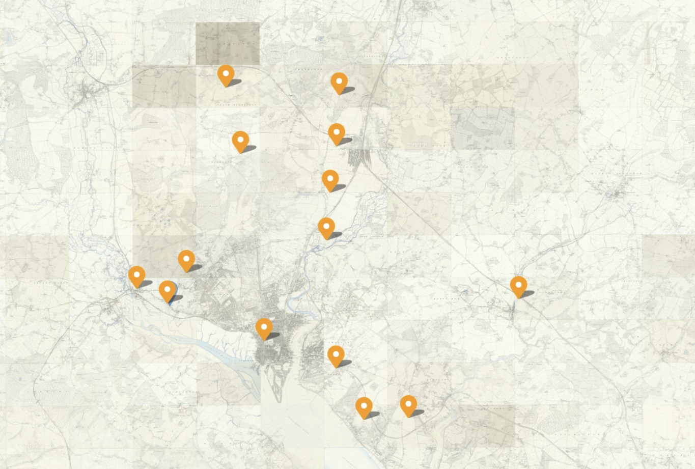 Domesday Book Places in the Hundred of Mansbridge OS 25 inch map 1892 - 1914
Now, my normal go to map, the OS 25". It does not add much. The 25" is much more suited to being zoomed in very close to the detail, sometimes to an individual property. That competes the set of old Ordnance Survey Maps from the National Library of Scotland.

A quick change of the transparency level and the underling base map is revealed. There are many to select from, and this is the Open Street Map. That is on the source map of course, these are just static screen shots.
Much easier to see comparative locations on this view. Note, North Baddesley appears to have moved somewhat. The plotted position is now referred to as Old North Baddesley.
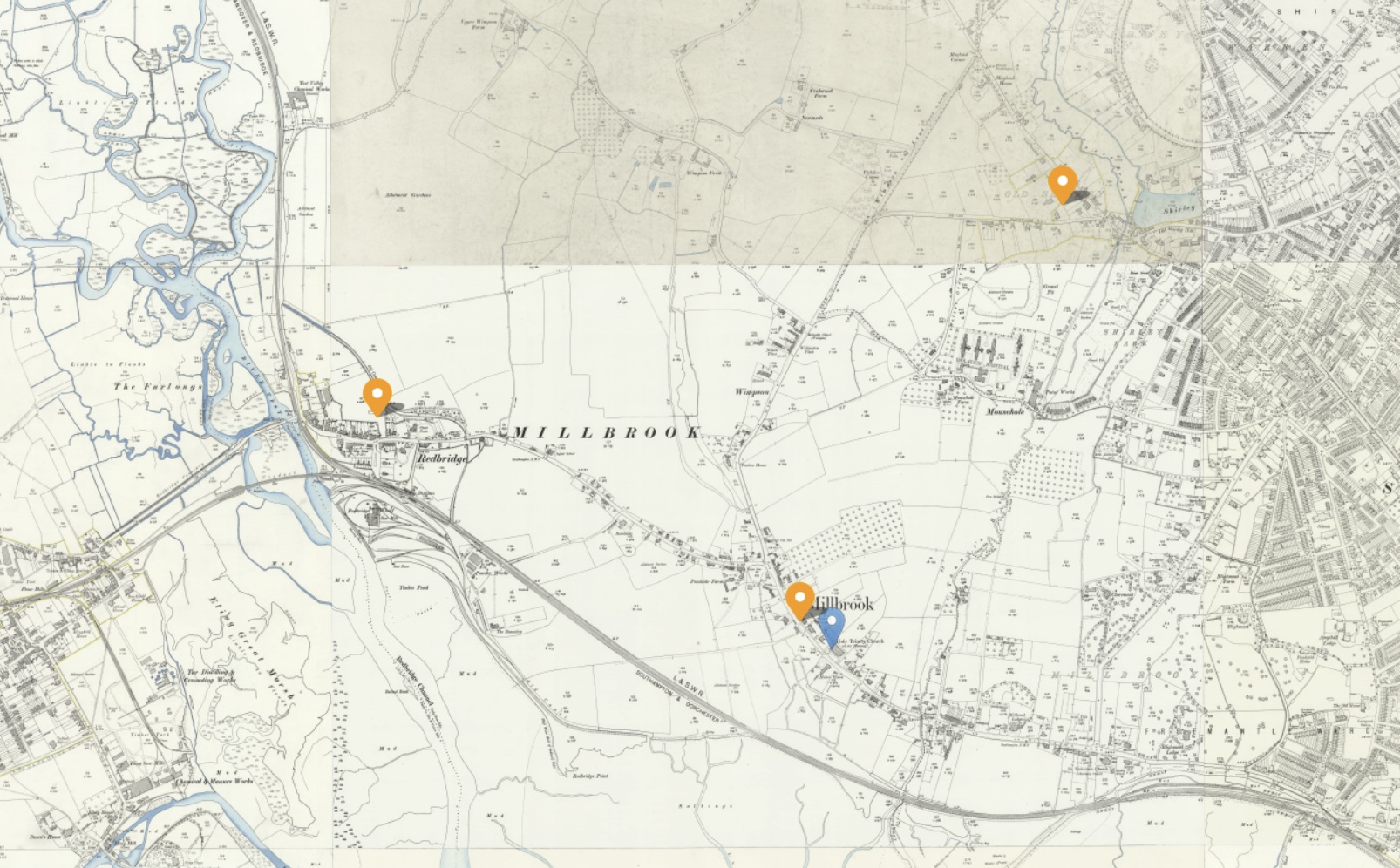 Domesday Book Places in the Hundred of Mansbridge OS 25 inch three places, Millbrook, Redbridge, and Shirley
A closer slice of the above OS 25" map for the three places of interest, Millbrook, Redbridge, and Shirley.
Hoping to add interactive ESRI map of the above, here.
xxxxxxxxxxxxxxxxxxxxxxxxxxxxxxxxxxxxxxxxxxxxxxxxxxxxxxxxxxxxxxxxxxxxxxxxxxxxxxxxxxxxxxxxxxxxxxxxxxxxxxxxxxxxxxxxxxxxxxx
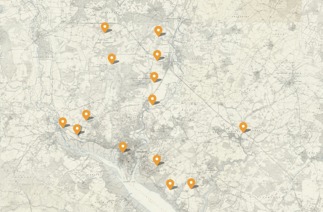
An ESRI map of 15 of the 16 places listed in the Domesday book, The Great Survey of England, as being in the Hundred of Mansbridge.
I am hoping that it appears on your view, as it does mine.
Whereas the other maps were screenshots of a map, this one is zoomable, interactive. With the icon in the top left you can change which basemap it displays. I believe that when the page is refreshed, it reverts to the initial basemap, On the right hand side there are some more icons, including one to open it in ESRI's Map Viewer, it's native environment. The markers have popups, which show the name of the place, together with the Domesday name, and a little information from the Domesday entry.
The markers for the Hundred of Mansbridge are an inverted raindrop, in black with a round spot in the top. The map is initially focused on Mansbridge.
The markers with the green dots are the ones that are the subject here, Millbrook, Redbridge, and Shirley. The marker with the red dot is Southampton, the major population centre in the Hundred of Mansbridge, at 40% of the whole.
The smallest population is 5 households in Redbridge.
The markers for the Hundred of Buddlesgate are a circle with a straight line from the bottom leading to a cross, x. It also has a round spot in the top. There are only four places in the Domesday Book in the Hundred of Buddlesgate, two of which can be seen here. Nursling is our place of interest in the Hundred of Buddlesgate, and it is coloured blue.
The markers for the Hundred of Redbridge are a circle with a straight line from the bottom. The ancient Parish of Eling is our place of interest in Hundred of Redbridge, and those markers are coloured yellow.
Hundreds of Mansbridge, Buddlesgate, and Redbridge
The map currently has the places of three Hundreds, Mansbridge, Buddlesgate, and Redbridge, extracted form the Domesday Book of the Great Survey of England, and plotted therein. The focus is on Mansbridge, with the other two included for comparison.
There were 16 places in the hundred of Mansbridge in Domesday Book. I have not been able to locate Hinton within the Hundred of Mansbridge. 15 are plotted on the above map.
There were 4 places in the hundred of Buddlesgate in Domesday Book. All 4 are plotted on the above map.
There were 24 places in the hundred of Redbridge in Domesday Book. Lestred, Achelie, Buckholt, Northam, and Nutlei have been officially declared as lost within the Hundred of Redbridge. 19 are plotted on the above map.
The combined population of Millbrook, Redbridge, and Shirley in 1086 was 45 households. For comparison, Nursling was 30, and the ancient Parish of Eling constituents were 109, of which Eling alone was 69.
xxxxxxxxxxxxxxxxxxxxxxxxxxxxxxxxxxxxxxxxxxxxxxxxxxxxxxxxxxxxxxxxxxxxxxxxxxxxxxxxxxxxxxxxxxxxxxxxxxxxxxxxxxxxxxxxxxxxxxx
Millbrook
Link to the Open Domesday Entry for Millbrook,
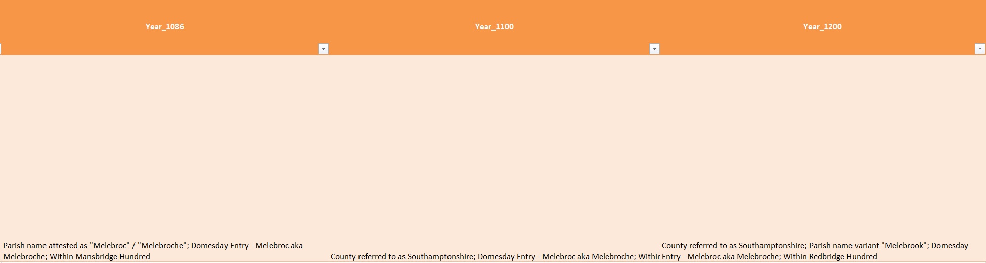
Millbrook was a settlement in Domesday Book, in the hundred of Mansbridge and the county of Hampshire.
It had a recorded population of 28 households in 1086, putting it in the largest 40% of settlements recorded in Domesday.
| Land of |
Winchester (St Peter & St Swithin), bishop of |
|
| Households | ||
| 28 villagers. | ||
| Land and resources | ||
| Ploughland: | 5 ploughlands. 5 men's plough teams. | |
| Other resources:. | Meadow 14 acres. Woodland 5 swine render. | |
| Valuation | ||
| Annual value to lord: | 5 pounds in 1086; 5 pounds when acquired by the 1086 owner; 5 pounds in 1066 | |
| Owners | ||
| Tenant-in-chief in 1086: | Winchester (St Peter & St Swithin), bishop of. | |
| Lord in 1086: | villagers. | |
| Overlord in 1066:. | Winchester (St Peter & St Swithin), bishop of. | |
| Lord in 1066: | villagers. | |
| Other information | ||
| Phillimore reference: | Hampshire 3,17 |
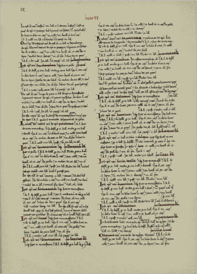
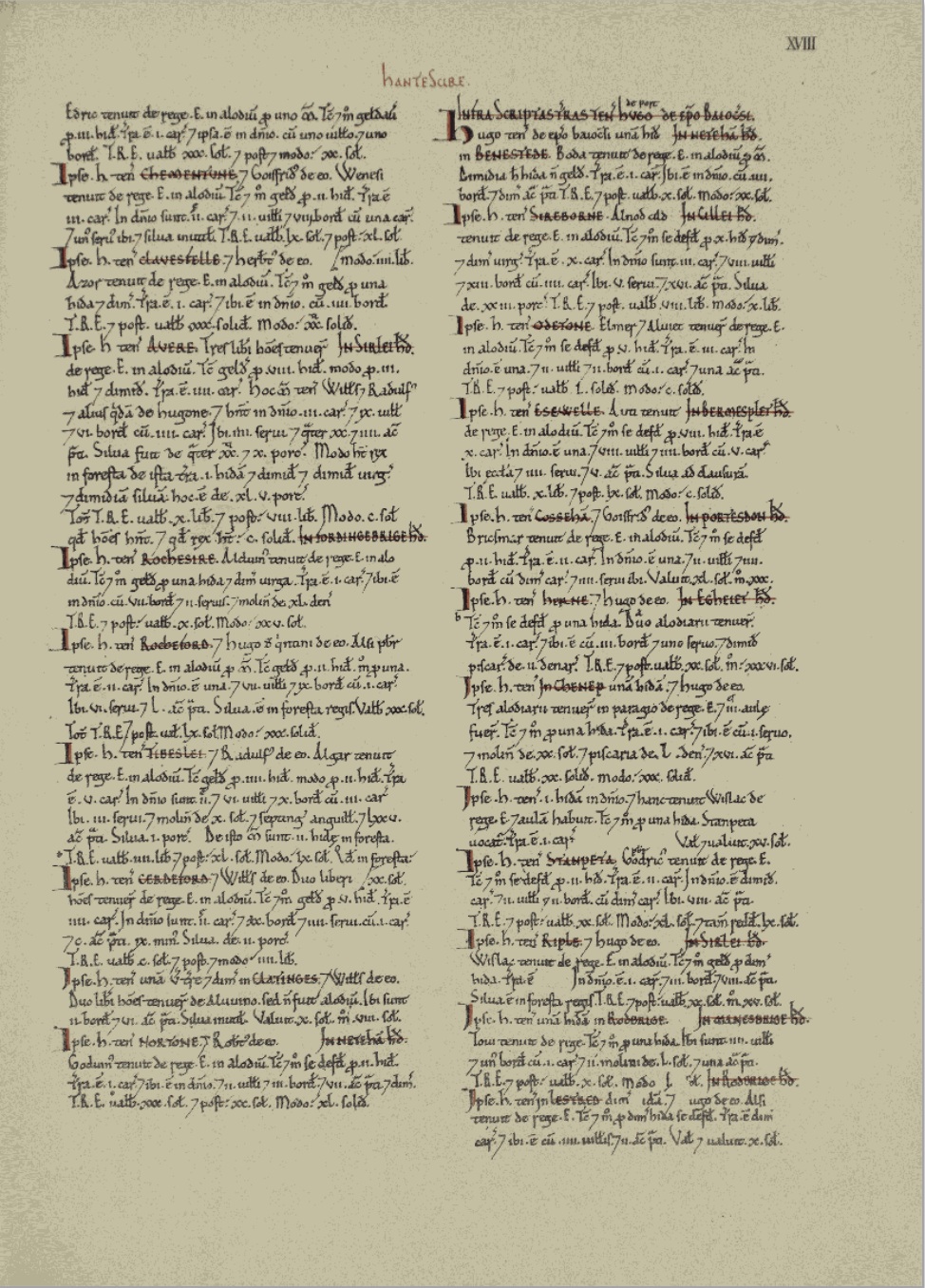
A copy of the page of the Domesday Book, 1086, with the entry for Millbrook, enlarged below.
Millbrook was called Melebroc in the Domesday book, as can be seen above.
Shirley
Link to the Open Domesday entry for Shirley
Shirley was a settlement in Domesday Book, in the hundred of Mansbridge and the county of Hampshire.
It had a recorded population of 12 households in 1086.
| Land of |
Ralph of Mortimer |
|
| Households | ||
| 4 villagers. 3 smallholders. 5 slaves.. | ||
| Land and resources | ||
| Ploughland: | 8 ploughlands. 2 men's plough teams. | |
| Other resources:. | Meadow 12 acres. Woodland 6 swine render. 1 mill, value 2 shillings and 5 pence. 1 fishery. 1 church | |
| Valuation | ||
| Annual value to lord: | 5 pounds in 1086; 5 pounds when acquired by the 1086 owner; 5 pounds in 1066. | |
| Owners | ||
| Tenant-in-chief in 1086: | Ralph of Mortimer. | |
| Lord in 1086: | Ralph of Mortimer. | |
| Overlord in 1066:. | King Edward. | |
| Lord in 1066: | Cypping (of Worthy). | |
| Other information | ||
| Phillimore reference: | Hampshire 29,5 |
A copy of the page of the Domesday Book, 1086, with the entry for Shirley, enlarged below.
Redbridge
Link to the Open Domesday entry for Redbridge
Redbridge was a settlement in Domesday Book, in the hundred of Mansbridge and the county of Hampshire.
It had a recorded population of 5 households in 1086, putting it in the smallest 20% of settlements recorded in Domesday.
| Land of |
Bishop Odo of Bayeux |
|
| Households | ||
| 4 villagers. 1 smallholder. | ||
| Land and resources | ||
| Ploughland: | 1 men's plough teams. | |
| Other resources:. | Meadow 1 acres. 2 mills, value 2 pounds 10 shillings. | |
| Valuation | ||
| Annual value to lord: | 3 pounds in 1086; 10 shillings when acquired by the 1086 owner; 10 shillings in 1066. | |
| Owners | ||
| Tenant-in-chief in 1086: | Bishop Odo of Bayeux. | |
| Lord in 1086: | Hugh of Port. | |
| Overlord in 1066:. | King Edward. | |
| Lord in 1066: | Tovi. | |
| Other information | ||
| Phillimore reference: | Hampshire 23,66 |
A copy of the page of the Domesday Book, 1086, with the entry for Redbridge, enlarged below.

The settlements of Wimpson and Hill, mentioned on some later maps, are not found in the Domesday Book.
Late Medieval - 1350 to 1539
Late Medieval - 1350 to 1539
Millbrook Church
The first record of the church of Millbrook is in 1282, when it was noted as being in the Deanery of Southampton. It belonged to the Bishop of Winchester. It's date of construction is not known.
The church became very delapidated and in 1872 the new church - Holy Trinity - was built (on a different site - SU3852 1308 IP). Thereafter the church was occasionally used until 1921 when it closed. By 1939 it had been completely demolished, and the whole churchyard cleared. A caravan park was established on the site and the tower foundations were converted into a flower bed.
Prior to being pulled down the body of the church consisted of a plain 15th century tower of three stages, while the rest was a rebuild dating to 1824.
The church is shown on the pre-WWII Hampshire map.
In 1797 an Act was secured to rebuild part of the old church.
The area of the church is now under Millbrook Road West.
Although the above ground church has been destroyed, the extent of survival of below-ground remains is unknown.
Includes a photograph of the church. See web site.
Concerning a wall monument installed in St Nicholas Church, Millbrook in the 1830's. This was a carving by the well known sculptor, Edward Hodges Baily (sculptor of Nelson on Nelson's Column). It was commissioned by Nathaniel Ogle in memory of his mother, Anna Maria Ogle (of the Ogle family of Southampton). The sculpture was described when it was exhibited at the RA in 1830, prior to its placement in the church. No image of it exists. Probably lost when the church was demolished.
Early 20th century photograph, with the church in the background. Found on a Facebook site
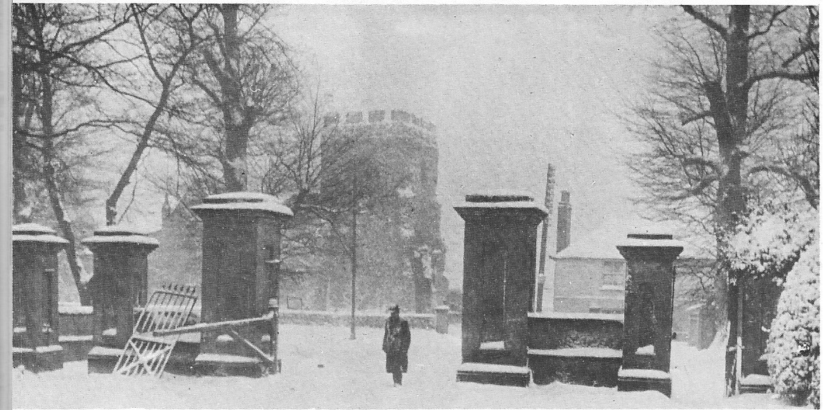
This set of gates used to be the entrance to the Regent's Park Estate. They were situated at the Millbrook Road end of Regents Park Road. The church in the background was the orginal Millbrook Church. Some of the stones for this church were brought down from the orginal village of Shirley which was situated around the area of Winchester Road/Romsey Road cross roads. Before Percy Road was built excavations took place and a grave site containing over 200 human remains and the site of an old church. That was were the Millbrook Church stones came from. I wonder if the stones were used when the present Millbrook Church was built?
Words from Rod Andrews on Facebook
Plus a comment from Eric Payne
A great picture. This must have been taken pre 1939 as I believe the church was demolished in that year. After Sat morning flicks at the Atherly, us kids very often headed for the old graveyard to play out our games of cowboys and Indians. I had a bit of a shock recently when my young grandson aged 7 asked "What's a cowboy?"
Shirley Church
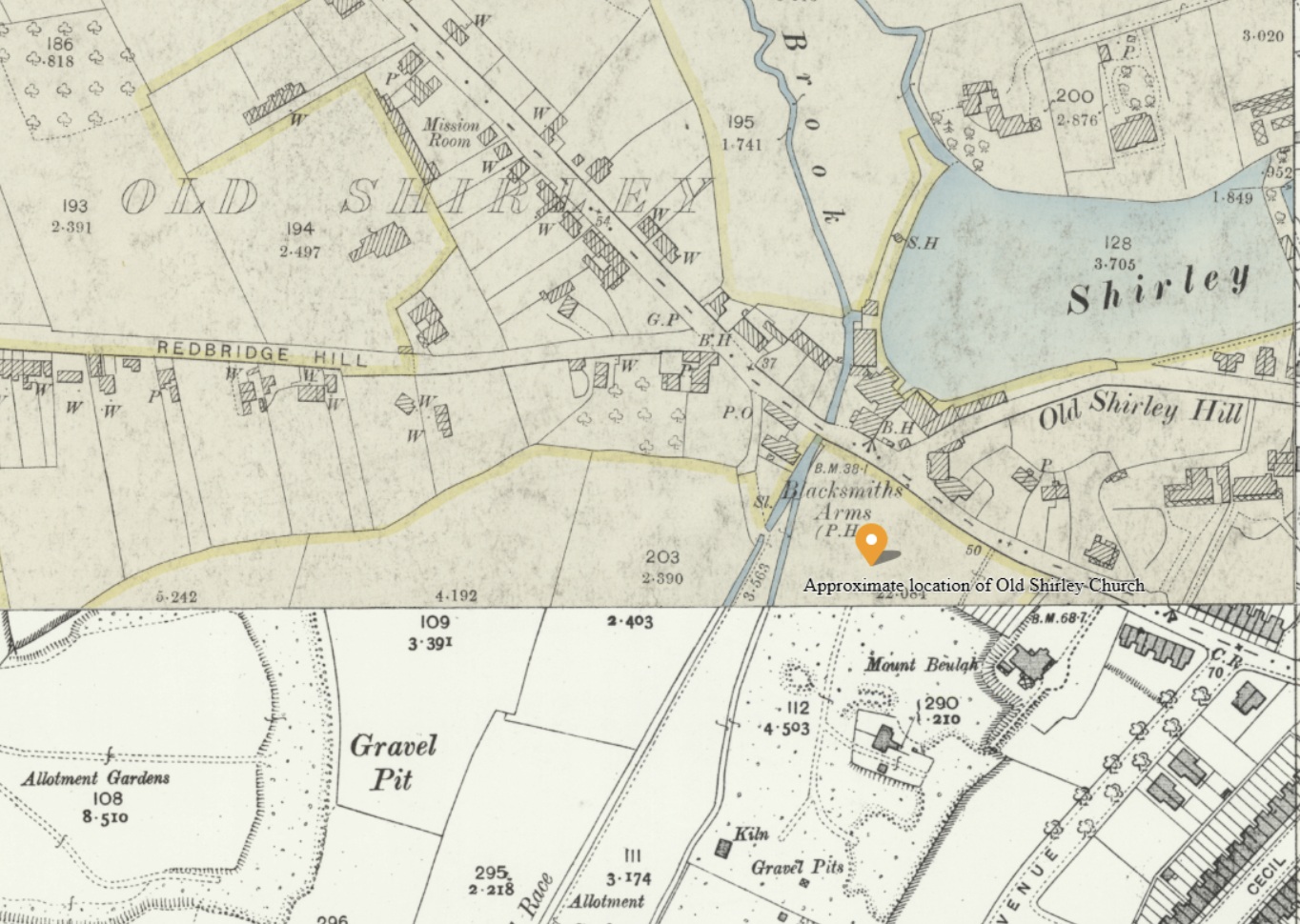
From the discussion on Facebook, this may be the location of the Old Shirley Church, which would have been demolished before 1282. It is a logical location based on the Old Shirley settlement of the map, and the streams and mill ponds.
Another Facebook entry,
Percy Road in Shirley, circa early 1900s, I think the modern day comparison location is about right. When the ground was cleared to build this housing development, a significant number of human remains were discovered. It’s believed the area was the graveyard for the original Shirley village church that was in that area.
An Heritage Gateway Entry
There was a church in Shirley at the time of the Domesday Survey (1086). In 1574, the parish church of Shirley was said to be rather small and in a state of ruin, and in that year the church and cemetery were annexed to Millbrook parish. The church was apparently pulled down in about 1609 and its materials used to enlarge Millbrook church. The location of the site of Shirley Church is uncertain as no locational details are given in the primary sources and it is not shown on any maps. Observations by Kell in the late 19th century (SOU 662) may have revealed part of the cemetery, although the location of Kell's observations is also unclear. Two locations for the church have been suggested. One location is the former Mount Beulah plot; an evaluation excavation on part of that plot in 1996 (SOU 742) failed to reveal evidence of either church or cemetery. The other location is the area now in the middle of the modern road junction of Winchester Road, Redbridge Hill, Romsey Road and Tebourba Way. Gravestones have been found on "Old Shirley Mill hill" although the location of this hill is uncertain.
[1], citing [2] and other sources: There was a church in Old Shirley at the time of the Domesday Survey (1086 IP), the advowson of which belonged to the lords of the manor of Shirley until 1233 when the advowson was granted to St Denis Priory. The church was subsequently appropriated to the Priory until the Dissolution when it fell into the King's hands. In 1549, Edward VI granted the rectory and tithes to Nich. Prideaux and the rectory and advowson thereafter occur in various hands until 1791.
[3]: In 1574 "The parish church . . . was in existence in far removed times as it now exists, rather small and in straitened circumstances." The tithe was less than £5. The church was owned by James Pagett. In 1574 the church and cemetery were annexed to Millbrook parish, reserving the rectory, glebelands and tithes to James Pagett etc. The church was in a state of ruin.
[4]: The church at Old Shirley is supposed to have been pulled down c1609 and its materials used to enlarge Millbrook church.
IP 24/3/1998: The location of the site of Shirley Church is uncertain. There are no locational details given in the primary sources and no maps show the site. Observations by Kell in the late 19th century (SOU 662) [6] may have revealed part of the cemetery; although the location of Kell's observations is also unclear they may have been located on part of the Mount Beulah plot (see related record for discussion). The OS Antiquity Card [5] locates the church on the Mount Beulah plot (grid reference SU 3937 1412). 18th and 19th century placename evidence ("Church Field" and "Church Close Litten" respectively) is linked in [5] to the Mount Beulah site. However an evaluation excavation (SOU 742) on the Mount Beulah plot failed to reveal evidence of the church or cemetery [8]. Gravestones have been found on "Old Shirley Mill hill" [4] although the location of this hill is uncertain. [7] suggests that Kell's observations, and hence the church and graveyard, were located on the level area now in the middle of the road junction of Romsey Road, Winchester Road, that is at approximately grid reference SU 3931 1423, although the case is not argued through. (See related records for details of all the above.)
HER 6/6/13: [9][10] are 20th century references, clearly to the find described in [6], although not giving source. [10] gives the date of the find as 1850.
Early Modern - 1540 to 1699
Early Modern - 1540 to 1699
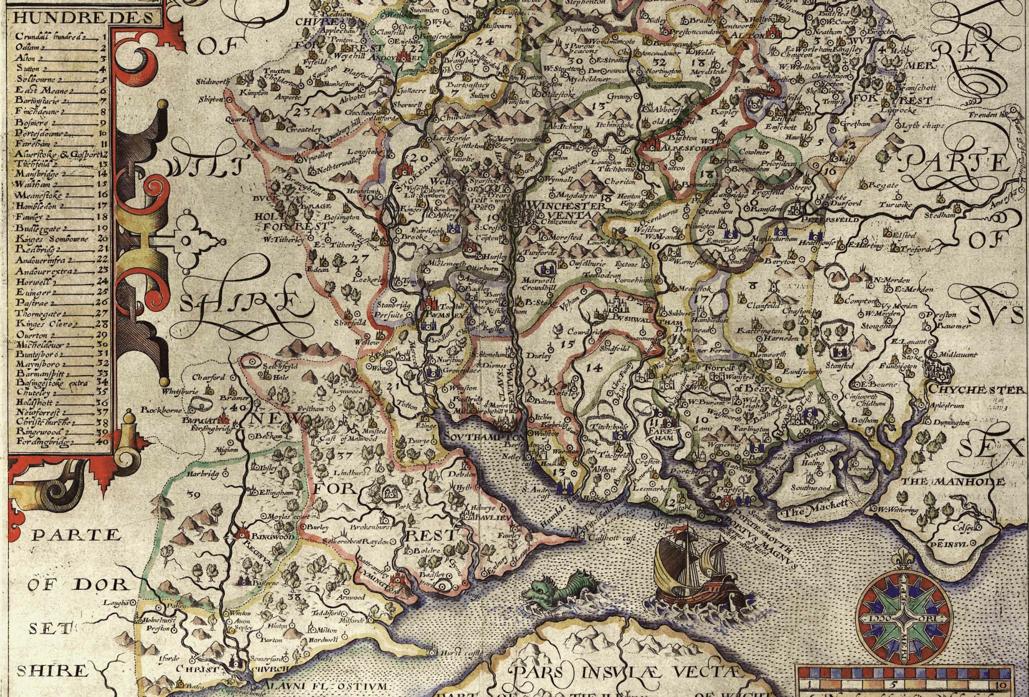
Norden's Map of Hampshire, 1607, extract of. Particluar interest it the Hundreds. In the Doomesday Book Millbrook, Shirley, and Redbridge, were all in the Hundred of Mansbridge (14). However, on the above Norden's Map of Hampshire, 1607, they were in the Hundred of Redbridge (21), and in respect of Millbrook in Waltham (15). From the key for Hundreds, there were a total of 40 named Hundreds. The settlements of Wimpson, Redbridge, Millbrook, and Hill, are shown on the map, but there is an absence of Shirley.
Slightly earlier, but included here for comparison.
Extract of Norden's Map of Hampshire, 1595, Slightly earlier but similar with respect to Hundreds.
The same map but zoomed in. The boundary for the Hundred of Redbridge is marked in red. Not by me on this occasion.
The settlements of Wimpson, Redbridge, Millbrook, and Hill, are shown on the map, but there is an absence of Shirley.
Modern - 1700 to 1840
Modern - 1700 to 1840
Victorian - 1841 to 1901
Victorian - 1841 to 1901
Modern Administrative - 1902 to ongoing
Modern Administrative - 1902 to ongoing
Beginning of WWII 1939 to Absorption into Southampton 1952
Beginning of WWII 1939 to Absorption into Southampton 1952
.
The Records Section.
The next few sections are all about the available records, which don't necessarily fit to a timeline because of the time spread of the records, particularly the Census.
Tithe Apportionment and Map
Tithe Apportionment and Map

Tithe Apportionment - Parish of Millbrook, Hampshire
Note the reference to Depopulation and read more about it here. By 1530 the population of England and Wales had risen to around 3 million. At the end of the 17th century it was estimated the population of England and Wales was about 5 1/2 million. The population of Scotland was about 1 million. The population of London was about 600,000. London went on to become the biggest city in the world for a while. In the 19th century Britain became the world's first industrial society. It also became the first urban society. By 1851 more than half the population lived in towns. As our population approaches 70m it is interesting to think of depopulation efforts at 3 million! The maps of Millbrook clearly show the urbanisation of the countryside.
Following the Tithe Commutation Act 1836 Tithe Maps were produced which recorded both the Landowner and Occupier for most lands. From the Tithe Apportionments records it is apparent that on 4th March 1843 Lady Hewitt was both the Landowner and Occupier of Plot 875, Freemantle Estate, described as House Offices and Pleasure Grounds, with an area in statute measure 6,0,2, about 2.4 Hectares.
Nathaniel Newman Jefferys was both Landowner and Occupier of Plot 825 described as House Offices and Garden, an area of 2,2,24 imperial, on 4th March 1843. However, one plot does not show the full picture.
Using the Tithe Apportionment map of the Parish of Millbrook, Hampshire, as a base, I have colour washed some of the plot landowners. The Freemantle and Banister Estates, pale orange and brown respectively can be clearly seen. The landowners in 1843 where Lady Hewitt and Reverend William Fitzhugh. Shirley Park, owned by William Henry Roe, is in green. Blightmont Lodge, occupied by Lady Lisle, just north of Millbrook Road, and part of the larger Berrywood estate owned by Nathaniel Newman Jefferys is shown in a slightly darker blue than the light blue of the rest of the estate. It appears that Nathaniel Newman Jefferys has bought a large swath of the newly released Shirley Common land in the area of Shirley Warren. Clement Hoare & William Dunn seem to have also taken advantage of the inclosue of Shirley and Nutshalling Commons, as joint owners of plots coloured lime green. Roads such as Warren Avenue, Warren Crescent and Tremona Road have already been laid out for the impending urbanisation. However, the biggest landholding in the Parish, by a long way, is Sir John Barker Mill and various associates who together are landowners of the pink coloured plots, mainly farmland in 1843, but destined to be developed and absorbed as suburbs of Southampton.
Introduction and Conclusion
Introduction and Conclusion
Greenwood's Hampshire 1826 section 53
Moving into the current, the Church of England has a database of interesting statistics about all the Parishes in the country. Below is the Map which covers the original Millbrook Parish and shows the current Parishes of;
Millbrook: Holy Trinity
Freemantle: Christ Church (1851)
Shirley: St James (1836)
Maybush.
Click on the parish to bring up the statistics.
The Parish of Millbrook Tithe Map 1843 including Shirley, Freemantle and Four Posts, layered onto Google Earth Pro and Geolocated. Same base map as the coloured ownership map. Over 20 separate tiles or files to fit spherical base globe of Google Earth. All adjusted to best fit the projection, and align roads and as many details as possible. Below is just an image of the result. Google Earth Pro is desktop based so does not lend itself to sharing. However, using transparency of the layers I can locate buildings on the tithe map and see what is there now. I can also use the Lat and Lon and show on Google Maps to georeferenced individual buildings or plots.
The interactive version is created using a Project in Google Earth and can be seen here, The Parish of Millbrook Tithe Apportionment. Using the Tithe Map plotted on Google Earth Pro above and other maps, I have placed some of the Property names onto a Google Earth Project with an up to date backdrop. History mapped to now.
A screenshot as at March 2020. Work ongoing.
Notes
Notes
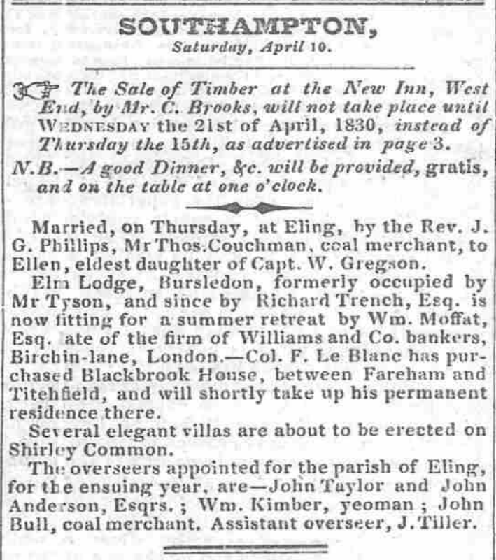
Extract from the British Newspaper Archive. Link to source but subscription required.
SOUTHAMPTON, Saturday, April 10. The Sale of Timber the New Inn, West JSr.d, by Air. C. Brooks, will not take place until Wednesday the 21st of April, 1830, instead of Thursday the 15th, as advertised in page 3. j N.B. good Dinner, Sfc. will be provided, gratis, and on the table at one o'clock. Married, on Thursday, at Eling, by tbe Rev. J. G. Phillips, MrThos.Couchman, coal merchant, to Ellen, eldest daughter of Capt. W. Gregson. Elm Lodge, Bursledon, formerly occupied by Mr Tyson, and since by Richard Trench, Esq. now fitting for a summer retreat by Wm. Moffat, Esq. ate of the firm of Williams and Co. bankers, Birchin-lane, London.—Col. F. Le Blanc has purchased Blackbrook House, between Fareham and Titehfield, and will shortly take up his permanent residence there. Several elegant villas are about to be erected on Shirley Common. Tht: overseers appointed for the parish of Eling, for tbe ensuing year, are—Jolin Taylor and John Anderson, Esqrs. Wm. Kimber, yeoman John Bull, coal merchant. Assistant overseer, J.Tiller.
Several elegant villas are about to be erected on Shirley Common.
Thought to be Plots 760 to 776 as shown on the Tithe Apportionment Map, in the Tithing of Hill and Sidford. Built on the Romsey Turnpike, later to become Shirley Road, the A3057. In the vicinity of the Rising Sun Public House, probably of the same date.
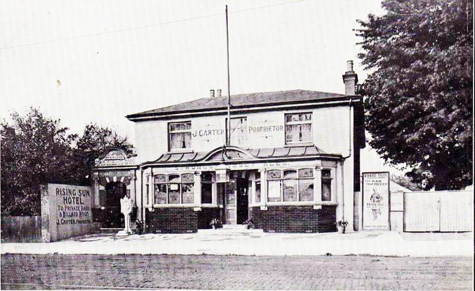
The Rising Sun public house in Shirley Road, now renamed The Brass Monkey. It opened in 1830, it's postal address was Shirley Common and it was a quiet country wayside inn. In this photo, it is called 'Rising Sun Hotel', J. Carter is the proprietor and Strong's of Romsey is the Brewery.
Transcription
Transcription
The Agreement is first transcribed into the Excel spreadsheet as part of the process of collating the data.
| APPORTIONMENT of the RENT-CHARGE in lieu of TITHES in the | Parish | of | Millbrook |
| in the | County | of | Southampton |
| Whereas an Agreement for COMMUTATION of TITHES in the | Parish | of | Millbrook |
| in the | County | of | Southampton |
| was, on the fourth Day of March in the Year One Thousand Eight Hundred and Forty three, | 4th March 1843 | ||
| confirmed by the Tithe Commissioners for England and Wales, of which Agreement, with the Schedules thereunto annexed, the following is a Copy :-- |
|
Articles of Agreement
|
| for the Commutation of the Tithes of the Parish of Millbrook in the County of Southampton in pursuance of the Act for the Commutation of Tithes in England and Wales made executed at a Meeting duly called and holden in the said Parish and adjourned from time to time and holden by Adjournment on the thirty first day of May in the year of our Lord One thousand eight hundred and forty two By and Between the Several Persons Owners of Land within the said Parish by whom or by whose Agents |
| duly authorised in that behalf these presents are executed and the interest of which Land Owners in the said Parish is not less than two thirds of the Lands therein subject to Tithes of the one part |
| The Reverend William Joseph George Phillips |
| who as Rector of the said Parish of the said Parish is Owner of a portion of the Tithes as well Great as Small thereof arising from forty six acres two roods and one perch of Titheable Lands which are setforth in the Second Schedule hereunder written and are |
| situate and being in the Tithing of Hill and Sidford in the said parish and |
| Sir Charles Henry Rich |
| now of Francfort on Maine Baronet Owner of another portion of the Tithes consisting of all the Tithes as well Great as Small arising from all the titheable lands in the said Tithing of Hill and Sidford excepting only all the Tithes of the before mentioned forty six acres two roods and one perch of land and also excepting all the Tithes as well as Great as Small arising from the Tithable lands of the said Tyithing of Hill and Sidford which are setforth in |
| the third fourth fitth and sixth Schedules hereunder written and are therein particularly described and |
| Sir John Barker Mill |
| of Mottisfont Abbey in the said County of Southampton Baronet Owner of the remaining portion of the Tithes as well great as small of the said parish consisting of all the Tithes arising from the titheable lands of the said Tything of Hill and Sidford which are setforth in the third fourth fifth and sixth Schedules hereunder written and are therein particularly described of the other part |
| Whereas |
| the said |
| Sir John Barker Mill |
| is seized in possession of an Estate for life with remainder to his Children in tail of all the Tithes of the lands ??? ??? particularly specified and described in the said third schedule hereunder written and is also seized in possession of an Estate for life with remainder to his children in tail of and in the said lands |
| Now |
| he the said |
| Sir John Barker Mill |
| Doth hereby declare it to his Will and Intent certified by his signature and seal hereunder annexed that the said Tithes as well great as small of the said lands shall henceforth be absolutely merged and extinguished in the freehold and inheritance of the said Lands. |
| It is |
| hereby agreed that the sum of Five hundred and fifty pounds by way of Rent Charge subject to the provisions of the said Acts shall be paid to the said |
| William Joseph George Phillips as Rector |
| of the said Parish and to his Successors instead of all the tithes as well great as small and all moduses and compositions real and prescriptive and customary payments payable to the said Rector in respect of the tithable lands of the said Parish or the produce thereof (except the customary payment of the sum of Five pounds hereinafter mentioned) and also including the tithe of Glebe the rent charge in lieu of which it is hereby agreed shall be fixed at the sum of six shillings in respect of all the tithes as well great as small of all the glebe lands of the said Parish which Glebe land belongs to the said |
| William Joseph George Phillips |
| and consists of three roods and thirty three perches and which item it is hereby agreed shall be apportioned exclusively upon the said Glede lands |
| And it is |
| hereby further agreed that the annual sum of Two hundred and fifty six pounds ten shillings by way of rent charge subject as afordsaid and also charged with the payment thereout of the entire provision or stipend amounting to the sum of Four pounds annually to the Rector of the said Parish for the time being which sum hash been customarily paid by the Lay Impropriator of the tithes of the Tythings of Hill and Sidfoord in the said Parish shall be paid to the said |
| Sir Charles Henry Rich |
| and his assigns during his life and after his decease to the person or persons who for the time being shall be entitled to the same instead of all those tithes of which the said |
| Sir Charles Henry Rich |
| is Owner as aforesaid and all Moduses and Compositions real and prescriptive and customary payments payable to him in respect of any of the titheable lands of the said Parish or the produce thereof |
| And it is |
| hereby further agreed that the annual sum of Thirteen pounds seven shillings and six pence by way of rent charge subject to the provisions of the said Act shall be paid to the said |
| Sir John Barker Mill |
| and his assigns during his life and after his decease to the person or persons who for the time being shall be entitled to the same instead of all those tithes as well great as small and all moduses and compositions real and prescriptive and customary payments payable to him or them in respect of the titheable lands of the said Parish or the produce thereof which lands are respectively set forth and particularly described in the said fourth fith and sixth schedules to those Presents |
| And it is |
| hereby lastly agreed that the lands of the said Parish shall be discharged from the payment of tithes as well great as small except as is excepted by the said Act from the first day of October which shall happen next before the Confirmation of the Apportionment of the said rent charges and that the first payment of such rent charges shall be made or be recoverable on the expiration of Six calendar months from the time from which the said lands are discharged from the payment of tithes |
| In testimony |
| whereof the said parties to these Presents or their respective Agents thereunto duly authorized in their names and on their behalf have to these Presents subscribed and set their respective hands and seals. |
| The |
| whole Parish of Millbrook aforesaid contains two thousand nine hundred and forty seven acres two roods and eighteen perches of land statute measure |
| The |
| whole of which lands except those lands the tithes arising from which are hereinafter declared be excepted are subject to the payment of tithe |
| The |
| whole quantity of land within the said Parish which is at present cultivated as arable land is One thousand five hundred and fifty seven acres and twenty six perches Statute Measure |
| The |
| whole quantity of land within the said Parish which is at present cultivated as meadow or pasture land is Six hundred and thirty acres two roods and thirty eight perches statute measure |
| The |
| whole quantity of land within the said Parish at present forming the sites of houses and roads and consisting of homesteads wood lands and commons or wastes is Four hundred and eight acres three roods and thirty three perches statute measure |
| The |
| under mentioned lands of the said Parish set forth in the first schedule to these Presents are exempt form the payment of all tithes as well Great as Small discharged therefrom by presumption of law |
Dataset
The Dataset
The dataset comprises all of the transcribed information from the Tithe Apportionment and Maps together with additional information, including, inter alia, geolocation and census data. All held in an Excel Spreadsheet. The data is both analysed within the spreadsheet and formed into reports for export as csv files to populate the StoryMap data.
Primary Data
Primary Data
Pending population
Detailed Data - Summary
Detailed Data - Summary
Pending population
Detailed Data - Landowner and Occupier Summary
Detailed Data - Landowner and Occupier Summary
Pending population
Detailed Data - Schedule
Detailed Data - Schedule
Pending population
Land Usage
Graph of Land Usage in Whiteparish in 1842 from the Tithe Apportionment information.
Analysis of the land usage based on the Tithe Apportionment information, showing the primary use as arable at 61%, and secondary usages of woodland 18% and pasture 16%. Common and Furze land has been reduced to about 1%, presumably as a result of the Inclosure Acts, (Enclosure).
Land Ownership
Graph of Land Ownership in Whiteparish in 1842 from the Tithe Apportionment information.
Land Ownership is more widely distributed than in some parishes that I have looked at.
Scroll right to see the list of landowners associated to the graph.
Plot register
The Table with all the data of the Detailed Plot register.
This table has the Landowners and Occupiers of all the Plots in the Parish, including the Description or Names of the plots together with the State of Cultivation. It instances where there is no entry, but it is evident what the Land Usage is I have added the category surrounded with { Brace Brackets }. Not relative to the Tithe Apportionment as some of the Land Usage is not part of the charge regime, however {Residence), {Premises} and {Retail} etc are useful additions. There are approximately 220 Mansions, Houses, or Cottages etc, across the Parish.
The areas of each plot together with the Rentcharge amount in respect of both the Small and Great Tithe, for the Vicar and Impropriator.
Top Ten Landowners
Top Ten Landowners in Whiteparish from the Tithe Apportionment information
From this analysis of the plot level detail for the Parish of Whiteparish the Top Ten Landowners own 91% of the whole recorded area of the parish. Two of the Landowners were relations to the Nelson of The Battle of Trafalgar fame.
Horatio Nelson, 3rd Earl Nelson, (7 August 1823 – 25 February 1913), was 16 years 9 months 7 days at the recorded data of the survey, 14th May 1840, a Minor, hence the Guardians of ...
He was the son of Thomas Bolton (a nephew of Vice Admiral The 1st Viscount Nelson) by his wife Frances Elizabeth Eyre. On 28 February 1835 his father inherited the title Earl Nelson from William Nelson, 1st Earl Nelson and adopted the surname of Nelson. He died on 1 November that year, and his son Horatio succeeded to the title and the estate, Trafalgar House in Wiltshire, in the nearby parish of Downton. The Eyre Family were the owners of Brickworth Park according to the Turnpike Acts for the Whiteparish Romsey Southampton Road. The Dowager Countess Frances Elizabeth Nelson was recorded as being the Landowner as Brickworth Park.
The remainder are either titled or referred to as Esquire. Although not all of the Esquires are in the top ten.
Spare
Spare
Pending population
Spare
Spare
Pending population
more later
Census
Your text...
1939 Register
Your text...
Other
People
People
People of note in the parish of Nursling, through time.
Your text...
Relatives
Relatives
Some of my relatives with an association to the parish of Millbrook.
Your text...
Spare
Your text...
more later