Biddlecombe families of the Parish of Bramshaw, Part in Hampshire and Part in Wiltshire
Including the part of the parish that changed counties in the 1895 boundary change, all in or adjacent to the New Forest
The parish of Bramshaw, in the County of Hampshire, which was sometimes known as Southampton and in the County of Wiltshire
This is part of a series of articles about the Families of Biddlecombe and variations of that name. The introduction to the series is Families of Biddlecombe and variations of that name - START. If you have not visited the introduction yet might I suggest that you do so.
This is a continuation of Christopher Biddlecomb of Ringwood which started out as an article about his Last Will and Testament but quickly grew into something bigger, including families from other parts of Hampshire and into Dorset, which then spread to include Wiltshire.
The ESRI Story Map is repeated in Locations as is its introduction, but otherwise I will try to avoid duplication, referring you back to the first part instead.
Locations
Locations
The location of an event has a significant importance when looking at the past through the lens of a Family Tree. A wide family with the same surname can have many individuals with the same name and approximately the same birth year, particularly with Christian names either generally popular or past down for generations through the family. Each with their own family, and, to confuse things further, frequently with the same names for parents through the generations. Sometimes it is only the location that can separate one John from another.
This section explores some of those locations to help keep the history correct, and to share my exploration and findings.
ESRI Story Map
ESRI Story Map
Below is, in part the culmination of my 'perambulation of the borders' of the Canford Manor, plotted on a single map so as to see the true extent of the huge manor. It is a stand alone ESRI Story Map so there will inevitably be repetition.
You can also open the ESRI Story Map An exploration of Biddlecomb(e) families by clicking on the link, which will open a new page.
Planned future additions to the story are the locations of all of the people mentioned in this article for whom I can establish a location. Some are already plotted. Others include Biddlecomb(e)'s with later stories and records. All being slowly expanded.
Scroll down the insert to see the map, which can also be expanded.
Bramshaw
Bramshaw
Bramshaw, Hampshire and Wiltshire.
The name Bramshaw means Bramble Wood.
Bramshaw is interesting as a location, as the village is mainly in Hampshire and East Bramshaw is an area mainly in Wiltshire, at the date of the below map. The below map was revised in 1893, and the County Boundary was subsequently amended by Parliament in 1895.
Bramshaw village is just inside the New Forest.
Read more about the Parish of Bramshaw in British History Online A History of the County of Hampshire: Volume 3. Originally published by Victoria County History, London, 1908.
'Parishes: Bramdean', in A History of the County of Hampshire: Volume 3, ed. William Page (London, 1908), British History Online https://www.british-history.ac.uk/vch/hants/vol3/pp45-50 [accessed 6 June 2025].
VCH Victoria History of the Counties of England
Parish of Bramshaw
Current Parishes on ESRI COE Parishes Map
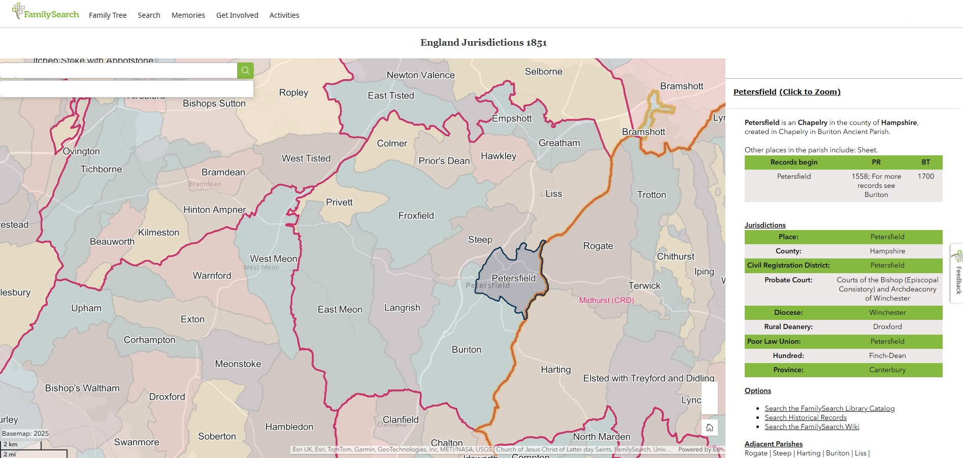
England Jurisdictions 1851 - Bramshaw
Extract from FamilySearch England Jurisdictions 1851. This link may not work if you don't have a subscription to FamilySearch
Then search for Bramshaw, Wiltshire. Use the Key to select which boundaries you wish to see.
Bramshaw, Wiltshire
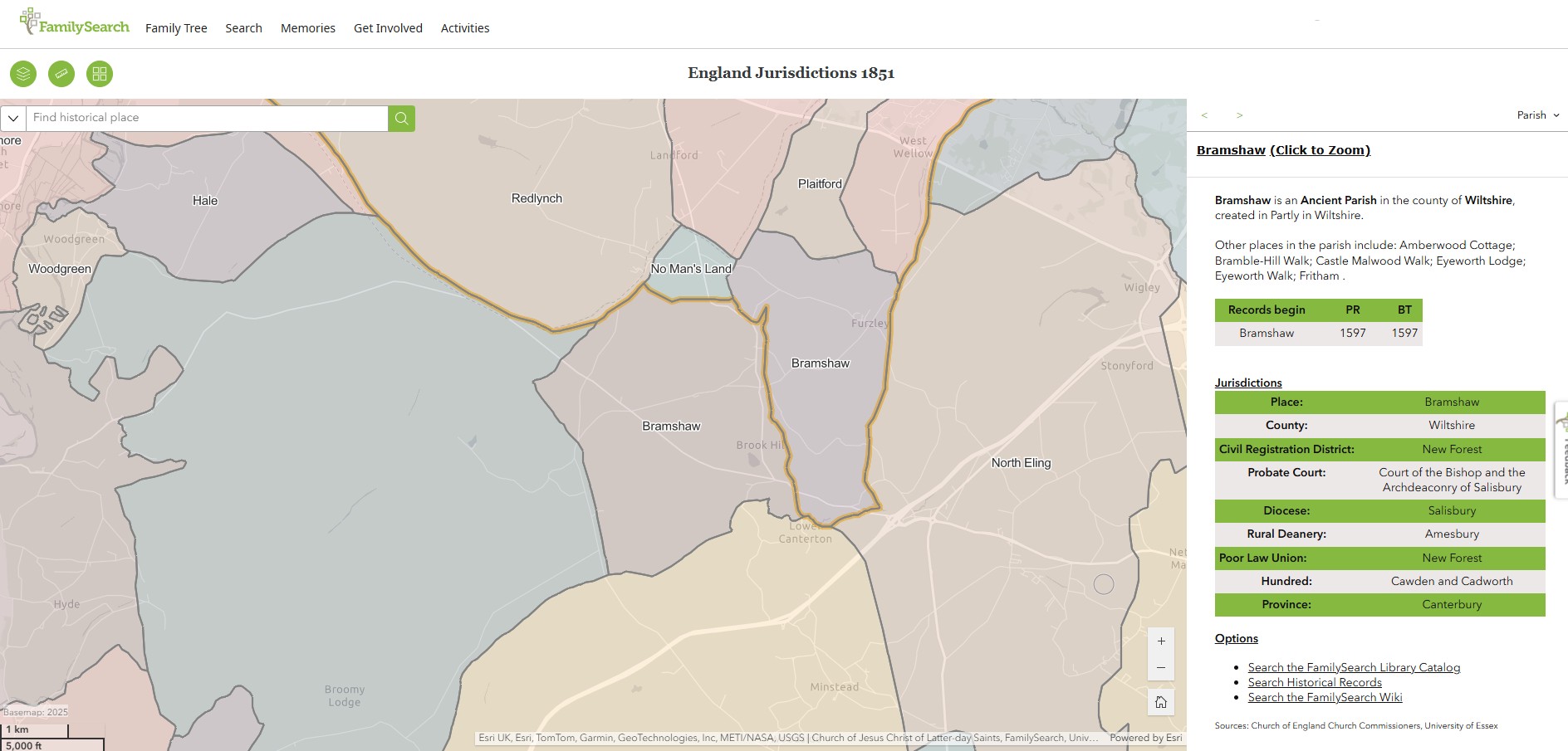
Bramshaw, Hampshire
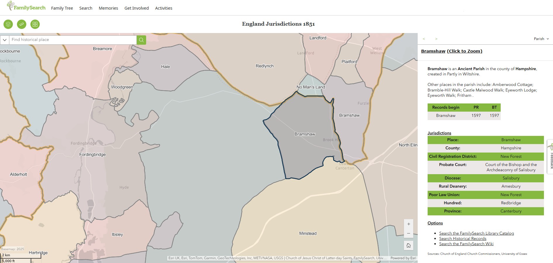
Bramshaw, just the map

Boundary Change
Act of Parliament, Boundary Change
Local Government Board's Provisional Orders Confirmation (No. 12) Act 1895
58 & 59 Vict. c. xci
6 July 1895
An Act to confirm certain Provisional Orders of the Local Government Board relating to the counties of Berks Carnarvon Derby Dorset the Parts of Lindsey Merioneth Nottingham Somerset Southampton Wilts and the West Riding of Yorkshire.
County of Southampton (Bramshaw, &c.) Order 1895.

I did expect to find the full act at legislation.gov.uk but did not. Hence the extract above.
Local Act, 58 and; 59 Victoria I, c. xci is also not available online at archives.parliament.uk not at the National Archives.
Ordinance Survey Maps
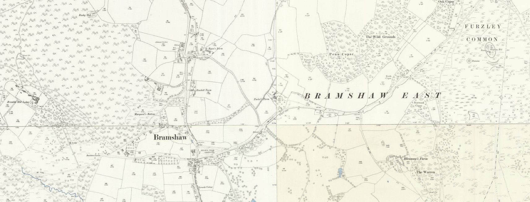
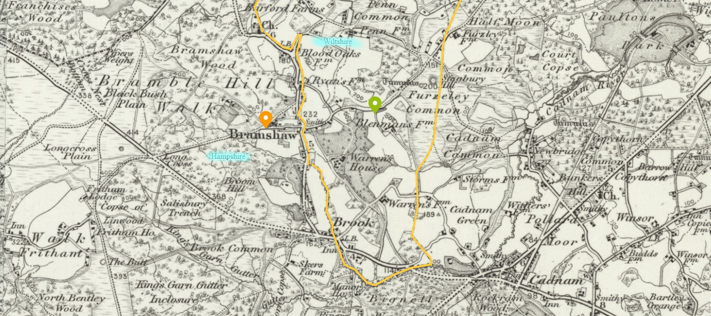 NLS OS 1 Old Map Bramshaw - Sheet 315 - Southampton Surveyed: 1866 to 1876, Revised: 1893, Published: 1895
Bramshaw village (most of) with the orange marker, in Hampshire, and East Bramshaw with the green marker, in Wiltshire. The boundary of the county of Wiltshire as shown on the map at the time, is highlighted in yellow.
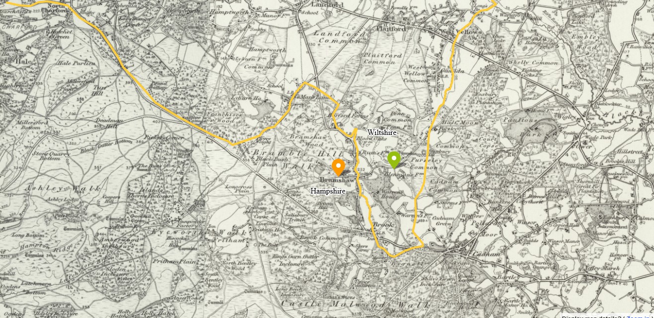 NLS OS 1 Old Map Bramshaw - Sheet 315 - Southampton Surveyed: 1866 to 1876, Revised: 1893, Published: 1895
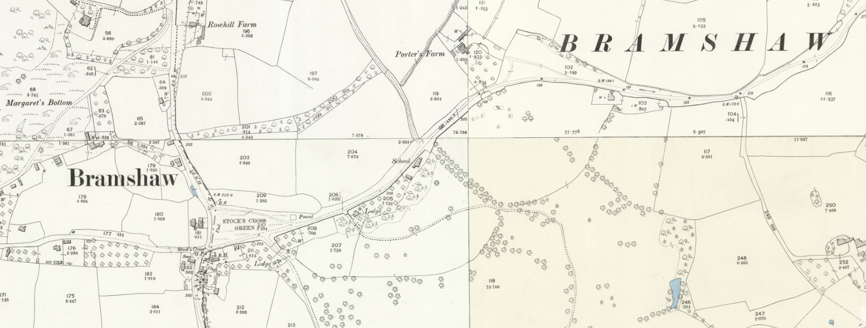
Same as above but zoomed out slightly more to show more of the boundary of the county of Wiltshire with the county of Hampshire.
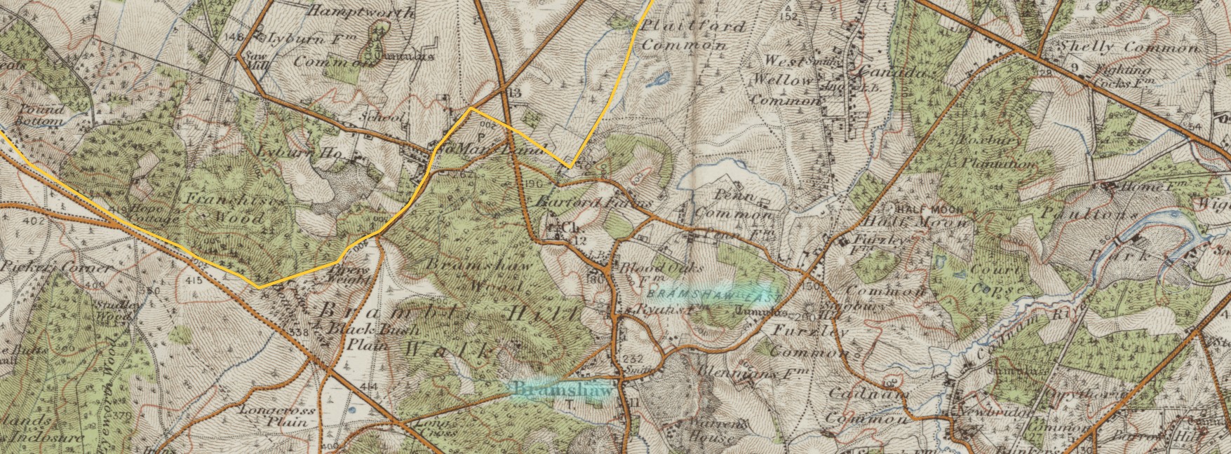 NLS - OS One Inch 3rd Ed Col Bramshaw - Sheet 134 - Ringwood Revised: 1901 to 1903, Published: 1909
Part of the county boundary revised resulting in Bramshaw and Bramshaw East being entirely in the County of Hampshire.
Ordinance Survey Maps
Changing maps to the OS 25 inch for more detail.
Three views of the same map, each zoomed in slightly further.
 NLS OS 25 Old Map Bramshaw Hampshire - Wiltshire LXXVII.16 Revised: 1900, Published: 1901 -- and -- Hampshire and Isle of Wight LVI.13 Revised: 1908, Published: 1909 -- and -- Hampshire and Isle of Wight LXIII.4 Revised: 1895, Published: 1897 -- and -- Hampshire and Isle of Wight LXIV.1
Revised: 1895, Published: 1897
Bramshaw, the village, and Bramshaw East, both in Hampshire as recorded on this map.
 NLS OS 25 Old Map Bramshaw Hampshire 2 - Wiltshire LXXVII.16 Revised: 1900, Published: 1901 -- and -- Hampshire and Isle of Wight LVI.13 Revised: 1908, Published: 1909 -- and -- Hampshire and Isle of Wight LXIII.4 Revised: 1895, Published: 1897 -- and -- Hampshire and Isle of Wight LXIV.1
Revised: 1895, Published: 1897
Zoomed in again, more detail of Bramshaw village.
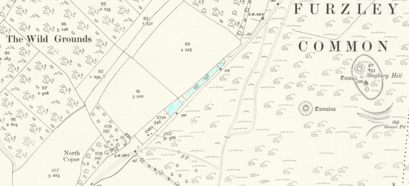
 NLS OS 25 Old Map Bramshaw Hampshire 3 Porters Farm - Wiltshire LXXVII.16 Revised: 1900, Published: 1901 -- and -- Hampshire and Isle of Wight LVI.13 Revised: 1908, Published: 1909
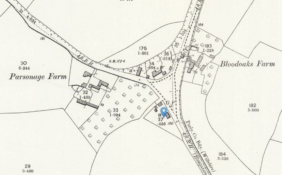
Zoomed in further still, to clearly show Porter's Farm.
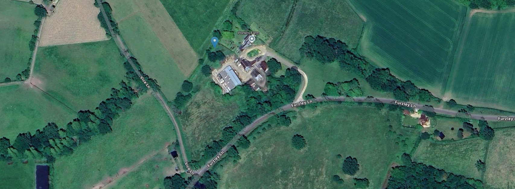
Same NLS mapping as above but with the GeoReferencing background set to Google Satellite Hybrid. Porter's Farm on Furzley Lane, or on some maps, Furzley Common Lane.
Turnpike
Act of Parliament, Turnpike
British History Online
House of Lords Journal Volume 64: 15 May 1832
Journal of the House of Lords: Volume 64, 1831-1832. Originally published by His Majesty's Stationery Office, London.
Shaftesbury Road Bill.
A Message was brought from the House of Commons, by Mr. Ponsonby and others;
With a Bill, intituled, "An Act for making a Turnpike Road from the Parish of Cann Saint Rumbold, near Shaftesbury, in the County of Dorset, through Cranborne Chase and the New Forest, to the Bell Inn at Brook, in the Parish of Bramshaw, in the County of Southampton; together with Two Branches therefrom;" to which they desire the Concurrence of this House.
Read more about this turnpike, with it's alternative name Cranborne Chase and New Forest Turnpike Trust - Shaftesbury, Dorset to Bramshaw, Hampshire
Also, read about turnpikes in general.
Tithe Apportionment
Tithe Apportionment and Maps
The Tithe records have an original date recorded as 16th May 1839. 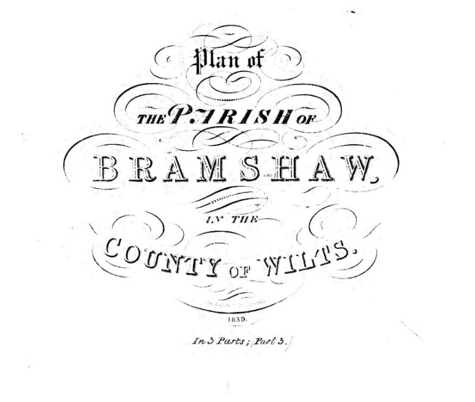
The map title, adjacent, is dated, in very small hand, as 1839.
The Tithe information I refer to here is from The Genealogist, with much thanks.
There is a further complication regarding Tithe records for the Parish of Bramshaw, in that as far as I know, the New Forest was exempt from the Tithe Apportionment and therefore no such surveys were undertaken. Only part of the Parish has Tithe Apportionment records.
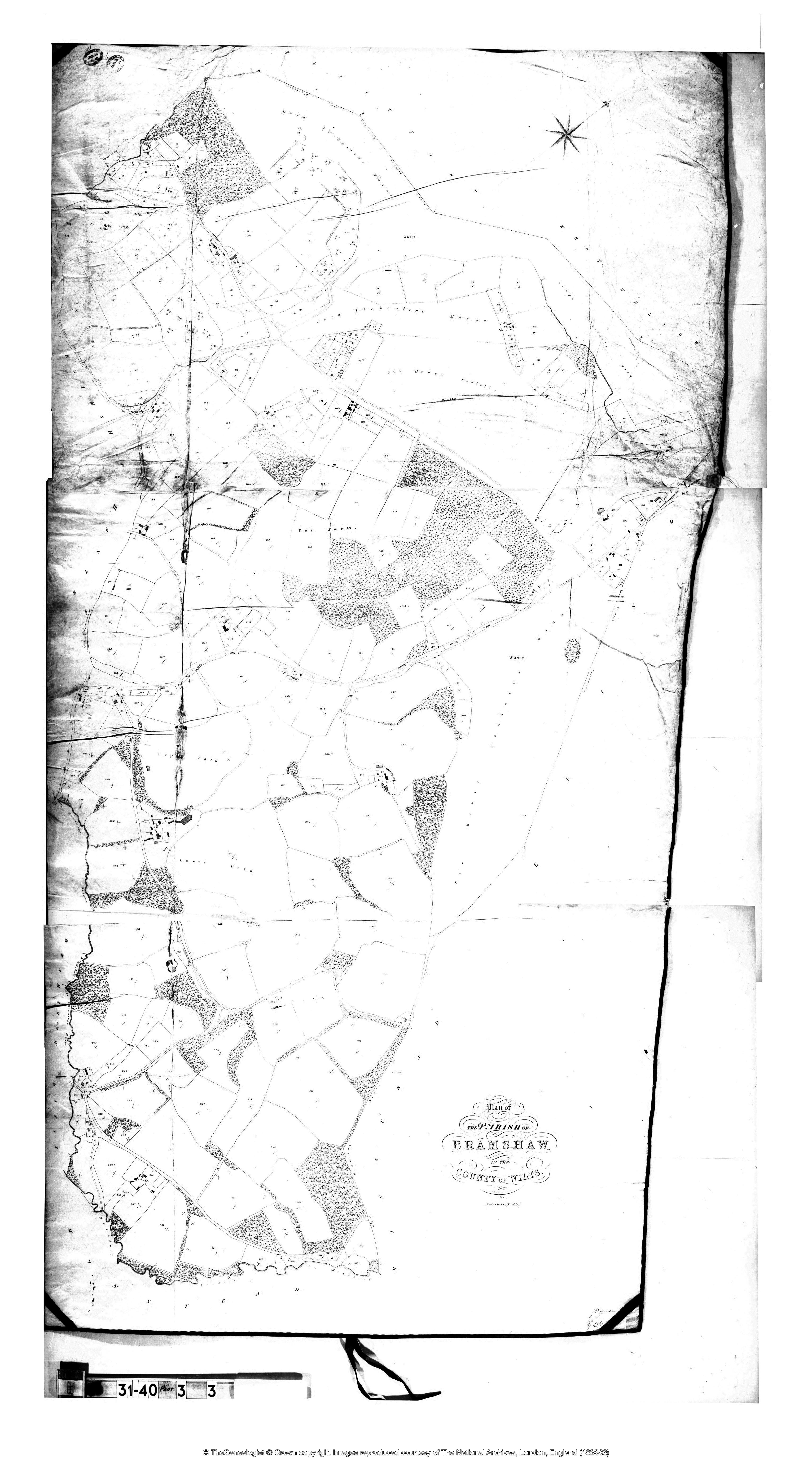
From Part 3 of the map the manors of Sir Henry Paulton and Lord Ilchester appear to have been ignored.
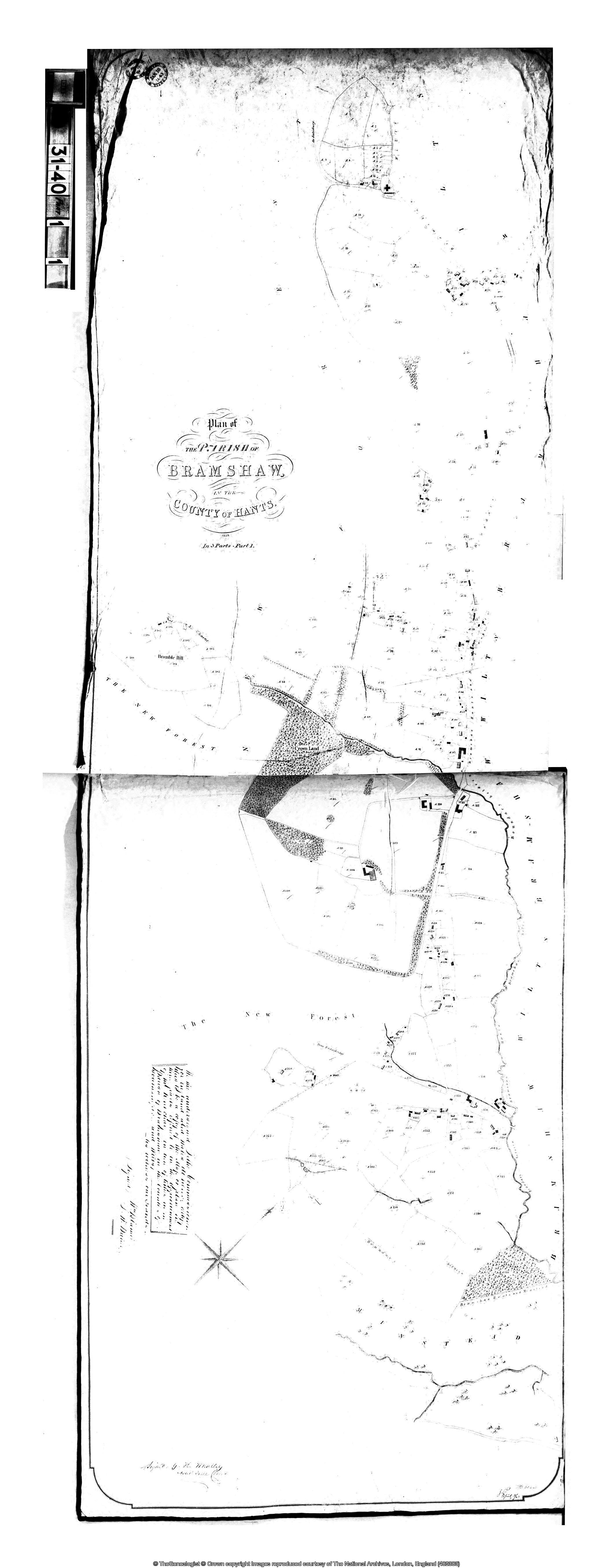
I realise that it is strange to start with Part 3 of 3 Parts.
Part 1 is below.
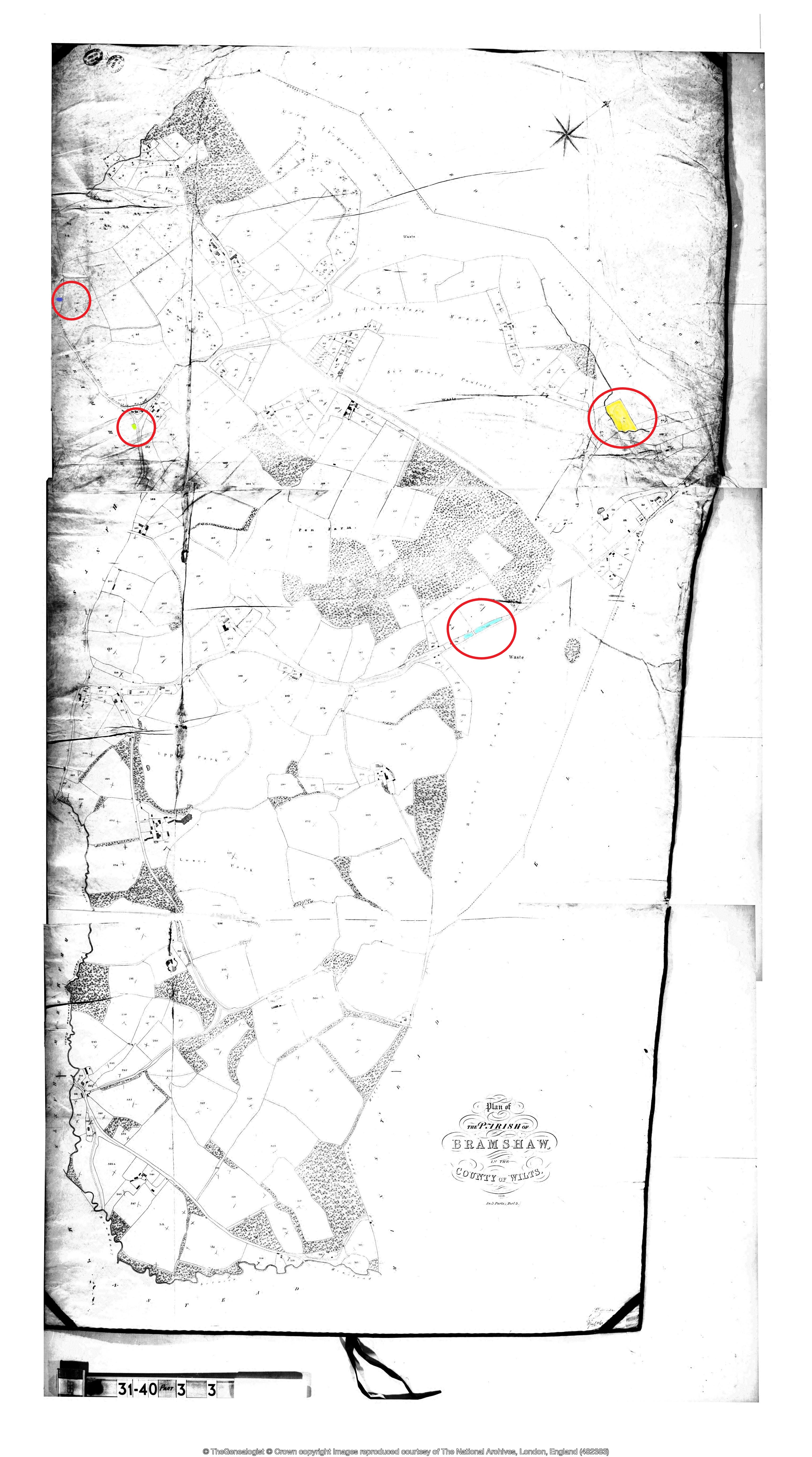
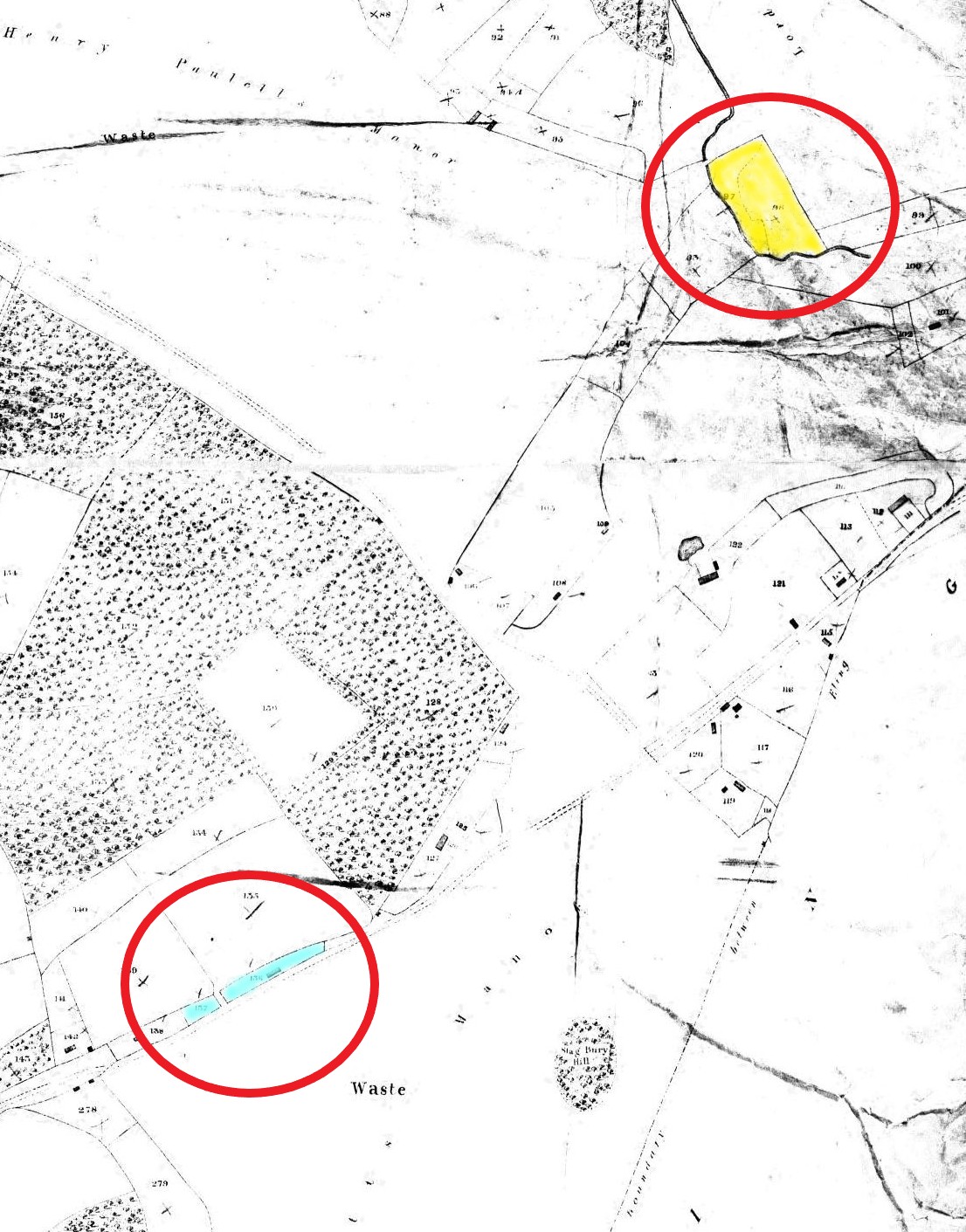
The same map as above but with colour shading added to Biddlecombe entries.
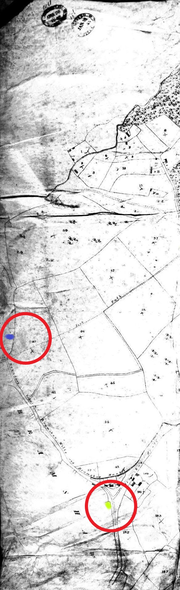
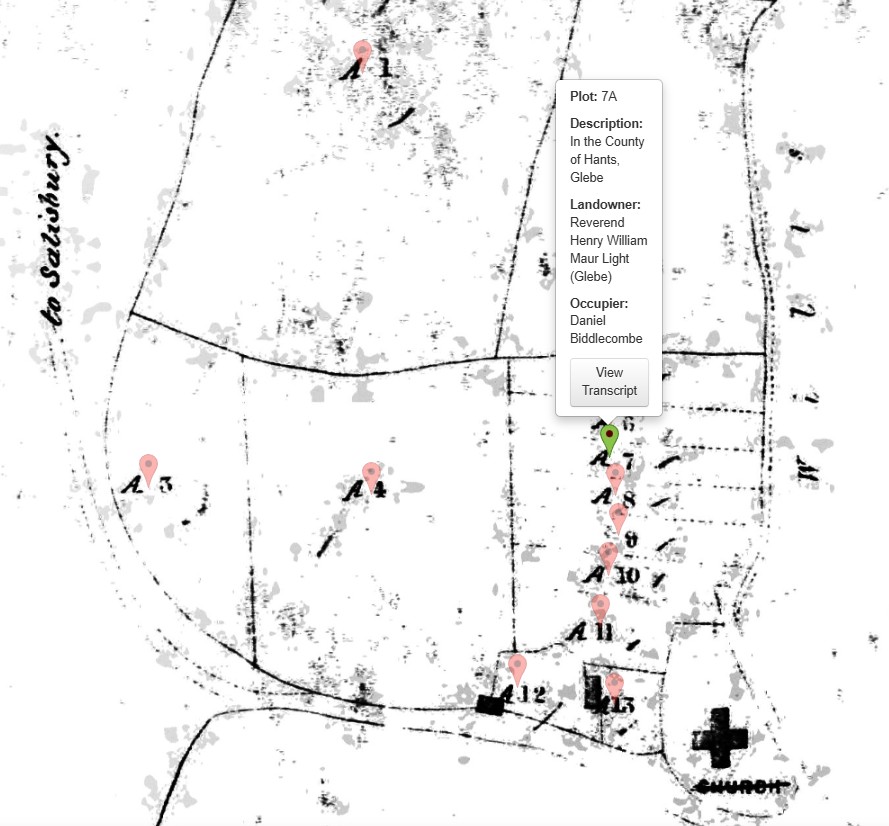
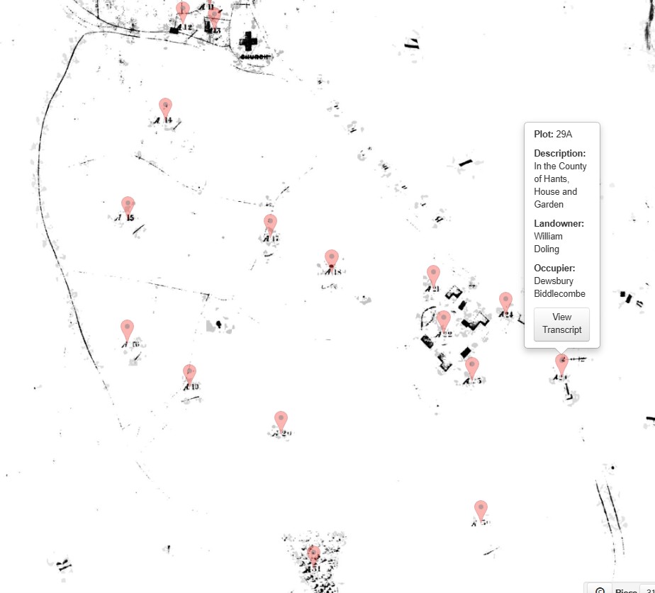
Approximate positions of Plot 29A in lime green and 7a in blue, both off the survey of this part 3 of 3 map.
See Part 1 of the map for more details
|
|
|||||
| Part of Parish of Bramshaw Tithe Map Part 3 - (Wiltshire) 1839 | |||||
|
Plots 97 and 98 in yellow. Plots 136 and 137 in light blue. |
|||||
|
|||||
 |
|||||
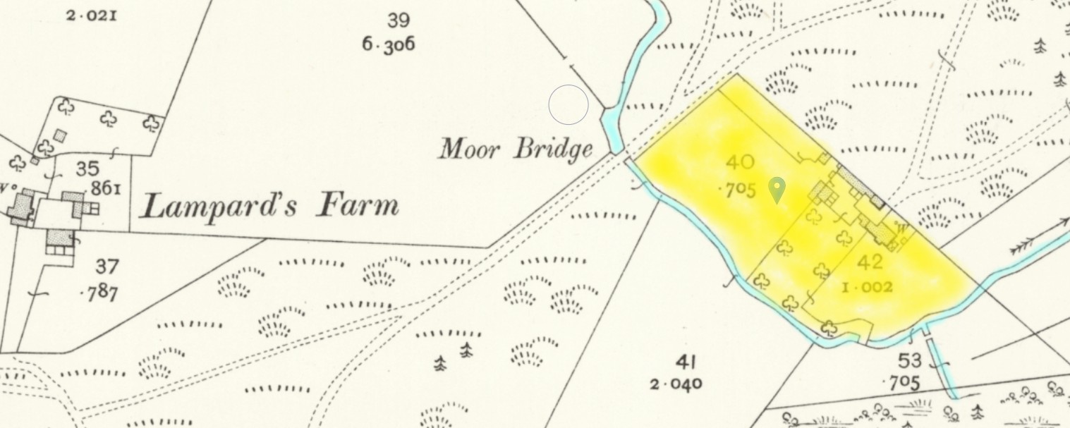
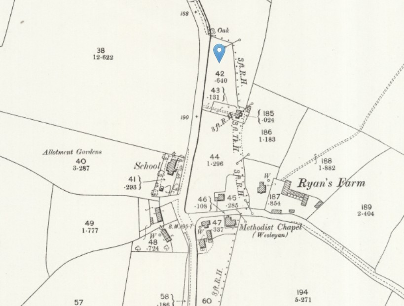
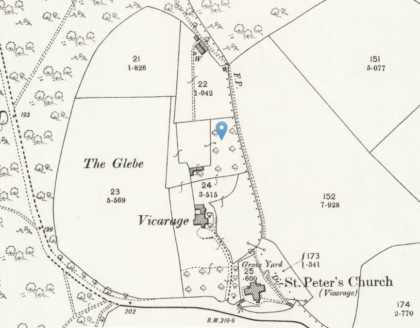
| Part of OS 25" Map Second Edition - Hampshire and Isle of Wight LVI.13 Revised: 1908, Published: 1909 | |||||
| Click on OS maps to go to source in a new window. | |||||
 |
|||||
| Part of OS 25" Map Second Edition - Hampshire and Isle of Wight LVI.13 Revised: 1908, Published: 1909 | |||||
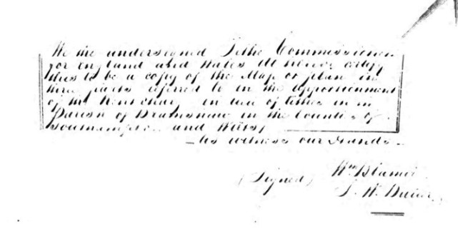
We the undersigned Tithe Commissioners for England and Wales do hereby certify this to be a copy of the Map or plan in three parts referred to in the Apportionment of the Rent Charge in lieu of tithes in the Parish of Bramshaw in the Counties of Southampton and Wilts.
As Witness our Hands
|
|
|
|
| Part of Parish of Bramshaw Tithe Map Part 1 - (Hampshire) | Part of OS 25" Map Second Edition - Wiltshire LXXVII.16 Revised: 1900, Published: 1901 | |
| Landowner Reverend Henry William Maur Light (Glebe) Occupier Daniel Biddlecombe Parish Bramshaw County Hampshire (Partly In Wiltshire) Original Date 16th May 1839 Description of Land In the County of Hants, Glebe Quantities In Statute Measure 0,1,0 Plot 7A Reference IR 29/31/40 |
Click on OS maps to go to source in a new window. | |
|
|
|
|
| Part of Parish of Bramshaw Tithe Map Part 1 - (Hampshire) 1839 | Part of OS 25" Map Second Edition - Wiltshire LXXVII.16 Revised: 1900, Published: 1901 | |
| Landowner William Doling Occupier Dewsbury Biddlecombe Parish Bramshaw County Hampshire (Partly In Wiltshire) Original Date 16th May 1839 Description of Land In the County of Hants, House and Garden Quantities In Statute Measure 0,0,20 Plot 29A Reference IR 29/31/40 |
||
 |
 |
|
| Part of OS 25" Map Second Edition - Hampshire and Isle of Wight LVI.13 Revised: 1908, Published: 1909 | ||
 |
||
 |
||
| Part of Parish of Bramshaw Tithe Map Part 1 - (Hampshire) 1928 | ||
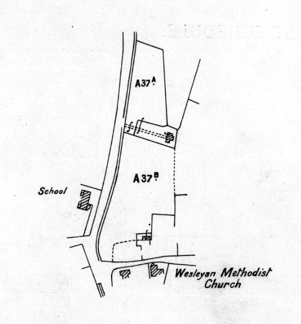
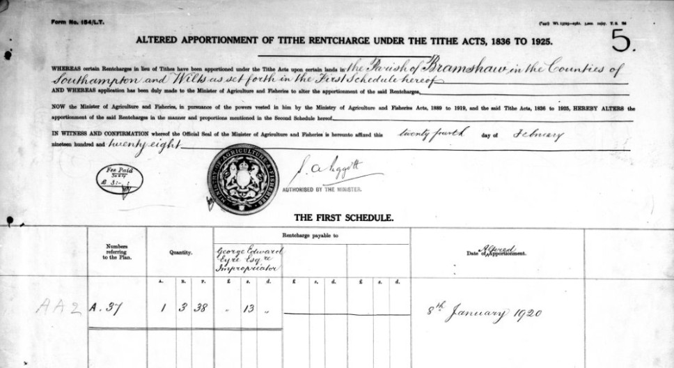
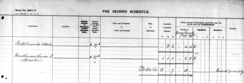
| Landowner Albert Biddlecombe Parish Bramshaw County Hampshire (Partly In Wiltshire) Original Date 16th May 1839 Altered Apportionment Reference AA5 Altered Apportionment Date 24th February 1928 Plot A37A Reference IR 29/31/40 |
...
Spare
...
Records
xxxxxxxxxxxxxxxxxxxxxxxxxxxxxxxxxxx
The names found in the Tithe Records for Bramshaw
| Landowner John Fuller Occupier John Biddlecombe Parish Bramshaw County Hampshire (Partly In Wiltshire) Original Date 16th May 1839 Description of Land In the County of Wilts, Part of Rough Piece Quantities In Statute Measure 0,2,38 Altered Apportionment Reference 003 Plot 97 |
Landowner John Fuller Occupier John Biddlecombe Parish Bramshaw County Hampshire (Partly In Wiltshire) Original Date 16th May 1839 Description of Land In the County of Wilts, Rough Piece Quantities In Statute Measure 1,0,35 Altered Apportionment Reference 003 Plot 98 |
Landowner Moses Biddlecombe Occupier Moses Biddlecombe Parish Bramshaw County Hampshire (Partly In Wiltshire) Original Date 16th May 1839 Description of Land In the County of Wilts, Cottage and Garden Quantities In Statute Measure 0,1,19 Altered Apportionment Reference 003 Plot 136 |
Landowner Moses Biddlecombe Occupier Moses Biddlecombe Parish Bramshaw County Hampshire (Partly In Wiltshire) Original Date 16th May 1839 Description of Land In the County of Wilts, Plot Quantities In Statute Measure 0,0,20 Altered Apportionment Reference 003 Plot 137 |
|
| Occupier in 1839 | Occupier in 1839 | Landowner in 1839 | Landowner in 1839 | |
| Probable DOB / DOD range | Probable DOB / DOD range | Probable DOB / DOD range | PProbable DOB / DOD range | |
| 1839 - 20 = 1819 + 80 = 1899 | 1839 - 20 = 1819 + 80 = 1899 | 1839 - 30 = 1809 + 80 = 1889 | 1839 - 30 = 1809 + 80 = 1889 | |
| Landowner Reverend Henry William Maur Light (Glebe) Occupier Daniel Biddlecombe Parish Bramshaw County Hampshire (Partly In Wiltshire) Original Date 16th May 1839 Description of Land In the County of Hants, Glebe Quantities In Statute Measure 0,1,0 Plot 7A |
Landowner William Doling Occupier Dewsbury Biddlecombe Parish Bramshaw County Hampshire (Partly In Wiltshire) Original Date 16th May 1839 Description of Land In the County of Hants, House and Garden Quantities In Statute Measure 0,0,20 Plot 29A |
Landowner Albert Biddlecombe Parish Bramshaw County Hampshire (Partly In Wiltshire) Original Date 16th May 1839 Altered Apportionment Reference AA5 Altered Apportionment Date 24th February 1928 Plot A37A |
||
| Occupier in 1839 | Occupier in 1839 | Landowner in 1928 | ||
| Probable DOB / DOD range | Probable DOB / DOD range | Probable DOB / DOD range | ||
| 1839 - 20 = 1819 + 80 = 1899 | 1839 - 20 = 1819 + 80 = 1899 | 1928 - 20 = 1908 + 80 = 1988 | ||
xxxxxxxxxxxxxxxxxxxxxxxxxxxxxx