Biddlecombe families location collection
This article pulls the various location information from the Biddlecombe families into one space. There is a lot of information and it is still growing.
Follow the link to see a heat map of locations in my TNG database.
The map opens with "All Trees" in the top right hand corner of the map. Use the dropdown to select "Biddlecombe One Name Study"
All the information may disappear at that point. Change the date range below the map until some relevant data comes back.
Then just play with the options to see various slices of information. Refresh the page to bring it back to default.
ESRI Story Map
ESRI Story Map
Below is, in part the culmination of my 'perambulation of the borders' of the Canford Manor, plotted on a single map so as to see the true extent of the huge manor. It is a stand alone ESRI Story Map so there will inevitably be repetition.
You can also open the ESRI Story Map An exploration of Biddlecomb(e) families by clicking on the link, which will open a new page.
Planned future additions to the story are the locations of all of the people mentioned in this article for whom I can establish a location. Some are already plotted. Others include Biddlecomb(e)'s with later stories and records. All being slowly expanded.
Scroll down the insert to see the map, which can also be expanded.
Locations b/f from Part Hampshire
Not formed yet.
Locations b/f from Part Hampshire and Dorset
Collection at Part level, Hampshire and Dorset.
The ESRI Story Map is a repeat of elsewhere, so that each element is stand alone.
ESRI Story Map
ESRI Story Map
Below is, in part the culmination of my 'perambulation of the borders' of the Canford Manor, plotted on a single map so as to see the true extent of the huge manor. It is a stand alone ESRI Story Map so there will inevitably be repetition.
You can also open the ESRI Story Map An exploration of Biddlecomb(e) families by clicking on the link, which will open a new page.
Planned future additions to the story are the locations of all of the people mentioned in this article for whom I can establish a location. Some are already plotted. Others include Biddlecomb(e)'s with later stories and records. All being slowly expanded.
Scroll down the insert to see the map, which can also be expanded.
location-section-ringwood-and-ellingham
Collection at Section level, Ringwood and Ellingham, Hampshire.
The ESRI Story Map is a repeat of elsewhere, so that each element is stand alone.
ESRI Story Map
ESRI Story Map
Below is, in part the culmination of my 'perambulation of the borders' of the Canford Manor, plotted on a single map so as to see the true extent of the huge manor. It is a stand alone ESRI Story Map so there will inevitably be repetition.
You can also open the ESRI Story Map An exploration of Biddlecomb(e) families by clicking on the link, which will open a new page.
Planned future additions to the story are the locations of all of the people mentioned in this article for whom I can establish a location. Some are already plotted. Others include Biddlecomb(e)'s with later stories and records. All being slowly expanded.
Scroll down the insert to see the map, which can also be expanded.
Hightowns and Highwood
Hightowns in the Will of Christopher Biddlecomb, together with Highwood in the Will of William Biddlecomb
The address I have given in the first past of the transcription of Christopher Biddlecomb is Lightowns, however, checking back to the script and looking at an old Ordnance survey Map held at the National Library of Scotland, that should probably be Hightowns.
The maps below focus on the original address in Christopher's will. However, Highwood, mentioned below, and another Biddlecomb residence, is so close and just to the north, of Hightown, and shown on some of the maps, that it would be repetitive to show the same maps, but focused on Highwood.
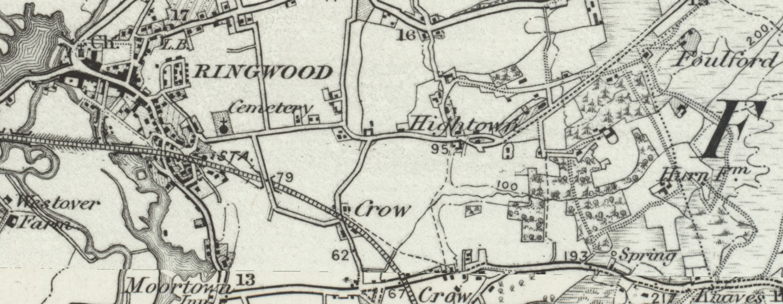
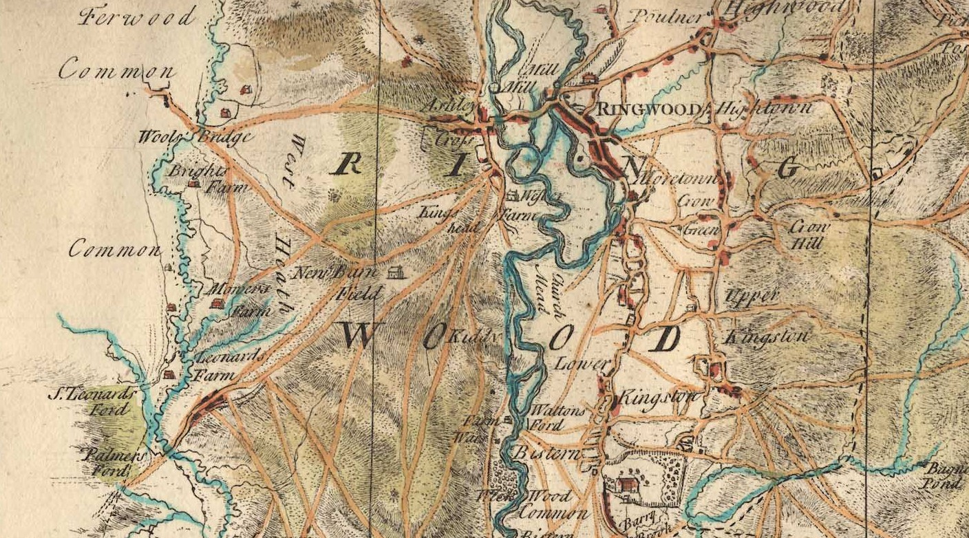
Hightown aka High Town, near Ringwood, Hampshire
Click on most of the maps and a new widow will open, taking you to the source of the map, where you will be able to navigate to both Hightown and Highwood, together with other areas around Ringwood.
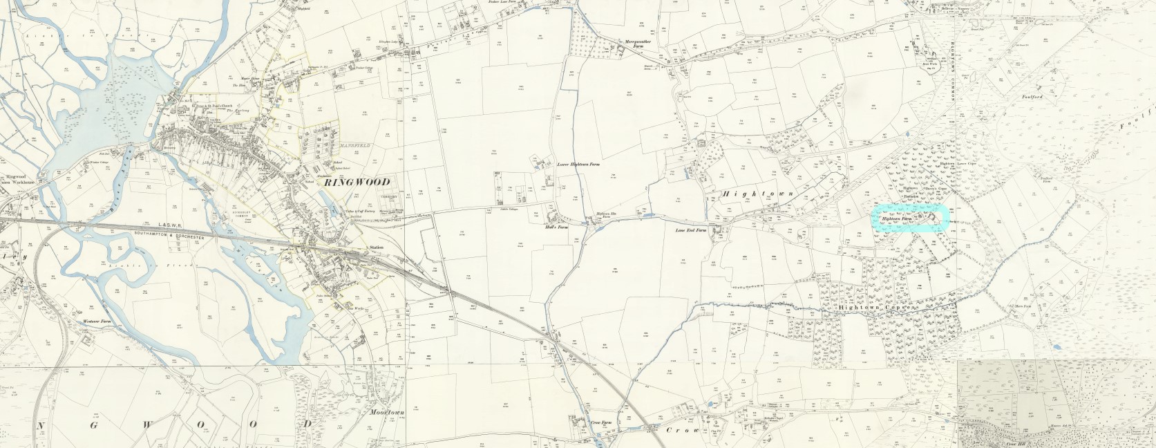
The map above is titled Ringwood (Outline), Sheet 314, Revised: 1894, Published: 1895 and is part of the 1 inch series. A location map before diving into the 25 inch to the mile maps below.
The map below is titled, Hampshire and Isle of Wight LXX.12, Revised: 1895, Published: 1897 I have added a maker for the location of Hightown Farm which may have been Christopher's residence, over 200 years before the map was drawn. It is possible that the farm gave its name to the area surrounding it.
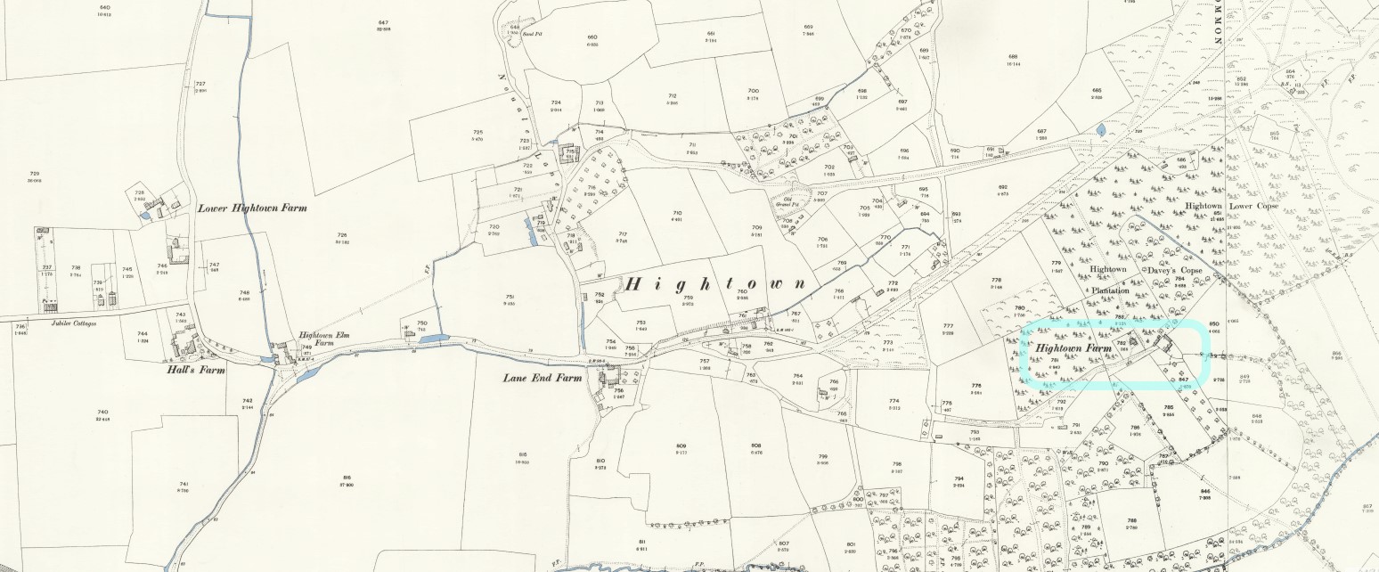
A closer look.
Going back in time to early detailed maps of Hampshire, in several plates, there are Taylor's 1759 and Milne's 1791 Maps. I did look at earlier maps, more contemporary to Christopher Biddlecomb, but they were only detailed enough to locate Ringwood, not the nearby Hightown.
Taylor's 1759 map above has Hightown immediately to the right of Ringwood. There are a few of the larger properties indicated on the map.
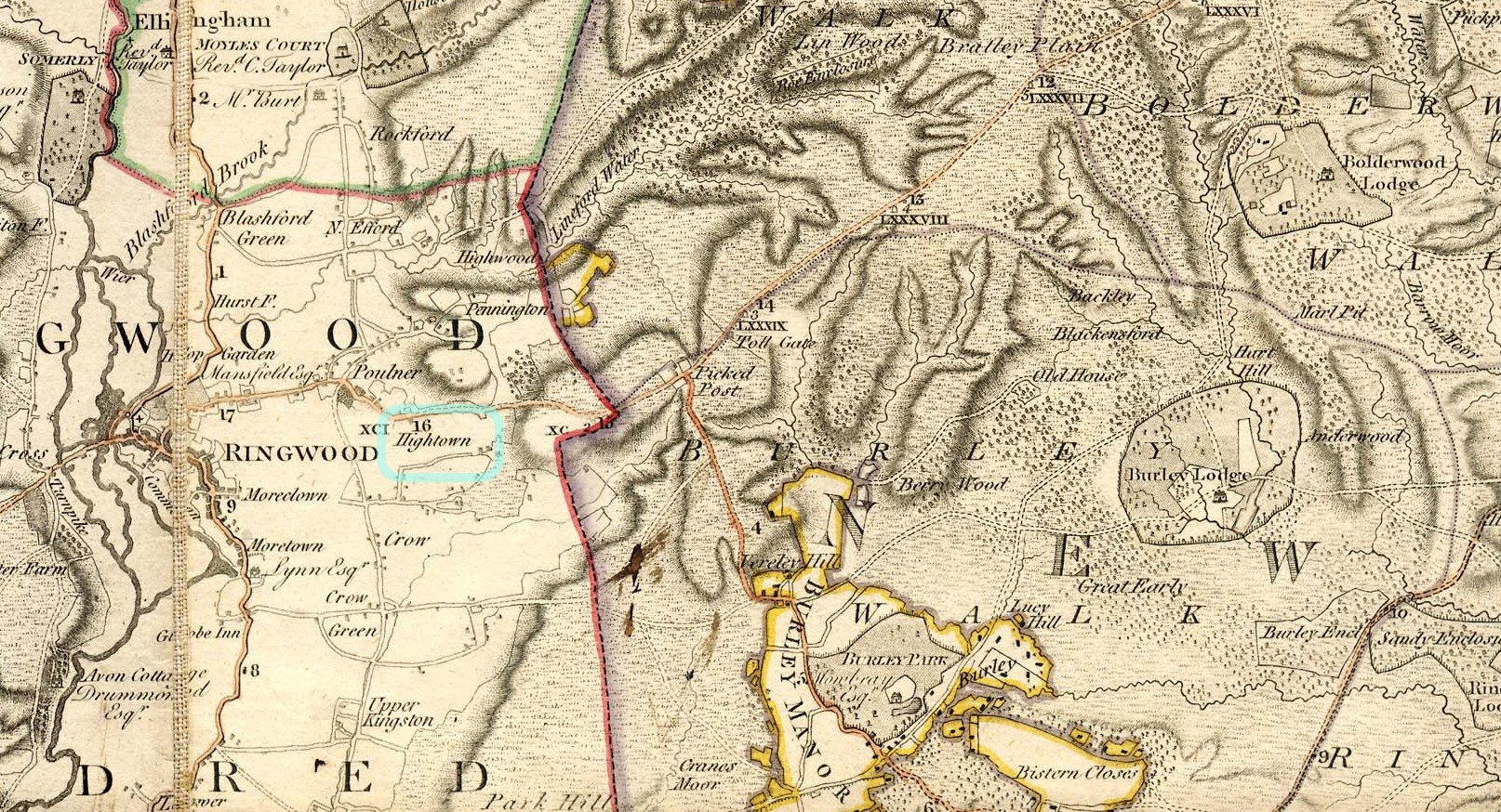
The Milne's 1791 Map also has Hightown shown, circled in blue. In some instances the major landowners of an area are also indicated on the map. However, Christopher Biddlecomb was a yeoman not an Esquire, so he, nor his descendants are included with this honour.
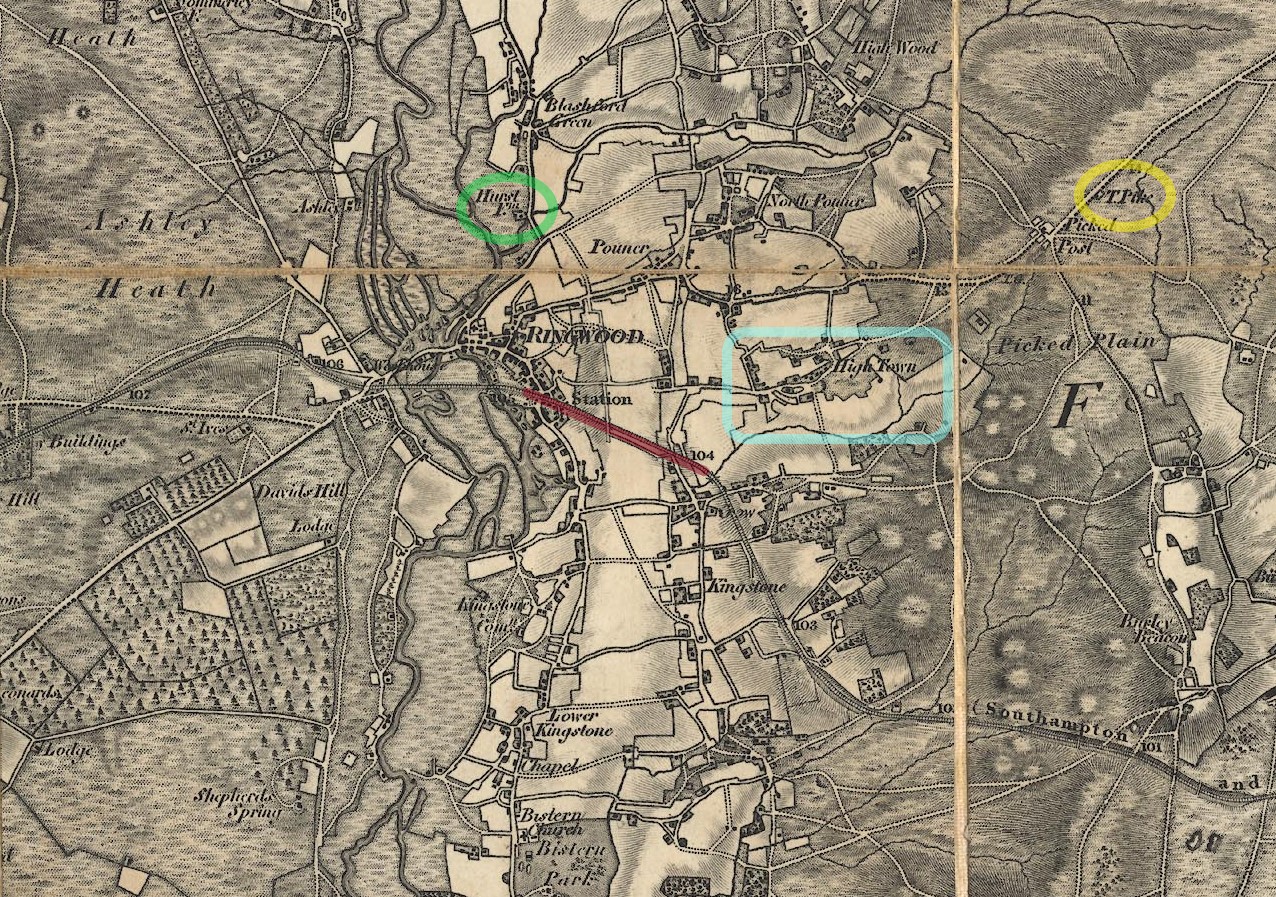
OS First Series, 1810-1855, the railways have arrived. A section highlighted in brown. Hightown or High Town as it is shown, circled in light blue. A turnpike gate circled in yellow, and just because it is my surname, Hurst Farm circled in green. Hightown is evidently expanding, as were almost all other conurbations in the country, as the population grew, and people moved to towns. Away from an agricultural based economy towards an industrial one.
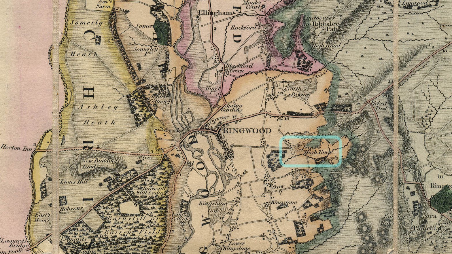
Greenwood's 1826 Map is the last of the Old Maps of the location. Not able to pinpoint Christopher Biddlecomb's actual dwelling place, but a closer idea of how the area around Ringwood, and in particular, Hightown has developed over time.
Rockford
Rockford, Ellingham in the County of Hampshire
Pertaining to the Will of Stephen Rook, husband of Margaret Biddlecomb who was the daughter of Christopher Biddlecomb.

Rockford the village is just under the Parish name of Ellingham. Rockford Farm is the location of marker and the light blue circle. Highwood, which is mentioned in another Biddlecomb(e) will. The distance between Rockford Farm and Highwood is approximately 800 yds, as the crow flies.
location-section-merritown
Collection at Section level, Merritown, Hampshire.
The ESRI Story Map is a repeat of elsewhere, so that each element is stand alone.
ESRI Story Map
ESRI Story Map
Below is, in part the culmination of my 'perambulation of the borders' of the Canford Manor, plotted on a single map so as to see the true extent of the huge manor. It is a stand alone ESRI Story Map so there will inevitably be repetition.
You can also open the ESRI Story Map An exploration of Biddlecomb(e) families by clicking on the link, which will open a new page.
Planned future additions to the story are the locations of all of the people mentioned in this article for whom I can establish a location. Some are already plotted. Others include Biddlecomb(e)'s with later stories and records. All being slowly expanded.
Scroll down the insert to see the map, which can also be expanded.
Merritown, Hampshire and Hampreston, Dorset
The reason for including these locations.
Merritown and Avon, Hampshire and Hampreston and Wimborne Minster, Dorset
Merritown has also been known as Merrietown.
The will of Richard Biddlecombe of Merrietown and the will of John Biddlecombe of Merrytown in the parish of Christchurch Twyneham in the County of South’t are the focus of this location tab. The County stated was an abbreviation of Southamptonshire, now known as Hampshire. The parish of Hampreston, Dorset is also mentioned in both Wills. Despite being in different counties the two locations are relatively close together.
Richard Biddlecombe

In the name of God Amen I Richard Biddlecombe of Merrietown or Merristowne within the parish of Christchurch in the County of South.
With South being an abbreviation of Southamptonshire, now called Hampshire.
From the above, Richard's primary location is Merritown, as it is now known.
Other Lands mentioned in Richard Biddlecombe's Will


I Richard Biddlecombe of Merrytown within the parish of Christchurch in the County of South Yeoman ...
Item I give to my Son Thomas Biddlecombe my ??? and Land at Hampreston
Item I give him one hundred pounds to be paid within the space of two years after my Decease
Item I give him ???? ??? half the rent or profit of my ??? at Avon ???? the two ????
...

I Richard Biddlecombe of Merrytown within the parish of Christchurch in the County of South Yeoman ...
Item I give to my grandchild Martin Biddlecombe fifty pounds ...
Side Cast
Item I give to my grandchild Martin Biddlecombe my land at Wimborn Minster but if ??? ??? ??? got ??? to ??? its before ?? ?? 21 years of age my will ?? ?? go ?? it ??? ??? the money for it.
...
From the transcription I have managed so far, I have not yet ascertained who inherited the land and property at Merritown
John Biddlecombe

I John Biddlecombe of Merrytown in the parish of Christchurch Twynham in the County of South't
From the above, John's primary location is Merritown, as it is now known, the same as Richard's

I John Biddlecombe of Merrytown in the parish of Christchurch Twyneham in the County of South’t Yeoman ...
Item I give devise and bequeath unto my sonn Marten Biddlecombe all my Land and estate that I have and am possessed of lying at Merrytown aforesaid and at Moours? xxxx Srabottd? with their and either of their apperstnanted?? And hath to him his heirs and assignes and forever upon xxx ...
All the rest of my goods and chattels whatsoever moveable and unmovable xxxx my debts and funeral expenses being discharged I give and devise and bequeath unto my sonn Martin Bibblecombe whom I nominate and appoint to be my full and whole Executor of this my last will and Testament ...
On to the locations mentioned in the wills.
Merritown Hampshire
Previously known as, Meadow Town and Merriton, with the change taking place between the Milne's 1791 and the Ordnance Survey map of about 1810 and the Greenwood's 1826 Map. Chaning again to Marritown for the 1896 OS 25" map.
 NLS OS Map - Bournemouth (Outline), Sheet 329, Revised: 1893, Published: 1895
Old OS Map held by the National Library of Scotland. Merritown circled in light blue and Hampreston in red. Bottom right has Holdenhurst circled in green. The county boundary at the time of the map has been highlighted in yellow, with Devon on the left and Hampshire, which was sometimes known as Southamptonshire, on the right of the yellow line. The River Stour has also been given a blue wash.
Going further back in time towards the dates of the Wills with the help of Old Hampshire Mapped. It is worth visiting the site just to look at the excellent maps of the past. They were not a accurate as more recent one but the engravings are superb.
 Saxton's 1575 New Forest Hampshire
Starting with Saxton's Hampshire 1575. or part of it in the area of the New Forest. A blue ring captures Christchurch and Avon. With red rings drawing your attention to Ringwood, Ellingham, Boldre, and Eling
 Taylor's 1759 Meadow Town Hampshire
What is called Merritown on the old OS Map above, is when you go further back in time, to Taylor's Hampshire 1759, called Meadow Town. Circled in light blue.
 Milne's Hampshire 1791 Meadow Town
On Milne's map of Hampshire 1791 Meadow Town is still the name in use, again circled in light blue. Milne's map is also useful in having primary landowners added as well as places and towns. Holdenhurst is circled in green just to aid comparative location with other maps.
 OS Old Map Series Hern Hampshire 1810s
On an early Ordinance Surrey 1" map the name of the place has changed from Meadow Town to Merriton Farm, still circled in light blue. Avon is circled in brown and the route between them named here as Avon Cross Way, latterly known as Avon Causeway.
From a current Google map Merriton Farm to Avon, is about 3.8 miles, with a walking time of 1 1/4 hours.
 Greenwood's Hampshire 1826 Merriton Fm
The last map from Old Hampshire Mapped is Greenwood's Hampshire 1826, which has a direct placing of Merriton Farm, the same as the OS Map.
 OS 25 Old Map Merritown Hampshire -- Hampshire and Isle of Wight LXXVIII.14, Revised: 1896, Published: 1898
A bigger scale map and Merritown and Merritown Farm are clearly shown. The name has changed again with the ton at the end becoming town.
Avon and Sopley
 OS 25 NLS Old Map Avon Hampshire
 OS 25 NLS Old Map Merritown, Avon, and Sopley, Hampshire
Merritown Farm and Merritown circled in light blue, Avon in brown and the yellow circle is around the village of Sopley. Sopley Park and the parish of Sopley extend beyond the circle. The three together gives an idea of close proximity.
Sopley is the subject of a previous article, entitled Sopley and the Domesday Book.
Hampreston
I have not yet found an Old Dorset Mapped or anything similar to Old Hampshire Mapped which would enable me to map Hampreston through the centuries.
Also, Hampreston is a larger settlement, and a parish, so I don't know specifics of location in the same way as Merritown.
 OS 25 Old Map Merritown Avon and Sopley Hampshire and Hampreston Dorset
Again, a map not to show detail, zoomed out to far, but to show comparative locations. To see detail click on the map to travel to the National Library of Scotland, to see the map, without the coloured circles. Merritown Farm and Merritown circled in light blue, Avon in brown and the yellow circle is around the village of Sopley. Sopley Park and the parish of Sopley extend beyond the circle. Hampreston in Dorset is circled in red.
 OS 25 Old Map Hampreston Dorset - Dorset XXXV.10, Revised: 1900, Published: 1901
The village of Hampreston and the surrounding fields.
Wimborne Minster
 OS 25" NLS Old Map Wimborne Minster Dorset - Dorset XXXV.5, Revised: 1900, Published: 1901
 OS 25" NLS Old Map Wimborne Minster Hampreston Merritown Avon
The relative positions of Wimborne Minster and Hampreston, both in Dorset and Merritown and Avon, both in Hampshire. Wimborne Minster is much larger than the other places but Merritown remains the focus.
Four of the five places mentioned in the Wills of Richard and John Biddlecombe. The fifth place, the transcription alludes me, is yet to be plotted.
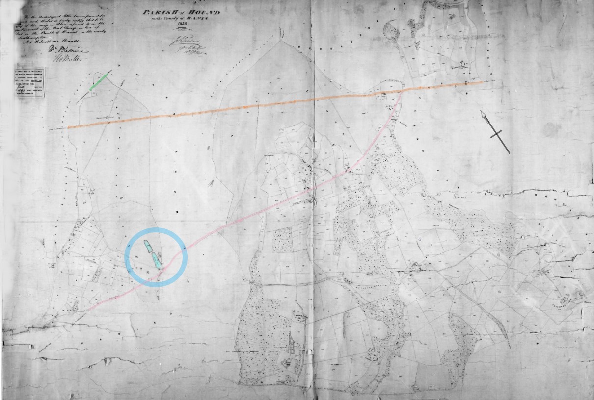
There is a Tithe Map covering Merrritown, extract below.
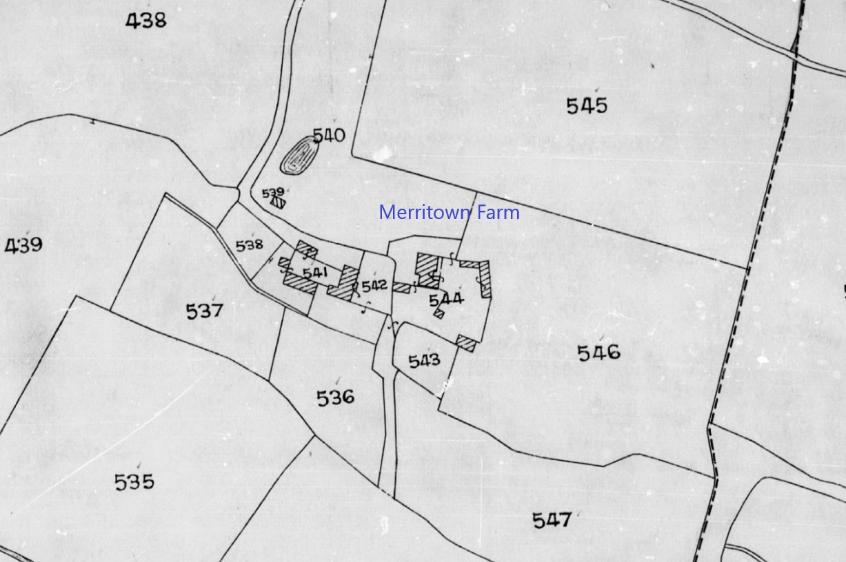
I have added the text, Merritown Farm, in blue. It is rarely that easy to identify places on Tithe Maps. However, in this instance it is further complicated insofar as the plots around Merritown Farm are not indexed, which makes finding the Landowner and Occupier for the Tithe Record date of 18th September 1838, difficult.
If the landholding is still together, knowing the landowner of one area could help establish the location of the as yet unidentified fifth place. Muckleshell is the area of plot 544 in the Holdenhurst sub-area. Or perhaps Muscliff and Throop. Neither look like the words in the will.
Canford Manor
Canford Manor, near Hampreston, Dorset
This may not have anything to to with the Biddlecomb family. However it is being explored due to the Will of John Biddlecomb of Merrytown.
Above is an extract of his will, where he 'bequeath unto my son Martin Biddlecomb all my land and estate ... at Merrytown and at ????' In another part of the will he provides for the poor of the parish of Hampreston in addition to those of Christchurch. Perhaps his other lands are near Hampreston.
Hence looking in the vicinity of Cranford Manor, and how I came across the following extract from Poole History.
Canford Manor 1571
Description of the bounds included in a Survey of the lands of the Manor.
The Perambulations and Bounds of the Manner of Canfford.
“ Fyrste hyt begynnethe at Gallowe Poole nyghe to Rydlesforde and so as the dyche leadeth to Walfforde yn the East part. And from thence to a Stone nyghe unto Dyrley Chine yn the Moore upon a lytle bancke. And from thence as the Water runeth downe Durley cheine yn to the Sea. And from thence by the Sea to Northehaven fronte and so along by the Sea to Tyrland. And from thence to the stone yn Rushe Moor and so to the Stomped Crosse and from thence to Crechmear and as the Moore lyethe to the Weaste gate of Upton. And as the lane leadeth to the northe gate of Upton. And from thence as the Dyche runnythe to Cherwell water. And as the water runethe to Gyllynghame Mylle. And from thence along the Ryver to Julyans Brydge. And so to Allyns Brydge. And from thence to Holman Stubbe and from thence to the corner of the Lytle parke and to the northe parte of Breacke. And so downe to the Stower. And as the Stower runnethe to Rydlesforde where we began.
Transcription based on a handwritten copy of the Survey prepared in 1897 for Lord Wimborne.
It has taken a good while but I believe that I may have found Rydlesforde.
Both on Milne's 1791 map ant the later OS 25" map.

Riddles Ford is circled in blue on the Milne's 1791 map above. Circled in orange is Wellingford, could this be an alternative spelling to the latter of the two names in this extract, ' ... Rydlesforde and so as the dyche leadeth to Walfforde ...? Another ford on the Hampshire boarder?

Riddles Ford is not very far away from Merritown or Merrytown.

 A mere 1 1/2 miles as the crow flies, just the issue of the River Stour between them.

After Riddles Ford, as the text indicates ' Rydlesforde and so as the dyche leadeth to Walfforde yn the East part.' Could that name have morphed into Walkford? There are several Walkford named places in the vicinity of Walkford Farm. Walkford also fulfils the 'in the East' element as it is only slightly south of due east, about 8 1/2 miles away.


Neither Canford Cliffs nor Canford Cliffs Chine, both shown on the above map, are mentioned in the Canford Manor boundary walk, but the names suggest a link.
Durley Chine is also on the list around the boundary

 Durley Chine on a First Series OS one inch map, circled in blue. Note the absence of Bournemouth, as a town.


Over seven miles between Canford Manor and North Haven Point. Is this the same place as in the transcription? It does refer to the sea, so it could be.

This map is for Upton, both western gate (not shown) and northern gate.

The next place found was Julian's Bridge, 'And from thence along the Ryver to Julyans Brydge.'
The perambulation continued thus;
... And from thence along the Ryver to Julyans Brydge. And so to Allyns Brydge.
As part of the research for Canford Manor. Presumably Allyns Brydge could be Allins Brridge, or a bridge over the River Allen.
The River Allen flows from the north to Wimborne Minster, where the river joins the Stour. There are two bridges across the River Stour and three bridges across the River Allen, in Wimborne Minster.
There is Julian's Bridge above and Canford Bridge, below.

Going upstream along River Allen, from Canford Bridge, the next mapped bridge appears to be at East Street. Possibly two bridges, one for the river and another for the mill stream, although the latter may have been more of a culvert. However, to help with the continuity of the maps, the East Street bridge in in the third image below. The three maps are on top of one another and almost join together. I could have done it in one map but without the joins, but the detail would have been difficult to discern.
At the top is Walford Bridge and Mill. The other bridges across the Riven Allen are un-named as far as this map is concerned. I have given the river a colourwash to ease identification.


Above is a Google StreetView image of the upstream side of East Street Bridge in Wimborne Minster, and adjacent, the bridge viewed from downstream.
Beneath is another Google StreetView slightly further along East Street, as the mill stream disappears under the road.

Walford Bridge is on the outskirts of Wimborne Minster according to the map, and is adjacent to corn mill of the same name.
Returning to tracing the river Allen upstream on the map, the next shown bridge is the 'Bull Bridge' at Wimborne St Giles.

Unfortunately, there is not enough information the identify 'And so to Allyns Brydge.' It could be any of the bridges, apart from Walford Bridge. Well actually it could have been that bridge as well, if it changed name.
Also, unfortunately, I have not been able to find the remaining places on the boundary walk. There are probably enough to give a sense of the extent of the Manor in 1571 as described, but not definitive. It has however, been an interesting exercise, although it did not help locate the second place mentioned in John Biddlecomb's will, starting with an M and looking like Moonre with something on the end. Time to stop and move on.
Canford Magna
Canford Magna Dorset
Kingston Canford Magna
Kingston Canford Magna
Kingston Tything in the Parish of Canford Magna in the County of Dorset
Also know as Kingstone and Kinson
Kinson is a tithing and ecclesiastical parish formed in 1865 out of Great Canford parish.
Kinson is a parish on the south bank of the River Stour. It was part of the great parish of Canford Magna until 1865 and it became part of the borough of Bournemouth in 1931. The site was recorded in Saxon times and the area of alluvial soil from the river flood plain was ideal farming land. The south of the parish was part of the great Dorset heathland and provided furze for fuel and rough pasture.
Before the Norman conquest the name was Cyneston, the Saxon name for a farm. By the time of Domesday the name had changed to Chinestanestone and the following was recorded:
Edward also holds Chinestanestone. Wulfen held it before 1066. It paid tax for 13 hides. Land for 9 ploughs, of which 5 hides and 1 virgate of land are in the lordship; 2 ploughs there: 7 slaves; 18 villagers, 14 cottagers and 4 cottagers with 7 ploughs. A mill which pays 5s.; woodland, 1 acre; meadow, 100 acres, less 5; pasture 3 leagues long and 2 leagues wide, less 3 furlongs.
The parish name changed a number of times over the next 900 years Kynestanton - Kinestaneston – Kenstaneston – Kinstanton – Kynston – Kingston How – Kingston until finally settling on Kinson in the early 20th century.
The reason for including these locations.
Kingston in the Parish of Corfe Castle and Kingston in the Parish of Canford Magna, both in the County of Dorset
The first is to avoid confusion between the two Kingston places in the County of Dorset.
Kingston in the Parish of Canford Magna
I Henry Biddlecombe of the Tything of Kingston in the Parish of Canford Magna in the County of Dorset Yeoman ...

On to the location mentioned in the will, together with the Kingston of Corfe Castle.


The two Kingston places were about 121/2 miles apart, with Kingston in the Parish of Canford Magna shown as Kinson on the above map.
At the time of the Greenwood Maps there were two places called Kingston in the County of Dorset as can be seen in the following maps.
Greenwood Atlas Dorset


Greenwood Atlas Dorset South East

Greenwood Atlas Dorset South East Corfe Castle and Wareham

Greenwood Atlas Dorset South East Corfe Castle

Greenwood Atlas Dorset South East Canford Magna

Greenwood Atlas Dorset South East Canford Magna and Hampreston Parishes

Greenwood Atlas Dorset South East Canford Magna Kingston and Ham Preston

One Kingston, and the one found on the OS Map 25" above is near Corfe Castle. Another, which is shown as Kinson on the OS Map 25". Kinson was previously Kingston in the Parish of Canford Magna. Kinson was a tithing but subsequently separated into a Parish of that name. Shown in the County Parish Maps below.
County map of Parishes - Dorset
Extract from Great Britain, Atlas and Index of Parish Registers, from Ancestry


Dorset South East, Hampshire Border
Ecclesiastical Jurisdictions; Red Boundary, Archdeaconry of Dorset. Yellow boundary, Other Peculiars. Blue Boundary, Sarum and Royal Peculiars.

Canford Magna Area
Ecclesiastical Jurisdictions; Red Boundary, Archdeaconry of Dorset. Yellow boundary, Other Peculiars. Blue Boundary, Sarum and Royal Peculiars.


From the above OS 6" map from the National Library of Scotland, with additional labels, in is apparent the close proximity of Kingston and other places of interest, Merritown, Hampreston, together with Canford Manor and Canford Magna.
Tithe Maps
Searching the Tithe Apportionment for the whole of Dorset, which would be about 1840 to 1845. The parishes that returned any Biddlecom??? were;
- Charmouth
- Thorncombe
- Bothenhampton
- Loders (Except West End)
Accordingly there are no Tithe Maps included here.
Historical Description
Kingstone or Kinson, a village in Dorsetshire. It stands on the river Stour, 1¾ mile W of the boundary with Hants, and 5 miles ESE of Wimborne station on the S.W.R., is a considerable place, and has a post, money order, and telegraph office under Wimborne. Acreage, 5340; population of the civil parish, 7295; of the ecclesiastical, 3565. The living is a vicarage in the diocese of Salisbury; gross value, £280 with residence. Patron, Lord Wimborne. The church is a Norman building of stone restored in 1894. There are Congregational and Wesleyan chapels. At Newtown is a small hospital opened in 1889. The church of St John the Evangelist at Kinson Heath was erected in 1881; it is a plain brick building in the Early English style. The living is a vicarage; net value, £85. Patron, Lord Wimborne. The church of St Clement's, Newtown, was built in 1889, and is in Early English. St Mark's, in Talbot village, was built in 1870 by Miss Talbot, who founded the village. It contains a beautiful font which was dug up in the river Tiber. The tower has a fine clock and a peal of bells.
Bidcombe Mill
No direct reference yet found to Bidcombe Mill, just a similarity in name.

I found Bidcombe Mill whilst tracing the route of the River Allen from Wimbourn Minster, where the river joins the Stour, on an old 25" old OS looking for;
The Perambulations and Bounds of the Manner of Canfford.
... And from thence along the Ryver to Julyans Brydge. And so to Allyns Brydge.
As part of the research for Canford Manor. Presumably Allyns Brydge could be Allins Brridge, or a bridge over the River Allen.

Interesting, but probably coincidental, the proximity of Stanbridge Mill, circled in yellow, to Bidcombe Mill. At a guess Stanbridge Mill would have been part of the Stanbridge Estate which is the subject of another part of this website. Equally, it could have derived it's name from the hamlet of the same name about 31/2 miles to the south. Stanbridge Hall is approximately 22 miles away in a vaguely East North East direction.


Stanbridge Hall was, together with a lot of surrounding land the subject of the will of 'Fifield, John of Standbridge otherwise Standbridge Erles in the parish of Romsey, Gentleman' A gentleman attached to my Family Tree.
Locations b/f from Part Dorset
Not formed yet.
Locations b/f from Part Dorset, Devon and Somerset
Collection at Part level, Dorset, Devon and Somerset.
The ESRI Story Map is a repeat of elsewhere, so that each element is stand alone.
ESRI Story Map
ESRI Story Map
Below is, in part the culmination of my 'perambulation of the borders' of the Canford Manor, plotted on a single map so as to see the true extent of the huge manor. It is a stand alone ESRI Story Map so there will inevitably be repetition.
You can also open the ESRI Story Map An exploration of Biddlecomb(e) families by clicking on the link, which will open a new page.
Planned future additions to the story are the locations of all of the people mentioned in this article for whom I can establish a location. Some are already plotted. Others include Biddlecomb(e)'s with later stories and records. All being slowly expanded.
Scroll down the insert to see the map, which can also be expanded.
location-section-thorncombe-and-winsham
Collection at Section level, Thorncombe and Winsham
The ESRI Story Map is a repeat of elsewhere, so that each element is stand alone.
Locations
The location of an event has a significant importance when looking at the past through the lens of a Family Tree. A wide family with the same surname can have many individuals with the same name and approximately the same birth year, particularly with Christian names either generally popular or past down for generations through the family. Each with their own family, and, to confuse things further, frequently with the same names for parents through the generations. Sometimes it is only the location that can separate one John from another.
This section explores some of those locations to help keep the history correct, and to share my exploration and findings.
ESRI Story Map
ESRI Story Map
Below is, in part the culmination of my 'perambulation of the borders' of the Canford Manor, plotted on a single map so as to see the true extent of the huge manor. It is a stand alone ESRI Story Map so there will inevitably be repetition.
You can also open the ESRI Story Map An exploration of Biddlecomb(e) families by clicking on the link, which will open a new page.
Planned future additions to the story are the locations of all of the people mentioned in this article for whom I can establish a location. Some are already plotted. Others include Biddlecomb(e)'s with later stories and records. All being slowly expanded.
Scroll down the insert to see the map, which can also be expanded.
Thorncombe
The reason for including these locations.
Thorncombe in Devon and later Dorset
Thorncombe village, surroundings and parish.
The of John Biddlecombe of Thorncombe in the County of Devon is the focus of this location tab.
John Biddlecombe

In the name of God Amen I John Biddlecombe of a place called Hanplott within the parish of Thorncombe in the County of Devon.
George Biddlecombe
George Biddlecombe is also listed as a landowner in the Tithe Apportionment.
Joseph Aplin
Thorncombe Farm, Fore Street, the home of Joseph, Mary, and Elizabeth Aplin according to the 1841 Census.
James Aplin
According to the 1841 Census James Aplin and family lived at Forde Abby Farm
On to the locations mentioned in the wills.
Thorncombe
Greenwood Atlas of the Counties of England Surveyed 1817 to 1833

Greenwood Atlas Devon

Greenwood Atlas Devon East

Greenwood Atlas Devon East Thorncombe Parish

Greenwood Atlas Devon East Thorncombe

Thorncombe Devon / Dorset
Thorncombe is very near the Devon / Dorset border, and was in Devon but the border has now moved, such that it is now part of Dorset.

Whilst Thorncombe was in Devon at the time of the will of John Biddlecome by the date of the above map, Dorset XIX.15, Revised: 1901, Published: 1903, the county borders had already changed, shown in gold. Dorset centre and right, Devon left, East, and Somerset, top and top right, North. The parish heading for Thorncombe, highlight in light blue, and the village of Thorncombe circled in light blue. The marker represents the location thought to be the home of John Biddlecombe.

Zooming it to the village of Thorncombe on the same map gives more detail.

Moving on to a Tithe Map of the Parish of Thorncombe, signed by the Tithe Commissioners on 25 February 1843. There is a note indicating that the map was repaired 20 November 1961. I have circled Thorncombe village in light blue, to give you some idea of the position within the parish. The village is not labelled as the whole map is plot based.
Thorncombe and John Biddlecombe

Again zooming in Thorncombe village is on the left. It is recognisable by it's shape and roads compared to the above Ordnance Survey Maps. There is an area that I have given a light blue colour wash which represents land register in the Tithe Apportionment as belonging to John Biddlecombe.

Name: John Biddlecombe
Parish: Thorncombe... County: Devon (Now In Dorset)... Type: Landowner... Plan Number: 1051...
and 1052, 1053, 1054.
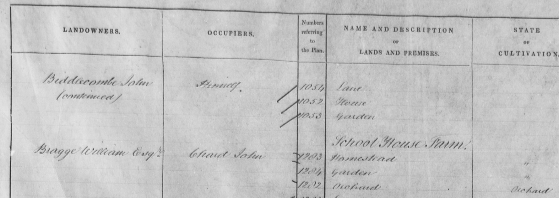
An extract from the associated Tithe Apportionment shows three of the four plots as occupied by himself, with plot 1052 being his house, the building shown on the map adjacent to plot 1051.
Plot 1051 is an orchard of about 1/4 of an acre, rented out as the record below indicates.
Landowner John Biddlecombe
Occupier John Hitchcock
Parish Thorncombe
County Devon (Now In Dorset)
Original Date 3rd November 1841
Plot 1051
Thorncombe and Mary Biddlecombe
Returning to the Ordnance Survey 25" map.

The Tithe map is rather too dark to make out all the plot numbers, but plot 1002 is within the area circled in green on the OS Map above. On the edge of the village towards the land owned by John Biddlecombe. The significance of plot 1002 may be apparent from the below record.
Landowner Mary Biddlecombe
Occupier Mary Biddlecombe
Parish Thorncombe
County Devon (Now In Dorset)
Original Date 3rd November 1841
Plot 1002
From the will of John Biddlecombe it is apparent that his parents are Joseph and Mary Biddlecombe. Perhaps the Mary Biddlecombe in plot 1002 is John's Mother, or alternatively his sister
Thorncombe and George Biddlecombe
George Biddlecombe is also listed as a landowner in the Tithe Apportionment.

The plots identified as his are in two locations, but he is not the occupier according to the records. The relationship of George to John is not yet known. The lefthand patch is around 'New House' in the area of Headstock Cross. The righthand patch is at Greenhill, adjacent to the Turnpike Road, which is now known as Horseshoe Road. At the junction of the High Street towards Thorncombe village.

Again, the OS 25" map with the two areas owned by George Biddlecombe identified in orange. A transition from the Tithe Map of 1841 to the Dorset XIX.15, Revised: 1901, Published: 1903. George Biddlecombe does appear to have a residence in Winsham, Chard, just 3 miles from the village of Thorncombe. There may be an association with George Bowditch, another surname of interest to me. The plots adjacent to Mary Biddlecombe also have adjacent Bowditch families.
George and James Biddlecombe
George and James Biddlecombe also occupy lands in the parish of Shapwick, Somerset. However, that parish is over 30 miles from Thorncombe so could be a different family. George and James are also recorded in the voters register for Shapwick in the same year as George Biddlecombe is registered in the voters register for Winsham. However, I understand that a person could have more than one vote at than time.

Back to the plots owned by John Biddlecombe as identified by the Above Tithe Maps and Apportionment, circled in light blue. The position of the marker in first map in this section, with the county boundaries, and the map beneath that.
Thorncombe Farm
Thorncombe Farm, Fore Street, Thorncombe

Thorncombe Farm, Fore Street, the home of Joseph, Mary, and Elizabeth Aplin according to the 1841 Census.
Looking in more detail at the Tithe Maps for Thorncombe, Joseph Aplin shows as being a Landowner as well as an Occupier. I actually started with the Map and detail, but it is better to present the Summary first.
It is easy to find Aplin as Landowners as the summary is in order of Landowners, and unsurprisingly, A for Aplin is near the top.

Joseph Aplin as a Landowner with ten separate Occupiers plus Himself. Thomas Aplin and William Aplin are also Landowners.

Joseph Aplin is the occupier of over 160 acres from the Landowner John Biagge Esq. His Tithe rent charge to the vicar is almost £22 per year.
James Aplin, with the pink marking, is a much smaller affair from this landowner, a mere 36 perch. Tithe Apportionment only a shilling a year, again to the vicar. For ease of reference 40 perches to a rood, and 4 roods to one acre. Also In 2021, the relative value of £21 18s 5d from 1843 ranges from £2,290.00 to £102,900.00. That is just the Rent Charge to the vicar, to replace the Tithe, not the rent paid to the Landowner for the use of his land.
Moving into the detail;
Joseph Aplin as Landowner, split over two pages, showing his diverse portfolio.


The second page has Thomas Aplin and William Aplin as well as the larger holdings of Joseph Aplin.

Moving on to Joseph Aplin, and he fills almost the whole page with his 163 acres.
The image is difficult to read at this distance, so lets zoom in.

Firstly, the players, John Bragge Esquire (it could be Biagge in some instances within the Tithe Apportionment), as Landowner.
Joseph Aplin as the Occupier.

Very conveniently pulled together under the heading of Thorncombe Farm. Just over 163 acres.
This is what 163 acres looks like. All the above plots of Thorncombe Farm coloured mid-blue.

One plot at the bottom only partially shown, one plot guessed as the number missing in the damaged area and one plot assumed as the transcription seemed questionable.


The red shaded plots indicate that Joseph Aplin is the Landowner and Occupier within the village of Thorncombe. He is also Landowner for the yellow plots, both in the village and in the inset above, but occupied by others according to the Tithe Apportionment. Beside the yellow plots in the inset are brown plots with Landowner William Boon. Not all of the plots could be confidently identified so assumptions have been made.
There are many other plots with potential Biddlecambe wider family members as Landowners and / or Occupiers within the Tithe Apportionment for the Parish of Thorncombe in the County of Devon at the time, but since 1844 part of Dorset.
Forde Abbey Farm
Forde Abbey Farm, Thorncombe (Parish)

According to the 1841 Census James Aplin and family lived at Forde Abby Farm in the Parish of Thorncombe. Presumably the same as the one shown on the above map. Click on the map to go to the source and zoom out to see the location in respect of the village of Thorncombe.

It would be remiss not to pick out Forde Abbey. I have given the River Axe a blue wash, together with the Mermaid Pond at the Abbey. Winsham is not far away, to the north.
To see Forde Abbey as it is today, go to the Forde Abbey website.

The Thorncombe Parish Tithe Map, again with the River Axe and ponds with a blue was, and roads yellow.
The Landowner of Forde Abbey and surrounding area according to the Tithe Apportionment is John Francis Gwyn Esquire. He is also the occupier of the main house and the gardens. James Aplin is the Occupier of the plots coloured orange. There are more plots to colour, but this is zoomed in on the Abbey area.

The extent of the Forde Abbey Farm, occupied by James Aplin coloured orange. The Forde Abby Farm buildings shown on the OS map apparently did not exist at the time of the Tithe Survey but did for the 1841 Census. Partway is shown on the OS map and here, although not named, it is the location of a Dairy House and Garden, Occupied in Tithe terms by James Aplin, but not necessarily his residence. Plot 14, which is within the grounds of the Abbey is described in the Tithe Apportionment as Homestead.


Forde Abbey Farm Tithe Apportionment straddles two pages. As previously stated, the Landowner of Forde Abbey and surrounding area is John Francis Gwyn Esquire. James Aplin is the Occupier of the above listed plots, which based on this list were coloured orange in the map above.
I find that difficult to read so lets zoom in.


That should now be legible. Whilst the names and descriptions are frequently just the local name for a field at that time, sometimes you can still see the name on current maps. The name has been adopted and become official. It must be, it is on a map!
James Aplin was looking after 312 acres, 3 roods and 36 perch, very nearly 313 acres of mainly arable, pasture, and meadow land with the odd wood thrown in for good measure.
| A | r | p | |
| Arable | 158 | 0 | 29 |
| Meadow | 59 | 3 | 21 |
| Pasture | 71 | 2 | 14 |
| Woodland | 8 | 1 | 37 |
| Gardens and Orchards | 13 | 1 | 20 |
| 121 | |||
| 40 | |||
| 3 | 3.025 | ||
| 10 | |||
| 4 | |||
| 2 | 2.5 | ||
| 311 | 2 | 1 |
The remaining area set to houses, yards, and premises.
The Tithe Map and Tithe Apportionment are to be read together, and in the day created the Tithe Rent Charge. However, the margin note states that the farm is 'Tithe Free'.
There is an additional entry, out of place in the Tithe Apportionment Book. That pertaining to Plot 406, Dairy House and Garden, in the location called Partway.
![]()
From the Tithe Apportionment for Thorncombe James Aplin is not a Landowner within the Parish of Thorncombe.
Collection of Biddlecombe and Aplin plots in the Village of Thorncombe

The first find, plots owned by John Biddlecombe in light blue, including his residence. Mary Biddlecombe in Fore Street, in green. The tan circle is a plot identified in the Tithe Apportionment with a George Biddlecombe as the landowner but not the occupier. The recent find in blue is Thorncombe Farm where the 1841 Census records the Joseph, Mary, and Elizabeth Aplin family.
Winsham
Winsham, Somerset
Greenwood Atlas of the Counties of England Surveyed 1817 to 1833
Greenwood Atlas Somerset
Greenwood Atlas Somerset South

Greenwood Atlas Somerset South Chard Crewkerne Winsham

Winsham, Somerset

Later in the will the premisses are stated as being in Church Street, coloured yellow on the above extract of the Dorset XIX.10, Revised: 1901, Published: 1903 held at the National Library of Scotland.
The tithe apportionment dated 30th October 1839 has George Biddlecombe as the combined Landowner and occupier of plot 74, shown in blue on the above map.

The Tithe Apportionment Map with Plot 74 circled in light blue.

The Tithe Apportionment shows George Biddlecombe as both Landowner and occupier for plot 74. George is also Landowner for Plot 77, a house occupied by John Singleton. Plot 77 is near plot 74 but is difficult to read on the above map, it is on the other side of the road from plot 190 which is easier to read. Interestingly the shop nor other elements mentioned in the Will are mentioned in the Tithe Apportionment as George Biddlecombe being the landowner.
It seems likely that one of these two buildings, which look old enough, are where George Biddlecombe lived and the dwelling house shop stable barn garden and orchard mentioned in the Will. Probably not the Post Office if it is in the the same position as it was for the Ordnance Survey Map above.
Slightly further along Church Street, and perhaps these are the doors to the stable.
Broadwindsor
Broadwindsor, Dorset, Somerset
Greenwood Atlas of the Counties of England Surveyed 1817 to 1833
Greenwood Atlas Dorset
Greenwood Atlas Dorset West

Greenwood Atlas Dorset Western End of County

Greenwood Atlas Dorset West Broadwindsor Parish

Greenwood Atlas Dorset West Thorncombe Parish, note that it is part of Devon at the time of the map

Greenwood Atlas Dorset West Broadwindsor and Thorncombe Parishes
Broadwindsor (or Broadwinsor) and Thorncombe Parishes together so you can see their proximity, immediately adjacent, together with the relative positions of Chard and Crewkerne, in Somerset.

County map of Parishes
County map of Parishes - Dorset
Extract from Great Britain, Atlas and Index of Parish Registers, from Ancestry
County map of Parishes - Dorset West

County map of Parishes Dorset; Extract Broadwinsor and Thorncombe (Devon) area

Shapwick
Shapwick, Somerset
Tatworth Chard Somerset
Tatworth Chard Somerset
Tatworth Tything, Chard is identified as the place of residence on the day of the 1851 Census for Ann Pearce Phillips
Tatworth, Chard, Somerset
 NLS Old OS 25 Map SW Tatworth Chard Somerset -- Somerset XCI.12, Surveyed: 1888, Published: 1889
The 1851 Census refers to Tatworth Tything and this presumably is the village within that Tything.
Union Place Plymouth Devon
Union Place Plymouth, Devon
Union Place, Plymouth is identified as the place of residence on the day of the 1841 Census for Thomas Pearce Phillips
Union Place, Plymouth

Devon CXXIII.12, Surveyed: ca. 1854 to 1863, Published: ca. 1854 to 1863
Devon CXXIII.12, Surveyed: ca. 1854 to 1863, Published: ca. 1854 to 1863
Shapwick
Shapwick, Somerset
Locations b/f from Part Wiltshire
Not formed yet.