- Millbrook
- Hampshire
- Turnpike
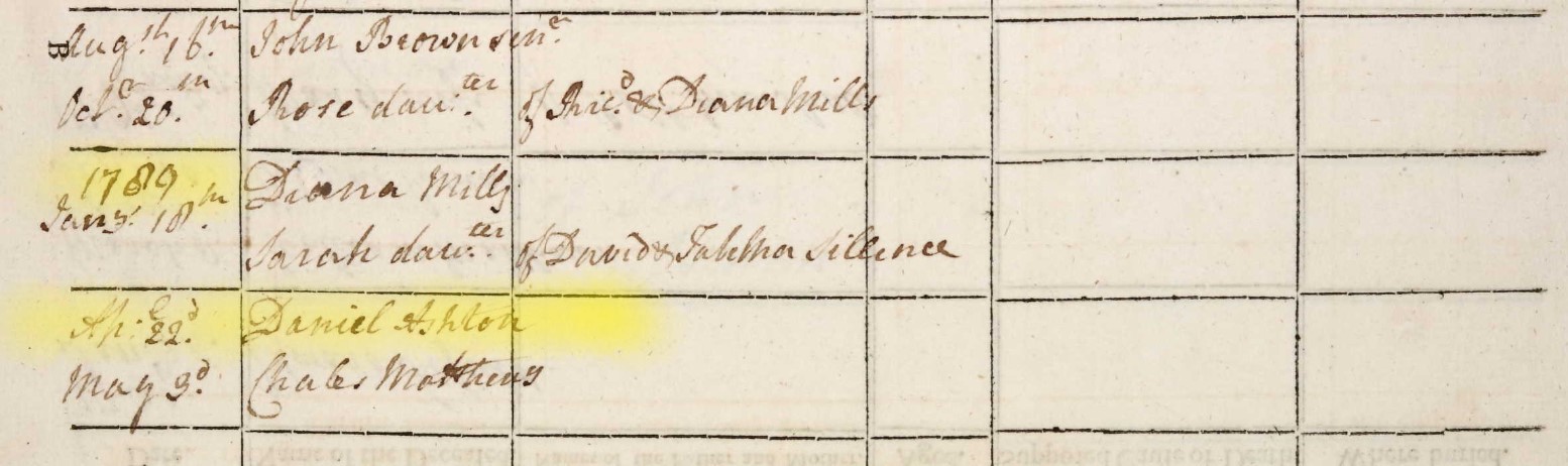
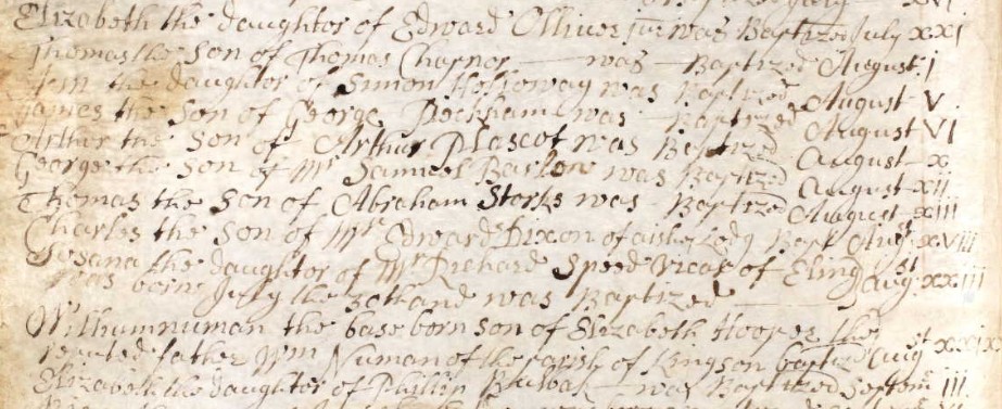
- Census
- One Place Study
- Domesday Book
- Tithe Map
- Standbridge
- Freemantle
- Shirley
- Oakley Road, Freemantle, Southampton
- Act of Parliament
- Tithe Apportionment and Map
- British Library
- Taylor's 1759 Map of Hampshire
- Map of Hampshire Thomas Milne, 1791
- Ordnance Survey
- Hampshire Advertiser
- ESRI StoryMaps
- British History Online
- County of Southampton
- National Library of Scotland
- Census Enumerator
- Church of England Map of Parishes
- National Archives
- Parish of Millbrook
- Guild of One-Name Studies
- Enumerators route
- ARCGIS Mapping
- georeferenced maps
- Grid Reference Finder
- Latitude Longitude
- Latitude
- Longitude
- tollhouses
- Census Districts
- Southampton and Salisbury Canal Company
- enclosure map of Hill and Shirley
- Whimpston
- Wimpston
- Wimpson
- Doswell
- Hill Lane
- Cockerwood House
- Sotonopedia
- Whithedswood Common
- Shirley Common
- Warren
- Hill
- Whiterswood Common
- Cock Road
- Shirley House
- Redbridge
- Foundry Road
- Manor of Shirley
- Shirley and Hill
- Whitehead family
- Alexander Thistlethwayte
- Norman Court, West West Tytherley, Hampshire
- West Indian plantation owner
- Richard Wilson
- Shirley Park Road
- Reverend Sir Charles Rich
- William Henry Roe
- Mayors of Southampton
- Southampton
- Whitehead
- THE COUNTRY HOUSES OF SOUTHAMPTON By JESSICA VALE
- Hampshire Field Club and Archaeological Society
- Baronetage of Great Britain
- Dictionary of National Biography
- Mulberton, Norfolk
- Hampshire Records Office
- Nursling Manor
- Robert Rich
- Nathaniel Rich
- English Civil War
- New Model Army
- English path to democracy
- Fifield
- William Edward Humby
- 1 Rose Hill Cottages, Romsey Road, Old Shirley, Millbrook
- Freemantle Local History Group
- Cedar Lodge House
- Mousehole Lane
- Mussoorie Villa
- Richard Garrett Oakley
- J Jarrett Esq
- Freemantle Park
- Whiteheads Wood
- agricultural and industrial revolutions
- agricultural revolution
- industrial revolution
- Nursling
- Nhutscelle
- Hnutscilling
- Nutshullyng
- Romsey Road
- Hollybrook Stream
- Tanner's Brook stream
- Winchester Road
- Lordswood
- Vaux Hall
- Four Posts
- Grove Place
- Hundred of Mansbridge
- Ralph of Mortimer
- Cypping
- Cypping (of Worthy)
- Nathaniel Newman Jefferys
- Church Building Society
- William Hinves
- FIELD SYSTEMS AND ENCLOSURES IN HAMPSHIRE
- Wolsey's Commission
- Depopulation Act of 1536
- County Agricultural Survey
- first industrial society
- first urban society
- urbanisation of the countryside
- Tithe Commutation Act 1836
- Freemantle Estate
- Banister Estate
- Lady Hewitt
- Reverend William Fitzhugh
- Blightmont Lodge
- Lady Lisle
- Millbrook Road
- Berrywood Estate
- Clement Hoare
- William Dunn
- Warren Avenue
- Warren Crescent
- Tremona Road
- Greenwood's Hampshire 1826
- Google Earth
- Project in Google Earth
- The Parish of Millbrook Tithe Apportionment
Tithe Apportionment - Parish of Millbrook, Hampshire
Note the reference to Depopulation and read more about it here. By 1530 the population of England and Wales had risen to around 3 million. At the end of the 17th century it was estimated the population of England and Wales was about 5 1/2 million. The population of Scotland was about 1 million. The population of London was about 600,000. London went on to become the biggest city in the world for a while. In the 19th century Britain became the world's first industrial society. It also became the first urban society. By 1851 more than half the population lived in towns. As our population approaches 70m it is interesting to think of depopulation efforts at 3 million! The maps of Millbrook clearly show the urbanisation of the countryside.
Following the Tithe Commutation Act 1836 Tithe Maps were produced which recorded both the Landowner and Occupier for most lands. From the Tithe Apportionments records it is apparent that on 4th March 1843 Lady Hewitt was both the Landowner and Occupier of Plot 875, Freemantle Estate, described as House Offices and Pleasure Grounds, with an area in statute measure 6,0,2, about 2.4 Hectares.
Nathaniel Newman Jefferys was both Landowner and Occupier of Plot 825 described as House Offices and Garden, an area of 2,2,24 imperial, on 4th March 1843. However, one plot does not show the full picture.
 Pepin the Short's father, was Charles Martel.