My Travelogue |
Tales of my first time
|
Pakistan to Nepal |
A collection of stories about my years of overland travel, holidays and short breaks, around the world.
This is the story of my first overland trip, Trans Asia 1975.
On page notes and credits
Photo Galleries;- There are no direct photo galleries for this page. Most photos enlarge in a new window when clicked. The photo links frequently open a new site in a new window, Change window to return here.
Status; Under development, active page. Bulk of stories complete, Sidebar started,
To do list; Key dates and timeline. Finalise sidebar Proof read to do.
This page last updated:
Pakistan, India and into Nepal
The Indian Sub-continent
We had arrived. Not only Asia, but the Indian Sub-continent. The home of the East India Company. India as it was before separation. Part of the British Empire, as was, so driving on the left again.
The map below shows this part of the journey.
View Trans Asia 1975 - Pakistan to Nepal in a larger map
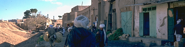
Pakistan
Continuing where I left off, from the previous page.
The Khyber Pass
The Khyber Pass is a brilliant road. Or at least it was in 1975. A real drivers road, with a view. And what a view.
View Trans Asia 1975 - Khyber Pass in a larger map
A close up map showing railway zig zag, the new road and the old road
View Trans Asia 1975 - Khyber Pass in a larger map
Mountains soring all around to above 1600m. Deep gorges, and a river cascading along the valley floor. Add a blue sky, and a touch of warmth. What could be better? I recognise that the Irainian mountain pass summit at 2440m is higher than the peaks in the Khyber Pass, and the scenery there was wonderful, but perhaps the Khyber Pass is just more dramatic, or its reputation enhances the experience.
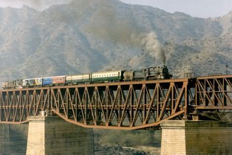
Above is a map of the Kyhber Pass, with the current road shown in blue. I have also tried to trace the railway in brown. However, some times the digital imagery is not clear enough to locate the railway. The railway was built by the British after the 1914-18 war. The railway was officially opened on 3 November 1925 during the British Raj in India and and is called the Grand Trunk Railway. It runs from Peshawar to Landi Kotal, and on to the Afghan Border. An amazing feat of engineering, weaving back and forth, and in and out of numerous tunnels. One of the great railway journeys of the world.[1>]
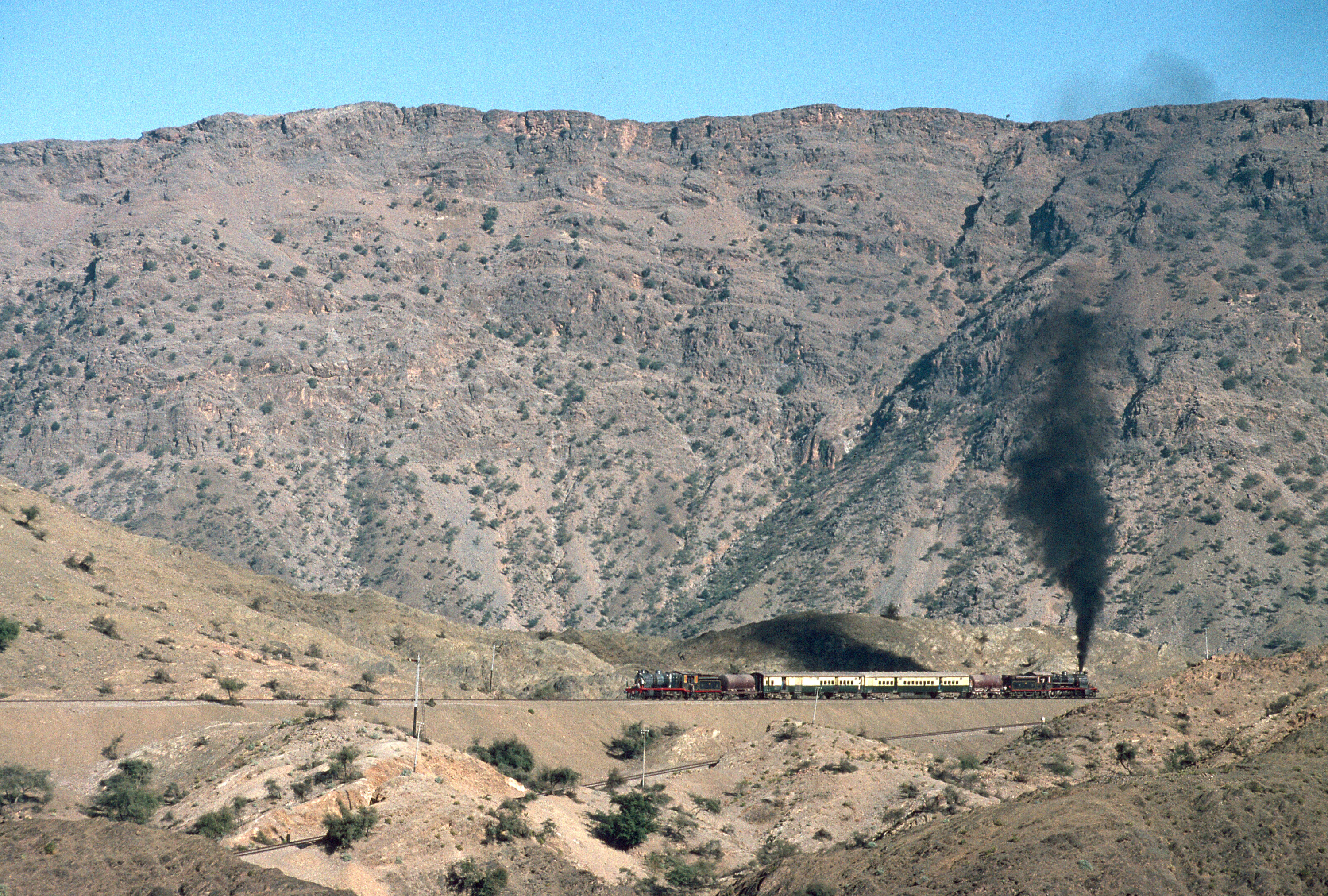
The Khyber train safari had been described as "a journey into time and history." [2>] The photo of the train taken in December 1993 was found here, with the caption; The Khyber Railway. With a Pakistan Railways HGS 2-8-0 at front and rear a charter train climbs the Khyber Pass through a series of zig-zags to gain height.
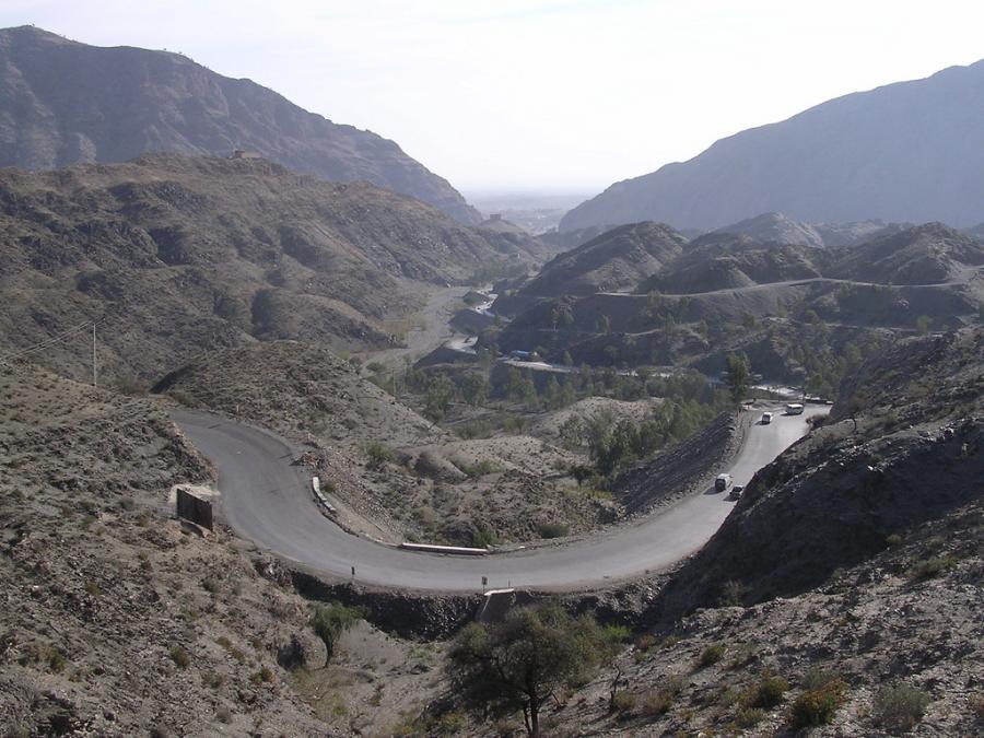
The road is almost as spectacular, zig-zag up and up
The road is almost as spectacular, zig-zag up and up. Hairpin bends, one after another, on a steep climb. Then down again.
Zoom into the map, and be amazed. Change to satellite view and see, in places individual trucks on the road. You can still make out the old road in most places. From my inspection of the map it appears that the route has been subject to a huge amount of roadworks.
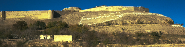
It is not just the scenery and the zig-zag road which makes this area. There are a lot of guns and forts. As soon as you enter a village you will see locals with a rifle slung across his back, or even more readily available. Houses are built within a compound. Your own mini castle.
Have a look at this more recent tale about a visit to the Khyber Pass.
The following image was found at Learning Team 4-3
The caption reads; The Khyber Pass today is used mainly for transportation. There are two highways- one for motor vehicles, the other for traditional caravans- as well as a railway winding through the pass. It was used to deliver arms to Afghanistan and to transport refugees from the Afghan civil war into Pakistan.
I don't recall two roads so I imagine the road described as 'for traditional caravans' was the original road, the one I travelled on, before the new road was built. I remember mixed traffic consisting of heavily laden brightly painted trucks, barely moving in some cases, buses, with people on the roof, as well as the odd animal, hurtling along at breakneck pace, animals being herded form one place to another, and people walking. Such a mix of vehicles and speeds led to problems, which unfortunately were occasionally catastrophic. The road shown looks a lot safer, at least in terms of the driving.
The area was described as lawless. Hence, don't stop, and all the forts. However, other reports tell of how enthusiastically hospitable the locals can be. We were not able to test that as we were so late getting into the pass due to the check point incident. In fact, we did not have time to savor the breathtaking scenery we were driving through. Concentrating on staying on the road, getting round the bends, and not hitting anything, which thankfully, we achieved.
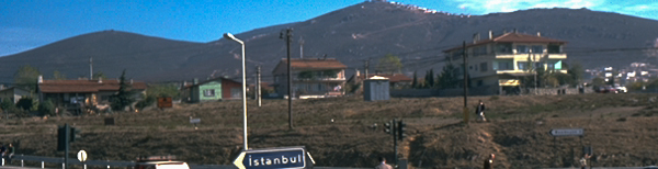
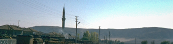
Peshawar
We left the Khyber Pass and were quickly on the outskirts of Peshawar.
It was getting dark. But it was still hot. Up until now the heat of the day was extremely hot, but bearable as it was dry heat. As soon as the sun went down, the temperature plummeted, and in some locations was notably cold. High altitude obviously increased the effect. But not here it was still hot and humid. One of the affects of driving in sunny climates is you get truck drivers elbow. Our truck was the normal English right hand drive, so the steering wheel was on the right and accordingly both our right elbows were effected. It is not something people suffer these days as adverse effects are known about. Then it was OK. What is drivers elbow? Wikipedia talks about nerve being compressed or "pinched", and often time caused by resting or bracing the elbow on the arm rest of vehicles over extended periods of time. The truck does not have an arm rest, but it does have a window which when wound down provides an ideal arm rest. Exactly the right height. Result, right elbow gets more exposure than any other part of the body. This memory was prompted by [3]. The elbow was as dark as the locals walking through the pass. The rest was not far behind. Often the dress code whilst driving in remote areas was a pair of shorts and little else. In populated areas, more respect for the locals, and their culture, more clothes. Why tell you about it here? Because within a fortnight of being in the humid climate, it was as if we just needed a good wash. We were several shades of brown lighter.
Back to, it was getting dark. We had been given an address of a Dak Bungalow as a place to park up over night. [4>] Eventually we found it. It was past its best and a bit ramshackle, but it met our needs. We stayed a few days.
stepping out was like stepping into a hot oven.
One evening we got dressed up and went to a posh restaurant. Not the sort of place we would normally go to, but it is nice to treat oneself every now and again. We went in and sat down. It was freezing. We looked around, considered leaving and then noticed the three truck refrigerators on the back wall. You know the type, behind the cab, on the front of the box trailer, keeping the contents chilled or frozen. This was their version of air conditioning. We became accustomed to the cold, and then it became normal. We could read the menu, and talk to the waiters. The meal was excellent. We took our time and enjoyed it, no need to rush. It was late when we left. Darkness had fallen. We thought it was a bit strange that four waiters were set to wish us a good night. Two opened the inner doors, and closed them behind us, then two opened the outer doors, airlock style. That's when we realised what was happening. We had become so acclimatised to the air-conditioning, which was very confortable, and conducive to staying, that stepping out was like stepping into a hot oven. The heat and humidity just hit us in the face. Wow, that was extreme. We stood for a while, then slowly walked back to the truck. It was after midnight by the time we got back to the truck. Unlocked the back and flung open the shutter and windows. You don't leave anything open, even slightly ajar. Back into another oven. We stripped off and changed into shorts. Others at the Dak were still up and we ended up entertaining. Even the candles appeared to be adding too much to the temperature in the back of the truck. We talked into the morning. The stifling heat did not abate much during the night. But it was good to be able to entertain.
they both presented arms, in unison,
The next day we walked to the railway station. Not quite sure why. As we got there, and had started to look around to buy a platform ticket, we heard a train coming. Over the entrance to the platforms, a sign 'No entrance without a ticket' in English, was reinforced by a soldier each side of the entrance with a rifle. The sound of the train was closer and was immediately identifiable as a steam hauled train. We did not know if it was due to stop. No time for further investigation. we did not want to miss it. So we approached the guards, to ask if we could just look. Before we spoke they both presented arms, in unison, not out of place at Buckingham Place. We took that as a yes, and walked onto the platform. The steam engine pulled in, and the platform erupted into life. Food and drink sold to passengers on the train, through the windows. Some passengers would leave the train to walk the platform, always accosted by vendors of something. Or they would buy a meal from one of the many stalls. Passengers leaving would perhaps pick up a porter to carry their luggage. It was acceptable and expected not to carry your own luggage, even for a short distance.
Another day we went shopping. It was a corner shop, absolutely heaving, not quite out the door but up to it. It was like the shops we had in England, before self service became the way. There were counters with different products, and people who served you behind the counters, with a smile. We used to have that in England, but people became too expensive, so we had checkouts, but now we are doing away with those as well. Shops without people soon, all in the name of efficiency. Shame about the out of work and broken society. Back to the shop, and all the hustle and bustle. We could not make out a queue at first or what was sold at each counter. Then to our great surprise a shopkeeper arrived at our side and asked us, in accented but good English, what it was that we wished to purchase. We tried to indicate that other people were in front of us. That was dismissed with derision. We were experiencing the caste system in action, alive and well. White and English was high caste. In some areas it was equivalent to Brahmin. This gave us certain privileges, but also obligations. We learnt as fast as we could. Understanding and adopting culture is important.
We parted with our new found friends from the Dak Bungalow and set off towards Lahore.
 Talking
of artics later on this page has made me recall a
bridge, over a river. It was a truss bridge with two decks, one
for railway and the other for road traffic. Unusual, but not totally
unheard of. It had something of a inherent problem though. At least
one end was a right angle bend. Too tight for the artic to get
around in one sweep. That meant they had to shunt backwards and
forwards to get under the railway and aligned up with the bridge.
Across the river, and then the same. A bit of a traffic jam. It is
now called the Old Attock Bridge and it crosses the Indus.
Talking
of artics later on this page has made me recall a
bridge, over a river. It was a truss bridge with two decks, one
for railway and the other for road traffic. Unusual, but not totally
unheard of. It had something of a inherent problem though. At least
one end was a right angle bend. Too tight for the artic to get
around in one sweep. That meant they had to shunt backwards and
forwards to get under the railway and aligned up with the bridge.
Across the river, and then the same. A bit of a traffic jam. It is
now called the Old Attock Bridge and it crosses the Indus.
 The
double header photo by Malcolm Peakman appears in a
wonderful article about the rail road bridge and describes its strategic importance and history.
It also details how and why the original needed strengthening. The Attock Railway Bridge opened for traffic on 24th May 1883.
Amidst the photos on the site, one shows the fortified entrance to the bridge in 1905, as well as the state of unpaved Grand Trunk Road (now highway N5) which used the lower level of the bridge. You can see how much of a tight entrance it is for road traffic, onto the bridge.
The
double header photo by Malcolm Peakman appears in a
wonderful article about the rail road bridge and describes its strategic importance and history.
It also details how and why the original needed strengthening. The Attock Railway Bridge opened for traffic on 24th May 1883.
Amidst the photos on the site, one shows the fortified entrance to the bridge in 1905, as well as the state of unpaved Grand Trunk Road (now highway N5) which used the lower level of the bridge. You can see how much of a tight entrance it is for road traffic, onto the bridge.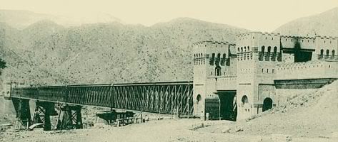 The photo is copied here in black and white. Comparison between the
photos shows the extent of the strengthening works. It hardly looks
like the same bridge. The reconstructed bridge was opened on 30th August 1929. It carries a single broad gauge line.
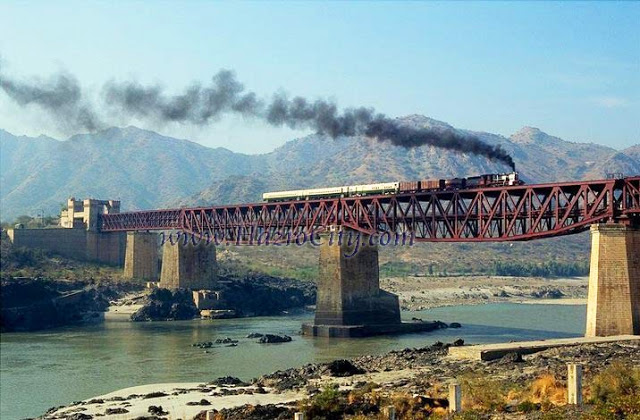
Another source of photos of the
Old Attock Bridge. Whilst digging around for information about
this bridge I also found a website
about the area from which I copied the photo with the single
header train, which is annotated
HarzroCity.com, another local area website.
The photo is copied here in black and white. Comparison between the
photos shows the extent of the strengthening works. It hardly looks
like the same bridge. The reconstructed bridge was opened on 30th August 1929. It carries a single broad gauge line.
Another source of photos of the
Old Attock Bridge. Whilst digging around for information about
this bridge I also found a website
about the area from which I copied the photo with the single
header train, which is annotated
HarzroCity.com, another local area website.
We stopped of at Rawalpindi and watched a little cricket. Not only on the greens, but any dirt patch will do for kids to strike up a match. It is not a surprise that they became so good at the game. We watched cricket and had lunch. No alcohol of course, driving, and Pakistan is a dry country.
 Next stop,
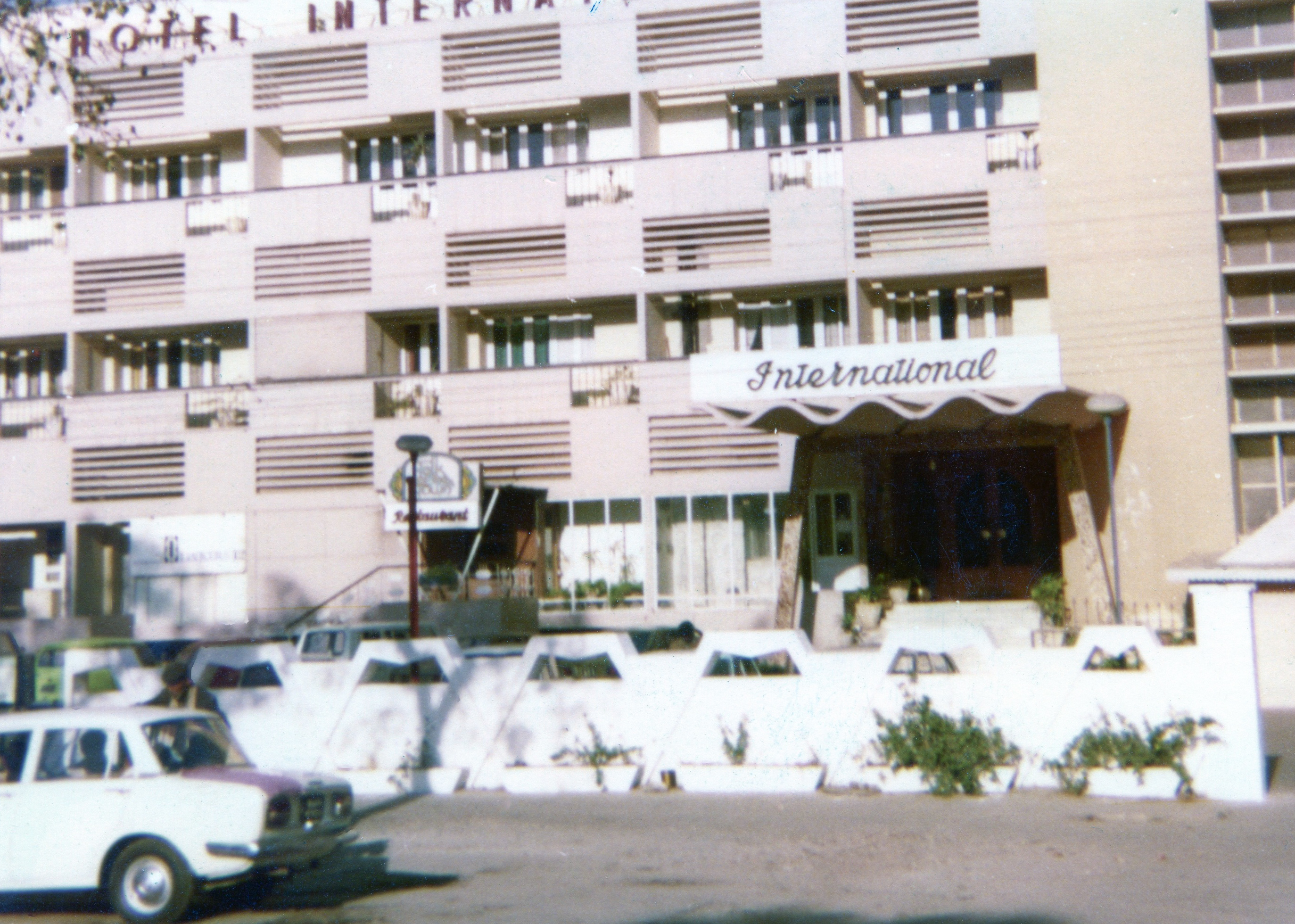
Lahore, and another treat. See the photo, one of the
very rare ones we have of the time, taken by somebody we met on our
travels. We stayed at the Hotel International. We were not
planning staying long, just a cool nights sleep. It had air
conditioning, or so it was claimed.
Next stop,
Lahore, and another treat. See the photo, one of the
very rare ones we have of the time, taken by somebody we met on our
travels. We stayed at the Hotel International. We were not
planning staying long, just a cool nights sleep. It had air
conditioning, or so it was claimed.
Was there a plane in the room?!
Up to the room, turn the air-con on before eating. Back to the room still fairly warm. Air conditioning seemed to be more about a ceiling mounted fan. We tried to get the room cooler, as Lahore was even more stiflingly hot than Peshawar. We turned the knob on the air conditioning, all the way round to maximum. Was there a plane in the room?! Must have been. No, apparently not. Just the ceiling mounted fan, gradually building up speed, until, with a small amount of asymmetric spin and wobble the fan tried to destroy itself and fly into a corner of the room with pieces of ceiling quickly following behind. That was the right speed to cool the room.
We spent the night, with one or the other of us waking up being too hot, turning the fan up, not getting to sleep again because of the noise, and turning the fan back down again. There was no happy median. The fan was fairly ineffectual at anything apart from the top speed and worryingly off balance and noisy at top speed. It never did come off though. We complained and were given another room, which was slightly less disturbing, even if not any cooler. We only stayed one night.
Lahore is a massive, crowded, busy city. But can I remember much about it? Unfortunately not. A big railway station, but was that the second trip?
Whilst in Lahore we were approached by some locals, or more precisely, people who appeared to be locals. They had a proposition. We take our truck to their garage, and leave it there for three days. They would pay for our hotel. Then, once we had successfully crossed the boarder into "India, we again would leave it in another garage". For this they would pay $6000, part up-front, the remainder upon delivery. When questioned, they assured us, it was not drugs!
We did not take up their offer. Kind as it was!
We left Lahore, for the boarder.
'The impressive and unique flag ceremony at the Wagah Border Crossing between Pakistan and India'
India
The flag ceremony again, but from the Indian side. It takes a lot of collaboration and coordination to be able to put on such an impressive show on a daily basis. We did not see it unfortunately but wanted to share it with you, the reader. There are many other clips on YouTube.
It is said that the British gave India railways and the civil service. If we gave them the civil service, and not the other way around, they have adopted it with a passion. An example. At the border we had to complete entry cards. This is not unusual, I hear you say. You would be right, but not six separate times. No carbon paper or self coping paper. One of the copies was meant to get to your point of exit before you did. {As part of the Taj Mahal history it appears that India had a civil service under Akbar the Great (14 October 1542 – 27 October 1605), he was the third Mughal Emperor.}
They knew we had drugs!
Immigration done, customs next. They had been tipped off! They knew we had drugs! They searched the truck top to bottom. Everywhere. We had jerry cans roped to the inside of the chassis. They wanted to cut the ropes, but we made them wait while we untied the ropes and brought them out from under the truck. Eventually they gave up. Then they started to talk. Told us they had been tipped off about this particular truck, including the registration. In turn we told them about the offer of the garage. Then it was all smiles. The believed us and understood. We had not done what the drug gang had wanted, hence the spiteful tipoff. Frequently happens apparently. They accepted we did not have any drugs, and allowed us to repack the truck. Several hours later we were on our way, not best pleased with the unwarranted incursion and delay.
But hey, we were in India.
Unfortunately this did not put us in the best frame of mind for Amritsar, which we kind of skipped past, regrettably. We went to see The Golden Temple [5>] but did not stay long enough to enjoy it and look round. I think it was also a case of not knowing if we would be welcome or not. (Quick reminder, this was before mass tourism to the area).
It was about this time that we started to travel with other people. The truck had the standard three seats in the cab, although that would be cozy, especially for long distances. In the back we had fixed two twin sets of coach seats onto a raised platform. We had acquired opening front windows from a scrap yard and had installed them to look out above the cab. Add side windows and it was a good place to sit and watch the world go by. We also installed an intercom between the back and the cab. Throw in some curtains for the night time and you have a home. One of the things we did not think of before leaving Hatfield was what would happen with the windows open. The curtains attacked anyone sat in the coach seats with a zeal. Fortunately, that was an easy fix on the road, using rope to create heavy duty tie-backs. Most things we put in were over designed.
I don't recall advertising for additional travellers, nor to I recall a specific name, but as I recount the next story I have a feeling the there were more people than just Pete and I.
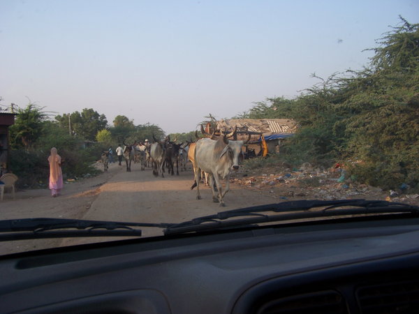
headlights alone do not resolve the impenetrable dark of a rural Indian road.
We stopped just before dusk and just pulled of to the side of the road. Despite it being the main intercontinental road there was little traffic at night. There is a good reason for this. It is dangerous. Very dangerous. The road may have been metaled / surfaced as a two lane road at some time in the past. Now, with the edges warn and broken away it was a central strip one and a half trucks wide. The edges were dirt and potholed, some very large potholes. If you were rash enough to drive at night, it the countryside, all manner of things could pop out of the dark to scare you. Headlights do help, and I now understand the intercontinental trucks with a full width rack of lights atop the cap, but headlights alone do not resolve the impenetrable dark of a rural Indian road. An overloaded oxen hauled cart just jumps out in front of you with no by your leave. No lights, no reflectors, nothing, to give any advance warning, it just looms out of the dark, one very large dark mass travelling at maybe as much as 3mph, against your 30mph or more. The closing time is scary. Collision imminent. You have to leave the road, but which way. The cart is pulled by one or more oxen, so will keep to the best part of the road to reduce the strain on the animals. Either side, outside the beam of the headlights, is pitch dark? Is there a bike there? Another cart, this time coming towards you? Some people walking between villages? Which side? The brakes bite, and you come to a stop with inches to spare. Just don't do it. It is dangerous.
the whole village had arrived to look into the back of the truck
We pulled off to the side of the road, well away from any communities. Dusk became night. It was still hot so we were cooking with the shutter fully up, and the lights on in the back. A weathered man turned up on his bike, got off and just stood looking into the back of the truck. We tried to strike up a conversation, offered some sweets, something to eat, or drink maybe. No contact. No interaction. After a while he left. My recollection is that there were at least three of us that night, but, with apologies to whomsoever, I have no idea who the other person was. We said how weird it was that nothing we tried worked. Normally something does. Then it got weirder. He returned with somebody on his crossbar. They stood and looked. then he left, leaving the other guy on his own looking into the back of the truck in amazement. This happened again, and again. It continued in the same pattern for a while, until it felt that the whole village had arrived to look into the back of the truck, including children. Even the children would not take sweets. It was as if we were aliens from another world and they were looking into our spaceship. It was getting late. Still no meaningful communication. We had eaten, washed up, and it was time for bed. Then, they all turned around and walked back to the village. No shuttling on the crossbar to return. After all said and done, they knew what they were retuning to. It was only a hurry to get to see the spaceship. To be fair, thinking about the situation, let me try to compare it to planes. Normal, scheduled or charter airplane with hundreds of people all crammed in together. Abnormal, jumbo jet as private airplane, with only three people on board. In that context, I would also be a bit gob smacked. Our truck was a little bigger that most of theirs, just to add extra emphasis.
On another night, at a different location, somebody wanted to put his five sheep in the back, and take him and them to market in the next town. He wanted to pay us. Not a freebee. He was perplexed and confused when we declined. It was evident that any other truck would have been keen to have the income. We tried to explain that it was our home, not for goods. He walked them to market. The good thing was we had managed to communicate, after a fashion, which was a significant improvement on the night of the village.
We also learnt that we could not always rely on directions. Even simple ones like which way is Delhi. The tendency is for the rural locals to not know where Delhi is and to assume that you know best. This translates to whichever way the truck is pointed is the way you want to go. Slightly infuriating if you don't know which way to go. But hey, it is nice to always be right!
We made regular progress towards Delhi, our next big milestone. Then I became ill. Very week, dehydrated, vivid green pee. I just laid in the back and Pete did all the driving. Salt was missing. Our diet did not contain enough salt. Pete took a salt tablet and washed it down with coke. Very amusing to see him foaming at the mouth until he was sick. Another lesson. We were learning a lot. Boil the kettle. Pour the water into a tin mug, and let it cool. (it does not have to be a tin mug, its just that is what we had.) When it is cool enough to drink easily add one teaspoon of ordinary salt, and give it a good stir. Have a taste, if it does not taste very salty add some more salt, but no more than two teaspoonful's. Then drink it down. The more the body needs the salt, the less it notices the taste.
Delhi
We arrived in Delhi.
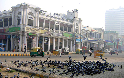
It was crowded, would be something of an understatement. It was heaving.
Traffic everywhere. People everywhere. I don't recall how many people were attached to the truck by then. We parked the truck up in a campsite and left it there for the duration of our stay, apart from our trip to Connaught Square.
We were terrorised by a journey to the a government house in a tuk-tuk. I am sure the drivers have a death wish, taking on any size of vehicle and continually weaving in and out of the traffic, changing lanes, going through gaps that just did not exist, talking all the way. In 2011 a friend went on the rickshaw run, a charity event across India. I have an image in my mind as to where the driver dropped us of, the shape of the gates but not a clear image yet of the building. So I don't know if we went to the Red Fort, or Rashtrapati Bhavan, or any of the other government buildings, including the British High Commission.
There were far more beggars in Delhi than any other place we had been to. Professional beggars. There was one guy who would arrive at his pitch early in the morning, settle himself down on the pavement, expose the end of his stump, and then prep it for the day, including a liberal dose of red sauce. It looked raw and painful when he had finished. I hope he made extra money because of it.
the crowds, the whole of humanity in one place
We met more fellow travelers in Delhi and got to know some locals. We parked in the centre of Connaught Square on some days. The square seems to become the centre of the universe, and the crowds, the whole of humanity in one place. Half of them wanting to sell you something. Not really, but sometimes it felt like that.
I think it must have been a festival of some sort because lots of pranks were being played. Somewhere on the journey we encountered Holi Festival, but I don't think it was Delhi, Perhaps not even this trip.
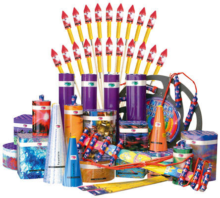
Indians seemed to love fireworks. Perhaps it was the festival, perhaps it was normal. In England it was still mainly restricted to 5th November celebrations. Now it is any excuse. However, there size matters! Safety, less so. A banger may take your hand off, if misused. One of the pranks was to place a firework in the traffic. The aim was to have a vehicle drive over it, without hitting it, at the right time. Preferably a bus. A firework going off under a bus full of maybe one hundred people.[6>] Ah, I hear you say, the passengers would hardly hear it with the noise of the engine and the hubbub of all of those people, crushed together. True, but this was no ordinary firework. It was deafeningly loud, and lifted the back of the bus off the ground. (Almost) When the timing was right. Obviously, the world has changed and you just would not, could not, do that today. The consequences are unthinkable.
Not quite sack cloth and ashes, but not far off. He was a Baba
On our way into Delhi we had decided to give a lift to a local. He was a priest. Not quite sack cloth and ashes, but not far off. He was a Baba, and seemed to like being called Baba. He had no possessions and no money. He decided to cook for us all in Delhi. We had by then acquired quite a gathering, not all travelling in the truck, but linked to it whilst we were parked up at the campsite. We went to the market with him to buy the food. That was our mistake. He had no need for money. He asked for ladies fingers, and he was given them, willingly, with a smile. He would bless the giver, and move on. Never asking for a lot. Just a little, but from a lot of traders. I assume he told them about us, and what he was doing. He collected food for about 15, and not a rupee, nor a paisa, changed hands. That's when we realised how revered he was in his community. He cooked that afternoon, ready for an evening meal. There was a large group coming so we were planning to eat outside. The time came, our mini crowd arrived. Problem. Only Baba, Pete, and I could eat it. It was so hot that the others bottled out and ate elsewhere. All the more for us. A veritable feast. Well, not a feast actually, as it was simple food, as you would expect from a Baba, well cooked. Like a stew, but with a kick, and what a kick.
The next day he thanked us for the ride, we thanked him for the food, and he left, smiles all around.
One thing I have not said yet is that we tried to learn a little of the language of each country that we stayed in for more than a few days. How to count to ten and maybe ten common words like thank you, please, Namaste.
I have been referring to Delhi, but it is properly called New Delhi. We went to Old Delhi one day. I understand why they built New Delhi. Old Delhi is even more crowded, with smaller, narrower streets. I don't think it was very pleasant. Back to New Delhi quickly.
 I
am now confused. As I write this my memory tells me we went to Connaught
Square [7>] and parked the truck in the middle, on hard ground, probably
tarmac, or something similar. One thing I try to do as I write up my
experiences is try to validate as much of a memory as I can with the
facts around it. Frequently Google Maps is the first source of that
validation. This time however, it was not so obliging. There is a Connaught
but it is
Connaught
Place, New Delhi, India. A circle not a square. First thought is
that it has changed. Roads do, such as the Khyber Pass. But no, it
is easily established that it was built in the 1920s. Perhaps it was
just a part of Connaught Place that I remember, as may be suggested
by the photos which I
found here and
here. Or perhaps it was somewhere else altogether.
I
am now confused. As I write this my memory tells me we went to Connaught
Square [7>] and parked the truck in the middle, on hard ground, probably
tarmac, or something similar. One thing I try to do as I write up my
experiences is try to validate as much of a memory as I can with the
facts around it. Frequently Google Maps is the first source of that
validation. This time however, it was not so obliging. There is a Connaught
but it is
Connaught
Place, New Delhi, India. A circle not a square. First thought is
that it has changed. Roads do, such as the Khyber Pass. But no, it
is easily established that it was built in the 1920s. Perhaps it was
just a part of Connaught Place that I remember, as may be suggested
by the photos which I
found here and
here. Or perhaps it was somewhere else altogether.
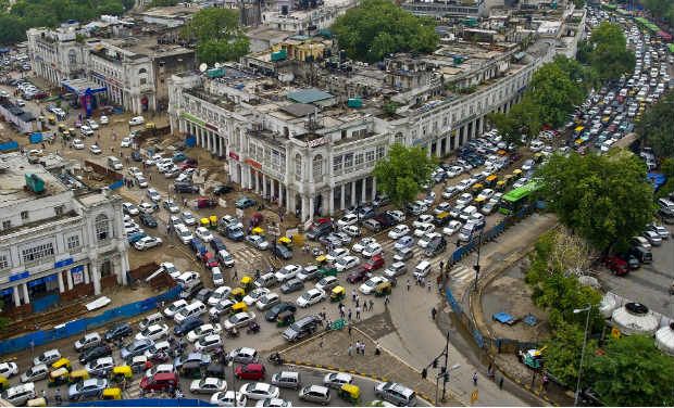 Wherever it was it was absolutely heaving. it was a mass of moving people,
rickshaws, tuk-tuks, taxis , cars, buses, with the occasional truck
and few cows thrown in for good measure.
Wherever it was it was absolutely heaving. it was a mass of moving people,
rickshaws, tuk-tuks, taxis , cars, buses, with the occasional truck
and few cows thrown in for good measure.
The Taxis were mainly black and yellow Morris Oxfords.[8>]
We danced in the rain beside the truck
It was hot, very hot. Ah, a refreshing breath of air, then another. Where had all the people gone? How can that many people disappear in less than a minute. They were going indoors, any indoors. Anywhere to take shelter. And then it started. We ran to the truck. It rained. And I don't mean a light drizzle, perhaps as a prelude to a heavy shower. It was heavy rain, very heavy rain. We danced in the rain beside the truck. It must have been a strange sight. This was only the second day that it had rained since leaving England. Then we accepted the inevitable, and took shelter in the truck. We were literally soaked through to the skin. Dripping on the floor, a puddle quickly appeared. Off came the wet clothes, on with the shorts. Then watch the deluge through the windows. The noise was intense as the rain hammered on the top and sides of the truck. Despite the drains the road soon disappeared. The water filled between the kerbs. Nothing moved except water. It kept falling, and quickly toped the kerbs. The edge of the road had disappeared, and the river that replaced the road was becoming a lake. The shore was getting close to the truck, then we were surrounded. It was still raining, and the waters still rising. Then the rain stopped, as quickly as it started. The flood waters ebbed away. The people returned, as did the traffic. Normality was returned, but a cleaner, sweeter smelling normal. The monsoon had arrived. That was the first day of the monsoon, it was late. Well that was fun!
There are more stories about Delhi, I will come back to them.
Enough of Delhi, back on the road, the GTR, Grand Trunk Road.
Agra
Agra next stop. And what a stop. The Taj Mahal [9>] totally deserves the hype. It is beautiful, and we spent a good time looking around. We also went to the Red Fort [10>]. The Red Fort was the home of the builder of the Taj Mahal. Both are now UNESCO World Heritage sites. Compared to the Taj Mahal, it was empty. We had free reign to wander at will. Having been a residence, as opposed to a mausoleum, it was a much more complicated structure, and hence more interesting. Not as beautiful, but more to see. I particularly remember wandering around and area of high walls laid out as a grid of rectangles, within a rectangle. We found the sign. It explained that it was a complicated water storage and management system. It was all dry, but you could spend the time and follow the guide to work out how it all functioned together. We were there, in the water tanks, all on our own. Apart from the ever present monkeys of course. They inhabited the place, humans were just transient visitors. The monkeys could become quite aggressive, especially when they feel they have the upper hand. We spent a while longer looking around the Red Fort.
We should have gone down to Jaipur next but we did not know that, no guide books to tell us, and it was not on the route of the GTR. A pity. we heard about it from somebody we met. I am not sure where we met him, but the story can live here.
He showed us his passport stated that he was a photographer. He explained that the whole trip was tax deductible as a professional photographer. He looked forward to discussing his taxi fairs in Jaipur with the tax man back home in England. Nothing wrong or illegal, just the expression on the tax mans face. Elephant taxis. To this day I have not been on an elephant taxi. Apparently we missed out big time by not going. He was still with us in Kathmandu as he took the photo of our truck there. His name is ... [11>]
Agra to Gorakhpur
Navigation in India, along the GTR is simple. Drive for 1000miles and turn left at Gorakhpur, then drive to the hills.
On the way we did check directions from time to time. Always, the way the truck was pointing. However, on one occasion a pleasant surprise. We were invited to drink tea in his garden. We gracefully declined, he insisted, so we accepted. We walked to his back garden and had a very relaxing tea and sandwiches on the lawn with his family. Very refreshing.
Sometimes we would stop at a roadside chia cart. We were becoming more confortable with eating and drinking from roadside stalls. Not because we thought they were any safer, just that we hoped that our stomachs had become more accustomed, more resilient. Roadside tea is interestingly different. It is in a urn or large pot, continually heated and kept hot. Milk and sugar are already added. It is wet, warm, sweet and very refreshing, even if different to our normal English way of making Indian tea.
We came to a fork in the road, right Grand Trunk Road and on the Banaras, aka Varanasi, left, towards Lucknow, the regional capital. We chose left. Missed out on a visit to Banaras, a very important Hindu location. It is holiest of the seven sacred cities. [12>]
Very quickly we came to a bridge, that just kept going and going, and going. The bridge was a lot longer than the river was wide at the time but it looked as if it was quite capable of filling its banks, and more, from the evidence of flooding. We were across the Ganges. The most important river in Hindu terms, and the one flowing through Banaras.
 I found this photo at
indiamike.com. It gives some idea of some of the roads. Not
always with so many people and animals, especially away from
villages.
I found this photo at
indiamike.com. It gives some idea of some of the roads. Not
always with so many people and animals, especially away from
villages.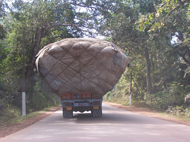 In the second photo the metaled part of the road is wider but with
loads like this, it is still a challenge. Both photos are by
vinathorat.
In the second photo the metaled part of the road is wider but with
loads like this, it is still a challenge. Both photos are by
vinathorat.
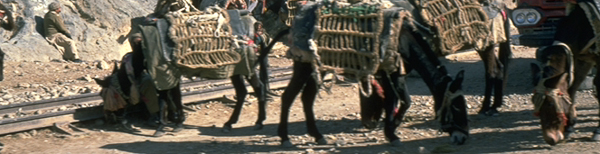
I can't remember exactly where we saw this. Road building. I spoke earlier about the dirt roads being repaired by a grader. In India they have a different technique. They rebuild roads using trucks which resemble tipper lorries, but have either lost the tipping ability, or never had it. An other alterative is that they just don't use it for some reason. Frequently the source of the material is the dry river bank or bed. This is hand dug and loaded into the trucks. Sometimes they will have a digger but generally it is done by people with shovels. The truck drives to the road worksite and stops in the traffic. Another group of people unload the lorry, again with shovels. Then a bigger group of people, including women and children get to work on the ungraded aggregate material. If there is a large rock, a group of men will break it with rock chisels and 14lb sledge hammers. They will move to the next one of the same sort of size, leaving their work to be continued by another group of men, but with rock chisels and 7lb sledge hammers. The rocks get smaller as do the hammers and the people wielding the hammers, until it is women and children, squatting down, creating the aggregate of the required size, with 1lb or 8oz hammers. No rock crusher and sieve machines here to provide graded and angular ballast. There are lots of people. They all need jobs, earnings, something to eat. No need to replace them with expensive to buy, expensive to run machines.
Flash your headlights first and you have right of way
I haven't told you about another driving technique yet. As the roads became more rural, understandably they were less maintained. It seemed as if the road edges of a two lane road had warn away until there was barely one lane left. Obviously with only one lane for two directions there is something of a conflict. To overtake slow moving traffic you have to persuade them to leave the relatively smooth blacktop for the dirt edges, or do so yourself. At least the road used to be that wide and being a plain, does not have the issue of falling off the side and down a mountain. But that is the easy bit, what about oncoming traffic. A couple of rules. Flash your headlights first and you have right of way. Generally works. The other, play chicken. Keep driving at the same speed alone the single blacktop lane. Closing, closing, and then swerve off to the left. As long a both of you do this you miss the side of each others truck by inches. The dirt part of the road can be quite potholed making for a rough landing at speed. You also have to be vary aware of anything, or anyone else already on the dirt. Personally, I prefer the headlight method.
At one place, I don't know where, possibly on the way to Lucknow, we were on one of those single lane roads and there in front of us, coming towards us, was an official cavalcade, with police outriders and everything. I quickly flashed my headlights. I did not expect to win that one. I fully expected one or two of the bikes to race towards me and send me off onto the dirt. But that did not happen, the whole of the cavalcade left the road, onto the dirt, and allowed me, and my big truck, to stay on the blacktopped part of the road. Sweet. Oh, and as we were no longer on a international trade route type road, and the articulated trucks were nowhere to be seen, we were back as being big.
Talking of artics has made me recall a bridge, again, location unknown. It was a truss bridge with two decks, one for railway and the other for road traffic. Unusual, but not totally unheard of. It had something of a inherent problem though. At least one end was a right angle bend. Too tight for the artic to get around in one sweep. That meant they had to shunt backwards and forwards to get under the railway and aligned up with the bridge. Across the river, and then maybe the same. A bit of a traffic jam. Ah found it, Old Attock Bridge [13>] [In case you missed it, jump back to the article]
Through Lucknow and on towards Gorakhpur. Just as we approach Gorakhpur we cross another large river, the Rapti or West Rapti River. Ultimately, a tributary of the Ganges. At Gorakhpur we really did need to turn left. On the right road, only one of many. It took a while to find the correct left turn, but we did eventually, and set off North in hope. There were no road signs despite it being the main road into Nepal from this part on India. [14>]
Another interesting building technique, at least if you are in the construction industry, as I am. We had seen plenty of buildings with scaffolding around them. The scaffolding was not straight metal poles clipped together to a careful space frame design, analysed and checked, then platforms created with scaffold boards and toe boards. Bamboo poles lashed together with rope. Not a vertical or straight pole to be seen. The whole structure looked ready to collapse. Occasionally braced with some scrap timber, maybe it swayed too much before. Long pole ladders provided access for a concrete pour, at height. We would use a concrete pump for a pour that high now. Not for them. Hundreds of people, each with a flat basket carried on his head. One ladder up, full, and another ladder down, with an empty basket. Not a lot of concrete carried in each one, but use enough and the pour moves forward faster than the concrete sets, which is as much as you need.
Then the last leg north to the boarder. No horror stories, nor any special ceremonies.
A relatively easy crossing on both sides, just a few queues and a bit slow. As expected.
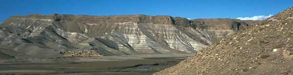
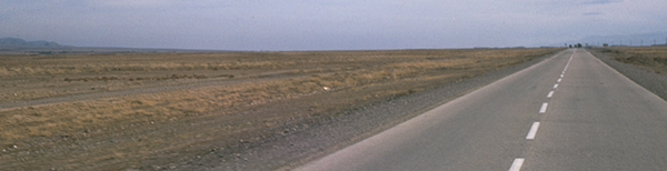
The Ganges plain stretches to the boarder and beyond.
Nepal
Some nice photos to start with and a story about cycling in the area.
Then we are into the Himalayas
After about 30km the plain gives way to the hills. The last town is Butwar, on the northern edge of the Terai plain below the Siwalik Hills. Then we are into the Himalayas. The wide valley closes in on the town, until there is only room for the road and the river, and little else. Reminiscent of the Khyber Pass.
Himalayas
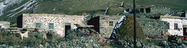
Small shrines and temples are an abundant addition along the roadside. Sometimes where there has been an accident, but far from always. This temple is called Siddhababa and it is at the very outskirts of the town, at the beginning of the foothills of the Himalayas.
As we enter the foothills of the Himalayas the road is blocked by a wooden pole across the road like a car park barrier. We have to get out, show our passports and fill in a register type book. We find out later that the road abounds with these little check points. They explained that they were for our safety. So many people counted into a section, and so many counted out. If they match, another successful day. If not, has somebody got lost or fallen off the edge of the road, down the mountain. I assume for the latter scenario they mount a search and rescue mission. This photo may be of about the area of the check points. It also shows the valley, our first into the low Himalayas. Another photo or two shows the river in the bottom of the valley.
I think I should explain what is happening here. I use Google Maps to help with remembering the route. Sometimes with photos turned on. This in turn links to Panoramio with a tag line of 'Share and explore the world in photos.' The photos linked to the map are geo-located and Panoramio helpfully offers more photos of the same area. I would have loved to have taken some of them and be able to enhance this story with contemporary images of my own. That is not the case so I use other peoples photos to aid your (the reader's) visualization. However, if the photos are not for general use I provide a link to the public location of the photo, as intended by the photo author. Each such photo opens on a new page so that you can continue to read without losing your place. With Nepal being such a wonderful place, so photogenic, there are many photos to choose from. On with the story.
View Trans Asia 1975 - Pakistan to Nepal in a larger map
Somehow, here and there, small farms and villages squeeze in as well. Communities are joined across the river by delicate rope suspension bridges. People only. I found this photo of a bridge a little lower in the valley. In this photo it looks as if the bridge has been replaced, compared to some I have seen, this one is in good condition. This photo is apparently one of the three suspension bridges in the area of the map leading to the village of Dobhan or Dovan
I can see exactly how close the tyres are to the edge of the road
The climb truly begins. Already above 500m. The hairpin bends start as the road meanders into side valleys, still climbing. The valley floor, and river is now over 100m below, on the right. It is nicer to drive when the valley is on the right as I can see exactly how close the tyres are to the edge of the road, especially as we navigate some of the bends.
The odd village hangs on to the side of the mountain, still in amongst the trees at this elevation.
Shortly after, the terracing of the mountainside begins. It can be seen by satellite on Google Maps. This is just the beginning of the Himalayas. Farms in England, or on plains, tend to be flat or thereabouts, with fairly big fields. As the hills get steeper the farming changes to animals, with the steep bits reserved for sheep. But the very steep, out of the way places are no longer farmed.
In the foothills of the Himalayas there are some large flat valleys but mostly, it is, not surprisingly, hilly. If you want to have a flat field, you have to carve it out of the mountainside, in narrow strips. So that is exactly what they do. One layer at a time. I don't know if they go down the mountainside or up, or even both, but somehow they create a landscape from the mountainside that they can grow crops on, to sustain life. No tractors, some of the strips are too narrow, and most are inaccessible. It is either animal or people who provide the power to run such farms. An amazing resilience. [15>]
View Trans Asia 1975 - Pakistan to Nepal in a larger map
There is a photo of this village showing the road, homes, and truck typical of the low Himalayas.
Waterfalls off the mountains provide drinking water, somewhere to meet and play, and somewhere to wash. {That reminds me of another story, but it belongs in the Trans Asia 1977 trip}. Waterfalls also damage the road and sometimes wash it away altogether. Landslides are difficult to repair in the Himalayas. We are on the main cross Nepal road and it is generally metaled, although most of the other roads appear to be dirt.
View Trans Asia 1975 - Pakistan to Nepal in a larger map
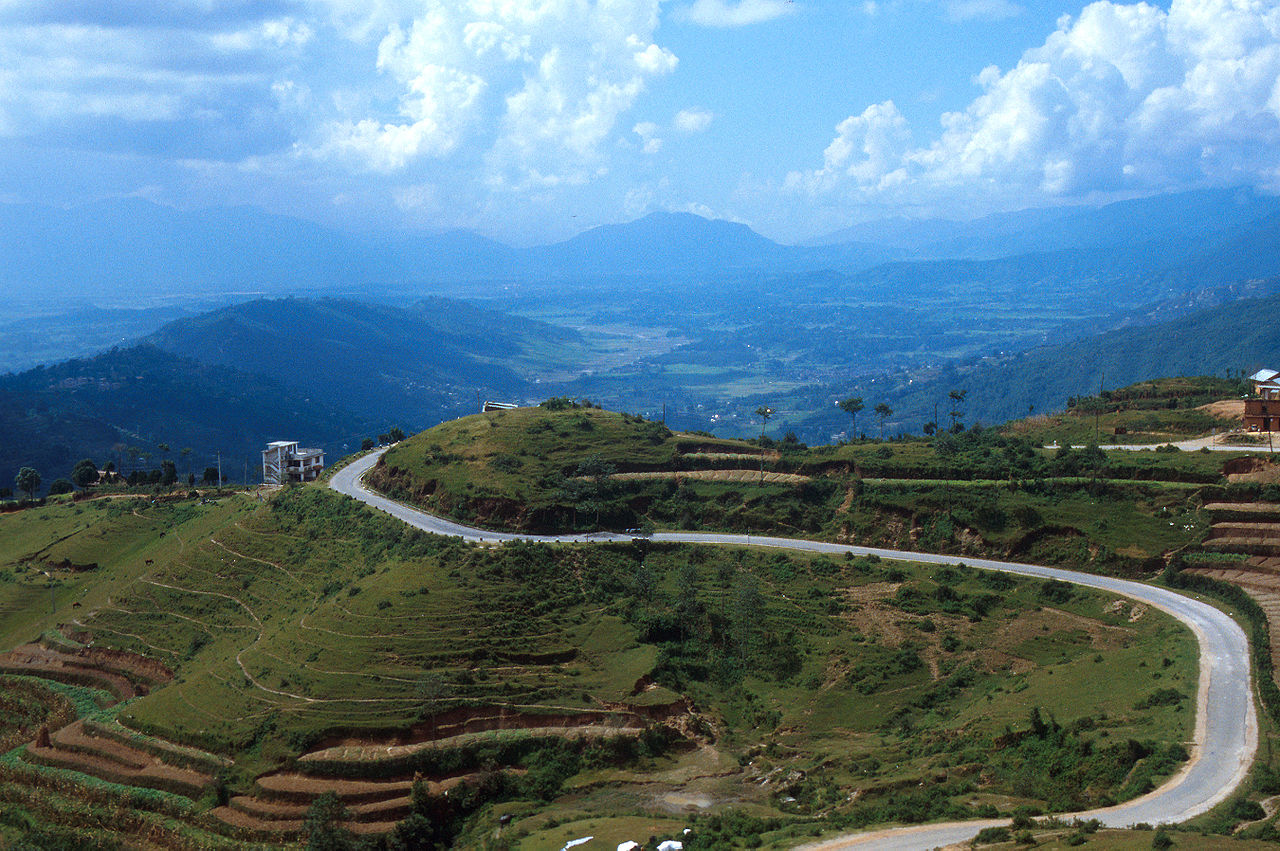
An interesting shape. The road to Tansen winding tightly like a F1 race track apart from the 400m increase in altitude from 1200m. Even more terracing in this image.
Tansen
 A view of Tansen by Adawahee
We stayed the night in Tansen town square which is now the Bus park. Thinking about it there were quite a few busses parked there then. We had been through the police check point to complete that leg of the journey. Our first town in Nepal. Here are a few photos around town and near the chowk. (the last two photo links are by Sunmaya, follow the link to find lots of good images around Nepal.) We ate out that evening. Unfortunately it did not sit well. Now, when you are travelling one of the main subjects of conversation when you meet a fellow traveller is about toilet, in graphic detail sometimes. I will not subject you to that level of detail. Suffice to say I had to leave the truck several times during the night. Plain rice is a good calmer for the stomach, a good stopper. Then back on the road again.
'It is better to get there ten minutes late than not get there at all'
As with the Khyber Pass, traffic is very mixed with extreme speed differentials. There is even a scheduled bus service. The drivers evidently know the road very, very well, or they drive with reckless abandon. These are dangerous roads, not as bad as some shown in the link, but dangerous all the same. The government tries to instill a degree of caution with road signs such as 'It is better to get there ten minutes late than not get there at all' Or something to that effect.
We continued to weave our way along the mountainous road, taking in the sites as much as possible, whilst keeping on the road and avoiding other traffic. We stopped at the check points and dutifully signed in. The villages, or more properly hamlets, nestled on the mountainside, and although evidently very poor, were picture postcard material.
There was a lot less hassle in the mountains than the plains, less begging, and less 'you want mister'. Not just a difference between India and Nepal, but between plains and mountain people.
Pokhara
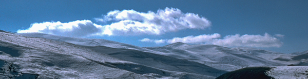
The 'Himalayas' had been hiding on purpose
We arrived in Pokhara and found a hotel. Looking at Google Maps, wow, hasn't it grown. We stayed at a small hotel with a large garden. The hotel staff where happy and helpful. The view was not as spectacular as we had hoped. Generally, even when driving along the roads hugging the mountainside, there was a lowish cloud cover. Not fog, but not clear blue skies either. You know where I am going with this. One morning the clouds were not there, just for a while. The 'Himalayas' had been hiding on purpose. There, just there was Machhapuchhre, standing tall, overshadowing us, in all its glory, part of the Annapurna range. The superlatives are insufficient. I will find a photo from my next trip. An unforgettable view of dawn breaking over the peak of the sacred Fishtail Mountain: Macchapucchare. What a treat. All too soon the clouds wrapped their blanket around the the peaks and the mountains went into hiding again. A good disappearing act.
The King was still on the throne then, and still revered as a god. He had a palace in Pokhara which we visited, but just the outside. We were not allowed in.
The lake was also nearby, so clear and peaceful.
Pokhara, such a wonderful place, but time to move on again.
More checkpoints to sign in and out of. Not a problem, as the more you drive along these roads, the more you can understand the reason for having them. Too many people don't get to sign out.
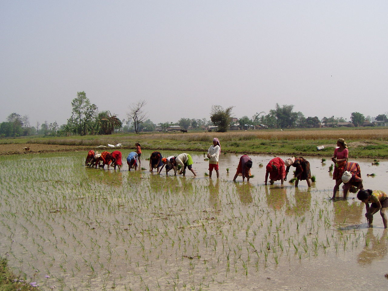
It is amazing how the locals manage to eke out a living in these mountains. A cluster of small shacks make up a community living of a hostile landscape. Mountainsides are tamed by endless terracing to create small fields, which are tended by hand. Back breaking work. Rice is an important crop. Considering that rice is grown in water, generally in low flat valleys, it takes extreme ingenuity to grow it on a mountainside. [16>] Surprisingly I saw some of the farmers using the khukuri knives, famously used by Gurkha soldiers, as a all purpose farming knife. Maybe the story that a khukuri knife is never put back in its sheath by a Gurkha without drawing blood, is not true.
Gurkhas come from many areas and tribes in Nepal [17>] and here we are driving through one of those areas. I don't think it looked any different, apart form I seem to recall a sign to that effect.
There was a story doing the rounds about a
small village in this area,
which goes something like this;
A wealthy American dropped his
wallet in the street of a small village. He was on this way to
Kathmandu before he realised it had gone.
A local person found
the wallet and looked inside, it contained hundreds of dollars in
cash, more than a years wages. He took it to the police. The police
checked the contents, made enquiries, found out from the checkpoint
registers that the owner had gone towards Kathmandu, The cash alone
was more than the police annual wage, then there were the credit
cards, The owner had gone, never to be seen again. He could
obviously afford to lose such a sum, and still travel to Kathmandu.
The police sent the lost wallet on to the police in Kathmandu. Again
the police checked the contents, and made enquiries. Located in a
hotel, the American was reunited with his lost wallet, totally
intact.
As this story was circulating in Kathmandu, it presumably came from the
American in question.
The whole story is a testament to the honesty and honor of Nepalese hill people. There are plenty of places around the world were the outcome
would have been different. Where even giving the wallet to the
police would not have a positive result. Nepal was amongst the
poorest countries of the world
Two maps of the same place showing side by side the satellite image and terrain map of excellent examples of true zig zag roads on both sides of the valley with the main road. But have a look at the photos on this site for a real scare. [18>]
View Trans Asia 1975 - Pakistan to Nepal in a larger map
View Trans Asia 1975 - Pakistan to Nepal in a larger map
One thing that has been something of a surprise as we approach Kathmandu is the lack of high passes. As I have said before, it is very difficult to research trips like this before the internet, and before a wealth of guide books, covering almost everywhere, with all conceivable forms of transport, with the possible exception of elephant taxis. We are driving along the spine road of the country, West to East, in the Himalayas, and so far we have barely hit 1500m in altitude. That is a lot less than the mountain pass between the Caspian Sea and Eastern Iran which peaked at 2440m. Having said that, this is a much more interesting, exciting, and pretty road. The road hugs the valley sides winding its way through the Himalayas, only reluctantly climbing trough high passes where absolutely necessary. The road meanders in and out of side valleys and zig zags up and down the mountainsides. We have seen so many signs attempting to get drivers to drive carefully that we have lost count of the different phrases.
View Trans Asia 1975 - Pakistan to Nepal in a larger map
The map shows a marker which appears to be around the highest altitude of a road near Kathmandu at about 2150m, or a shade over 7000ft. A little closer to Kathmandu and the road zig zags back down again, loosing over 400m within this map. However, I am not sure that we took either of these roads. Google Maps currently shows a more direct route at a lower altitude, but I don't know when it was built. There is a dam for Marsyangdi Hydropower Station which I don't recall and was apparently commissioned in 1989. It is possible that a new road, in whole or in part, was built for the construction of the dam.
View Trans Asia 1975 - Pakistan to Nepal in a larger map
Think of this. Driving along a road in the countryside in England on a sunny, warm day, fields on either side. Crops in their full glory, a field of rapeseed in full blossom, the landscape turned vivid yellow. Breath in deeply to feel the countryside. Wait that is a different smell. We were driving through a small sunny valley approaching Katmandu and on our right was a whole field of Cannabis plants, ripe with a distinctive smell. Growing cannabis on a farming scale. Apparently honey from bees in the area is sold as 'special' honey, which is know to have peculiar side effects, or maybe, not side but main! Who would have thought it, hash growing openly by the side of the main road. Anyone could stop and take a little, its not as if it was guarded. In reality it was not illegal to grow the plant at the time so there was no need to hide it away, and there was little more threat of theft than any other crop. In fact possibly less given how poor the country and is people were, food was higher on their want list than drugs.
We crept round a bend with one of those twin wheels hanging over the edge of the road
Irrespective of which actual route we took for the final approach to Kathmandu, I do recall some tight hairpin bends and difficult roads which provided a little extra adrenalin. Here I was glad we had the truck that we did, with twin wheels on the rear axle, or six wheels on two axles. On a number of occasions, too frequently, we crept round a bend with one of those twin wheels hanging over the edge of the road. And that does not mean, off the metaled road, onto dirt, but off the road into fresh air, with a significant drop from the mountainside down to the valley below. It is not a pleasant thought, even less so with a super single. They are bigger, wider tyres which replace twin wheels with one. The 4x4 Bedford has four wheels on two axles.
Kathmandu
We arrived in Kathmandu, a large valley. I say valley, but at 1400m, c. 4,600ft it is higher than any mountain in Britain. Another different world.
We had been given the address of Kathmandu Guest House as somewhere to park the truck and rest our heads. It was not easy to find, off the main road, down very narrow alleys. We found it. Oh no, the entrance was blocked by an overland truck trying to navigate the right angle bend in the, touch the sides, lane, and the gates of the hotel. We watched for a while, then did much the same thing with the hotel next door, The Hotel Star. And that is where we met Santa. ...
Read more of our stay in Kathmandu, and how we became rich.
Perhaps a final overview of Nepal from Ganesh Thapa and some YouTube video of a selection of dangerous roads. Not the roads we traveled on. There is a truck caught on camera going over the edge. The traffic jam that beats the M25, following a landslide, and many more, just for your edification. On one, where we see the bus almost hitting the face wall, and then reversing, to get round the many hairpin bends, just cast a thought, as the driver selects reverse and hangs the passengers at the back of the bus over the edge of the precipice, and the back wheels get closer and closer. Enjoy!
To see more clips, click here.
The page opens in a new window. I moved the clips because they made the page too slow. Be patient as the page loads, the clips are worth it.
Enough scary road trips.
The road we took was obviously in better condition than those, even so you can appreciate that driving and taking video at the same time might be difficult, and not without hazard.
Itinerary
Key Dates
| Pakistan | ??/??/1975 to ??/?? |
| India | ??/??/1975 to ??/?? |
| Nepal | ??/??/1975 to ??/?? |
Timeline
| Pakistan | |
| Peshawar | |
| Rawalpindi | |
| Lahore | |
| India | |
| Amritsar | |
| New Delhi | |
| Agra | |
| Lucknow | |
| Gorakhpur | |
| Nepal | |
| Tansen | |
| Pockera | |
| Kathmandu |
Pakistan
local map insert here
Pakistan starts with the Khyber Pass. Not a bad introduction with splendid scenery.
I did not take a camera on this trip, film only at the time, no digital, which obviously results in no photos of my own. However a trawl of the internet provided me with the following links.
Links to other peoples photos of the Khyber Pass
[1] Some photos taken by George Woods of the Khyber Pass Railway in 1978. Wonderful Photos of the day.
SGS 2471 en route Kyber Pass 10.3.78
SGS 2471 en route Kyber Pass 10.3.78
SGS 2386 Shahgai Water stop 10.3.78
SGS 2386 Medanak Reversal 10.3.78
SGS 2471 en route Kyber Pass 10.3.78
More photos;
Khyber Pass - view to Pakistan
Khyber Gate Information Plaque #1
Khyber Gate Information Plaque #2
[2] The Khyber train safari had been described as "a journey into time and history." The train consisted of 1 parlour car and 2 second class coaches pulled by two vintage steam locomotives that took tourists through breathtaking and rugged mountainous terrain. The train covered a total of 52 kilometres (32 mi) through 34 tunnels and 92 bridges and culverts. The 1920s model vintage oil-fired steam engines, which pushed and pulled the carriages from the rear and front, were built by Vulcan Foundry and by Kitson & Co in the United Kingdom. The steam safari climbed more than 1,200 m (3,900 ft) to reach Landi Kotal.
The railway was closed in 2006 after a flood washed away railway track and bridges.
[3] Another Wendy Tanner photo of her taking tea, Mazar-i-sharif, and some of the comments reminded me of this snippet.
Oh my god you're almost as brown as him!! Had you not heard of sunscreen in those days or could you just not buy it on your hippy pilgrimmage :)
I'll probably pay for it later!! "Back in those days" (now I'm really sounding old) there wasn't the awareness of skin cancer like there is now ...and besides...I'm sure there would have been no sunblock for sale at the souk in Mazar!!!
From my recollection Dak Bungalows were a relic of the Raj. A place where visiting government officials could stay for a short while before continuing their journey. The official could have been an inspector, auditor, diplomat, or manager. Seniority obviously mattered thought. The bungalows were spacious, luxurious and would have made for a very pleasant stay. There were plenty of servants all the time, as you did not know who might arrive. Better to have more servants, ones you could trust to do there job well, than have to go out finding additional staff because a party from Delhi had just arrived.
This is all supposition, I have yet to read confirmation.
Although the one we stayed at was fairly run down at the time it was easy to see that it could have been quite splendid in its day.
India
Map of India
View Trans Asia 1975 - India in a larger map
Then a bit closer, just North India
View Trans Asia 1975 - India in a larger map
[5] Golden Temple
Insert GT here
New Delhi
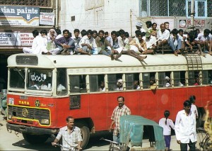
[6] Photo of bus full of people. This is not an example of the buses at the time in Delhi, but it does give an idea. It is made by Tata, which is correct for the time. I suspect that local buses in Delhi do not normally have as many passengers on the roof.
 s
s
I found the image on the internet. Click on the image to find out where.
[7] Map of Connaught Place {Square}
View Trans Asia 1975 - Delhi in a larger map
[8] Morris Oxford Taxis
In 1957 all the tooling of the British Morris Oxford Series III was transferred to India. The car was renamed the Ambassador and series-production started in 1957.
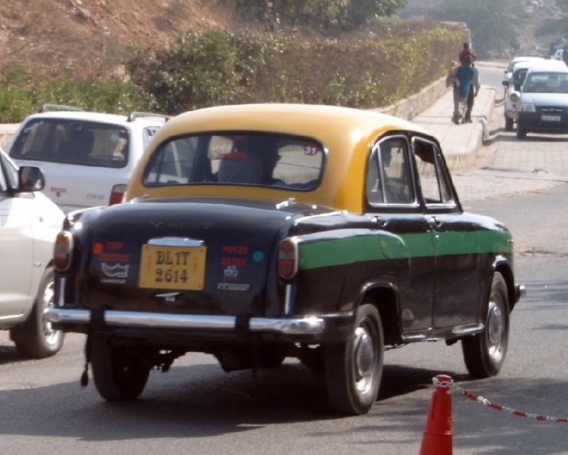
Photo link and a front view.
The Amby, as it is affectionately called, has been in continuous production since its inception, with very few improvements or changes. In 1948, Hindustan Motors shifted its assembly plant from Port Okha in Gujarat to Uttarpara in West Bengal's Hooghly district and strengthened its manufacturing capacity in the automobile segment.
India abandons the Hindustan Ambassador over terror fears
[9] Taj Mahal is a splendid mausoleum build by a Mogul king for this third wife.
 Taj Mahal by Amal Mongia.
Author's note: "january 06-early morning- taken with lubitel-expired ektachrome slide film expired-cross processed. it is NOT photoshopped."
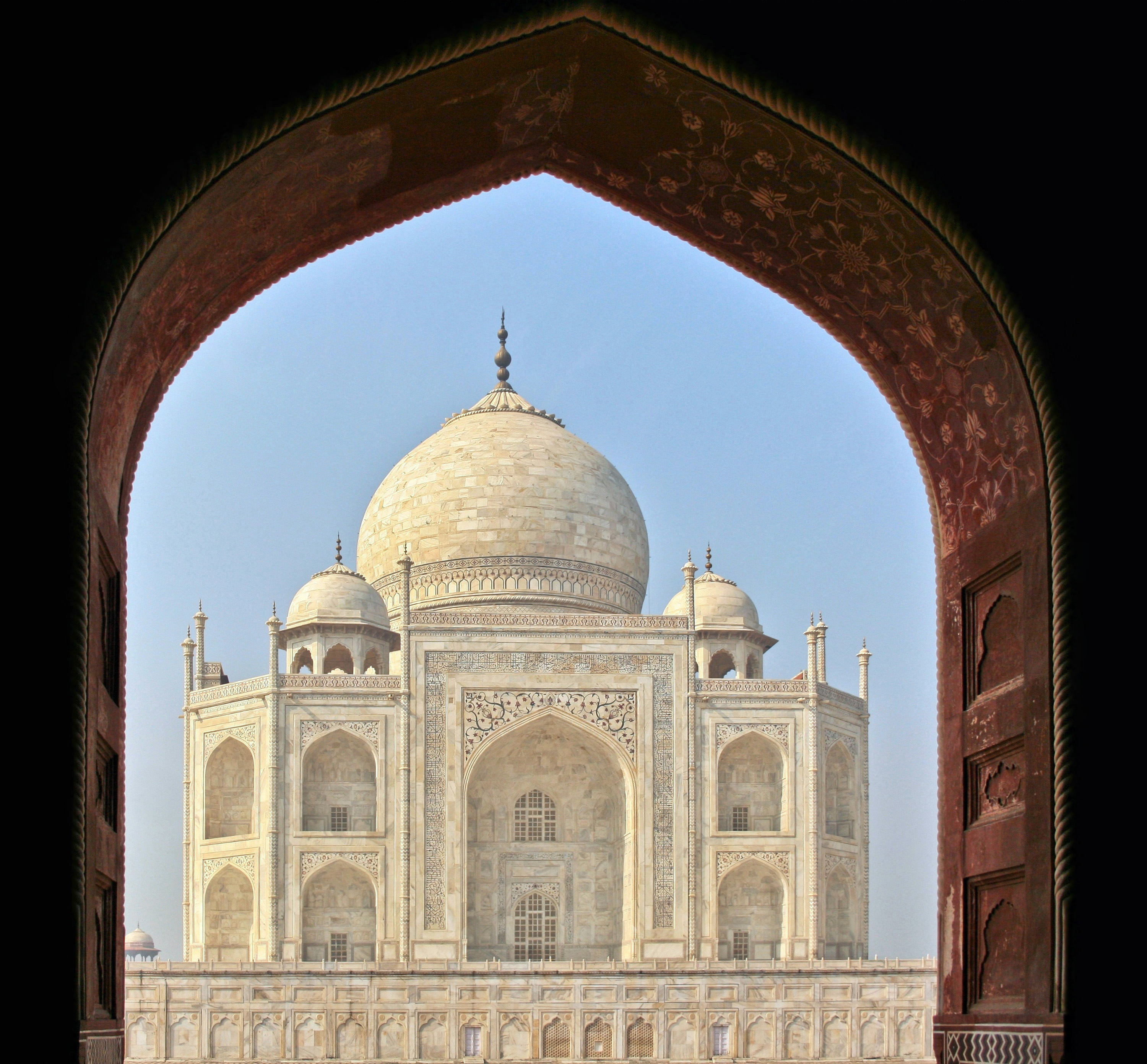
Taj Mahal, Agra by Diego Delso
A rare photo without people in it.
Visit the Taj Mahal government web site for more photos and information.
For a view of the Taj Mahal from Agra Fort look at this photo by Kostan
Agra Fort inscription Uttar Pradesh, Agra by Matthew Laird Acred
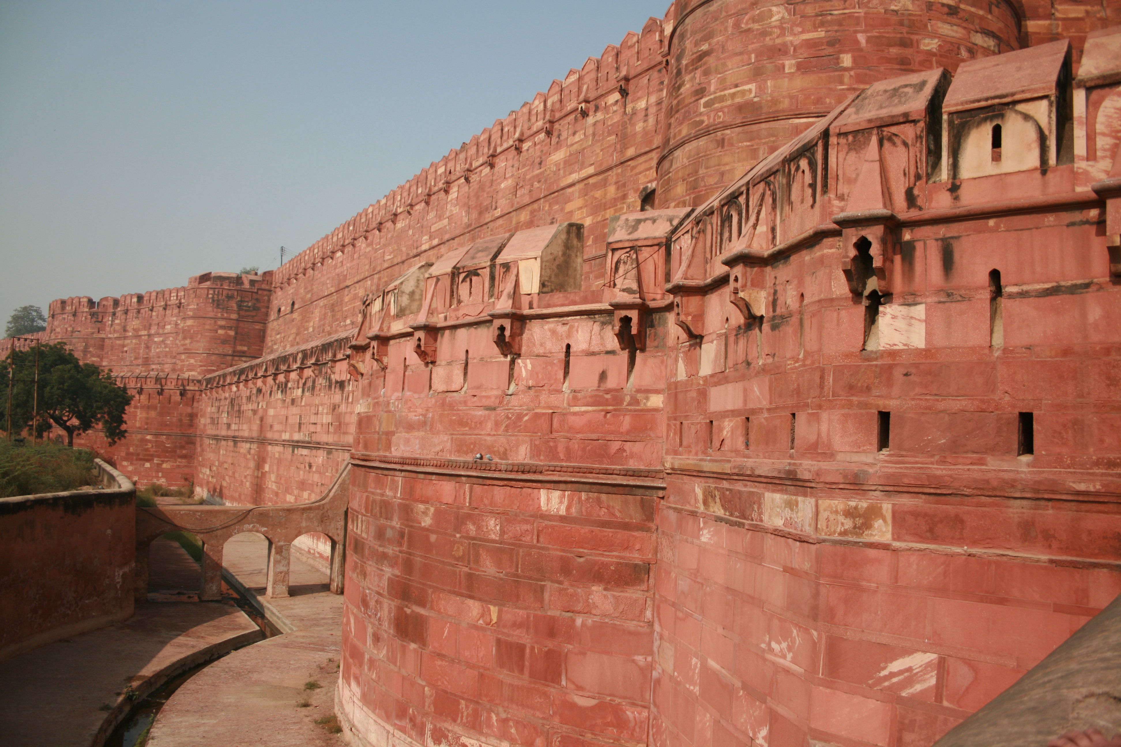
Gates and Walls, Red Fort, Agra by Diego Delso
Follow the link architectural sojourn of Agra Fort
[11] His name is Martyn Dean, and when he was not
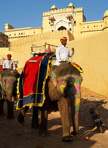 {Elephant taxi, Amber Fort (Jaipur) By Evgeni Zotov} riding on the back of elephant taxis in Jaipur and travelling
the world as a professional photographer, he was travelling the
world with
Yes. His brother is more well known, being
Roger Dean.
{Elephant taxi, Amber Fort (Jaipur) By Evgeni Zotov} riding on the back of elephant taxis in Jaipur and travelling
the world as a professional photographer, he was travelling the
world with
Yes. His brother is more well known, being
Roger Dean.
 Roger
is the artist responsible for this Yes cover and many other
brilliant and iconic album covers. An extract from
Roger's bio states; 'With brother Martyn, designed stage set for Yes United States tour'
in 1975. Roger and Martyn did many other things together including
Roger
is the artist responsible for this Yes cover and many other
brilliant and iconic album covers. An extract from
Roger's bio states; 'With brother Martyn, designed stage set for Yes United States tour'
in 1975. Roger and Martyn did many other things together including
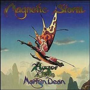 writing
the book Magnetic Storm. It was this Martyn Dean that we met
somewhere in India or Nepal after his 1975 tour with Yes. He was
definitely with us in Kathmandu because he took a photo of our truck
there and gave us a print. For the avoidance of any doubt
whatsoever, all of the above three images are credited to either
Roger or Martyn Dean, or both. I recognise their rights and seek
their indulgence.
writing
the book Magnetic Storm. It was this Martyn Dean that we met
somewhere in India or Nepal after his 1975 tour with Yes. He was
definitely with us in Kathmandu because he took a photo of our truck
there and gave us a print. For the avoidance of any doubt
whatsoever, all of the above three images are credited to either
Roger or Martyn Dean, or both. I recognise their rights and seek
their indulgence.
[12] Banaras or Benaras or Varanasi is the most holy Hindu city in India. It is also one of the oldest living cities in the world.
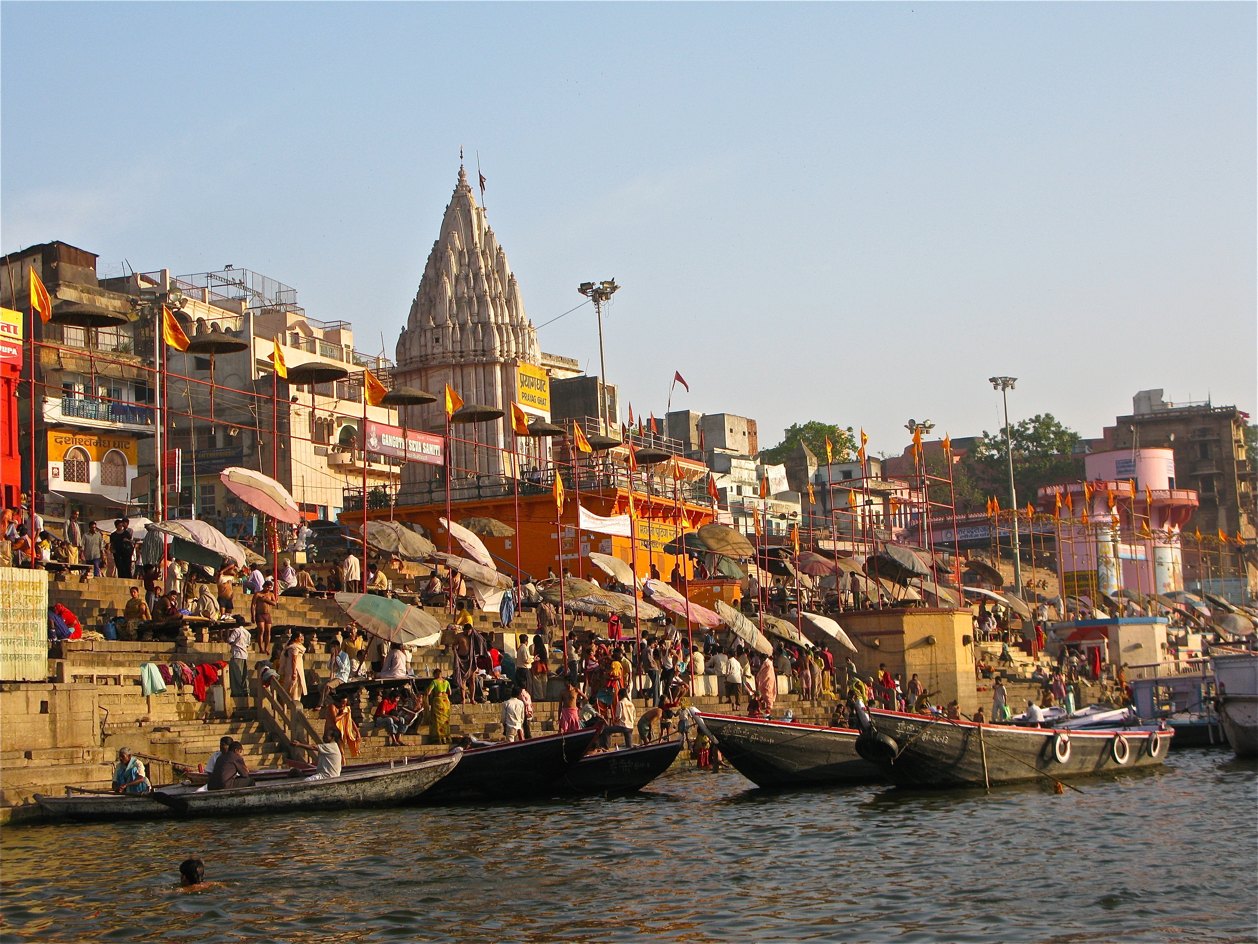
Ganges and Ghats - Varanasi by Ken Wieland
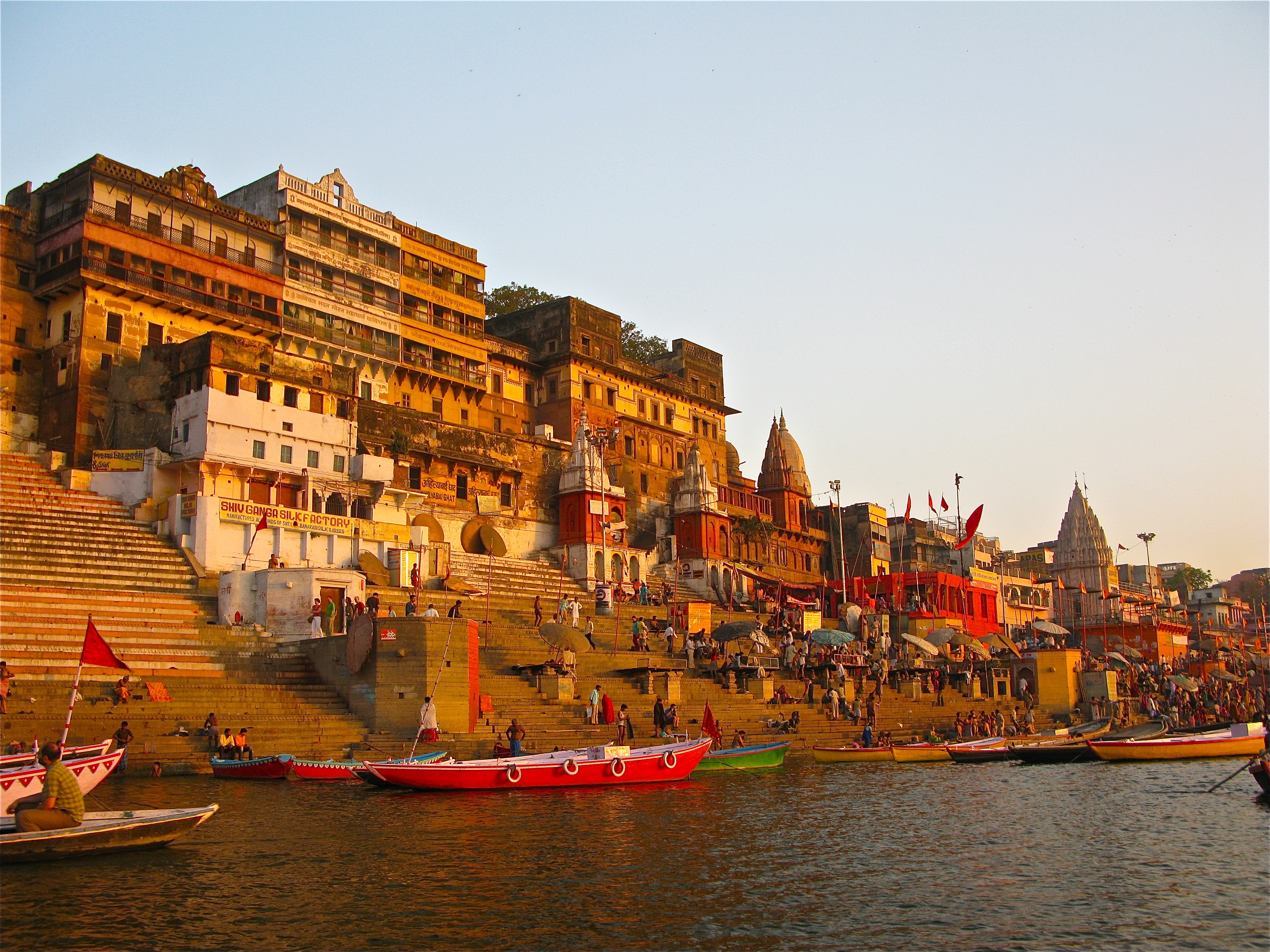
Ganges and Ghats - Varanasi by Ken Wieland
The river is the culture centre where people wash, immerse and following cremation on the banks, are floated as ashes into the holy Ganges.
[13] The Old Attock Bridge; How did I find a single bridge along over 1000 miles of possible road? I started by doing an internet search of double deck bridges and Wikipedia again had something to offer. It was not on that list. Back to the online maps then. Both Bing Maps and Google Maps have something to offer. The bridge was over a river. I was therefore looking for a convergence of rail, road, and river. Probably one of the larger rivers, but not in a plain. Past the Khyber Pass because of the terrain and lack of trains further west. Using Google's line to road feature on my existing map, Pakistan to Nepal, I was able to plot the current recommended route. I then zoomed in on the satellite view close enough to be able to see the geography of railway lines. Railway lines cut sweeping curves or straight lines through an area which show up quite distinctively, compared to a road. I then started at the Khyber Pass and followed the route proposed by Google. I could see that some parts of the route were new, such as the motorway, and therefore amended the route back to the old road, which is fortunately still called the Grand Trunk Road. Through Peshawar, and back out into the countryside. Again the Google route deviated north, crossing the Indus river. Zoom in further. No, does not meet the criteria and is not the old GTR. Drag the route back onto the GTR and watch Google recalculate. Follow that revised route and come to two sweeping curved bridges over the Indus. Than does not look right for the time, so trace the riverbank further south.
View Trans Asia 1975 - Pakistan to Nepal in a larger map
Yes, that looks more as if it meets the criteria. A rail over
road bridge across a river. Establish the location and
then Google search for information on the bridge there. It all comes
together. Location and article verified. Simple really, just a case
of a little perseverance. Green tag marks the spot.
[14] Gorakhpur. I was trying to find out about the bridge across the Rapti River on the approach to Gorakhpur as the Map gives a slight hint of an old bridge no longer in existence. I found this site about a lone cyclist. However, I have not been able find any proof of this conjecture. There is mention of bridges in the area being washed away, but it the 1870s. There is also evidence of boat bridges and fords, at certain times of the year, or annual cycle of rains. It is therefore probable than the bridge I crossed has since been duplicated adjacent to the bridge Probably completed 2004. Another bridge has also been constructed across the Rapti River as part of the Bypass. The Bypass bridge was completed in June 1989.
Nepal
The Kingdom of Nepal
View Trans Asia 1975 - Pakistan to Nepal in a larger map
A little closer
View Trans Asia 1975 - Pakistan to Nepal in a larger map Day one
View Trans Asia 1975 - Pakistan to Nepal in a larger map
In Nepal, the economy is dominated by agriculture. In the late 1980s, it was the livelihood for more than 90 percent of the population, although only approximately 20 percent of the total land area was cultivable, it accounted for, on average, about 60 percent of the GDP and approximately 75 percent of exports. Since the formulation of the Fifth Five-Year Plan (1975–80), agriculture has been the highest priority because economic growth was dependent on both increasing the productivity of existing crops and diversifying the agricultural base for use as industrial inputs. According to the World Bank, agriculture is the main source of food, income, and employment for the majority.
[16] Rice is the most important cereal crop. In 1966 total rice production amounted to a little more than 1 million tons; by 1989 more than 3 million tons were produced. Fluctuation in rice production was very common because of changes in rainfall; overall, however, rice production had increased following the introduction of new cultivation techniques as well as increases in cultivated land. By 1988 approximately 3.9 million hectares of land were under paddy cultivation. Many people in Nepal devote their lives to cultivating rice to survive. In 1966 approximately 500,000 tons of corn, the second major food crop, were produced. By 1989 corn production had increased to over 1 million tons.
For attribution of photos follow link to articles,
A and
B. Part of the article is reproduced here to preserve it in case
it is updated in accordance with this wiki note;
This article is outdated. Please update this article to reflect recent events or newly available information. (November 2010).
Gurkha
[17] Gurkha recruitment has been mainly from Nepali hill tribes such as the Magar, Gurung, Tamang, Sherpa, Chhetri, Thakuris, Rai and Limbu, although original Gurkhali soldiers were comprised mainly of Chhetri, Thakuri, Gurung, and Magar ethnics.
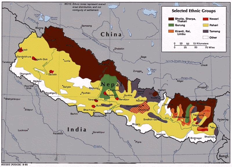
The map shows selected ethnic groups of Nepal: Bhotia, Sherpa, Thakali; Gurung; Kiranti, Rai, Limbu; Newari; Pahari; Tamang
Nepal is mountainous country and 73 % of territory is either mountain or hilly region. Constructing good road is one of big challenges in Nepal. There are many road accidents all over the year but most occur especially in summer. Some pictures from Nepal.