Auntie_Let_and_Uncle_Percys_wedding_1M.jpg
Weddings

Wedding of Let and Percy

Peggy_and_Normans_wedding_1M.jpg
Family

Wedding of parents,

Peggy and Norman

A_tomb_inside_Bath_Abbey_1M.jpg
Deaths

A Tome inside Bath Abbey

Merchant_Navy_War_Memorial_1M.jpg
Places

Merchant Navy War Memorial

Golden_Hinde_1M.jpg
History

Golden Hinde, London

Olympics_Torch_Relay_passes_through_Sutton_1M.jpg
People

Olympic Torch carrier running through Sutton 2012

Temple_Bar_Memorial_1M.jpg
Stories

Temple Bar Memorial

HRH_Queen_Elizabeth_1M.jpg
Royalty

HRH Queen Elizabeth II in Epsom

London_Bridge_Station_remodelling_1M.jpg
Occupations

Railway Permanent Way (Track) workers

at London Bridge remodelling

Golden_Anniversary_2009_Group_1M.jpg
Anniversaries

Golden Anniversary

Peter and Gloria 2009

previous arrow
next arrow

Places

South Stoneham Registration District


South Stoneham Registration District

  • Registration County : Hampshire.
  • Created : 1.7.1837.
  • Abolished : 1.4.1927 (to become part of Eastleigh registration district).
  • Sub-districts : Millbrook, St. Mary Extra, South Stoneham.
  • GRO volumes : VII (1837-51), 2c (1852-1927).


  Registration District South Stoneham

Sholing


Sholing, Bitterne, Hampshire


Domesday Book

There appears to be no mention of Sholing in the Domesday Book, at least in that form of spelling. However there is an entry for Hound.

Domesday Book HoundHound was a settlement in Domesday Book, in the hundred of Mansbridge and the county of Hampshire.

It had a recorded population of 23 households in 1086, putting it in the largest 40% of settlements recorded in Domesday (NB: 23 households is an estimate, since multiple places are mentioned in the same entry).

The image is an extract of the Domesday Book, fortunately transcribed for us.

Land of Hugh of Port

Households

Households: 31 villagers. 9 smallholders. 6 slaves.

St Mary's Church Southampton

St Mary's Church, Southampton

Situated in the angle of St Mary's Street and Chapel Road, St Mary's, although outside the town walls, is regarded as the mother church of Southampton. The original church dates back to the Saxon period, the minster at Wic (Hamwic), the forerunner of the medieval St Mary’s, being mentioned in Saxon charters of 713 and 776. St Mary’s was not directly named in the Domesday Book in 1086 but was probably one of the churches mentioned in connection with the manor of South Stoneham. John Leland writing in 1546 repeats a traditional story that the church was completely rebuilt in the 12th century thanks to the efforts of Queen Matilda.

89 Grove Street, Southampton


89 Grove Street, Southampton

Where is Grove Street?

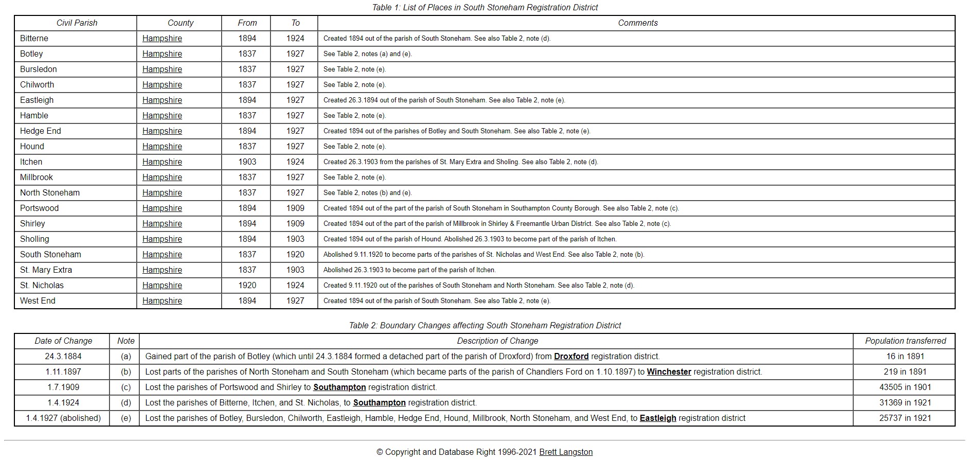
It is in the Chapel area or St. Mary's area of what was the town of Southampton, Hampshire, England.

The Sotonpedia entry is;

Grove Street and Grove Court

Grove Street

Runs south/north from Chapel Road to Bevois Street in St Mary’s. It is part of the traditional road from Hamwic to Northam, though its predecessor, Golden Grove, followed a slightly different course.

Grove Street Cottages

In the 19th century these cottages were situated on the west side of Grove Street, south of Bevois Street.

Grove Court

A 19th century Court in Grove Street, on the west side to the north of James Street.

Tithe Apportionment - Collection


Tithe Apportionment - Collection

This page is dedicated to Mr Gerry Dutton of Basingstoke whose work on the The North Hampshire Tithe Map Project and the resultant website gave me the inspiration to consider my work on Tithe Apportionment and Maps as a collective as well as the previous thought of only including the work within the relevant One Place Studies or articles. Thank you for the inspiration.


In order of my creation of the Articles

Tithe Apportionment - Sopley

Tithe Apportionment - Millbrook

Tithe Apportionment - Whiteparish

Tithe Apportionment - Nursling

Ordnance Survey Drawings
Ordnance Survey Drawing - Nutshalling - Nursling

Nursling One Place Study


Nursling One Place Study

A Study of the Parish of Nursling in the County of Hampshire, or sometime known as the County of Southamptonshire.

I refer you to the Millbrook One Place Study in the first instance. That has a lot of the background information which would be repetitive if just repeated here. 

Nursling has also been called Nutshalling as can be seen in the Ordnance Survey drawing held at the British Library. Nutshalling is circled in blue. The nearby Grove Place is circled in green, the seat of Sir Charles Mills. Shirley, in the adjacent parish of Millbrook is circled in orange.

Subcategories


Flag Counter