Taylor's Map of Hampshire 1759
The website for Old Hampshire Maps and Other Historic Resources is a most excellent source of information which I often refer to.
I normally click on the top left icon, Old Hampshire Mapped, but believe that the one next to it on the right is more extensive and gets to the same maps and more.
This section could be called an indulgence to my lifelong fascination with maps and travel. Maps can tell you so much more than just how to get from A to B. Maps over time add to so much more.
In particular this is to do with Taylor's Map of Hampshire 1759, but as a whole, not just the subject settlement or parish which is the normal focus of my attention.
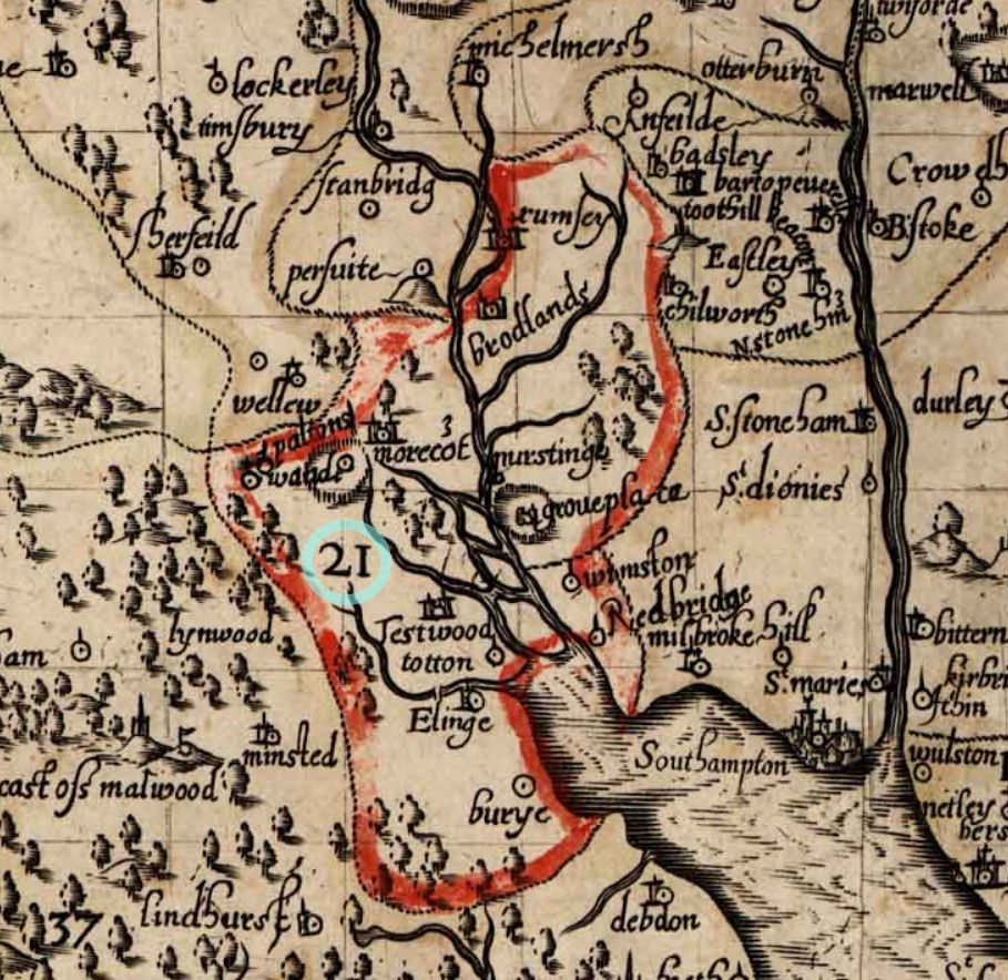
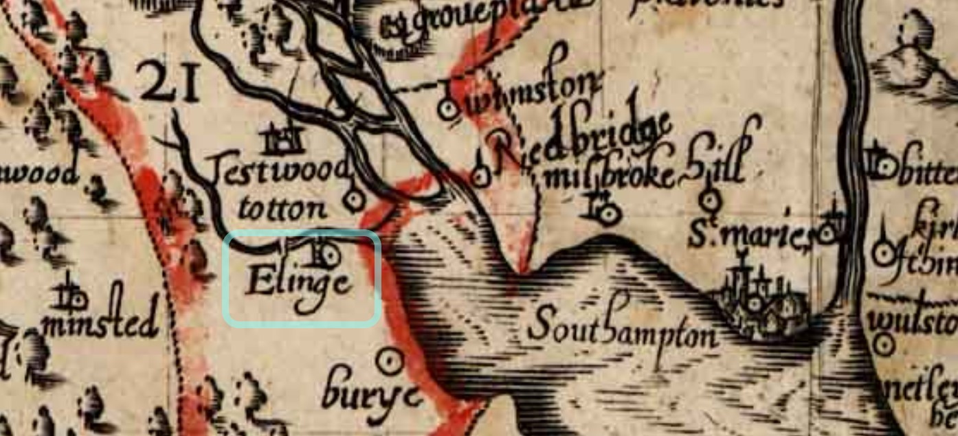
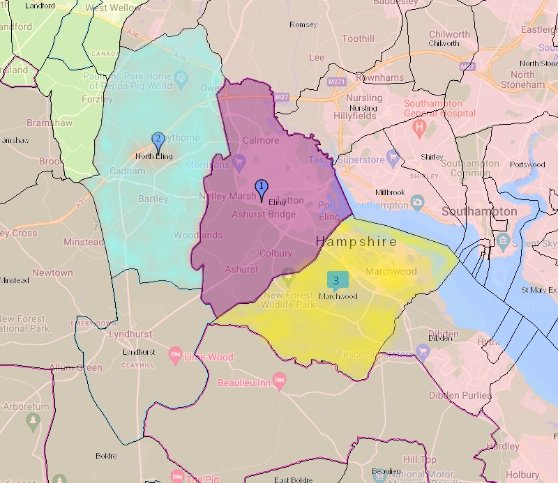
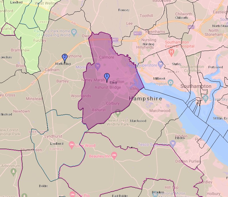
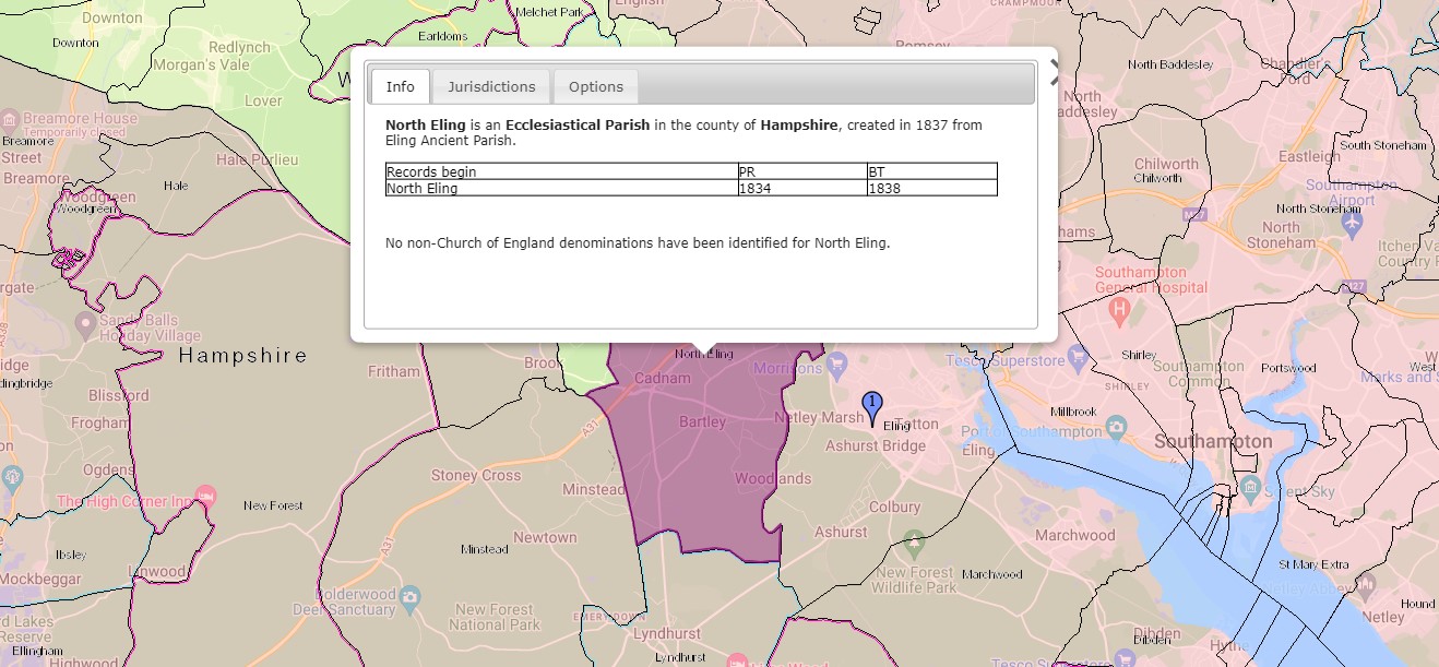
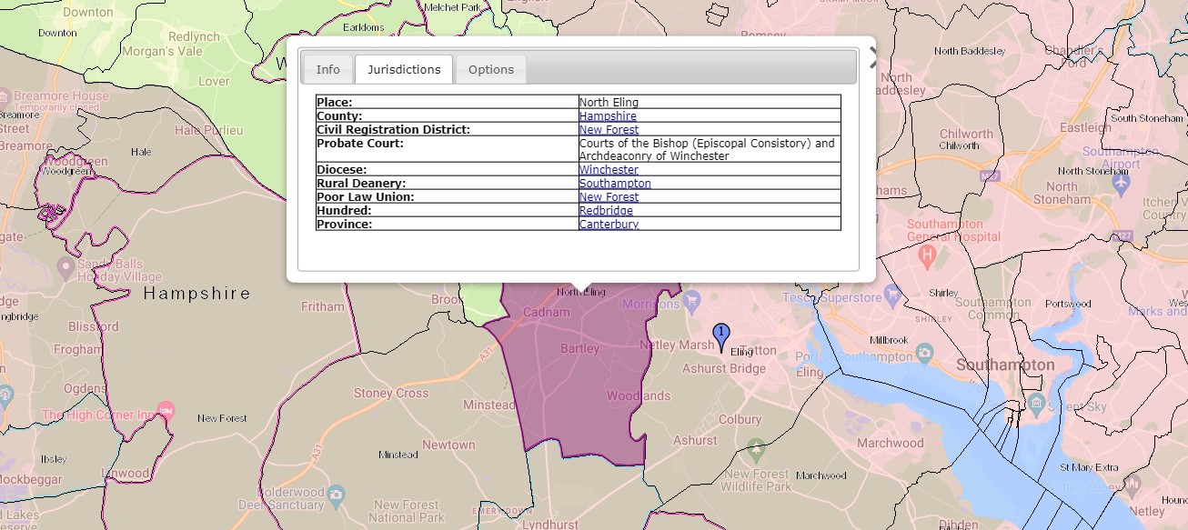
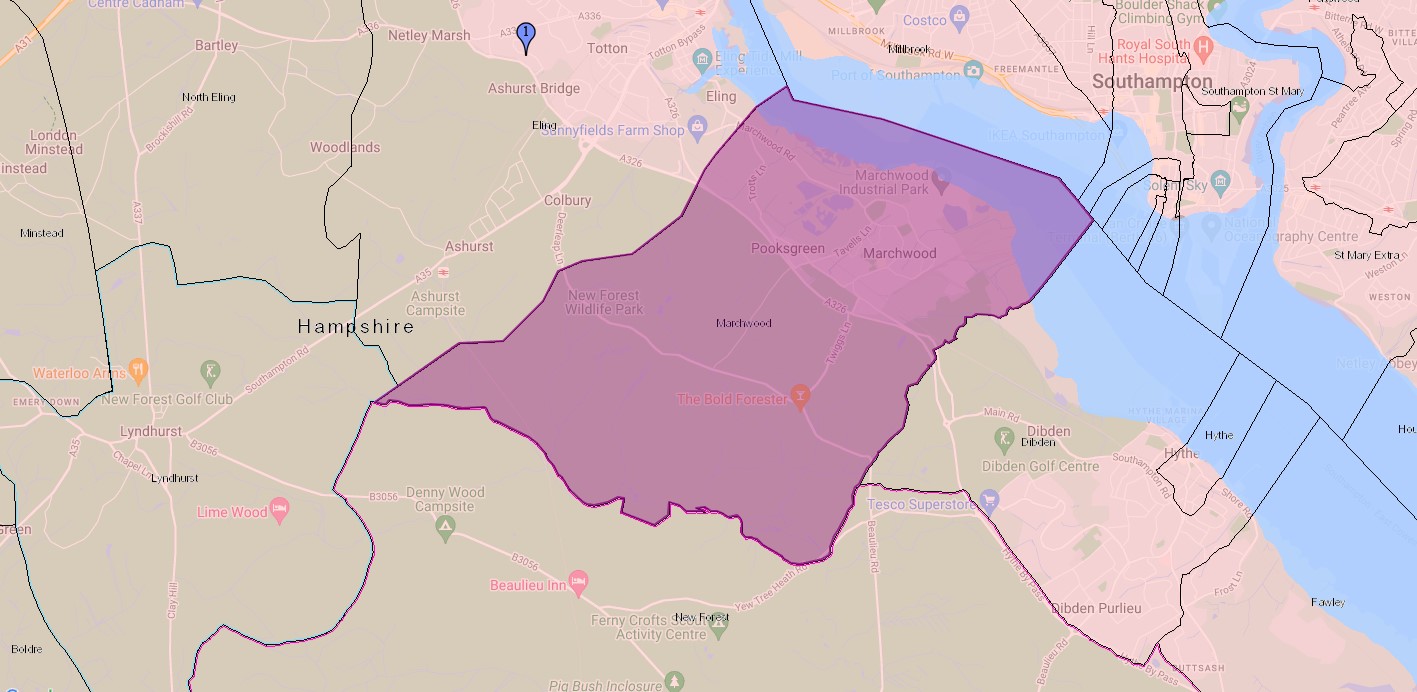
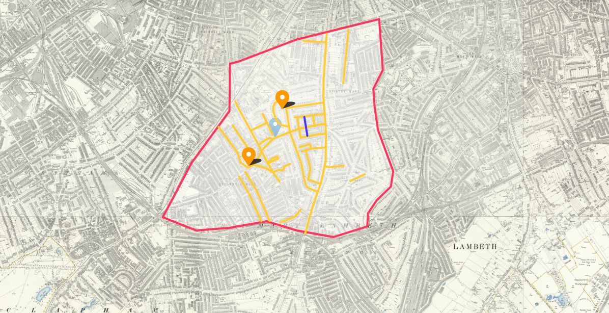
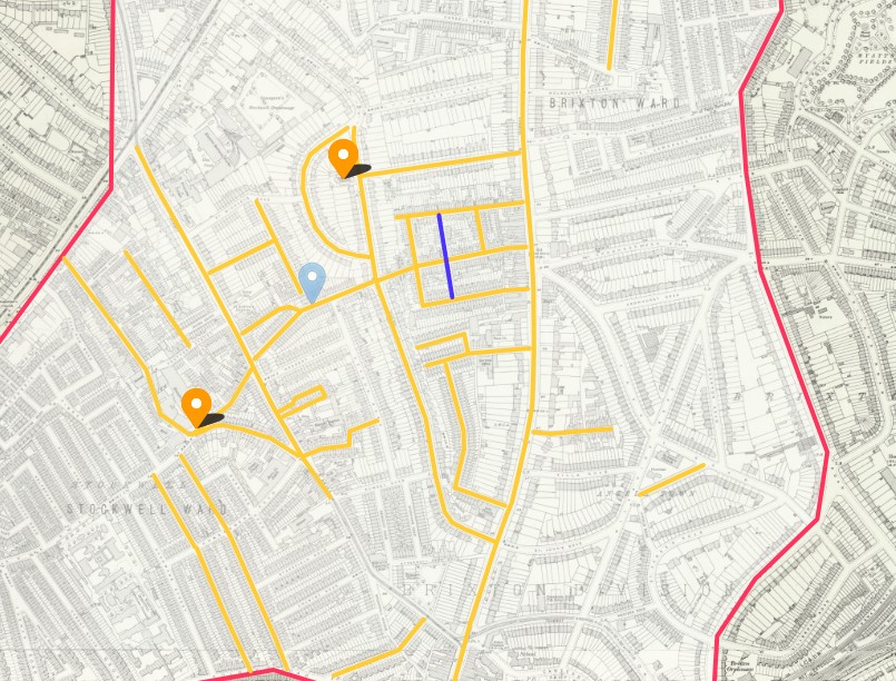
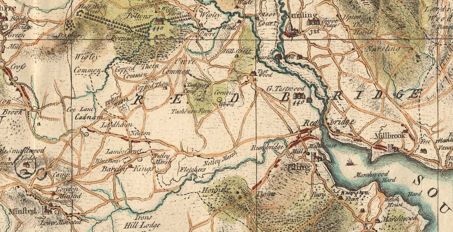
If you are looking at this via an article about Eling you may notice that the first two maps are part of Section 33 with the focus on Eling, repeated here as an example of the use of Taylor's Hampshire Map.
Taylor's Hampshire 1759
Sections - An example in use.
Taylor's Hampshire 1759 - Section 33.
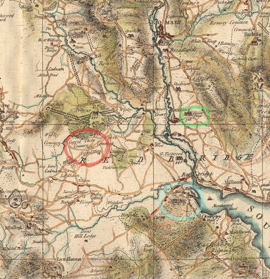
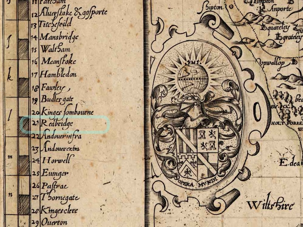
Circled in green, Grove Place, in Nursling, is not part of this story, but does get a mention elsewhere on this site. Eling, the settlement, circled in blue, is the centre of attention. Eling the parish, takes up a large portion of the map, and the Hundred of Redbridge takes up even more. Extending to Romsey
Copped Thorn Common and Copped Thorn are circled in red, and turn up later in our story, under a slightly changed name.
I will have to look up house 440 at Poltons. It is interesting that Great Testwood carries the same number. Poltons is now known as Paultons Park - Home of Peppa Pig World. How things change.
The estate can be traced back to 1086 where the ‘Paulet’ manor was in the possession of Glastonbury Abbey. The house became derelict and burned down in a great fire on 5 November 1963. Click the link to read about the Estate's History.
The whole of the map
The map below is just an indulgence. The original Taylor's map of Hampshire was in six sheets. Form the source website I created 48 map tiles, and then used technology to stitch them together. This is the result. As a whole map you can see the skill and the decoration, as well as the cartography in the details.

It is a shame that Microsoft Deep Zoom is no longer available as that would have potentially provided almost endless zoom into the above map whilst still allowing the website to function. On the original, I can zoom in to 300% and see every detail. Note bad for a stitched piece of work.
I will try to find an alternative way. Which I think I may have done, hopefully without slowing the page down too much. As well as this Genealogy website I have a Photography website hosted on SmugMug, which is a commercial site for professional photographers, but I just use it to host my photos. The price list just comes with the hosting.
Initially it may look the same as the one above, as it tries to fit the screen, but click on it and it will open in SmugMug and then you will be surprised exactly how far you can zoom in until it starts to get a bit blurry. So far it opens in the same window, so please not forget to come back, or open a duplicate window. However, as nice as it is to see the map whole, with all the associated artistry and decoration, if looking for detail, it is best to revert to the original website and find the Section you need. Even clearer images, just in 48 tiles. That is how I will set about recreating the list of Gentlemans Names, below. The whole map will help with the location of the section, and the section on the website will be the source of the transcription.
When I created the 48 tiles I had to zoom to 33% to get the whole tile within the screen size for a screen shot. If I repeated the exercise with a much larger screen and the images on full screen, therefore less reduction, the resultant whole map may well be better, but it would still be stitched. Also, it is good to refer to the original site for the detailed sections, after all, it is their work that enabled this.

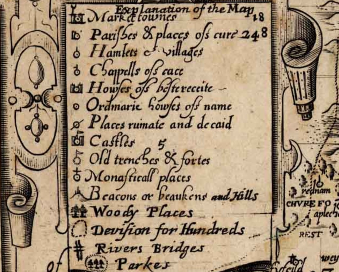
Gentlemen's Names
Index of Gentlemen's Names on Taylor's Map of Hampshire 1759
| Assumed abbreviations. | Assumed name abbreviations. | |
|
|
|
|
A
| Name | Property Code | Place | |
|---|---|---|---|
| A | Late Rt Hon. Ld Arundell | 1 | |
| Rt Hon. Ld Anson | 2 | of Soberton | |
| Rt Hon. Ld Annesly | 3 | of Farnboro place | |
| Sir Fitzgerald Aylmer | 4 | of Hambledon | |
| Ambrose V Admiral Esq | 5 | Earlstone | |
| Richd Nevil Esq | 6 | of Aldworth | |
| Saml Atkins Esq | 7 | of Southwick | |
| Herbert Aubrey Esq | 8 | Herefordshire | |
| Hen. Archer Esq | 9 | of Hale | |
| Thos Aylmer | 10 | of Petersfield | |
| Mr Will. Abree | 11 | Winton | |
| Revd Mr Ash R. of Cheriton | 12 | Cheriton | |
| Revd Dummer Andrews | 13 | Swathling | |
| Revd Dr Ayscough Preb : Winton | 14 | Winton | |
| Revd Mr Acton R. of Bentworth | 15 | Bentworth |
...
B
| Name | Property Code | Place | |
|---|---|---|---|
| B | His Grace the Duke of Beaufort | 16 | |
| His Grace the Duke of Bedford | 17 - Section 54 | E Stretton | |
| His Grace the Duke of Bolton | 18 - Section 65 | Hackwood Park | |
| Rt Hon: Ld V. Bateman | 19 | ||
| Rt Hon: Ld Brook | 20 | ||
| Rt Hon: Ld Bruce | 21 | ||
| Rt Revd the Bishop of Bangor | 22 | ||
| Sir John Barrington Bart | 23 | Swainton I.W. | |
| Wm Baker Esq Alderman of London | 24 | ||
| Geo Baker Esq | 25 | Brockenhurst | |
| Tho Baker Esq | 26 | Farnham | |
| Wm Baker Esq | 27 | Mattingley | |
| John Barnard Esq | 28 | Arlesford | |
| Mag Baltin Esq | 29 | Burcombe | |
| Thos Bates Esq | 30 | Alton | |
| Bartley Esq | 31 | of Borton Mill | |
| Hon. & Revd Mr Chute Barrington | 32 | ||
| Revd Dr Barton F. Winchester Coll. | 33 | ||
| Revd Mr Barton R. of Burriton | 34 | Burriton | |
| Revd Mr Bartholmy | 35 | S Stoneham | |
| Mr Barns Bailey | 36 | Overton | |
| Mr Barr | 37 | of the Crown Winchester | |
| Mr Baverstook | 38 | Alton | |
| Osmond Beauvoir Esq | 39 | ||
| Wm Beckford Esq | 40 | ||
| Richard Beckford Esq | 41 | ||
| Julines Beckford Esq | 43 | ||
| Capt. Marshal Berry | 44 | ||
| Revd Mr Beacon Rec. of Colborne | 45 | Colborne IW | |
| Thos Bigg Esq | 46 | Andwell | |
| Wm Birch Esq | 47 | S. Warnborough | |
| Mr Birt, Atty at Law | 48 | Lymington | |
| Mr Bird Atty at Law | 49 | Andover | |
| Revd Mr Bigg R. of Wortin | 50 | Wortin | |
| Saml Blackwell Esq | 51 | Northall | |
| Brydges Blashford Esq | 52 | Osborne I.W. | |
| John Blake Esq | 53 | Watcombe | |
| John Blashford Esq | 54 | Boncombe | |
| Rowland Blockman Esq | 55 | Soberton | |
| Revd Mr Blair | 56 | of Whitchurch | |
| Thos Bludnorth Esq | 57 | of Holt | |
| Hon Majr Genl Bockland | 58 | Knighton I.W. | |
| Wm Bolton Merchant | 59 | of Portsmouth | |
| Richd Bonham Esq | 60 | of Arlesford | |
| Henry Bonles Esq | 61 | of Windsor | |
| Mr Benj Bound | 62 | Ringwood | |
| Revd Mr Bowles Fell of Winchester Coll. | 63 | ||
| James Blake Gent. | 64 | of Brook I.W. | |
| Philip Bracebridge DD | 65 | Drayton | |
| NOT USED | 66 | ||
| John Brett Esq | 67 | ||
| Edwd Bramston Esq | 68 | Hall Place | |
| Barnard Brocas | 69 | of Beausepair | |
| Robr Bristow Esq | 70 | Micheldever | |
| John Brown Esq | 71 | Gatcomb | |
| Pusey Brook Esq | 72 | of Portsmouth | |
| Samson Bourn Esq | 73 | ||
| Thos Bonreman Esq | 74 | of Brook I.W. | |
| Dr Brown Provost Queens Coll. Oxon | 75 | ||
| Duncomb Briston DD | 76 | ||
| Mrs Bridges | 77 | Avington | |
| Mr John Bricknell | 78 | Westmeon | |
| Revd Mr Boisdaune | 79 | Southampton | |
| Lewis Buckle Esq | 80 | Borden | |
| Thos Bucknell Esq | 81 | of Portsmouth | |
| John Buttler Esq | 82 | of Bramshott | |
| James Burton Esq | 83 | Crux Easton | |
| Wm Burch Blounce Esq Gent | 84 | ||
| James Coventry Bulkley Esq | 85 | Fordingbridge | |
| Harry Burrard Esq | 86 | Wallhampton | |
| John Burrard Esq | 87 | Lymington | |
| James Burrow Esq | 88 | ||
| Revd Dr Burton | 89 | Winchester | |
| Revd Mr John Burroughs | 90 | Abbots Ann | |
| John Buller Gent | 91 | Bunghurst | |
| Buckler Esq | 92 | Bottramsly | |
| Burningham Gent | 93 | Froyle |
C
| Name | Property Code | Place | |
|---|---|---|---|
| C | His Grace the Duke of Chandos | 94 | Biddesden |
| Rt Hon Marquis of Carnarvon | 95 | ||
| Rt Hon Earl of Clanricarde | 96 | Warnford | |
| Rt Hon Countess of Coningsby | 97 | ||
| Rt Hon Ld Carpenter | 98 | Longwood | |
| Rt Hon Ld Cardigan | 99 | ||
| Sir Harry Calthrop | 100 | ||
| Sir Charles Chester Bart | 101 | ||
| Sir Talbot Clark Bart | 102 | Heckfield | |
| Sir Monoux Cope Bart | 103 | Bromshill | |
| Sir Villiers Charnocke Bart | 104 | Winton | |
| Revd Dr Cheney Dean of Winchester | 105 | ||
| John Chute Esq | 106 | of the Vine | |
| Richd Champneys Esq | 107 | of Cams | |
| John Clark Esq | 108 | the Hill Herefordshire | |
| Benjn Clark Esq | 109 | Hinton | |
| Charles Clutterbuck Esq | 110 | S. Hampton | |
| John Carter Esq | 111 | Portsmouth | |
| Nichs Cooke Esq | 112 | Newport I.W. | |
| Richd Cooper Esq | 113 | Ditcham | |
| Ralph Congreve Esq | 114 | Aldermaston | |
| Thos Coward Esq | 115 | Spergrove | |
| W. Coleman Esq | 116 | Newport | |
| Laeder Coxin Esq | 117 | Scalding Alley London | |
| T Cowslade Esq | 118 | Broadline | |
| Dr Chace | 119 | Heckfield | |
| Wm Cooper Gent. | 120 | Moncton | |
| Coombs Gent | 121 | Hartley Row | |
| Velters Cornwall Esq Membr for Herefordsh | 122 | ||
| Heny Compton Esq | 123 | Bistorn | |
| Richd Cox Esq | 124 | Sarsan | |
| Jeremiah Cray Esq | 125 | Ibbesley | |
| Dr Clifton | 126 | London | |
| Mr Robt Clarke Attorney | 127 | Newport | |
| Mr Richd Cowlam Mayor | 128 | Newport | |
| Mr Benjn Collins | 129 | Salisbury | |
| Mr Compigncy | 130 | Winchester | |
| Tho Cudden Esq | 131 | Middle Temple London | |
| Revd Mr Cuttler | 132 | Droxford | |
| Revd Mr Cotton R of St Lanrence Winton | 133 | ||
| Mr Custman | 134 | of Anstes | |
| Eli: Christmas Gent | 135 | Alton | |
| James Cummins Esq | 136 | Eversly |
D
| Name | Property Code | Place | |
|---|---|---|---|
| D | Rt Hon Earl of Dartmouth | 137 | Basingstoke |
| Rt Hon Ld Dela Warr | 138 | Bolderwood Lodge | |
| Peter Daval Esq | 139 | No. 6 Pump Court Mid Temple | |
| Wm Davis Esq | 140 | Twyford | |
| Geo Dacre Esq | 141 | Mernwell | |
| Wm Dansey Esq | 142 | of Brinsop Herefordshire | |
| James Dawkins Esq | 143 | Late of Laverstoke | |
| NOT USED | 144 | ||
| Henry Dawkins Esq | 145 | of Laverstoke | |
| John Delme Esq | 145 AGAIN | of Collingbourne | |
| Peter Delme Esq | 146 | Titchfield | |
| Thos Day Esq | 147 | of West Cowes | |
| F. Blake Delaval Esq Memr for Stockbridge | 148 | ||
| Hen. Dennis Esq | 149 | Bishops Waltham | |
| James o Donald Esq | 150 | ||
| Charles Dormer Esq | 151 | of Iddsworth | |
| Diggle Esq | 152 | Yately | |
| Wm Drake Esq | 153 | Amersham | |
| Thos Lee Drummer Esq | 154 | Cranbury | |
| James Dicker Esq | 155 | Overton | |
| Wm Draper Esq | 156 | of Froyle | |
| Wm Draper Esq | 157 | of London | |
| J Dicker Esq | 158 | of Sydmonton | |
| Revd Mr Dangerfield R. of Goodrich Herefordsh | 159 OR 150 | ||
| Mr Thoms Dickenson Attorney | 160 OR 169 | Newport I.W. | |
| Revd Edwd Davies V. Thorley I.W. | 161 | ||
| Revd Mr Dennis R. of Bromshott | 162 | ||
| Revd Mr Denison R. Chalkton | 163 | ||
| J. Dosswell Gent. | 164 | Winton | |
| John Duthy Gent. | 165 | Arlesford | |
| Mr George Durnford | 166 | Winchester |
E
| Name | Property Code | Place | |
|---|---|---|---|
| E | Rt Hon Earl of Egglingtoun | 167 | Crawley |
| Rt Hon Lord Edgecumbe | 168 | ||
| Sir John Elvill Bart | 169 | ||
| Harry Earle | 170 | of Grotly | |
| John Earle | 171 | ||
| John Eyre | 172 | Landford Wilts | |
| Ellis | 173 | S. Hampston | |
| Mr Sergeant Eyre | 174 | Botly Grange | |
| Revd Dr Eden Archdeacon of Winchester | 175 | ||
| Revd Mr Henry Egerton | 176 | Settrington YorkShs | |
| Revd Mr Exton Preb of Winchester | 177 | ||
| Mr Mattw Easton | 178 | of Alton | |
| Mr Thos Eyre | 179 | of Fareham |
F
| Name | Property Code | Place | |
|---|---|---|---|
| F | Sir Matthew Fetherston haugh Bart | 180 | |
| Robt Forder Esq | 181 | West Sparkford | |
| Gorges Foyle Esq | 182 | of Kimpton | |
| Revd George Fothergill D.D. | 183 | Bramley | |
| Revd Marrian Feaver | 184 | Melbury Dorset | |
| Revd Henry Fuller | 185 | Stonham | |
| Revd Mr Foyle R. Kimpton | 186 | ||
| Mr Fitchet | 187 | of the Grove I.W. | |
| Mr Foquett Attorney | 188 | Newport I.W. | |
| Mr Richd Figg Churchers Coll. | 189 | Petersfield | |
| Mr Faithfull | 190 | Overton | |
| Mr Andrew Fielder | 191 | S. Hampton |
G
| Name | Property Code | Place | |
|---|---|---|---|
| G | Sir Wm Gardiner Bart | 192 | Roch Court |
| George Garnier Esq | 193 | of Wickham | |
| Tho Gatehouse Esq | 194 | of Wallop | |
| John Gauntlett Esq | 195 | of Winton | |
| George Grey Esq Collonel | 196 | ||
| Wm Green Esq | 197 | ||
| Thos Green Esq | 198 | of Crondale | |
| H. Granger Esq | 199 | of Wortin | |
| Andrew Gother Esq | 200 | Billingham I.W. | |
| Wm Goodwin Esq | 201 | W. Cowes | |
| Geo Goldwyre Esq | 202 | Somerford | |
| Edwd Goddard Esq | 203 | Shargroves | |
| Edwd Grose Esq | 204 | St Hellens I.W. | |
| Edwd Gibbons Esq | 205 | Buriton | |
| Hon Coll Griffin Esq Memb for Andover | 206 | ||
| Richd Gifford Esq | 207 | of Hursley | |
| Grove Buckland Esq | 208 | All Saints Devon | |
| Thos Grimes Esq | 209 | Yaford I.W. | |
| John Gringo Esq | 210 | Fareham | |
| Lewis Guiguer Esq | 211 | Rookly | |
| Thos Guillim Esq Major of Ld Robt Berties Regt | 212 | ||
| Thos Godwin Esq | 213 | of Week | |
| Capt Gilbert Esq | 214 | Arch Lands | |
| Revd Dr Golding Wared of Winchester Coll. | 215 | ||
| Edwd Grace Gent | 216 | of Winton | |
| Mr Glasspole | 217 | Winton | |
| Wm Gregory Senr Gent | 218 | Odiham | |
| Mr T Gibson | 219 | Petersfield | |
| Mr Alexr Goss | 220 | Ringwood | |
| Mr James Gumm | 221 | Newport I.W. | |
| Mr Groves | 222 | Heckfield |
H
| Name | Property Code | Place | |
|---|---|---|---|
| H | Rt Hon & Rt Revd the Bishop of Hereford | 223 | |
| Sir Thos Heathcote Bart | 224 | Hursley | |
| Sir Edwd Hawke Kt of the Bath | 225 | Swathling | |
| Sir Edwd Hulse Bart | 226 | Breamore | |
| Geo Hannay Esq | 227 | Soberton | |
| Thos Hall Esq | 228 | of Moundsmore | |
| Jos Hackman Esq | 229 | Lymington | |
| Thos Harrison Esq | 230 | Alton | |
| Hon Admiral Homar Esq | 231 | ||
| Thos Harrison Esq | 232 | Amery | |
| Wm Hawley Esq | 233 | West Green | |
| Peter Hawker Esq | 234 | Long Parish | |
| Late Revd Mr Joseph Hall | 235 | Weyhill | |
| Hon & Revd Mr John Horley | 236 | ||
| John Hawker Gent | 237 | Portsmouth | |
| T Harris Gent | 238 | Baughurst | |
| Hall Gent | 239 | London | |
| John Hasker Gent | 240 | Norrington | |
| Mr John Hasker | 241 | Laverstoke | |
| Mr Thos Hasker | 242 | Southampton | |
| Revd Mr Harrison | 243 | Titherley | |
| Mr Haskoll | 244 | of Winton | |
| Dr George Hay | 245 | ||
| James Harris Esq | 246 | Dibden Sarum | |
| Hon Richd Herbert Higheler Esq | 247 | ||
| Revd Mr Henchman V. Basingstoke | 248 | ||
| Rt Hon Henly Ld keeper of ye great Seal | 249 | Grange | |
| Richd Hicks Esq | 250 | Pennington | |
| Joseph Hinxman Esq | 251 | N Hinton | |
| Mr Edwd Hicks | 252 | Lymington | |
| Revd Mr Wm Hillman | 253 | Eastclose | |
| John Lee Hill Esq | 254 | Cholderton | |
| Revd Mr Hillman R of Dean | 255 | ||
| Revd Mr Hinkerman R Houghton | 256 | ||
| Henry Hoare Esq | 257 | of Quarley | |
| Late Robt Hoblyn Esq | 258 | ||
| Edwd Hooper Esq | 259 | of Hurn Court | |
| Andw Hopegood Esq | 260 | ||
| Hon Major Genl Heny Holmes Esq | 261 | Appledorcomb | |
| Thos Holmes Membr for Yarmouth I.W. | 262 | ||
| John Harwood | 263 | of Dean | |
| Wm Horner R Waltham | 264 | ||
| Revd Dr Hoadly Chancellor | 265 | ||
| Mr Strangeways Horner | 266 | Melbury Dorset | |
| Geo Holme D.D. | 267 | Headley | |
| Benjn Hubert | 268 | Breamore | |
| Wm Huggins | 269 | Headly Park | |
| Frank Hugonir | 270 | Nursted | |
| R Hughes Commissr Portmth Dock | 271 | ||
| Late Wm Hunt | 272 | Basingstoke | |
| Geo Huish Gent | 273 | Portsmouth | |
| Mr Humphreys | 274 | Titchfield |
I & J
| Name | Property Code | Place | |
|---|---|---|---|
| I & J | Revd Dr Jackson V. Titchfield | 275 | |
| Mr Geo Jackson | 276 | Arlesford | |
| Richd Jervoise Esq | 277 | Herriard | |
| John Jolliffe Esq | 278 | Petersfield | |
| Wm Jolliffe Esq | 279 | Pit-place I.W. | |
| Joshua Iremonger Esq | 280 | Wherwell | |
| R. Jewer of Frimley Esq | 281 | ||
| Robt Jeffreys Esq | 282 | Twyford | |
| Jmber or Imber Esq | 283 | Winchester | |
| Jones Esq | 284 | Ibthorp | |
| Mr Jmber | 285 | Winchester | |
| Jeremiah Jolliffe Gent. | 286 | I.W. | |
| Mr Joseph Jolliffe | 287 | I.W. | |
| Mr James Jolliffe | 288 | Newport I.W. | |
| Revd Mr Jones | 289 | Freemantle | |
| Revd Mr Jones R. Mollisfont | 290 | ||
| Mr Jones | 291 | of Winchester |
K
| Name | Property Code | Place | Notes on Name | Notes on Place | |
|---|---|---|---|---|---|
| K | Rt Hon Ld Kingston | 292 | Worthy | ||
| Thos Knight Esq | 293 | Chawton | |||
| Chidcoke Kent Esq | 294 | Rumsey | |||
| James King | 295 | Upton Grey | James King Esq |
Upton Grey House and (Search Reference: 364) 1741 Horne map of Upton Grey |
|
| Dr King Prinl St Mary Hall Oxon | 296 | ||||
| Ambrose Kent F. Magdalen Coll. Oxon | 297 | ||||
| Robt Keyse Gent | 298 | Ross Herefordshire | |||
| Mr Kirkpatrick | 299 | Newport I.W. |
L
| Name | Property Code | Place | |
|---|---|---|---|
| L | Rt Hon Lady Londonderry | 300 | Wainboro' |
| Sir Berley Lacy Bart | 301 | ||
| Sir Robt Ladbrook Esq Kt Aldn London | 302 | ||
| Biby Lake Esq | 303 | Middle Temple London | |
| Rt Hon Henry Bilson Legge Esq | 304 | Ladyholt | |
| Bars Eveleigh Leigh Esq | 305 | Northcourt I.W. | |
| John Leigh Esq | 306 | Fairleigh I.W. | |
| Theo Lane Esq | 307 | Hereford | |
| Benjn Lethieulier Esq | 308 | Redrice | |
| John Lisle Esq | 309 | Moylscourt | |
| Beaston Long Esq | 310 | ||
| John Limbrey Esq | 311 | Tangier | |
| Revd Dr Langbain Fel. Winchester Coll. | 312 | ||
| Dr Brown Langrish | 313 | Winton | |
| Revd Nichs Lechmere Preb. Winton | 314 | ||
| Thos Lisle D.D. | 315 | Burclere | |
| Revd Dr Louth Preb. Durham | 316 | ||
| Late Lutman Esq | 317 | Bently | |
| Dan Lashford Gent. | 318 | Winton | |
| London Gent | 319 | Ringwood | |
| Mr George Leigh | 320 | Swan Stockbridge | |
| Hen. Lys Gent | 321 | Portsmouth |
M
| Name | Property Code | Place | |
|---|---|---|---|
| M | Sir Richd Mill Bart | 322 | of Grove Place |
| Sir John Miller Bart | 323 | Lavant | |
| Hon Sir John Mordaunt | 324 | Padwell | |
| Sir Edwd Hussey Mountague | 325 | ||
| Sir Sidney Meadows | 326 | Conholt | |
| Geo Mackenzie Esq | 327 | E. Cowes I.W. | |
| Andw Malthew Esq | 328 | Heathouse | |
| Joseph Martin Esq | 329 | Ringwood | |
| Admiral Martin the Hill Esq | 330 | ||
| Richd Mill Esq | 331 | Mottisfont | |
| John Mill Esq | 332 | ||
| John Mill Esq | 333 | Bentley | |
| John Merril Esq | 333 Reused | Lainston | |
| Caren Mildmay Esq | 334 | Shawford | |
| John Milford Esq | 335 | Newtown | |
| Thos Missing Esq | 336 | Stubbington | |
| Wm Mitchel | 337 | Crotley | |
| Henry Morley Esq | 338 | Droxford | |
| Wm Mount Esq | 339 | London | |
| Robt Mitchel Esq | 340 | ||
| John Moody Esq | 341 | Havant | |
| Henry Moore Esq | 342 | ||
| Late John Mitchel Gent | 343 | St Cross I.W. | |
| James Mansfield Gent | 344 | Ringwood | |
| Josiah Musspratt Gent | 345 | Winton | |
| Monday Gent | 346 | ||
| Revd Charles Mill | 347 | Kings Samborne | |
| Revd Mr Morgan Preb. Winton | 348 | ||
| Revd Mr Morris R. of Nursling | 349 | ||
| Mr Thos Missing | 350 | Portsmouth | |
| Mr Mordo Macauley | 351 | Newport I.W. | |
| Mr Morner | 352 | Star & Garter Andover |
N
| Name | Property Code | Place | |
|---|---|---|---|
| N | Thos Newnham Esq | 353 | Winchester |
| Newman Esq | 354 | Froyle | |
| Mark Noble Esq | 355 | Wollston | |
| Nicholas Esq | 356 | Froyle | |
| Dr Russell Nash Preb. Winton | 357 | ||
| New | 358 | of Gosport | |
| T.R. Noyes | 359 | Southcott near Reading | |
| Revd Mr Nicoll R. Meonsotke | 360 | ||
| John Newman Elder Gent | 361 | Ringwood | |
| John Newen Gent | 362 | I.W. | |
| Corporation of Newport | 363 | I.W. |
O
| Name | Property Code | Place | |
|---|---|---|---|
| O | Rt Hon the Earl of Oxford | 364 | |
| Sir John Oglander Bart | 365 | Nunwell | |
| Wm Oglander Esq | 366 | ||
| Revd Thos Obourn R. Laverstoke | 367 | ||
| Revd Mr Osborne | 368 | Chilbolton |
P
| Name | Property Code | Place | |
|---|---|---|---|
| P | His Grace the Duke of Portland | 369 | |
| Rt Hon Earl of Pembroke | 370 | ||
| Rt Hon Earl of Portsmouth | 371 | Hussbourg | |
| Rt Hon Ld V. Palmerston | 372 | Broadlands | |
| Sir Seymour Pile Bart | 373 | Somerly | |
| Sir John Philips Bart Membr for Petersfield | 374 | ||
| Henry Penton Esq Membr for Winchester | 375 | ||
| Wm Pescod Esq Recorder of Winchester | 376 | ||
| James Perkins Esq | 377 | Winkton | |
| John Peachy Esq | 378 | Gosport | |
| Geo. Pitt Esq | 379 | Stratfield Saye | |
| Henry Pincke Esq | 380 | Kempshott | |
| Late Norton Poulet Esq | 381 | Rotherfield | |
| Popham Esq | 382 | Hungerford | |
| John Popham Esq | 383 | Newchurch I.W. | |
| Wm Powlet Esq | 384 | of Easton | |
| Harcourt Powell Esq Membr for Newtown I.W. | 385 | ||
| Joseph Portal Esq | 386 | Freefolk | |
| Robt Price Esq | 387 | Foxley Herefordshire | |
| John Pollen Esq | 388 | of Andover | |
| Late Richd Puckeridg Esq | 389 | Romsey | |
| Wm Pryor Esq Mayor of Hereford | 390 | ||
| Thos Pike Esq | 391 | Weyhill | |
| Revd Earlysman Peachy | 392 | Netherton | |
| Revd Mr Palmer R. Motteston I.W. | 393 | ||
| Revd Mr Paget | 394 | Wells Somersetshire | |
| Mr Edwd Palmer | 395 | Winchester | |
| Mr Samuel Pearse | 396 | London | |
| Mr Pellfold | 397 | Gosport | |
| Revd Mr Peverel V. of Ramsey | 398 | ||
| John Pitter Gent. | 399 | Hunton | |
| Mr John Power | 400 | ||
| Mr H Portsmouth | 401 | Basingstoke | |
| Revd James Plowden | 402 | Ewhurst | |
| Mr Wm Pike | 403 | Gosport | |
| Revd Mr Powlet | 404 | Chilland | |
| Mr Richd Pratt of the County Hospital | 405 | ||
| Revd Dr Primrose | 406 | S. Warnborough | |
| Revd Dr Pyle Preb. Winchester | 407 | ||
| Mr John Pitt | 408 | Glocester | |
| Edwd Pyot Gent. | 409 | Winchester | |
| Mr John Pugh | 410 | Andover | |
| Mr Edwd Parker | 411 | Alton | |
| Mr Prince | 412 | Winslade |
Q
| Name | Property Code | Place | |
|---|---|---|---|
| Q | Q NOT USED | ||
R
| Name | Property Code | Place | |
|---|---|---|---|
| R | Sir Thos Ridge Kt | 413 | Burley |
| Jonathan Rashleigh Esq | 414 | of Wickham | |
| Jemmit Raymond Esq | 415 | Woolverton | |
| John Read Esq | 416 | Cowes | |
| Christr Rawlinson Esq | 417 | upper Clotford | |
| Wm Rickman Esq | 418 | Possbrook | |
| Geo. Ridge Esq | 419 | Kilmeston | |
| Geo. Bridges Esq | 420 | Rodney New Arlesford | |
| Mattw Rolleston Esq | 421 | S Hampton | |
| Denys Rolle Esq | 422 | Titherly | |
| Thos Rothwell Esq | 423 | Coldrey | |
| Wm Ruffin Esq | 424 | Birchmoor I.W. | |
| Richd Russel Esq | 425 | Basing | |
| Revd Mr Rolleston Archdeacon of Sarum | 426 | ||
| Heny Roberts Gent. | 427 | Westanden I.W. | |
| Dr Roberts Ross | 428 | Herefordshire | |
| Wm Redston Gent. | 429 | Newport | |
| Revd Wm Roman R. of upper Clotford | 430 | ||
| Richd Russel D.D. | 431 | of Ash | |
| Revd Mr Ridding Preb. Winchester | 432 | ||
| Mr Mark Rogers | 433 | Newport I.W. | |
| Mr Robinson | 434 | Winchester |
S
| Name | Property Code | Place | |
|---|---|---|---|
| S | Rt Hon Earl of Shaftsbury | 435 | |
| Sir Thos Stapleton Bart | 436 | ||
| Sir Harry Slingsby Bart | 437 | ||
| Sir Humphry Stuart Bart | 438 | Hortly | |
| John Scanlan Esq | 439 | Sway | |
| Peter Serle Esq | 440 | of Testwood | |
| Paulet St John Esq | 441 | Dogmersfield | |
| Goodyer St John Esq | 442 | Odiam | |
| Edwd Sheldon Esq | 443 | of Winchester | |
| John Skipp Esq | 444 | Ledbury Herefordshire | |
| Hon. Hans Stanley Esq a Lord of ye Admt | 445 Shown as 440 on map | Ploton | |
| Wm Sloan Esq | 446 | of S. Stoneham | |
| Samler Esq | 447 | Battramsley | |
| Wm Smith Esq | 448 | Tidworth | |
| John Bonham Smith Esq | 449 | ||
| N.P. Smith Esq Mayor of Winchester | 450 | ||
| John Smith Esq | 451 | Wimmering | |
| Capt. Smith Esq | 452 | Mountpleasant | |
| Hon. John Spencer Esq | 453 | Rookley | |
| The Society of Mapledornwell Hatch | 454 | ||
| Thos Sheathfield Esq | 455 | Easton | |
| Humphry Sturt Esq | 456 | ||
| Simcon Stuart Esq | 457 | Hortley | |
| John Sutton Esq | 458 | Hambledon | |
| Frans Swanton Esq | 459 | Over Wallop | |
| Anthy Langley Swimmer Esq | 460 | Longwood | |
| Mr Sainsbury Attorney | 461 | Petersfield | |
| Revd Mr Sandford | 462 | Wickham | |
| Thos Serle Junr Attorney | 463 | Newport | |
| John Sewell Gent. | 464 | Champion I.W. | |
| Revd Wm Sealy R. of Bighton | 465 | ||
| Wm Seymour Gent. | 466 | Odiham | |
| Mr Serle | 467 | Winchester | |
| Mr Serle | 468 | Hortly Row | |
| Mr Serrel | 469 | Angel Lymington | |
| Revd James Scott V. Ellingham | 470 | ||
| Revd Dr Shipley | 471 | Silchester | |
| Robt Shipman D.D. | 472 | Winchester | |
| Revd Bolton Simpson | 473 | West Cowes | |
| Revd Mr Simpson R. Weyhill | 474 | ||
| Mr Wm Sharpe Junr | 475 | Newport I.W. | |
| Mr John Shackleford | 476 | Petersfield | |
| Mr Godwin Seward | 477 | Rumsey | |
| Mr S. Shipton | 478 | Basingstoke | |
| Mr Silver | 479 | Winchester | |
| Revd Richd Smith | 480 | Somborne | |
| Revd Mr Smith | 481 | Alton | |
| Mr James Spearing | 482 | Winchester | |
| Revd Mr Speed R. Martyr Worthy | 483 | ||
| J Speed M.D. | 484 | Southampton | |
| John Stevens Gent. | 485 | London | |
| Revd Mr Stevens R. of Wordhay | 486 | ||
| Revd Mr Stockwell R. of Dummer | 487 | ||
| Revd Mr Geo Strother R. Grotley | 488 | Penton | |
| P. Trotn Sone Gent. | 489 | Sowley | |
| Arthur Ashley Sykes D.D. Preb. Winton | 490 |
T
| Name | Property Code | Place | |
|---|---|---|---|
| T | Rt Hon. Earl of Tilney | 491 | Tilney House |
| Rt Hon Ld Talbot | 492 | Cadland | |
| Sir Hen. Titchbourne Bart | 493 | Titchborne | |
| Alexr Thistlewayte Esq | 494 | Southwick 20 Maps | |
| Michael Terry Esq | 495 | Dummer | |
| Wm Thomson Esq | 496 | Wield | |
| J Henry Tombes Esq | 497 | Gilbury | |
| James Tooker Esq | 498 | Catherington | |
| John Tulleken Esq | 499 | Winchester | |
| Thos Townshend Esq | 500 | ||
| Mr Robt Thorpe Tarrant | 501 | Fordingbridge | |
| Mrs Temple | 502 | Moor Park | |
| Revd Mr Thistlethwayte | 503 | Normans Court | |
| Revd Taylor R. Crawley | 504 | ||
| Mr Thos Temple | 505 | Newport | |
| Revd Mr Tindal R. Alverstoke | 506 | ||
| Mr Tombes | 507 | Winchester | |
| Revd Jos Trapp R. Stratfield Saye | 508 | ||
| Revd Mr Toll | 509 | of Grewell | |
| Revd Mr Toll R. Dogmersfield | 510 | ||
| Revd Mr Tomkins | 511 | of Breamore | |
| Revd Dr Trougheare Vicar Carrisbrook | 512 | ||
| Revd Mr Towers | 513 | Fordingbridge | |
| Mr Turner | 514 | of Newport |
U & V
| Name | Property Code | Place | |
|---|---|---|---|
| U & V | Arthur Vansittart Esq | 515 | Shottesbrook Berks |
| Thos Urry Esq | 516 | of Sheat I.W. | |
| David Urry Esq | 517 | of Afton I.W. | |
| Mr Henry Vokes | 518 | Winchester | |
| Revd Mr James Upsdale | 519 | Arlesford |
W
| Name | Property Code | Place | |
|---|---|---|---|
| W | Rt Hon Marquis of Winchester | 520 | Burley Lodge |
| Rt Hon Earl of Westmorland | 521 | ||
| Rt Revd Ld Bishop of Winchester | 522 | ||
| Rt Hon Lady Frances Williams | 523 | ||
| Lady Warren | 524 | E. Meon | |
| Hon. Ward Esq | 525 | Himley Staffordshire | |
| Sir Thos Worsley Bart | 526 | Pilewell | |
| Hon. Sir Charles Handbury Williams | 527 | ||
| Sir Edwd Worsley Kt | 528 | Gatcombe I.W. | |
| Sir Martin Wright Kt | 529 | Dreyton | |
| Abel Walter Esq | 530 | Badgely | |
| Robt Warner Esq | 531 | Bellmont | |
| Ward Esq | 532 | of Forton | |
| James Ward Esq | 533 | Crabhorn | |
| Henry Wells Esq | 534 | Brambridge | |
| Late Watts Esq | 535 | Basingstoke | |
| Herbert Westfaling Esq | 536 | Rudhall | |
| Thos White Esq | 537 | Portsmouth | |
| Cha. Whitmore Esq | 538 | Southampton | |
| John Richmond Webb Esq | 539 | Tangley | |
| John Willis Esq | 540 | Ringwood | |
| John Woods Esq | 541 | Bramshott | |
| Wm Wither Esq | 542 | Manydown | |
| Hon. Windsor Esq | 543 | Southampton | |
| Thos Windham Esq | 544 | Yateley | |
| Willm White Esq | 545 | Newport I.W. | |
| Wadham Windham Esq | 546 | Eversly | |
| Late Thos Willis Esq | 547 | Stoneham | |
| Mattw Woodford Esq | 548 | Southampton | |
| James Worsley Esq | 549 | of Stenbury I.W. | |
| Robt Worsley Esq | 550 | Pidford | |
| James Wright Esq | 551 | Doles Lodge | |
| Thos Waldron Gent. | 552 | Winton | |
| Revd Mr Walton Preb. Winchester | 553 | ||
| Revd Mr Walton R. Brixton I.W. | 554 | ||
| Revd Mr Joseph Warton | 555 | Winchester | |
| Mr James Whitehead Attorny | 556 | Newport I.W. | |
| Thos Widmore Gent. | 557 | Winton | |
| Dr Wilkes | 558 | Willenhall Staffordshire | |
| Revd Mr Willis | 559 | Hollybourn | |
| Robt Weeks Gent. | 560 | Chale I.W. | |
| Revd Mr Wavel R. St Maurice | 561 | Winton | |
| Revd Mr White R. Hursley | 562 | ||
| Revd Mr Winter | 563 | Portsea | |
| Revd Mr Wood R. of Niton I.W. | 564 | ||
| Revd Mr Woodford R. Shallfleet I.W. | 565 | ||
| Revd Mr Woodroffe Preb. Winton | 566 | ||
| Revd Robt Worgan | 567 | Andover | |
| Revd Bennet Worgan R. Linkinholt | 568 | ||
| R. Mr Worsley | 569 | Chale I.W. | |
| John Wright Gent. | 570 | ||
| Mr Richd Willis | 571 | Andover | |
| Mr White | 572 | Portsmouth | |
| Mr Saml Woodbourn | 573 | Lippock | |
| Mr Vincent Wing | 574 | Rutland |
X, Y, & Z
| Name | Property Code | Place | |
|---|---|---|---|
| X, Y, & Z | Revd Mr Yalden R. of West Dean | 575 | |
| Revd Dr Young | 576 | ||
| Mr Yates | 577 | of the Starr Southampton |

From the list of Gentlemen on Taylor's Map of Hampshire, as transcribed in the A-Z tabs above, and loaded into excel, the above pie chart gives an analysis of the groups of people included in the list. A good representation of the aristocracy, at a count of 36, in the county of Hampshire. The biggest single group is Esquire' at 43% of the list of Gentlemen. The respect and importance of the clergy is also evident with 17% of the list of Gentlemen, 99 in total, being addressed as Revd, interpreted as Reverend.
Gentlemen's Places
Gentlemen's numbered places
In this section I will record some of the information I find out about the Places numbered against the Gentlemen's List on the Taylor's Map of Hampshire 1759. I not expect to record all of the stories as some searches will not reveal a story, and others will be full of easily found information on the internet, where some links my gentleman's list will be sufficient to get you started. The first place story is told in the ArcGIS Story Map embedded at the bottom of this article. Not repeated here to avoid repetition.
Place Key
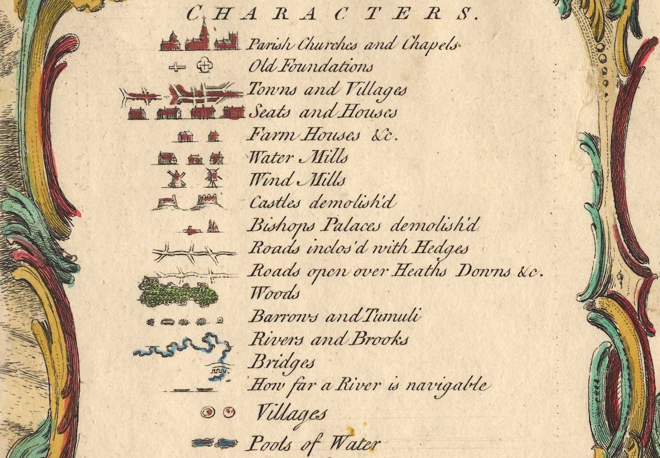
Key to Characters used within Isaac Taylor's Map of Hampshire including the Isle of Wight, Augst 20th 1759
Place 228
Place numbered 228, of Moundsmore (Moundsmere)
Gentleman; Thomas Hall Esq.
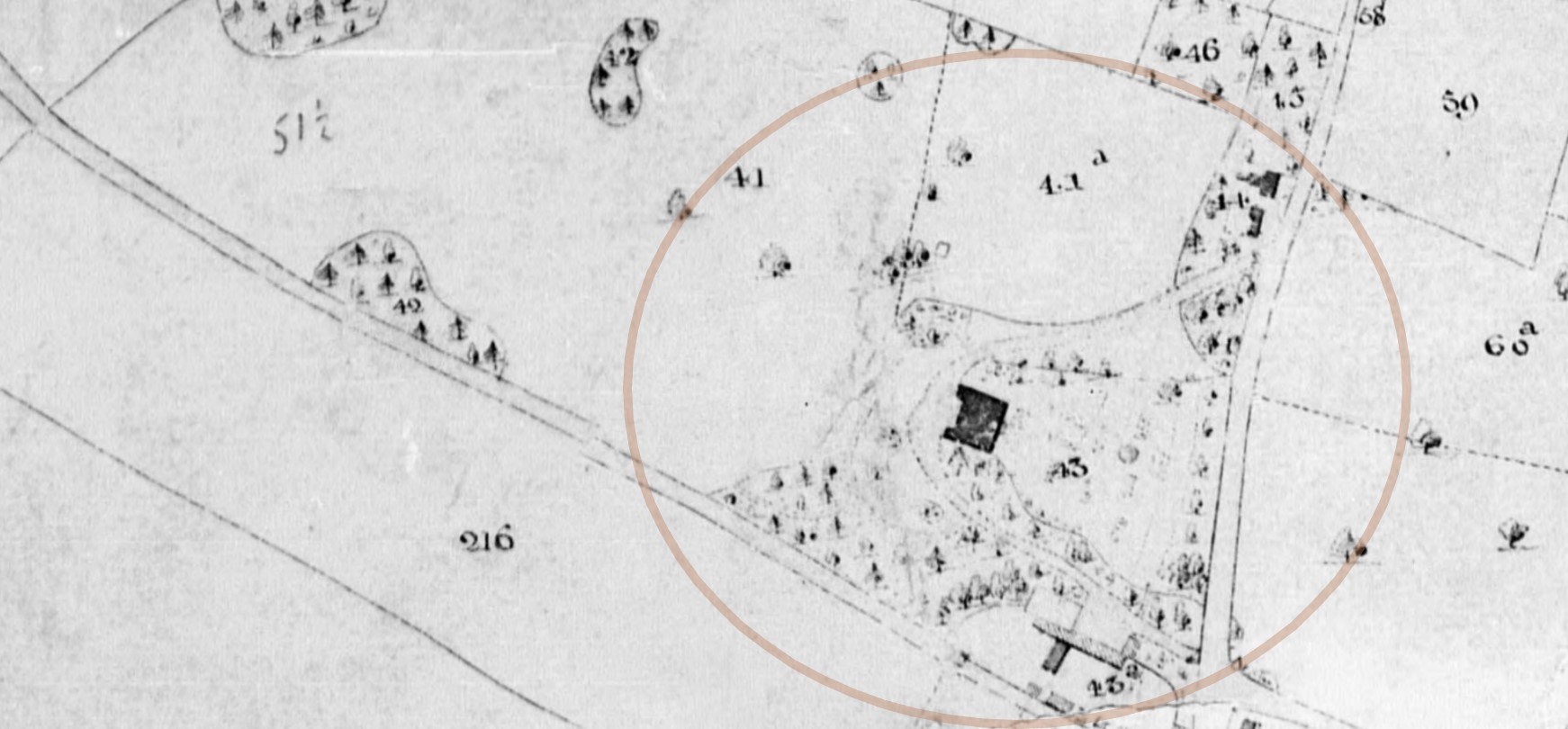
I have found place 228 in Section 65 bottom left square, above the join in the map.

It is near Preston Candover, and is part of that parish.
Unfortunately, as you will read there are six manors, and therefore presumably six potential residences to match 228. How to resolve which one?
British History Online has an article about Preston Candover. Extracts below.
The parish of Preston Candover, containing 3,457 acres, lies on comparatively low ground, south of the high country round Farleigh Wallop and Nutley, and north-west of that which rises to Wield and beyond Wield to Medsted. The ground rises generally from west to east, the greatest height, 500 ft. above the ordnance datum, being reached in the north-east near Moundsmere Farm.
Moundsmere Farm, lying on the downs in the north-east, is the most interesting spot in the parish. When the property of Southwick Priory, including the manor of Moundsmere, passed to Winchester College by exchange with Henry VIII in 1543, the farmstead was in the very next year used as a sick-house for the Winchester scholars who were stricken down by the plague that visited Winchester in 1544. Thus new buildings appear to have been run up round the farm-house during that year, and a number of scholars were sent there both in the autumn and winter terms. In 1554, on the occasion of another outbreak of the plague, scholars were again sent to Moundsmere, and, probably by means of a certain sum over from Queen Mary's largess given on her bridal visit to the college, 'the chyldren's hows at Mouseberie (sic) for their comfort in tyme of siknes' was repaired and the barn was fitted with bed-places and windows for their reception. Mr. Kirby, in his Annals of Winchester College, quotes an interesting clause inserted after this date in all successive leases of the demesne land of the manor, reserving to the college 'the new buildings adjoining the manor house' with all new rooms that might hereafter be built for such time only as the warden, scholars, schoolmasters, clerks, or servants of the college should 'resort, come, and remain there for the avoiding of the plague or any such pestilential sickness.' But although the tenant of Moundsmere Farm was thus obliged to receive sick scholars at any time, when the plague of 1666 made its appearance in Winchester the sick scholars instead of being sent to Moundsmere were sent to a farm-house at Cranley, and presumably from that time the tenant of Moundsmere escaped his obligation.
MANORS
In PRESTON CANDOVER at the date of the Domesday Survey there were six separate estates, five of which were owned by the Conqueror's followers who had replaced the Saxon owners, whilst the sixth was still held by a Saxon priest, the pre-Conquest owner. Of these estates William Mauduit had one which in the Confessor's time had been held as two manors; Ralf de Mortimer and his under-tenant Oidelard held the second which had before belonged to Cheping; Hugh de Port, whose under-tenant was Anschitel, held the third which had been a portion of the possessions of Earl Godwin; clerks, or priests, had the fourth which had been the land of Alvric; Cheping had the fifth which was before held by Sberne of Queen Edith; and lastly, Edwin the priest held the sixth of King William as he had held it of King Edward.
In the June of 1495 Richard More died in possession of Preston Candover manor known later as PUREFOYS. It is difficult to determine his title to this property unless it was conveyed to him by William Skulle, or unless some land in Preston Candover passed to the Mores from the Horwoods.
The manor of Richard More, however, was not held either of the Camoys family, or of the lords of Bradfield, as was Horwoods manor, but of Lord St. John. Katherine, Richard More's widow, held the manor for life under her late husband's will, with remainder to her son John More, then aged twenty, or in default of male heirs, the property, according to the settlement, was to remain to Isabel Williams, wife of John Williams, among several other heirs.
There is no mention of John More being in possession of Preston Candover, but the property seems to have descended or been conveyed to Isabel Williams.
Her son, Reginald Williams, next held the property, whose son John, dying without issue, was succeeded by his brother Nicholas.
The title of Nicholas to the estate was disputed in Elizabeth's reign by Walter Mayhew, a husbandman of Rotherwick, who claimed the manor in right of his wife Elizabeth, who, according to Walter Mayhew's statement, was a daughter of John More, son of that Richard More who had died in 1495 seised of the manor of Preston Candover.
The defendant traced his title to his grandmother, Dame Isabel Williams. The matter was, about 1566, referred to the arbitration of the bishop of Winchester and Henry Wallop, and evidently Nicholas Williams won his case, as Walter Mayhew in 1579 relinquished his claim to Francis Perkins, who by marriage with a daughter of Nicholas Williams had become lord of the manor. He died in 1617, and his son, a Roman Catholic Royalist, in his old age suffered sequestration of his estate for recusancy under the Commonwealth. The family held the manor until 1733, when the fourth Francis Perkins, of Preston Candover, who had married the famous Arabella Fermor, sold it to Thomas Hall for £1,700. Elizabeth granddaughter of Thomas Hall, heiress of her brother, brought the manor to George Purefoy Jervoise, who bequeathed it to his niece, Elizabeth Fitzgerald, from whose grandson, Captain Richard Purefoy Purefoy, it was purchased in 1905 by Mr. J. C. A. Hall and Mr. C. Wade, the present owners.
{Present owners at the time of the BHO article}
Of William de Pont de l'Arche, in 1381, the priory of Southwick held the manor later known as MOUNDSMERE.
In the year 1290 the prior of Southwick's manor of Candover was valued at £3 11s. 7d. In the thirteenth century Robert de Pont de l'Arche confirmed the grant of his father of the church with the manor of Candover (which comprised five hides of land with wood and meadow) to the canons of Portchester, and this grant was again confirmed by Henry III, Edward II, and Richard II.
Confusion
The manors are not named, but it appears to me that Thomas Hall was the purchaser of the estate that was disputed, which later passed to George Purefoy Jervoise, but separately the priory of Southwick held the manor later known as MOUNDSMERE. Are they one in the same, in different periods?
 Another Old Hampshire Mapped - Milne 1791 Moundsmore, Preston Candover, Hampshire
Looking at the above extract from a '1 inch to 1 mile' map of Hampshire surveyed by Thomas Milne, published by William Faden, 1791, known as Milne's Hampshire 1791 on the Old Hampshire Mapped website. Moundsmore approximately matches the position of Moundsmore 228 on Taylor's 1759, map, 32 years earlier. However, Thos Hall Esqr appears to have a property closer to the centre of Preston Candover.
Reverting to the Taylor's map, but Section 55 to see if there is another numbered place in Preston Candover. There is some overlap on the map tiles, so 228 can be seen in this image as well.
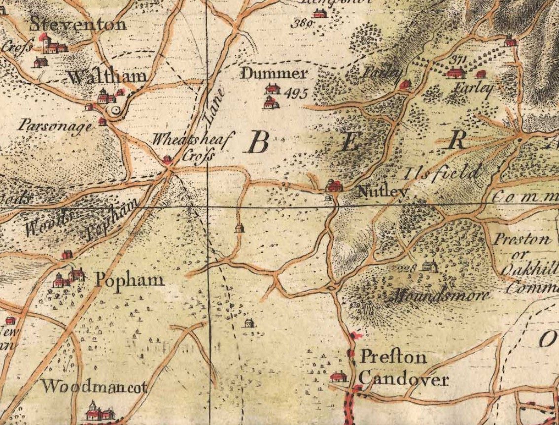
It is evident that there is not another numbered place in Preston Candover despite the one time presence of six manors in the area.
Tithe Apportionment and Maps.
The history of the manor from Thomas Hall to George Purefoy Jervoise brings us to the timeframe of the Tithe Apportionment and Maps. Not a normal place to look as there is almost a century time difference, but as we have a succession which probably breaches that time difference, there is a chance.
George Purefoy Jervoise is by the time of the Tithe Map, 1838, a very extensive landowner.
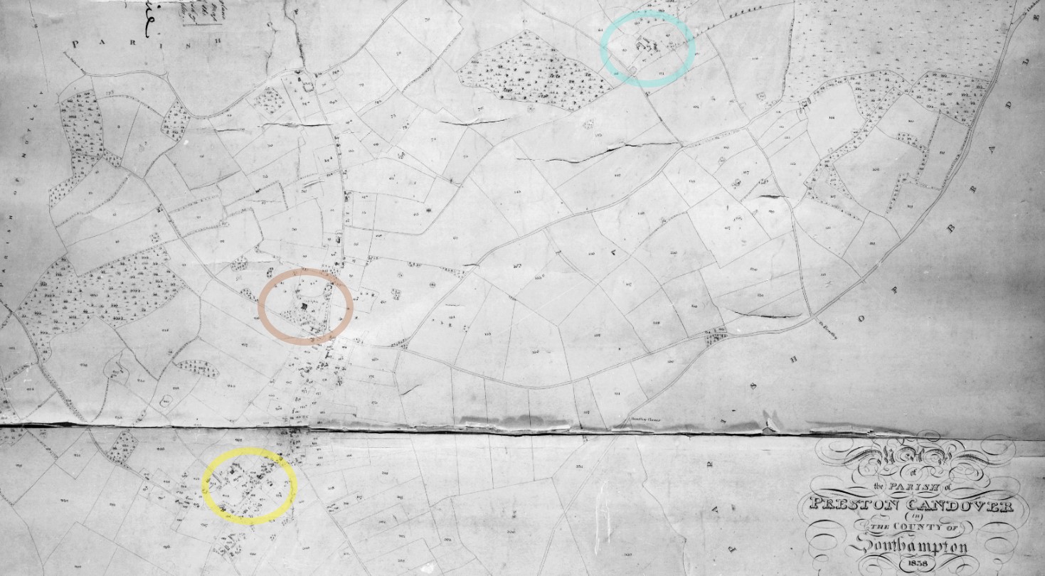
George Purefoy Jervoise has interests in properties in the yellow circle, in the centre of Preston Candover, and the blue circle, probably Moundsmere Farm. Not in the brown circle which is described as Mansion and Pleasure Grounds, in the approximate location of Preston House.
The yellow circles pick out just some of the larger properties of which George Purefoy Jervoise is the landowner, but is not identified as the occupier.
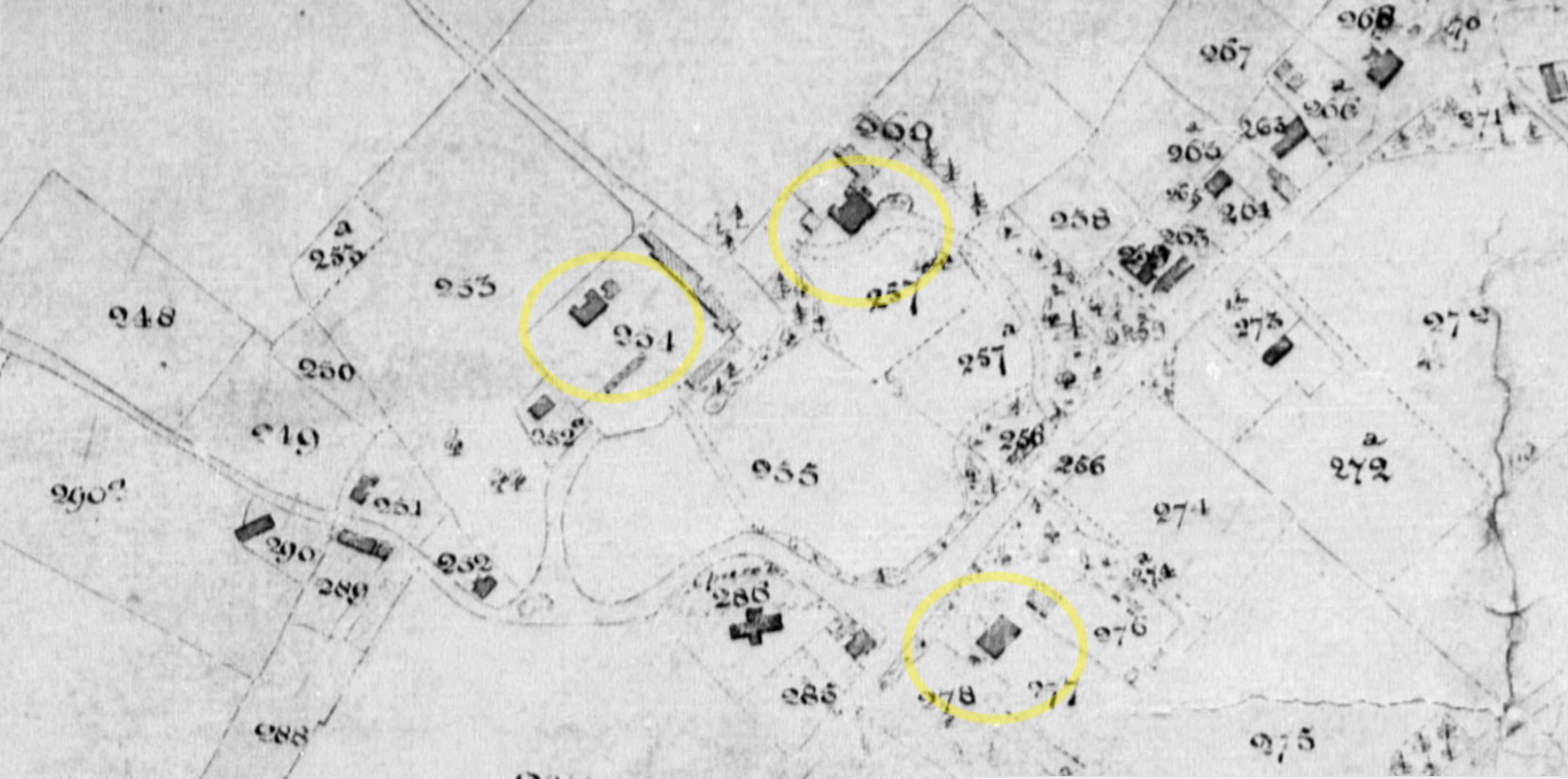
 OS 25" Old Map Preston Candover - Click the map to open the source in a new window
The Ordnance Survey 25" Map of Hampshire and Isle of Wight XXXIV.3, Revised: 1894, Published: 1896 identifies the properties as Manor Farm, North Hall and South Hall, all circled in yellow. Preston House is circled in brown, but is under different ownership.
Plot 43, Mansion and Pleasure Grounds, Landowner and Occupier, Charles Edmond Rumbold. I think this is Preston House.
This plot, 88, is the most likely place called Moundsmore, aka Moundsmere.
| Landowner Party | G P Jervoise |
|---|---|
| Relationship to Landowner | Lessee |
| Landowner Organisation | Winchester College |
| Occupier | Elizabeth Pitt |
| Parish | Preston Candover |
| County | Hampshire |
| Original Date | 22nd March 1839 |
| Description of Land | House Gardens Yards and Buildings |
| Quantities In Statute Measure | 1,2,13 |
| Plot | 88 |
It appears that Thomas Hall Esq or his successors had interests in the properties in Preston Candover and in Moundsmere.
The positioning on the various maps favor Place 228 and Plot 88 being the same place.


Current Notes
Google Maps Satellite View of Moundsmere Farm, home to Moundsmere Estate Management, and the much more recent Moundsmere Manor, to the south.
An extract from Hampshire Gardens Trust
After the dissolution of the monasteries, the manor of Moundsmere became part of the dowry first of Anne of Cleves, and then Catherine Howard. After Catherine Howard’s death Henry VIII granted it to Winchester College in part exchange for other manors. There has been a farmhouse, (Moundsmere Farm), in the manor since the 17th century, but the present Moundsmere Manor house and gardens were not built until 1908-09. Both the house and gardens were designed by Reginald Blomfield for Wilfred Buckley, a highly successful businessman returning to England from America.
Moundsmere Manor - Basingstoke - Parks & Gardens (parksandgardens.org)
Moundsmere Manor, Axford | Notable Hampshire Country houses
Historic England Listing for the Farm House - Grade II
Early C18, early C19. L-shaped 2-storeyed house with later one-storeyed extensions. Main front (south-east) of 3 windows (may once have been symmetrical of 5). Steep hipped tile roof. Stucco walling with first-floor band, plinth. Sashes in exposed frames. Half-glazed door in old frame, within a small modern gabled porch. The elevations within the angle have 3 upper and 2 lower sashes and one ground-floor casement; there is a corner porch with an old 6-panelled door. A small garden space is enclosed by a low brick wall and cast-iron rails.
Moundsmere Manor is also listed, Grade II.
Place 371
Place numbered 371, Hussbourg, or Farley from map.
Gentleman; Rt Hon Earl of Portsmouth.
I have found place 371 in Section 65 middle left square, above the join in the map.
Starting with the Rt Hon Earl of Portsmouth.
Earl of Portsmouth is a title in the Peerage of Great Britain. After the death of Louise de Kérouaille, Duchess of Portsmouth (c. 19 August 1673 - 14 November 1734), it was created in 1743 for John Wallop, 1st Viscount Lymington, who had previously represented Hampshire in the House of Commons. He had already been created Baron Wallop, of Farleigh Wallop in Hampshire (in the County of Southampton), and Viscount Lymington, in 1720, also in the Peerage of Great Britain.
The second earl was the son of Catherine Conduitt, whose mother was Catherine Barton, half-niece of the eminent mathematical scientist Sir Isaac Newton. The earls of Portsmouth therefore are direct descendants of Isaac Newton's mother, and three of the earls have been named after Newton. The earls were in possession of a large trove of Newton's personal papers, until they were auctioned in 1936. Those documents are commonly known as the "Portsmouth Papers".
John Wallop, 2nd Earl of Portsmouth (29 June 1742 – 16 May 1797), styled Hon. John Wallop from 1743 to 1749 and Viscount Lymington from 1749 to 1762, was a British nobleman.
He also had interests in Hurstbourne as well as Farley
Heritage England
The manor of Hurstbourne, although owned by the Crown, was essentially under religious control until the Dissolution. It formed part of a larger estate, including Hurstbourne Tarrant, St Mary Bourne, and Hurstbourne Priors, which was recorded by the Domesday survey as belonging to the Bishop of Winchester. Manorial rights were held by the prior of St Swithin's who in 1332 was given a licence to impark and enclose his woods to create a deer park which probably covered much the same area as the present (late C20) one. The manor house, referred to also as the Priory and later as the Grange, stood in the valley on the Bourne Rivulet. Following the Dissolution, the manor passed to the Crown but was eventually sold in 1558 to Sir Robert Oxenbridge. His grandson, also Sir Robert, again sold it, `with orchard, gardens and the park called Hursbourn containing by estimation three hundred and fifty acres' (Wilkinson 1861) to Sir Henry Farley of Farley Wallop. Sir Henry died in c 1678 and was succeeded by his sons Henry and then John. John's second son, also John and later to become Viscount Lymington and first Earl of Portsmouth, inherited in 1707 at the age of seventeen.
Farleigh Wallop House (formerly listed as Farleigh House)
1731, and 1935. On an old site, a rebuilding of 1731, incorporating an earlier structure burnt in 1661, with a reconstituted west front by H S Goodhart-Rendel. Two storeys and attic and basement. The east (1731) front is symmetrical, with an angular centrepiece, 2.3.2 windows. Hipped slate roofing, with 2 flat-roofed dormers on each side and 2 on the diagonal faces of the octagonal pyramid roof of the centre; moulded cornice. The main wall is of squared flint, the centrepiece of stone ( ) in fine ashlar; stone dressings include flush quoins, architraves (the upper plain but moulded in the centrepiece, the lower with cornice, keystone, and panel, with rusticated arches in the centre) plinth, and carved coat of arms above the central French window.
The Gentlemen's List refers to Hussbourg or Hufsbourg for place 371

I have not yet found any reference to Hussbourg or Hufsbourg, or variations in relation to either the Earl of Portsmouth or Farley / Farleigh. A possibility is that Hussbourg is a mis-pronouncing or mis-spelling of Hurstbourne, or an earlier version of the name. It could be that, for instance, on the next line, Rt Hon Ld V Palmerston Broadlands, where Broadlands is the family seat, perhaps the same applies to the Earl of Portsmouth, and others.
I have also not yet found any reference to the name change from Farley to Farleigh, but am reasonably happy that they are one in the same, particularly as they are pronounced the same. There is however reference above to Farleigh House changing name to Farleigh Wallop House. Wallop being the oft used surname of Earls of Portsmouth.


X, Y, & Z
Families -- Dynasties
Gentlemen's Families and Dynasties
When going through the identification of the location of places attached to the Gentlemen's List I would try to research that the person matches the place, thereby increasing the validation of the found location. In so doing family histories are often exposed, to some extent. There are a lot of properties which are linked to the same family or branches of the same family, or dynasty, not always with the same surname.
In this section I will record some of the information I find out about the Places numbered against the Gentlemen's List on the Taylor's Map of Hampshire 1759 and the links to joined families and dynasties. I will start with a relatively easy one, the Mill Family.
Well, I thought it would be easy, but it turned out to be more complicated than I thought.
Mill
Mill Family and Dynasty
Starting reference is made to Taylor's Map of Hampshire 1759
An extract of the Gentlemen's List, surname M.
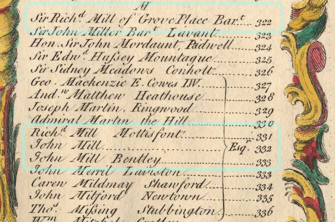
Sir Richard Mill of Grove Place Bart is associated to Property 322
Richard Mill Esqr., Mottisfont is associated to Property 331
John Mill Esqr., is associated to Property 332
John Mills Esqr., Bentley is associated to Property 333.
As it stands at this stage there is no link between these four people, other than sharing the same surname, and the County of Hampshire. Here we explore the records to establish any links, if there are any to be found.
Starting with Richard Mill Esqr of Monttisfont.
Explore - Information and Records
Richard Mill Esqr., Mottisfont is associated to Property 331
Property 331 appears to be Mottisfont Abbey.

Historic England's official listing has reference both to Mottisfont Abbey and Richard Mill.
On the death of the eighth Lord Sandys and the extinction of the title in 1684, Mottisfont passed to his nephew Sir John Mill. Sir John's second son, Richard, who succeeded in 1706, altered the Tudor house to its present form, carried out planting in the park, and also appears to have been the first to use the name Mottisfont Abbey. The property descended through the Mill family, being inherited in 1884 by Mrs Vaudrey Barker-Mill.
History of Mottisfont Abbey by National Trust
The Mill family transformed Mottisfont into the building and landscapes recognisable today. By the 1730s, Lord Sandys’ Tudor house was beginning to look old and dated, and Sir Richard Mill started modernising the house. He knocked down the outer courtyards and re-modelled the main house, adding the pediment and the projecting bays to create the house we see today.
MILL, Sir Richard, 5th Bt. (?1689-1760), of Woolbeding, nr. Midhurst, Suss.
Family and Education
b. ?1689, 2nd s. of Sir John Mill, 3rd Bt., of Woolbeding, Suss. by Margaret, da. and h. of Thomas Grey of Woolbeding. educ. St. John’s, Oxf. 12 Mar. 1708, aged 18. m. 12 Mar. 1713, Mary, da. of Robert Knollys of Grove Place, Nursling, Hants, 4s. 5da. suc. bro. John 1706, Thomas Knollys (s. of Henry Knollys) at Grove Place 1751.
Born about 1689, 2nd son of Sir John Mill, 3rd Baronet, of Woolbeding, Sussex, and Margaret Mill nee Grey, daughter and heir of Thomas Grey of Woolbeding.
Married 12 March 1713 daughter of Robert Knollys of Grove Place, Nursling Hampshire. They had four sons and 5 daughters.
Succeeded his brother John Mills 1706.
MILL, Sir Richard, 6th Bt. (c.1717-70), of Montisford, Hants.
Family and Education
b. c.1717, 1st s. of Sir Richard Mill, 5th Bt., M.P., by Margaret, da. of Robert Knollys of Grove Place, Nutshelling, Hants. educ. New Coll. Oxf. 1735. m. Aug. 1760, Dorothy, da. and h. of Richard Warren of Redcliff, Som., 2da. suc. fa. 16 May 1760.
Born c. 1717, first son of Sir Richard Mill, 5th Baronet, MP and Margaret Mill nee Knollys who was the daughter of Robert Knollys of Grove Place, Nutshelling, Hampshire. (Nutshelling is now known as Nursling)
Married in August 1760 to Dorothy, daughter and heir of Richard Warren of Redcliff, Somerset, They had two daughters.
He succeeded his farther on 16 May 1760.
Montisford and Grove Place linked my marriage

Baptism record extracted from the Parish Records of Woolbeding, Sussex, England.
Richard the son of Sr Richard Mill & Margaret his wife was born Novombr the 25th & baptised the 27th of Novombr
Will of Sir Richard Mill of Mottisfont
An exploration of his will and the Beneficiaries mentioned therein. Followed by expanding the research to include him and his family, together with any links to other Biddlecombe families in the series.
This will, and its transcription are part of the research into the Mill family and dynasty.
Will of Sir Richard Mill
Sir Richard Mill of Mottisfont, Hampshire, his will
The starting place for this article is his Last Will and Testament as found in the The National Archives.
Will of Sir Richard Mill of Mottisfont , Hampshire
Catalogue description
Will of Sir Richard Mill of Mottisfont , Hampshire
Reference: PROB 11/956/136
Description: Will of Sir Richard Mill of Mottisfont , Hampshire
Date: 20 March 1770
Held by: The National Archives, Kew
Legal status: Public Record(s)
Closure status: Open Document, Open Description
This is evidently a very long Last Will and Testament.
My initial transcription of the above will.
Sr Richard Mill Bart
In the Name of God Amen
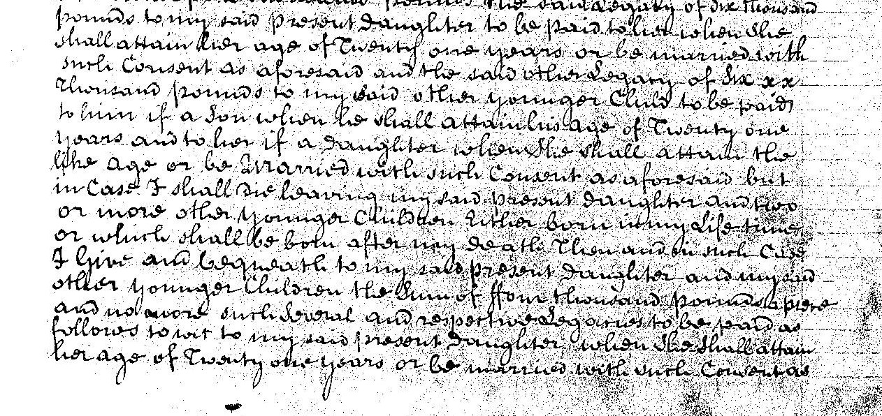
I Sir Richard Mill of Mottisfont in the County of Southampton Baronet being of sound and disposing Mind do make ordain and publish this my Last Will and Testament in manor and form following that is to say In the first place ratify and confirm the Settlement or xxx made by me previous to and in a Consideration of my Marriage with my loving wife Dorothea Will and do direct the same to be xxx observed and xxx into xxx xxx to the time xxx and xxx as thereof and I do Give and bequeath to my said Wife One thousand pounds to be paid to her within one year next after my death over and above what She is or will be xxx to by such Marriage Contract and I also Give and bequeath to my siad wife for and x during her widowhood all things Jewells watch trinkets x and other xxx of her person and upon her death or Second Marriage of my Wife which shall first happen
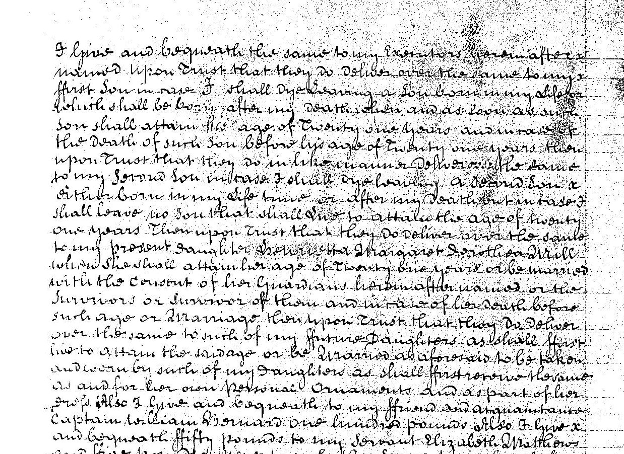
I Give and Bequeath the same to my Executors herein after named Upon Trust that they do deliver over the same to my first Son in case I shall dye saving a Son born in my Life for which shall be born after my death xxx and as soon as such Son shall attain his age of Twenty one years and in case of the death of such son before his age Twenty one years then upon Trust that they do in like manner xxx the same to my second Son in case I shall dye having a second Son either born in my life time or after my death but in case I shall leave no Son that shall Live to to attain the age of twenty one years Then upon Trust Wish they do deliver over the same to my present daughter xxx Margaret Dorothea Mill when She shall attain her age of Twenty one years or be married with the consent of her Guardians herein after named or the Survivors or Survivor of them and in case of her death before such age or Marriage then upon Trust that they do deliver over the same to such of my future Daughters as shall first live to attain the said age or be married as aforesaid to be taken and xxx by such of my daughters as shall first survive the same as and for her own personal Ornaments and as part of her xxx
Also I Give and Bequeath to my friend and and acquaintance Captain William Barnard One hundred pounds
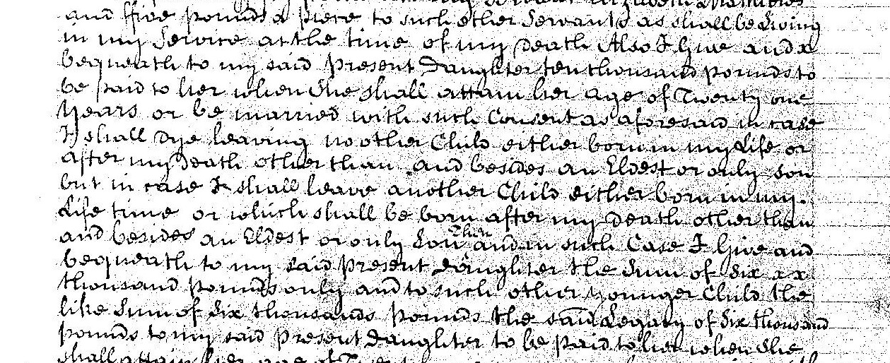
Also I Give and Bequeath fifty pounds to my Servant Elizabeth Mathews and five pounds x xxx to such other Servants as shall be Living in my Service at the time of my death Also I Give and Bequeath to my said present Daughter Ten Thousand pounds to be paid to her when she shall attain her age of Twenty one Years or be married with such Consent as aforesaid in case I shall dye leaving no other Child either born in my Life or after my Death other than and besides an Eldest or only Son but in case I shall leave another Child either born in my Life time or which shall be born after my death other than and besides an eldest or only Son then and in such Case I Give and Bequeath to my said present daughter the Sum of Six thousand pounds only and to such other younger Child the like Sum of Six thousand pounds said xxx of Six thousand pounds to my said present Daughter to be paid to her when she shall attain her age of Twenty one years or be married with such Consent as aforesaid and the said other xxx of Six thousand pounds to my said other younger Child to be paid to him if a Son when he shall attain his age ot Twenty one years and to her if a Daughter when she shall attain the age or be married with such Consent as aforesaid but in Case I shall die leaving my said present Daughter and xxx or more other younger Children Either born in my Life time or which shall be born after my death
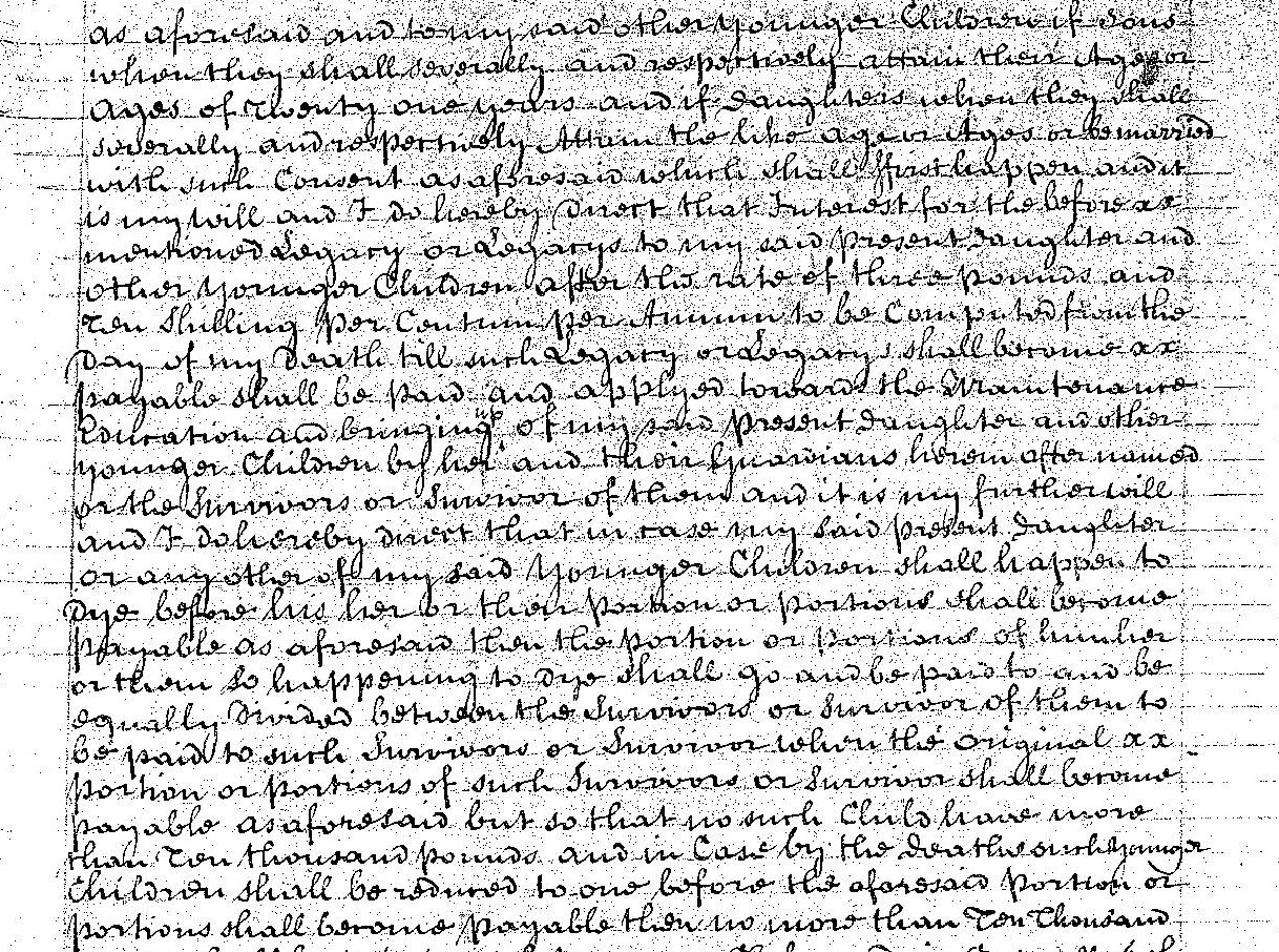
Then and in such Case I Give and Bequeath to my said present Daughter and my said other younger Children the Sum of four thousand pounds a xxx and no more such xxx and xxx xxx to be paid as follows so xx to my said present Daughter when she shall attain her age of Twenty one years or be married with such Consent as aforesaid and to my said other younger Children if Sons when they shall xxx and xxx attain their xxx Ages of Twenty one years and if Daughters when they shall xxx and xxx attain the like age or be married with such Consent as aforesaid which shall first happen and it is my Will and I do hereby xxx that xxx for the before mentioned xxx or xxx to my said present Daughter and other younger Children after the of three pounds and ten shilling per xxx per Annum to be Computed from the day of my death thill such xxx or xxx shall xxx payable shall be paid and applied toward the Maintenance Education and bringing up of my said present Daughter and other younger Children by her and their Guardians herein after named or the Survivors or Survivor of them and it is by further Will and I do hereby direct that in case my said present Daughter or any other of my said younger Children shall happen to dye before his her or their portion or portions shall becombe payable as aforesaid then the portion or portions of him her or them so happening to dye shalll go and be paid to and be equally divided between the Survivors when the original portion or portions of such Survivors or Survivor shall become payable as aforesaid but so that no such Child have more than ten thousand pounds and in Case by the deaths such younger Children shall be xxx to one before the aforsaid portion or portions shall become payable then no more than ten thousand pounds shall be paid to such younger Child and in Case all such younger Children shall happen to dye before their or any of their portions shall become payable as aforesaid then the said Sums or any of them shall not be paid but in such Case my Manors Messuages Lands and Estates herein after xxx to the payment thereof shall from xxx forth be discharged and acquitted those from for the benefit of the person or persons to whom the said Manors Messuages Lands and Estates shall from time to time xxx and belong
Also I Give and Bequeath to my three Executors herein after named One hundred pounds a piece
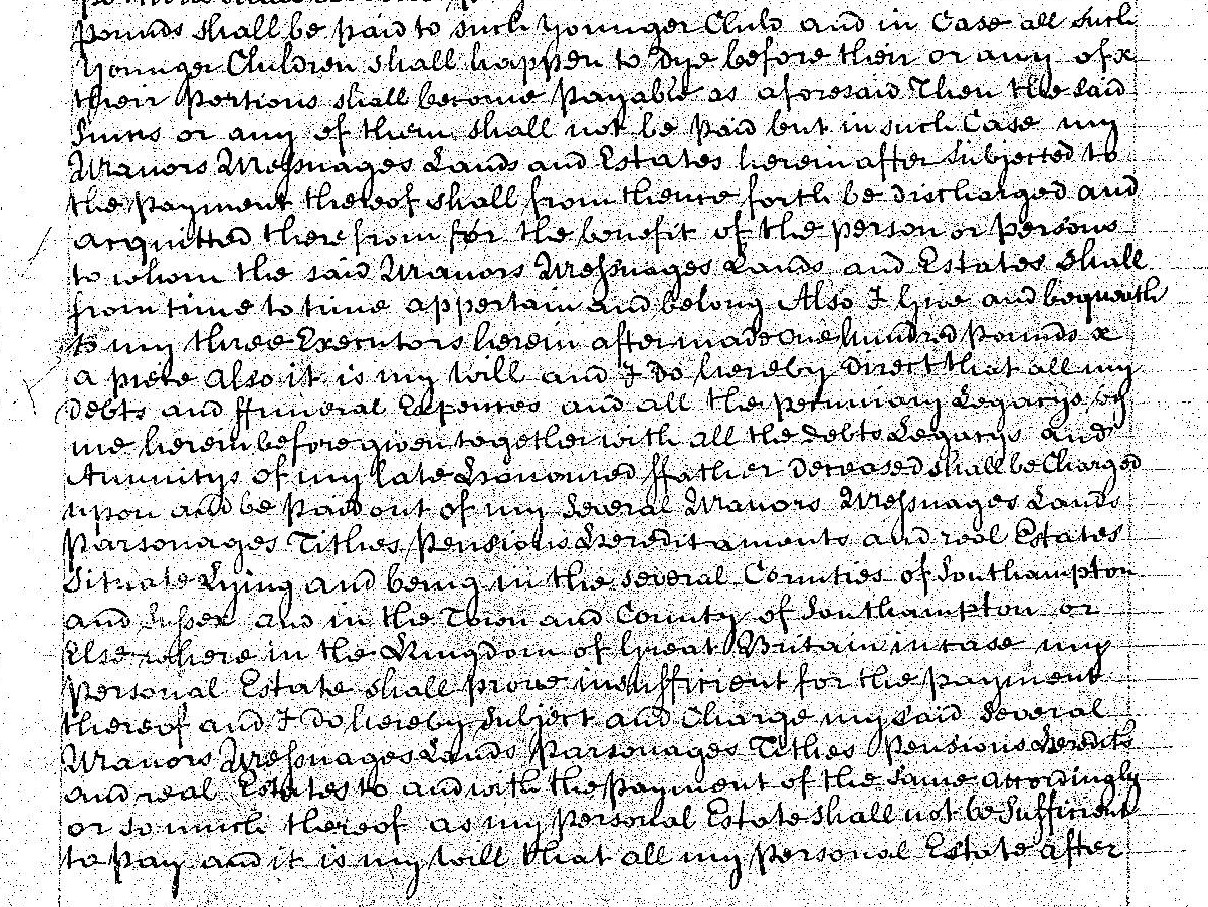
Also it is my Will and I do hereby direct that all my Debts and funeral Expenses and all the xxx xxx by me herein before given together with all the Debts xxx and Annuities of my late xxx father xxx shall be Charged upon and be paid out of my Several Manors Messuages Lands Parsonages Tithes Pensions xxx and xxx Estates situate & Lying and being in the several Counties of Southampton and Sussex and in the Town and County of Southampton or Elsewhere in the Kingdom of Great Britian in case my personal Estate shall prove insufficient for the payment thereof and I do hereby subject and charge my said several Several Manors Messuages Lands Parsonages Tithes Pensions Hereditaments and xxx Estates to and with the payment of the same accordingly or so much thereof as my personal Estate shall not be xxx to pay and it is my Will that all my personal Estate after deducting the Costs of by Executors in the Execution of this my Will shall be so apply in the first place xxx and xxx my xxx Manor of Southwells otherwise xxx together with the Mansion House called Grove Place and all other Buildings farms Lands Meadows xxx and xxx xxx to the said Manor belonging in the said County of Southampton and also all my xxx xxx furniture plate xxx and things all xxx part therein of my Executors and to be at Liberty to sell or not sell as they in their discretion shall think fit but if sold then it is my Will and direction that the Money to arise thereby shall be applied towards discharging the Disbursements aforesaid in aid of my xxx Estates Subject as aforesaid to the payment thereof.
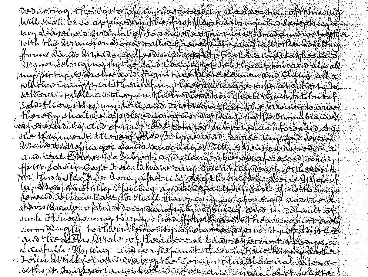
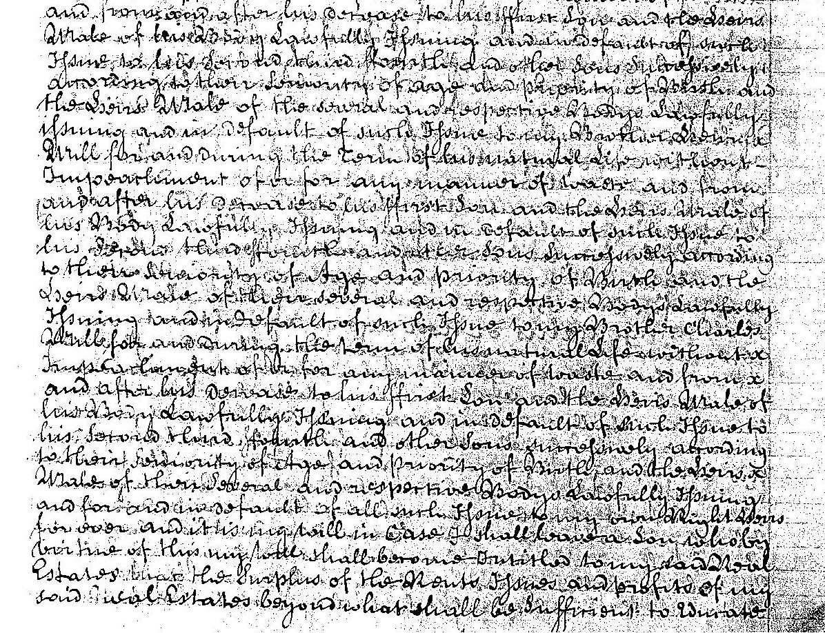
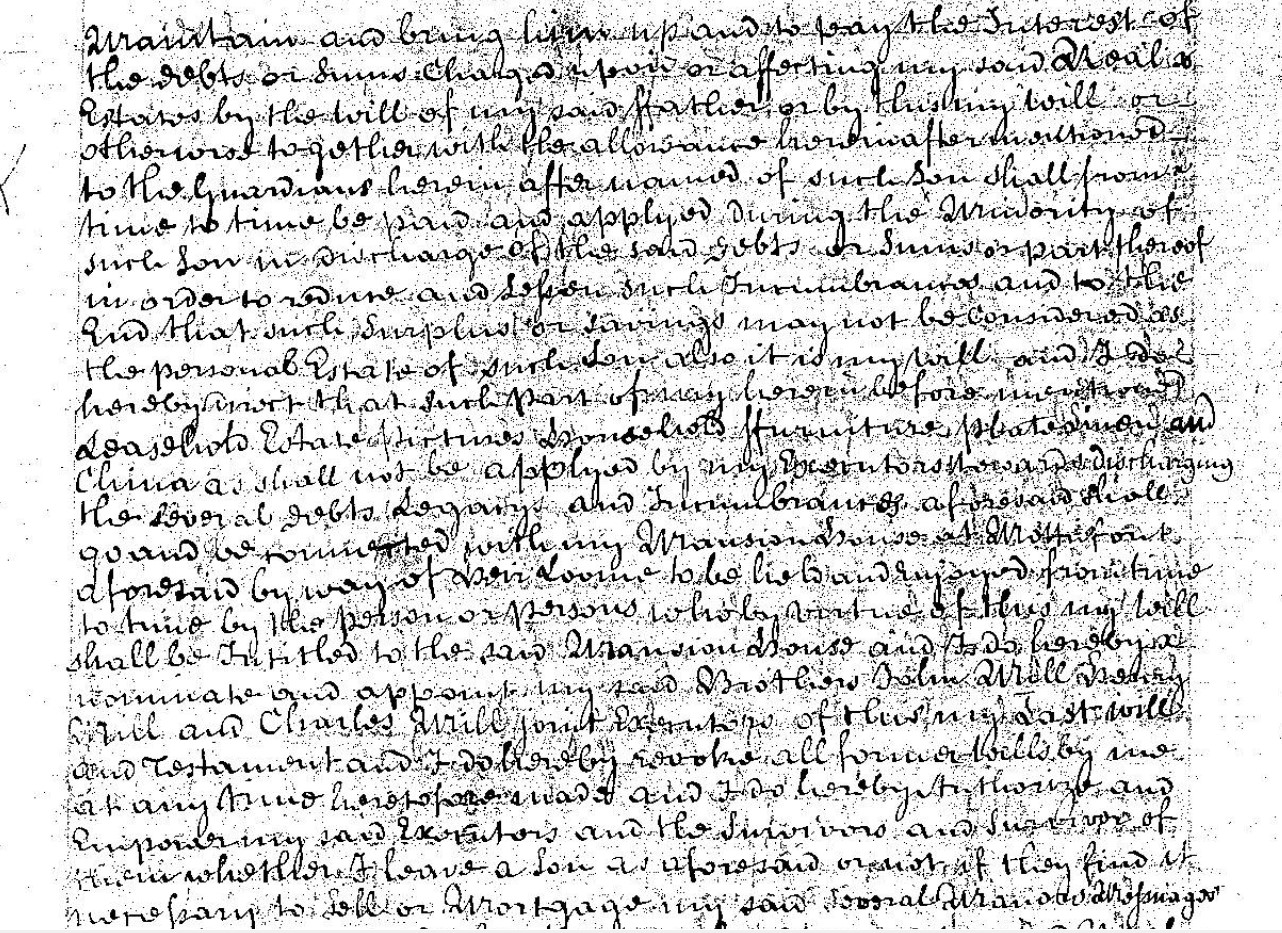
Also I Give and devise my said Several Manors Messuages Lands Parsonages Tithes Pensions Hereditaments and xxx Estates so Subject and intangible as aforesaid to my first Son in Case I shall have any Son at my death or there xxx Son that shall be born after my death and the xxx xxx of his Body dutifully xxx and xx of xxx xxx my xxx Son in Case I shall have any as aforesaid and the xxx xxx of his Body xxx xxx and in default of such xxx my xxx xxx xxx xxx xxx and the xxx xx of their xxx xxx xxx Lawfully xxx and for xxx of xxx xxx Brother John Mill for and xxx the Town of his xxx xxx without xxx of xx for and xxx of waste and xxx xxx xxx his xxx to his first Son and to xxx Make of his xxx Sons xxx xxx and in xxx xxx xxx to his xxx xxx xxx xxx xxxxxxxxxxxxxx the xxx Make of the xxx and xxx xxx Lawfully issuing and in default of such xxx xxx xxx Will forward during the term of his natural Life xxx xxx of or for any mannor of xxx and from xxx xxx xxx xxx first Son and the xxx xx of his Body Lawfully xxx and in default of xxx xxx his xxx third xxx the and xxx Sons xxx to xxx xxx of Age and xxx of Birth and the xxx xxx of the xxx and xxx xxx xxx xxxx my Brother Charles Mill for and during the term of his natural Life without xxx xxx of or for any xxx of waste and from and after his demise to his first Son xxx to xxx xxx of his Body Lawfully xxx and in default of such xxx his second third fourth and other Sons xxx according to their xxx of Age and priority of Birth and the xxx xxx of their xxx and xxx Bodys Lawfully xxx and for and in default of all such xxx xx xx xx for over and it is xxxx in Case I shall have a Son wholly xx time of this my Will shall xx xx to my said Real Estates that the Surplus of the Rents Issues and Profits of my said xxx Estates beyond what shall be xxx to xxx Maintain and bring him up and to pay the Interest of the debts or Sums Charged xx or after xx said Real Estates by the will of my said father or by this my Will or otherwise together with the allowance hereinafter xxx xxx to the Guardians herein after named of such Son shall from time to time be paid and applied during the Minority of such Son in discharge of the said debts or Sums as part thereof in order to xxx and xxx such Disbursements and to this End that such Surplus or savings may not be considered as the personal Estate of such Son
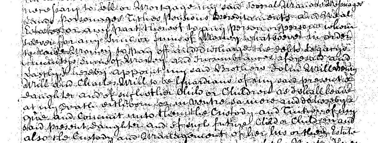
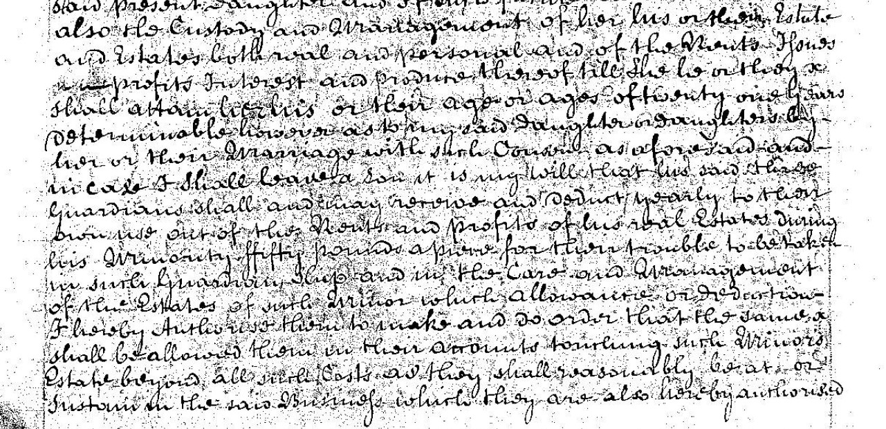
Also it is my Will and
Old Template material pertaining to Christopher Biddlecomb. Not relevant.
My initial transcription of the above will.
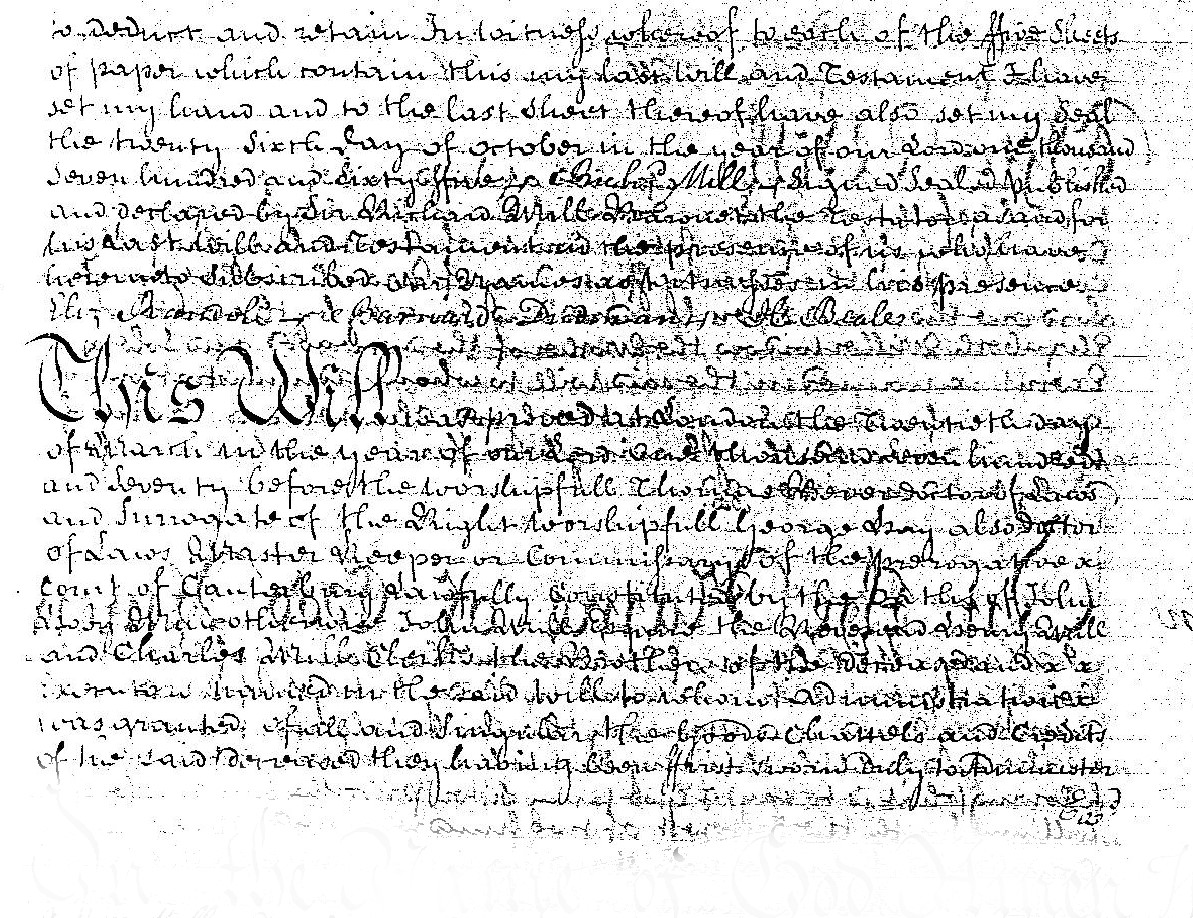
In the name of God Amen:
This fifteenth day of July in the year of our Lord One thousand six hundred Forty and seven I Christopher Biddlecomb of Hightowns in the parish of Ringwood in the County of South a yeoman being sick in body, but of good and perfect memory thanks be given Almighty God do make and ordain this my last will and testament as followeth. First I Commit my Soul into the hands of Almighty god, and my body to be buried in the parish Church of Ringwood.
Item I give to the poor people of Ringwood twenty shillings.
Item I give to my Son John Biddlecomb twenty pounds lawful money of England, {....}.
I give to my said Son John Biddlecomb sixteen pounds being part of the debt of Edward Riffen unto me by bond, and which sixteen pounds my said son John Biddlecomb hath {.........} {were......}.
Item I gift to my Grand children Elinor Dantor Iornd Dantor and Margartt Dantor and Richard Dantor and to xxxx and xxxx of them five pounds lawfull money of England.
Item I give to my Grandchild Thomas Biddlecombe five pounds of lawfull money of England.
Item I give to my Grandchildren Richard Biddlecombe and Elizabeth Biddlecombe and to {.....} and either of them five pounds lawfull money of England
Item I give to my Daughter Margarett Rook twenty shillings lawfull money of England.
All the other of my goods and chattels moveable and nonmoveable my debts and bequests paid.
I give and bequeath unto Richard Biddlecomb my Son whom I do make and ordain my full and sole Executor in and by this my last will and testament
I witness whereof I have hereunto set my hands and seal and published this my last will and testament the day and year above written in the {.....} of Christopher Biddlecomb his sign
Christophor Iun his sign
Nicholas Bounds
| Date of Will | 15 July 1647 |
| Date of Codicil | None |
| Date of Proving | 26 May 1649 |
People in the Will of Christopher Biddlecombe of Hightown
From the above it appears that Christopher Biddlecomb made provision for the following family, in addition to the poor people of Ringwood.
| Name | Stated relationship | Assumed relationship | Assumed previous name | Place | Notes |
|---|---|---|---|---|---|
| poor people of Ringwood | |||||
| John Biddlecomb | Son | ||||
| Richard Biddlecomb | Son | ||||
| Margarett Rook | Daughter | Margarett Biddlecomb | |||
| Elinor Dantor Iornd Dantor and Margartt Dantor and Richard Dantor | Grand children | ||||
| Thomas Biddlecomb | Grand child | ||||
| Richard Biddlecomb and Elizabeth Biddlecomb | Grand children | ||||
| Richard Biddlecomb | Executor / Executrix | ||||
| Christophor Iun | Witness | ||||
| Nicholas Bounds | Witness |
People mentioned in the Will of Christopher Biddlecomb of Ringwood
Apart from the witnesses and the poor people of Ringwood.
John Biddlecomb
John Biddlecomb
Extract from will pertaining to Christopher Biddlecomb of Hightown
I Christopher Biddlecomb of Hightown ...
Item I give to my Son John Biddlecomb twenty pounds lawful money of England, {....}.
I give to my said Son John Biddlecomb sixteen pounds being part of the debt of Edward Riffen unto me by bond, and which sixteen pounds my said son John Biddlecombe hath {.........} {were......}.
Birth and Baptism
Marriage
Death and Burial
Richard Biddlecomb
Richard Biddlecomb
Extract from will pertaining to Christopher Biddlecomb of Hightown
I Christopher Biddlecomb of Hightown ...
All the other of my goods and chattels moveable and nonmoveable my debts and bequests paid.
I give and bequeath unto Richard Biddlecomb my Son whom I do make and ordain my full and sole Executor in and by this my last will and testament
I have not been able to find records that are sufficiently identifiable as the son of Christopher Biddlecomb of Hightown
Birth and Baptism
Marriage
Death and Burial
Margarett Biddlecomb
Margarett Rook nee Biddlecomb
Extract from will pertaining to Christopher Biddlecomb of Hightown
I Christopher Biddlecomb of Hightown ...
Item I give to my Daughter Margarett Rook twenty shillings lawfull money of England.
Birth and Baptism
Marriage
Death and Burial
If this is the same Christopher as in the will at the top of the page, with a Probate Date 26 May 1649, suggesting a year of death of 1649.
Baptism for Margaret Biddlecomb, daughter of Christofer Biddlecomb on 25 Mar 1606.
First name(s) Margaret
Last name Biddlecomb
Gender Female
Birth year -
Birth place -
Baptism year 1606
Baptism date 25 Mar 1606
Place Ringwood
County Hampshire
Country England
Father's first name(s) Christofer
Father's last name Biddlecomb
Mother's first name(s) -
Mother's last name -
Record set England Births & Baptisms 1538-1975
Category Birth, Marriage, Death & Parish Records
Subcategory Parish Baptisms
Collections from England, Great Britain
From Hampshire Parish Extracts
Steph Rook of Ellingham & Margaret Biddlecomb of Ringwood sp, at Ibsley, 05 Feb 1629.
Collection Hampshire: - Marriage Licences, 1607-1640 (Marriage)
Margaret was a spinster and from Ringwood. If it is the same Margaret baptised 1606 and if born shortly before, she would have been approximately 23 years of age.
Both these seem to fit.
This is further reinforced with the Will of Stephen Rook of Rockford, Ellingham, Hampshire dated 4th February 1644, where his wife Margaret is mentioned.
I have made a first pass at a transcription of this Will. I don't currently plan to do a full analysis of the Will but use the extracted information, such as his brothers, in my Ancestry Tree.
The section on the bottom, adjacent to the witnesses marks appears to be in Latin and my be to do with the Proving of the Will. I have not attempted to translate or transcribe it. There does appear to be a date on it.
1645, which I would hazard a guess to be the year of death.
The marriage of Steph Rook of Ellingham & Margaret Biddlecomb of Ringwood, spinster, at Ibsley, 05 Feb 1629 was only 16 years previously. However, no direct children are mentioned in the will, only children of other members of the family.
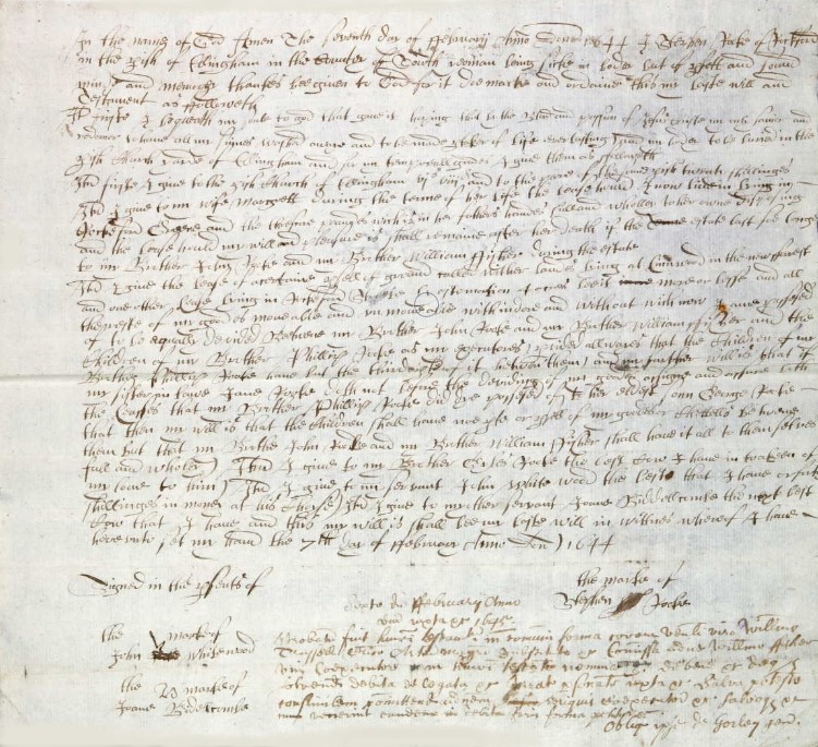
In the name of God Amen
The fourth day of February Anno Domino 1644 I Stephen Rook of Rockford in the Parish of Ellingham in the County of South Yeoman being sike in body but of ??? and sound mind and memory thanks be given to God for it do make and ordain this my last Will and Testament as ????
I??? I bequeath my soul to God that gave it hoping that be the ???? and ??? of Jesus Christ my only Saviour and redeemer to have all my ???? ???? away and to be made ??? of Life Everlasting and my body to be buried in the Parish Church yards of Ellingham and for my Family burial ground I give them as followeth
The first I give to the parish Church of Ellingham ?? ??? and to the poor of the same parish twenty shillings
Item I give to my wife Margrett during the ??? of her Life the ??? house I now live in Lying in Rockford ??? and the ??? ??? ?? with ?? in her father’s ??? full and wholley to her own ??? of my and the ??? ??? my will and ??? it shall remain after her if the ??? last so long
To my Brother John Rook and my Brother William ??? ??? the oftake
??? I give the ??? of ??? of all of ground ??? wither ??? living at ?innwood in the now ??? and ??? other ??? lying in Rockford ??? by estimation 4 acres ??? ??? or ??? and all ??? of my goods of movable and unmovable withindor and without with now I and ??? of to be equally divided Between my Brother John Rook and my Brother William ??? and the Children of my Brother Philip Rook as my ??? provided always that the Childre of my Brother Philip Rook ??? ?? the ??? of it ??? them ? and my ??? Will is that if my Sister in Law Jane Rook doth not before the dividing of my goods ??? and ??? ??? the ??? that my Brother Phillip Rook did ??? ??? of his ??? Son George Rook that ??? my will is that the children shall ??? ??? or ??? of my goods or chattels ??? them but that my Brother John Rook and my Brother William ???? shall have it all to themselves
Item I give to my Brother Charles Rook the ??? ??? I have in ??? of my ?? to him my love to him
Item I give to my servant John White wood the ??? that I have or forty shillings in money at ??? ???
Item I give to my other servant Joan? Biddlecombe the ??? ??? ??? that I have and this my will is ??? ?? my Last Will in wittnes whereof I have hereunto set my hand the 7th day of February Anno Domini 1644
Signed in the ??? of Stephen the \ mark of Rook
John the \ mark of Whitewood
Joan the \ mark of Biddlecombe
Family added to Ancestry Tree.
Brother John Rook
Brother William ????
Children of Brother Philip Rook
Sister in Law Jane Rook
Son of Brother Philip Rook
Brother Charles Rook
Grand children Dantor
Extract from will pertaining to Christopher Biddlecomb of Hightown
I Christopher Biddlecomb of Hightown ...
Item I gift to my Grand children Elinor Dantor, Iornd Dantor, and Margartt Dantor, and Richard Dantor and to {.....} and {......} of them five pounds lawfull money of England.
Possibly 'and to each and either of them'
Birth and Baptism
Marriage
Death and Burial
Grand child Thomas Biddlecomb
Extract from will pertaining to Christopher Biddlecomb of Hightown
I Christopher Biddlecomb of Hightown ...
Item I give to my Grandchild Thomas Biddlecombe five pounds of lawfull money of England.
Birth and Baptism
Marriage
Death and Burial
Grand children Biddlecomb
Extract from will pertaining to Christopher Biddlecomb of Hightown
I Christopher Biddlecomb of Hightown ...
Item I give to my Grandchildren Richard Biddlecomb and Elizabeth Biddlecomb and to {.....} and either of them five pounds lawfull money of England
Birth and Baptism
Marriage
Death and Burial
Christopher Biddlecomb
Christopher Biddlecomb or Christofer Bidelcom
Birth and baptism
A potential match for Christopher's baptism.
First name(s) Christofer
Last name Bidelcom
Gender Male
Birth year -
Birth place -
Baptism year 1571
Baptism date 19 Mar 1571
Place Ringwood
County Hampshire
Country England
Father's first name(s) John
Father's last name Bidelcom
Mother's first name(s) -
Mother's last name -
Record set England Births & Baptisms 1538-1975
Category Birth, Marriage, Death & Parish Records
Subcategory Parish Baptisms
Collections from England, Great Britain
Another potential match for Christopher's baptism.
First name(s) Christofer
Last name Bidelcom
Gender Male
Birth year -
Birth place -
Baptism year 1592
Baptism date 18 Feb 1592
Place Ringwood
County Hampshire
Country England
Father's first name(s) Morris
Father's last name Bidelcom
Mother's first name(s) -
Mother's last name -
Record set England Births & Baptisms 1538-1975
Category Birth, Marriage, Death & Parish Records
Subcategory Parish Baptisms
Collections from England, Great Britain
Marriage
See the tab Christopher Biddlecomb's Wife for thoughts about his marriage.
Death and Burial
Death would have been between writing the will and any codicil and the date of proving the will. If the rule of proving within is applied his death would have been close to the proving date.
| Date of Will | 15 July 1647 |
| Date of Codicil | None |
| Date of Proving | 26 May 1649 |
Looking at the Hampshire Genealogy Society Burial Records;
Parish of Ringwood, 16 March 1647 Christopher Biddlecombe is one that jumps out on first impression, but that is before the Will was signed.
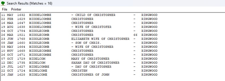
The above was the result of a search for the parish of Ringwood with a first name starting with Chris and a surname starting with Bid, both to deal with the various spelling of the names encountered in records.
There are no appropriate records here.
Widening the field to the whole of Hampshire, surname starting with Bid, and the year 1648 +/- 1, gave the following result. Again, no matching record.
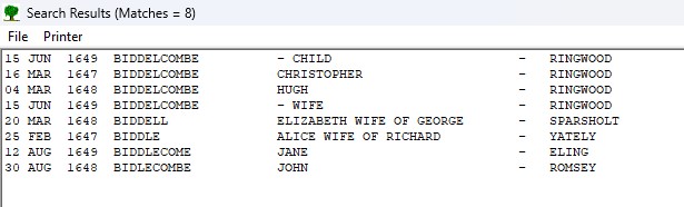
Perhaps a trip to the Hampshire Records Office in Winchester is required.
Christopher Biddlecomb's Parents
Christopher Biddlecomb's Parents
From the potential baptisms found so far, one to John Bidelcom baptism date 19 Mar 1571 and another to Morris Bidelcom with a baptism date of 18 Feb 1592. That calculates the between baptisms duration as being 20 years, 11 months including the end date.
Given a proving date of the Will of 26 May 1649, which I believe had to be completed within three months of death would result in a date of death of about say 26 March 1649.
The date the Will was written was 15 July 1647
Assuming that in both cases he was baptised at a very young age, at least before his first birthday, if his father was John he would have been 78 years of age at his death and 76 when he wrote the will.
If his father was Morris he would have been 57 years of age at his death and 55 when he wrote the will.
If we consider average generation gaps to be twenty years, Christopher could have married at twenty, and his first child married also at twenty, so he would be forty. Accordingly his first grand child could have been when he was 41 years of age. Christopher appears to have 4 grand children in one family from his Will. This would suggest that he was at least 45 years of age when he wrote the will.
Unfortunately, this exercise did not separate between John and Morris.
Trying something else.
From the HGS marriage records;
27 Jan 1592 Ringwood Christopher Bidelcom Elizabeth Rogers
Well a baptism date of Friday 18 Feb 1592, which is after a marriage date of Thursday, 27 January 1592 by 23 days, I think that conclusively rules out Christopher son of Morris as being married to Elizabeth Rogers. Whereas a baptism date of Monday,19 Mar 1571 would give an intervening period to the marriage date of 20 years 10 months. If he was married at full age, it would indicate that Christopher was born before 26 January 1571.
The probability is therefore that John Bidelcom is his father. There is no indication from this as to who his mother was.
Christopher Biddlecomb's Wife
Christopher Biddlecomb's Wife
A potential Wife for Christopher
First name(s) Christofer
Last name Bidelcom
Name note -
Marriage year 1591
Marriage date 27 Jan 1591
Marriage place Ringwood
Spouse's first name(s) Elizabeth
Spouse's last name Rogers
Spouse's age -
County Hampshire
Country England
Record set England Marriages 1538-1973
Category Birth, Marriage, Death & Parish Records
Subcategory Parish Marriages
Collections from England, Great Britain
From other Ancestry trees it is suggested that Elizabeth Rogers may be a widow, with a maiden name of Elizabeth Humber, B:11 May 1575 Ringwood, Hampshire, England. Father Henry Humber and husband Robert Rogers who died 25 Sep 1591 Ringwood, Hampshire, England, however, that date of death is after the marriage at the beginning of 1591.
Another potential later life Wife for Christopher
First name(s) Christopher
Last name Bidelcom
Name note -
Marriage year 1622
Marriage date 24 Oct 1622
Marriage place Ringwood
Spouse's first name(s) Cisley
Spouse's last name Bidelcom
Spouse's age -
County Hampshire
Country England
Record set England Marriages 1538-1973
Category Birth, Marriage, Death & Parish Records
Subcategory Parish Marriages
Collections from England, Great Britain
Christopher Biddlecomb's Children
Christopher Biddlecomb's Children
Christopher Biddlecomb's Summary
Christopher Biddlecomb's Summary
Christopher Biddlecomb was ill when he wrote his Will on 15 July 1647. He appears to have died a couple of years later in 1649 as the Will was Proved 26 May 1649
He is a yeoman of either High Town Farm or of the nearby hamlet of High Town, later known as Hightown. All near Ringwood in the County of Hampshire.
Christopher mentions in his will two sons, John and Richard Biddlecomb and a daughter Margaret whose married name was Rook.
He also mentions three sets of named grandchildren.
Baptism for Margaret Biddlecomb, daughter of Christofer Biddlecomb on 25 Mar 1606.
End of this article in the series, select the next collection or person to view from the list below.
End of Old Template material pertaining to Christopher Biddlecomb. Not relevant.
Sir Richard Mill, 5th Baronet (c. 1689 – 16 May 1760) of Woolbeding House, Sussex was a British landowner and politician who sat in the House of Commons between 1721 and 1747.
Mill died on 16 May 1760. He had four sons Richard, John, Henry, and Charles who succeeded to the baronetcy in turn. His five daughters were Margaret, Philadelphia, Elizabeth, Mary and Martha.
The Mill Baronetcy, of Camois Court in the County of Sussex, was a title in the Baronetage of England. It was created on 31 December 1619 for John Mill, subsequently Member of Parliament for Southampton. The third Baronet was High Sheriff of Hampshire in 1685. The fifth Baronet was member of parliament for Midhurst, Penrhyn and Horsham. The sixth Baronet sat as a Knight of the Shire for Hampshire. The title became extinct on the death of the tenth Baronet in 1835.
The National Archives - Camios Court Manor
The National Archives - Mill family, baronets, of Camois Court
Sussex (Camois Court in Trotton, etc) and Hants (Mottisfont, Eling, Longstock, etc) deeds, family and estate papers, incl papers of the predecessor Sandys family, with misc deeds and papers for other counties.
British History Online - Trotton
Catherine Mill, the eldest daughter of Sir Roger Lewknor and Elizabeth, was succeeded before 1587 by her son Lewknor Mill, and he before 1606 by his son John Mill. John was created a baronet in 1619, and in 1664, with Margaret his wife, he conveyed Trotton manor to Ellis Mewet and William Noyes.
This part was also acquired by Lawrence Alcock, whose son Lawrence settled the manor in 1701 on his marriage with Anne Fuller. Lawrence was buried at Trotton in 1723; none of his sons having left issue, Trotton manor passed to his daughters Jane wife of John Radcliffe, and Anne wife of George Bramston. Anne had no children, and George Bramston mortgaged his share of the manor to Samuel Child in 1745, and sold it in 1757 to John Fraine. In the following year Edward Radcliffe bought this part of the manor, £8,680 being paid to Agatha Child, representing the mortgagee, and £975 to Fraine.
Jane Radcliffe died in 1752 and her son John Radcliffe succeeded to the other part of the manor as devisee and heir at law of Arthur Radcliffe brother of Edward, and in 1779 he sold the whole to Thomas Samuel Jolliffe. Jolliffe exchanged the manor for manors in Somerset with Samuel Twyford in 1786, and it was sold by a later Samuel Twyford to Frank Mowatt. He sold it to Reginald Henry Nevill, of Dangstein, whose widow Lady Dorothy Nevill and their eldest son split up the property, most of which, with apparently any surviving manorial rights, was acquired by Lord Leconfield.
The first paragraph links Trotton Manor to John Mill, and the Baronetcy. The last paragraph of this extract links the name Radcliffe to Somerset and Trotton, and Radcliffe is a name that reappears in this story.
Camois Court is often assumed to be near Barcombe Cross and Barcombe, to the North of Lewes in Sussex.

It is understandable as it clearly states Camois Court and Camois Court Farm, circled in blue, near Barcombe Cross.
British History Online does have a mention for Camois Court in the Parish of Barcombe.
Camois Court, on the west side of the road between Barcombe and Barcombe Cross, has 17th-century stopchamfered beams, a contemporary door, and curious twisted columnar newels, two supporting an arch in the hall and a larger one in the staircase. There are others at the Anchor, and Ewhurst, Spithurst. These all appear to have been ship furniture introduced by Sir William Grantham when he reconditioned these houses about the beginning of this century.
...
Manors
...
The manor of CAMOYS COURT alias BARKHAM CAMOYS, lying partly in Barcombe, but also in Ditchling and Newick, was probably represented about 1198 by land held by Maud de Bercamp. The overlordship descended with the rape. In the division of the barony in 1439 the 1½ knight's fees formerly held by John de Gadesden, in which this land was included, were divided. Half a fee in Ditchling was assigned to Elizabeth, Lady Bergavenny; (fn. 24) one fee in Bevendean and Barcombe went to the Duke of Norfolk. In 1543, however, Camoys Court was held of the joint owners of the barony, and it still owed suit at the court of Lewes down to 1835 at least.
From Maud de Bercamp the holding passed to her son Ralph de Pierpoint; but William de Pierpoint, who held demesne in Barcombe in 1235, had sold his land there by 1242 to John de Gadesden or Gatesden who was then holding 3 knights' fees in 'Bercompe'. John married Hawise Savage, widow of John de Nevill, in about 1246 and died in 1262. Hawise died about 1269. The marriage of John's grand-daughter and heiress Margaret was granted to Robert Waleraund. In or about 1279 Margaret married Sir John de Camoys but deserted him for William Paynel, whom she married after Sir John's death in 1298. Margaret died about January 1311 and her son Ralph de Camoys was holding land in the vill of Barcombe in 1316. On his death in 1336 his lands passed to his son Thomas, who died without issue in 1372 holding the reversion of the manor, after the death of William de Mallynge, jointly with his wife Margaret. She was still holding them in 1386. Sir Thomas de Camoys, his nephew, succeeded him. In 1412 his lands in Barcombe were worth £5 a year and in 1428 were assessed as ¼ knight's fee. He died in 1421, and was succeeded by his grandson Hugh, then aged seven, on whose death in 1426 the Camoys property descended to his sisters, Margaret, wife of Ralph Radmylde, and Eleanor, wife of Roger Lewknor of Trotton. Ralph Radmylde survived Margaret and died in 1443, when her half of the manor passed to their son Robert, then aged 18. Robert was succeeded in 1457 by a son William, a child of 6, but this part of the manor appears soon to have passed to Roger Lewknor, in whose family the whole manor descended. At this date the manor was still known as Barcombe, but later it acquired the name Camoys Court. From Roger it passed to his son Sir Thomas Lewknor of Trotton in 1478, and in 1484 to his grandson Sir Roger, when the male line died out in 1543. The manor then descended for a time in the same way as Warningore, being divided among Roger's three infant daughters—Katherine, who married first John Mill, and secondly, William Morgan; Mabel, wife of Anthony Stapley; and Constance, wife first of Thomas Foster and then of Edward Glemham. By 1587 Katherine's third had descended to Lewknor Mill, her grandson by her first husband. Mabel and her husband had evidently died without issue, for thereafter the manor descended in two portions, one half in the Mill family and the other in the Fosters, descendants of Constance by her first husband. The first half remained with Sir John Mill, bart. (son of Lewknor), and his descendants until 1666, when it was sold to William Lane, whose daughter Elizabeth married John Smith of Hamsey. In 1709 the children of John Smith, William, Ann, and Abigail Smith sold it to Thomas Medley of Conyborough in Barcombe. This portion included the 'piece of arable land whereupon the ancient seat or mansion house called Camois Court formerly stood'. It remained in the Medley family and descended with the main manor of Barcombe until, at least, 1835.
At this point I realise that I have some of these names on my main Family Tree. I have been building a Mill family tree in the background as I explore this dynasty, on my Research Tree. I must now transfer this to my main tree and link it to the people there to establish my very very remote relationship.
I am not expecting to become landed gentry as a result.
The Milne Map of Hampshire 1791

Grove House, also Known as Grove Place, Nutshelling, is associated with Sir Charles Mill. (Circled in blue)

Sir Richard Mill of Grove Place Bart is associated to Property 322
John Mill Esqr., is associated to Property 332
John Mills Esqr., Bentley is associated to Property 333.
Timeline
Compiled history
Conclusion
B
C
D
ArcGIS Story Map
Using the information in the abovementioned spreadsheet, I have also created an ESRI / ArcGIS Story Map which shows the location of the places of abode, indicated by numbers on Taylor's map, on a modern map. Follow the link to go directly to Taylor's Map of Hampshire 1759 and the places associated with the List of Gentlemen or see the slightly squeezed version embedded below.
Sorry, to be a stand alone item, it does repeat some of the above, but has new stuff as well.


 Land of King William
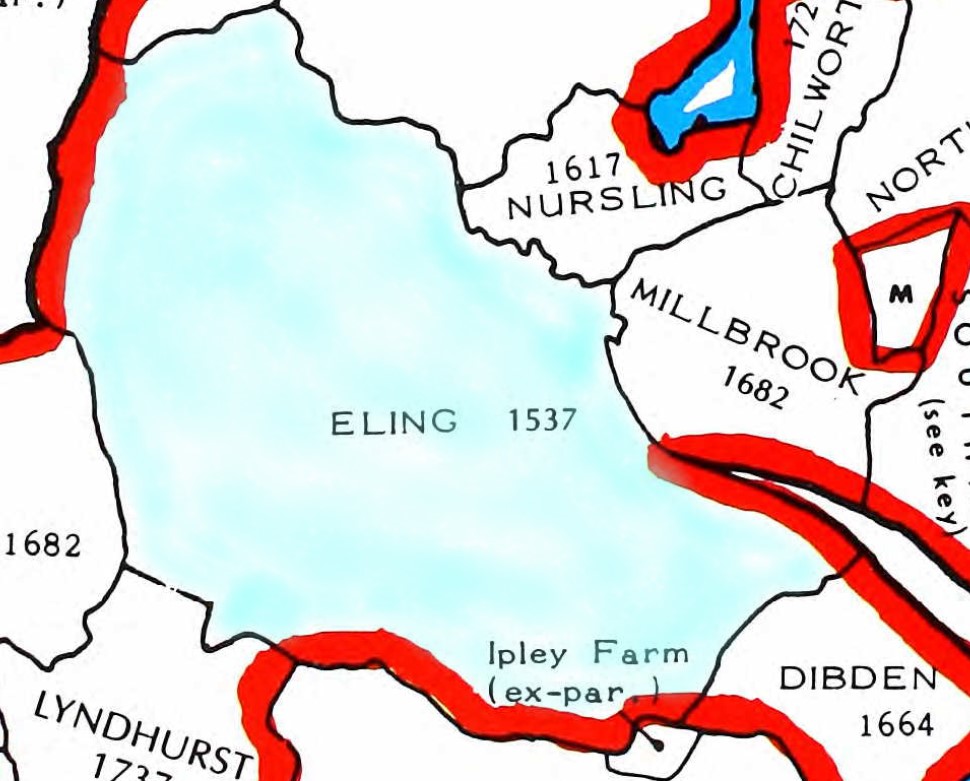
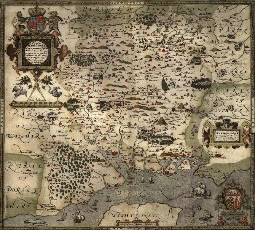
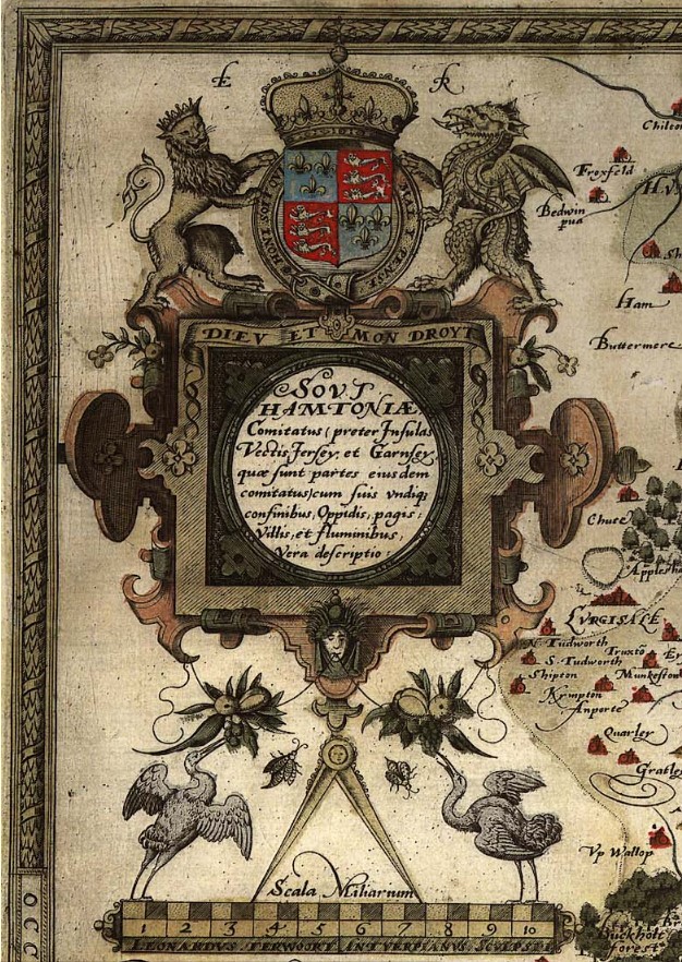
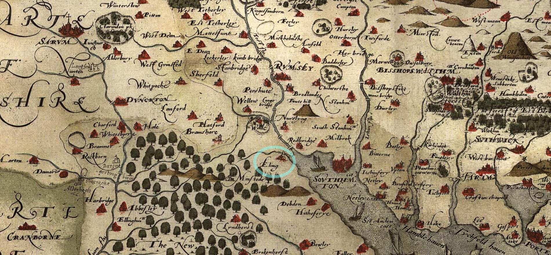
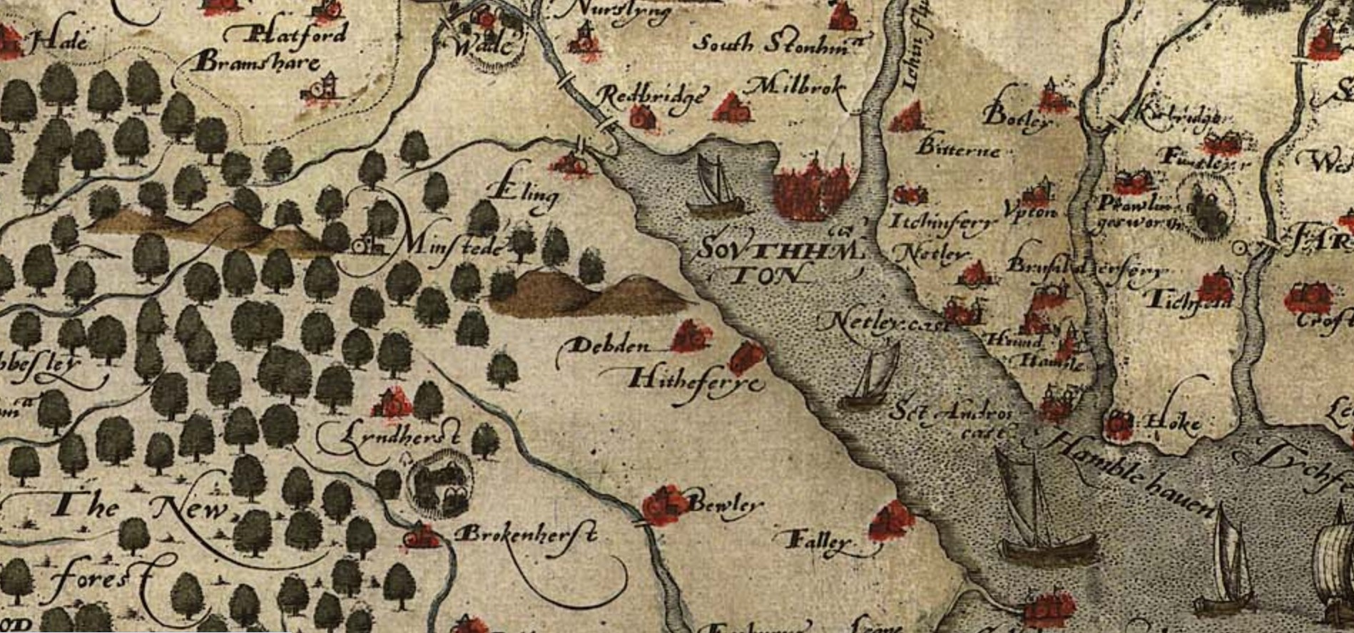
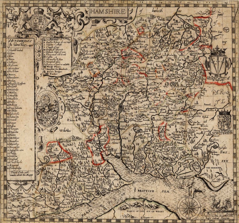
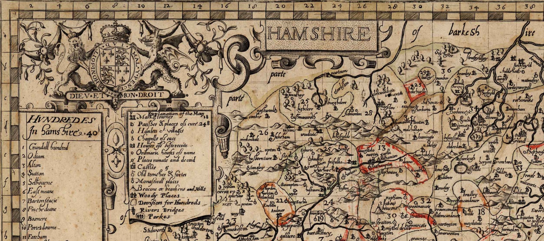
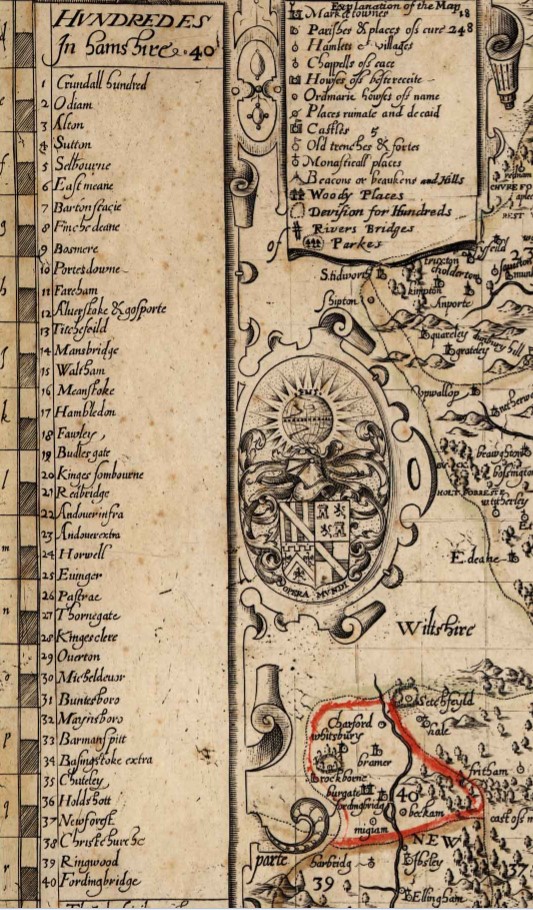 Details