
A Study of the Parish of Millbrook, Hampshire
My Millbrook Parish one place study The beginning was actually just a restart triggered by a post in the Facebook group of Guild of One-Name Studies by Karen Heenan-Davies on 7 August 2018.
'I want to do analysis and maps of the BMD and census records to show how my surname Heenan changed geographically over time'
Well that got me thinking about how I had started plotting the Enumerators route of the 1841 Census of Millbrook. It was very rural then.
Link that to thoughts of GIS and BIM, and I join the conversation.
Later that day I start a new Google Map of Millbrook and using the Census images on Ancestry I start plotting the routes and key named places. I also start a spreadsheet which will expand the data extracted from the Census and also provide the upload to ESRI for the interactive ARCGIS Mapping.
Obviously it is not that easy a task to locate things mentioned on an 1841 Census and plot them on a current Google Map. My process varies but the simple version is;-
- Can the place still be found on current mapping? If so use that data to plot on my map.
- Try to locate the place on a Ordnance Survey map of the period, either paper or those digitised maps held my the National Library of Scotland Mapping. There are other sources of OS maps, but this one is free to use.
- Compare the location of the found place with current maps, there is a slider to change the transparency of the old to new maps on the NLS georeferenced maps, as well as a 'Spy' button.
- Search the internet for additional data, either prime or as corroboration.
- I use Grid Reference Finder to translate any location data into Latitude Longitude and to check the satellite image to ensure correct positioning.
- I create layers on my map to correspond to the Census Enumerator Districts.
- I use the search by inputting the Lat Lon (cut and paste) to find the position and plot the pin onto the map in the appropriate layer.
All of this is just to get an understating of the Census walk or route, to help provide location information to each of the homes recorded on the Census.
But it is not even that easy as some names are not to be found. For instance Turnpikes turned into their own mini study with it's own article on this site.
The map below is the result of adding Turnpike data of the area to a current Google map, and any information found so far.
The map can be enlarged by the icon top right and a menu shows with the icon on the top left. Layers with information on Turnpike roads and tollhouses, as well as individual Census Districts can be turned on or off.
It is commonly accepted that places and maps change over time. This is further complicated by shorelines changing, mudflats becoming docks and canals becoming railway lines or backfilled. District one has all of these problems. An old 1871 OS map shows all of the old positions. Some of these are approximately replicated on the My Maps.
The canal in question is of the Southampton and Salisbury Canal Company and there are photos of the locations together with the plan, old, and current maps. There is also a map of the area in the British Library.
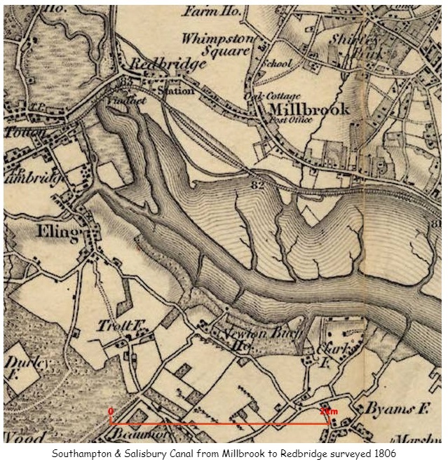
The above map not only shows the canal but also other places around Millbrook including Whimpston Square, which correlates with Wimpston on later maps and a road called Wimpson Square on a 1911 Census record for a family called Street.
The link to the British Library held maps provided invaluable additional information including additional information about names and locations of Turnpike gates to confirm or correct data sourced elsewhere.
A named boundary of the 1841 Census is Cockerwood Land, in District 6 for instance. However, I have not found that road on any current map. There is some reference to Hill Lane on a paper about Taunton's College and a Cockroads Farm shown on some of the old OS Six inch maps.
'A map of Southampton in 1800, by Doswell shows a building next to Hill Lane and known as Cockerwood House. The first OS map of Hampshire shows an unnamed building within a rectangular enclosure. The details are very similar to those shown on the 1826 map of Hampshire. The enclosure map of Hill and Shirley in 1830 shows two main building complexes, both aligned north–south, one adjacent to Hill Lane and the other, to the north-west of it, set slightly back from Hill Lane. This second building interrupts a rectangular enclosure that otherwise surrounds the building on Hill Lane.'
OS 1866 Map Link There is also a short article on Sotonopedia There is also relevant information on OS First Series Map showing Whithedswood Common. Even more interesting is the British Library held map. This map appears to predate the OS First Series and includes Shirley Common, Warren, Shirley, Hill, Whiterswood Common, Cock Road, Shirley House, as well as Millbrook and Redbridge. Whilst the map does have the words Shirley House it is not clear exactly where it is. Possibly somewhere close to Foundry Road. Later maps pin point Shirley House, which in turn suggests that what appears to be Shirley Brick, on the 1806 map above is in fact Shirley Park.
Unsurprisingly, research into one area takes you to another. The Parish of Millbrook on British History Online leads to manors of Millbrook, which again leads to the Manor of Shirley, and latterly Shirley and Hill. This article provides some of the names of the Lords of the Manor in the 13th and 14th Centuries. I will add these names to my One Place Ancestry Tree, The people of Millbrook. Sometimes the entries produce hints and additional information about the person and their family. The most successful of these so far was the Whitehead family who held the the Manor of Shirley and Hill from 1433 until Mary, the daughter of Henry and Mary, married Alexander Thistlethwayte in 1717, and the manor thus passed to the Thistlethwaytes with whom it remained for a further considerable period. Whilst they were holders of the Manor of Shirley and Hill, their main seat appears to have been in Norman Court, West West Tytherley, Hampshire, on the border with Wiltshire. Indeed, Norman Court Park is shown on the OS Map as being the boundary between Hampshire and Wiltshire. Norman Court Park is about 20 miles away from Shirley, so I am unsure if they ever lived in Shirley House. Further investigation quickly reveals that Shirley House was built in the later part of the 18th century for retired West Indian plantation owner, Richard Wilson. It stood at the junction of modern-day Clarendon and Henty Roads. The site is bisected by modern Shirley Park Road, which was named after the estate. Sales particulars of 1792 show it to be a substantial dwelling, with double coach houses, stabling for eight horses, pleasure gardens, a small farm and a large paddock, the total comprising about 48 acres. In 1802 it was occupied by the Reverend Sir Charles Rich and it remained with that family until 1836, when it was sold to property developer William Henry Roe. Roe eventually sold off the estate for development and the house was demolished in the 1880s. More names to add to the Ancestry Tree.
Information on Manors can also be found at the National Archives. The search for Millbrook manor reveals 34 collections held in 4 archives with a date range of 1189 to 1925. Some of these also refer to Nursling Manor, perhaps as the main manor of the two, with some records held at Winchester. Hampshire County Council in the form of the Hampshire Records Office also has a significant number of records, including for instance;-
Plan of Hill and Shirley manor (Whitheds Wood), Millbrook, property of Robert Thistlethwayte, 1778; plan of Hill and Shirley enclosure, 1830; mortgage of tenement on south side of Winchester, John Osman to Elizabeth Merriweather, 1694.
If Nursling Manor and Millbrook Manor are so linked in court records, should I expand my One Place to be Nursling and Millbrook?
Whilst some of the previous holders of the Manor of Shirley have also been Mayor of the adjacent town, the list of Mayors of Southampton does not include a Whitehead.
The Ancestry tree now includes many generations of Whitehead due to this. Also, I have created an article about Shirley on this site.
Off I go on another side road. From Shirley House or Park, the trail leads me to THE COUNTRY HOUSES OF SOUTHAMPTON By JESSICA VALE. Another paper by the Hampshire Field Club and Archaeological Society. However, perhaps this is not quite so much of a diversion. Some of the early Census Enumerators record the route taken by reference to the large houses of the time, whilst others just record something like 'Shirley Common' for almost the whole of the census. The latter not entirely helpful in establishing locations of dwellings. Even so, sometimes historical papers of old houses reveal the names of the occupants which can be correlated to the census.
The occupancy of Shirley House by the Rich family led me to another long line in Ancestry, then confirmed by other sources.
The Rich Baronetcy, of Shirley House in the County of Southampton, was created in the Baronetage of Great Britain on 28 July 1791 for Reverend Charles Rich. He was the son-in-law of the fifth Baronet of the 1676, and had inherited the estates and assumed the name and arms of Rich. This creation became dormant upon the death of the sixth Baronet in 1983, but heirs are still thought to be living. From Rich baronets.
Another source was the Dictionary of National Biography, Volumes 1-22.
The Rich Baronetcy, of London, was created in the Baronetage of England on 24 January 1676 for Charles Rich, of Mulberton, Norfolk, with remainder to his son-in-law and distant cousin Robert Rich, son of Nathaniel Rich, who inherited the baronetcy the following year. He was a successful politician. His younger son, the fourth Baronet, was a distinguished cavalry officer. The title became extinct on the death of the sixth Baronet in 1799.
Looking into a Nathaniel Rich 1585-1701 takes us into the English Civil War and the formation of the New Model Army. Nathaniel became Colonel of a regiment of horse upon the formation of the New Model Army and was therefore among the first of our professional Army. He fought on Cromwell's side against the King.
I wonder, is the fact that the formation of the current professional army traces back to the Parliamentarians, the reason why it is not a Royal Army, it the way that Royal Navy and Royal Air Force are.
I have just found a possible source of tithe maps of the parishes of Hampshire. This has the potential to significantly aid the correlation of places and families in the 1841 census.
Two interesting metrics I am trying to include into my spreadsheet are voting and adulthood status which requires date thresholds. An interesting summary of the English path to democracy is on the National Archives site.
In my meanderings around the Fifield family and the Standbridge Estate, I found the name Humby, and I have a later relative William Edward Humby 1831-1906; father-in-law of 2nd great-aunt who lived in 1 Rose Hill Cottages, Romsey Road, Old Shirley, Millbrook, Hampshire, England. I have found him in the 1871 Census which I have plotted the Enumerators route and William's home on the map below.
One of the interesting and challenging aspects of plotting locations found in Census returns is the passage of time has eradicated a large number of the buildings and places mentioned. Therefore they cannot be directly plotted onto a current map. Even some current roads were previously known by another name. Reference to old maps helps to resolve some of the locations. It is a slow process, but a worthwhile investment in time and effort. The map below is a collection of places found and plotted. It is still growing, and becomes the basis of Census Enumeration route plots, which in turn will feed data into an ESRI data map.
Another interesting, albeit sometimes unlikely, source of information, is Facebook. There is a group called Freemantle Local History Group. It is fascinating. It is a private group so although I have included links to information sources they may not open for you.
Cedar Lodge House, off Oakley Road, was built in the mid nineteenth century. It was originally called Mussoorie Villa (after a place in northern India). Nearby 2.68 acre Cedar Lodge Park named after the house opened in 1967. Oakley Road was originally called Mousehole lane, renamed Oakley Road in 1909 in honour of the then Mayor, Richard Garrett Oakley.
Another link in the group led me to a collection of Old Maps of Hampshire.
Milne's Hampshire 1791 section 43
The map shows how rural the whole area was in 1791, with the majority either estates or a huge area of common land. The estates appear to have the names of the owners associated with them. J Jarrett Esq was annotated above Freemantle Park. The size of Nutshalling Common, Shirley Common, and Whiteheads Wood is amazing. So much land in Common usage. Just a few years later the impact of the agricultural and industrial revolutions were clear to see. On the one hand, it is a major land grab by the establishment and the wealthy, but on another it is increasing the productivity of the underutilised and uncared for land, to feed an expanding population. Name changes are also an important consideration. Nutshalling has previously been Nhutscelle, Hnutscilling, Nutshullyng and is now known as Nursling. Whiteheads Wood on this map becomes variously Whitheds Wood, Whithed Wood on later maps. Whithedswood Road becomes Shirley Avenue. Wynsor is shown on this map as Wineston and is now Wimpson. Old roads such as Romsey Road are clearly shown and are still evident whilst Millbrook Road, whilst on a similar alignment but considerable developed. Turnpikes have also come and gone. Shirley is recorded as a manor with a mill in the Domesday Book; the mill standing to the west of the present Romsey Road/Winchester Road junction, at the confluence of the Hollybrook and Tanner's Brook streams. Shirley Mill had three large ponds, to the north of Winchester Road. One of the three mill ponds remains today, accessed by following the Lordswood Greenway. The mill can be seen adjacent to Shirley House and both Hollybrook and Tanner's Brook streams can be seen meandering towards the mill through Nutshalling and Shirley Commons.
Another Map, Taylor's Hampshire 1759 section 43
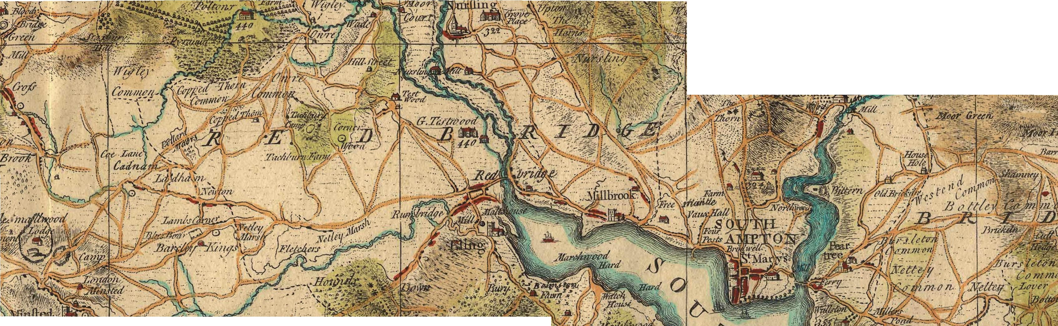
Millbrook is clearly shown on this map, with Freemantle, Vaux Hall, and Four Posts between it and Southampton. Mouse over the image to zoom in to Millbrook. Grove Place and Nursling is at the top the map. Shirley, despite being mentioned in the Domesday Book is not identified on this map.
Shirley was a settlement in Domesday Book, in the hundred of Mansbridge and the county of Hampshire.
It had a recorded population of 12 households in 1086.
Land of Ralph of Mortimer
Households
Households: 4 villagers. 3 smallholders. 5 slaves.
Land and resources
Ploughland: 8 ploughlands. 2 men's plough teams.
Other resources: Meadow 12 acres. Woodland 6 swine render. 1 mill, value 2 shillings and 5 pence. 1 fishery. 1 church.
Valuation
Annual value to lord: 5 pounds in 1086; 5 pounds when acquired by the 1086 owner; 5 pounds in 1066.
Owners
Tenant-in-chief in 1086: Ralph of Mortimer.
Lord in 1086: Ralph of Mortimer.
Overlord in 1066: King Edward.
Lord in 1066: Cypping (of Worthy).
The Domesday Book records a church being present at Shirley in 1085, but on 1 May 1574 the parish of Shirley was amalgamated with that of Millbrook as the small Shirley congregation could not afford the upkeep of the Shirley church building. The Shirley church was demolished in 1609, with stones from the old building used to enlarge St Nicholas' Church building in Millbrook.
By 1836, the population of the combined parish had reached 2,375 inhabitants, and the old Millbrook parish church was too small. Land was donated for a new church building in Shirley by Nathaniel Newman Jefferys, and Church Building Society combined with private funding to pay for the structure itself. The new church, dedicated to St. James, was designed by local architect William Hinves and consecrated on 20 August 1836 by the Bishop of Winchester with a large crowd present despite "unfavourable weather", according to the Hampshire Advertiser newspaper.
Some extracts from a paper presented to Hants Field Club entitled FIELD SYSTEMS AND ENCLOSURES IN HAMPSHIRE
Hampshire was among the counties reported upon by Wolsey's Commission in 1517.
... 37 Hundreds and eight liberties at which the County (including the Isle of Wight) was divided. The Hundreds for which enclosures are recorded are :
Basingstoke, Crondall, Kingsclere, Mansbridge, Odiham, Redbridge, Shutterley (i.e. • Chuteley) and Somborne, and the places. mentioned are : Al( d)ington recte Aldington, Bewraper (Beaurepaire), Bramsyll " Breche and Sockborowe " (field names only ?),. Dogmersfelde (Dogmersfield), Erleston (Earlston), Ewurst. (Ewehurst), Farley . (Fafleigh Chamberlayne),- Ichill, " Loke Dewer," " Newtosberye," Wynsor (in Millbrook Parish ?), and the total area is some 562 acres.
Hampshire is not included among the 14 counties covered by the Depopulation Act of 1536, though curiously enough the Isle of Wight is.
The County Agricultural Survey was written by the. Drivers, who describe themselves as " of Kent Road, Surrey." They are sorry to observe in the County such immense tracts of open heath and uncultivated land, which tend to remind the travellers of voyages among the barbarians ; they point out, however, that in this respect Hampshire is no worse than Wiltshire and Dorset, perhaps a trifle better. This is no excuse for it. Near Southampton is a great deal of open land which if enclosed and cultivated will give good crops of corn. There are large downs towards Fareham and Warnford,85 and much open land with some good down near Petersfield. As to the forests and wastes, the Drivers are astonished that the Crown Lands in particular should have remained so long in a state of neglect. If properly managed they would pay much of the interest on the National Debt. A general Act should be passed at once, preferably entrusting enclosure to the Commissioners of Crown Lands:
As to other open land, it might well not be worth enclosure for tillage, and still be worth taking in for planting. No " gentleman can sit down easy, and say he has discharged his duty to his family when he is conscious he has neglected to pursue those measures, which, in a few years, would increase his property so amazingly." . Commonable land of every kind can be regarded as little better than waste, since everyone exhausts it, and no one pays the least • attention to. its support and improvement. "All this would be easily remedied by a general inclosure bill, which would reduce the expense. of inclosures, and would be a spur to that improvement." Wool production would certainly not decrease on enclosure, every farmer in his own interest keeps as many sheep as he is able, and he can feed twice as many on land in severalty as on the corresponding area in common.
Note the reference to Depopulation and read more about it here. By 1530 the population of England and Wales had risen to around 3 million. At the end of the 17th century it was estimated the population of England and Wales was about 5 1/2 million. The population of Scotland was about 1 million. The population of London was about 600,000. London went on to become the biggest city in the world for a while. In the 19th century Britain became the world's first industrial society. It also became the first urban society. By 1851 more than half the population lived in towns. As our population approaches 70m it is interesting to think of depopulation efforts at 3 million! The maps of Millbrook clearly show the urbanisation of the countryside.
Following the Tithe Commutation Act 1836 Tithe Maps were produced which recorded both the Landowner and Occupier for most lands. From the Tithe Apportionments records it is apparent that on 4th March 1843 Lady Hewitt
was both the Landowner and Occupier of Plot 875, Freemantle Estate, described as House Offices and Pleasure Grounds, with an area in statute measure 6,0,2, about 2.4 Hectares.
Nathaniel Newman Jefferys was both Landowner and Occupier of Plot 825 described as House Offices and Garden, an area of 2,2,24 imperial, on 4th March 1843. However, one plot does not show the full picture.
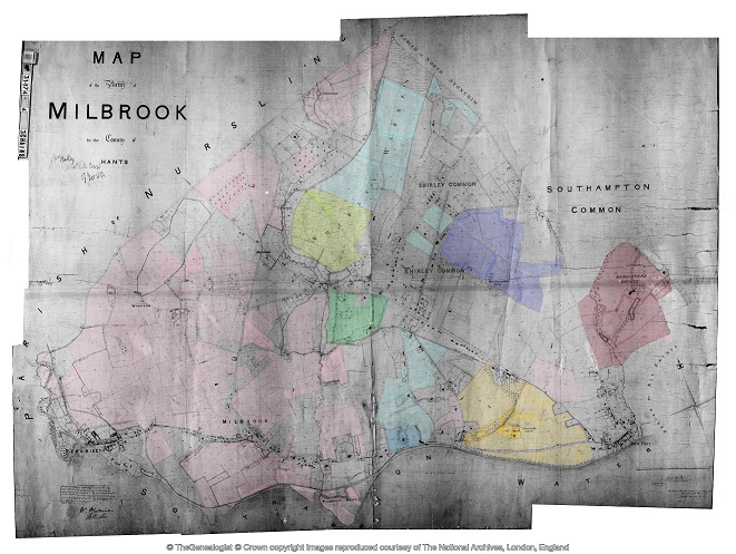
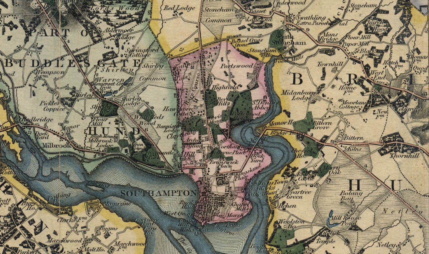
Using the Tithe Apportionment map of the Parish of Millbrook, Hampshire, as a base, I have colour washed some of the plot landowners. The Freemantle and Banister Estates, pale orange and brown respectively can be clearly seen. The landowners in 1843 where Lady Hewitt and Reverend William Fitzhugh. Shirley Park, owned by William Henry Roe, is in green. Blightmont Lodge, occupied by Lady Lisle, just north of Millbrook Road, and part of the larger Berrywood estate owned by Nathaniel Newman Jefferys is shown in a slightly darker blue than the light blue of the rest of the estate. It appears that Nathaniel Newman Jefferys has bought a large swath of the newly released Shirley Common land in the area of Shirley Warren. Clement Hoare & William Dunn seem to have also taken advantage of the inclosue of Shirley and Nutshalling Commons, as joint owners of plots coloured lime green. Roads such as Warren Avenue, Warren Crescent and Tremona Road have already been laid out for the impending urbanisation. However, the biggest landholding in the Parish, by a long way, is Sir John Barker Mill and various associates who together are landowners of the pink coloured plots, mainly farmland in 1843, but destined to be developed and absorbed as suburbs of Southampton.
Greenwood's Hampshire 1826 section 53
Moving into the current, the Church of England has a database of interesting statistics about all the Parishes in the country. Below is the Map which covers the original Millbrook Parish and shows the current Parishes of;
Millbrook: Holy Trinity
Freemantle: Christ Church (1851)
Shirley: St James (1836)
Maybush.
Click on the parish to bring up the statistics.
The Parish of Millbrook Tithe Map 1843 including Shirley, Freemantle and Four Posts, layered onto Google Earth Pro and Geolocated. Same base map as the coloured ownership map. Over 20 separate tiles or files to fit spherical base globe of Google Earth. All adjusted to best fit the projection, and align roads and as many details as possible. Below is just an image of the result. Google Earth Pro is desktop based so does not lend itself to sharing. However, using transparency of the layers I can locate buildings on the tithe map and see what is there now. I can also use the Lat and Lon and show on Google Maps to georeferenced individual buildings or plots.
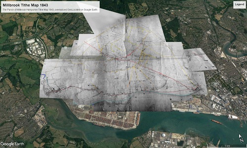
The interactive version is created using a Project in Google Earth and can be seen here, The Parish of Millbrook Tithe Apportionment. Using the Tithe Map plotted on Google Earth Pro above and other maps, I have placed some of the Property names onto a Google Earth Project with an up to date backdrop. History mapped to now.
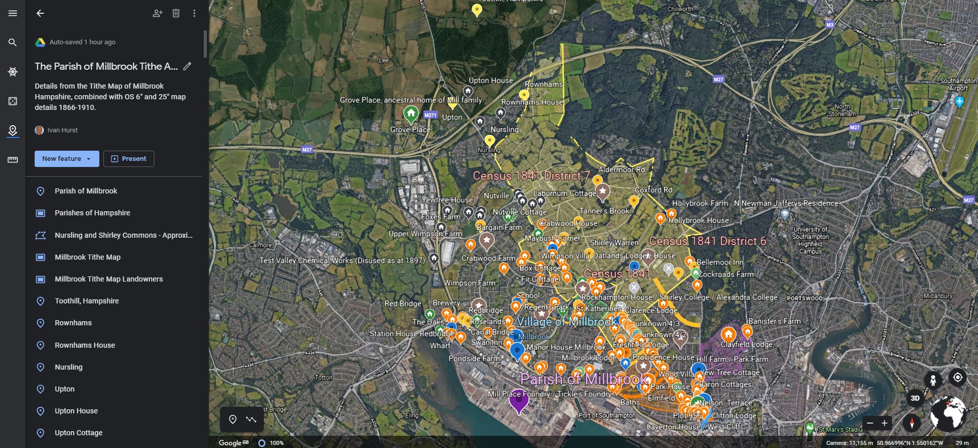
A screenshot as at March 2020. Work ongoing.
Freemantle
Freemantle Estate
more later