Teddington
(For Supporting Data, follow this link)
Zoom out fully to show the extent of Charles Booth's London at the areas of wealth and deprivation become clearly apparent. However, The City of London was not included in the street level survey because it did not house any significant number of residents. For this reason, the City of London remains uncoloured and unclassified on the maps.
Also, look at the bottom left corner of the map, beside the bottom of the Legend and you can find Teddington. See how far outside Booth's London Maps it is even though it is now considered part of Greater London.
 The Maps Descriptive of London Poverty are perhaps the most distinctive product of Charles Booth's Inquiry into Life and Labour in London (1886-1903). An early example of social cartography, each street is coloured to indicate the income and social class of its inhabitants.
Compare this to the Church of England Map of Parishes.

Definitely not uniformly wealthy.
Clicking on the above map will allow you to find Teddington, and that it's Deprivation rank (1=most deprived, 12,382=least deprived) is 12,075. I.e. Wealthy. Not necessarily so in 1890, but very much so in 2021.
The family moved to Teddington, Middlesex.
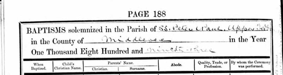
Charles and Charlotte Pomeroy's new church following their move to Teddington was in the Parish of Saint Peter & Saint Paul, Upper Teddington. The church was created in the year 1880, relatively new in 1893 when their first child born in Teddington arrived, adding to the three surviving children that moved form Clerkenwell/Islington somewhen between 3rd May 1891 and 26th January 1893.

The family had moved to 6 Beaconsfield Villas, Fulwell Road, their abode on the Baptism record and the probable place of birth for Emily Ellen Gertrude Pomeroy on 26th January 1893. Baptised on 3rd March 1893. Charles Pomeroy, was still a policeman and by reference to his police retirement record, still with the Metropolitan Police. This is the address he retired to and started to draw his pension from.

The map shows the location of Saint Peter and Saint Paul's Church on Broad Street in Teddington. The maps are now contemporary with our story. This Map is Ordnance Survey 25 inch Surrey XVIII.11, Revised: 1894, Published: 1895.
An extract about Teddington and its expansion from British History Online
In 1861, although the parish contained over twice as many houses as in 1801, Teddington still remained little more than a village. (fn. 40) Among the houses built between these dates was Teddington Hall, which was said in 1891 to have stained glass and bricks from the old Star Chamber at Westminster. It stands on the south of Hampton Road and now belongs to the National Physical Laboratory, but does not apparently contain any old stained glass. Gomer House was built about 1858 by the novelist R. D. Blackmore. By this time the railway had reached Twickenham and Kingston and there were omnibuses to London. (fn. 43) The slight middle-class development which resulted was soon swamped by the building which followed the opening of the two railway lines through Teddington itself. The branch of the London & South-Western Railway from Twickenham to Kingston, on which Teddington Station stands, was opened in 1863, and the Thames Valley Railway, with a station at Fulwell, in 1864. Both lines are now part of the Southern Region. A few years before the railway opened the large estate of the lord of the manor had come into the market, and by 1871 the parish contained 1,034 houses, in contrast to 254 ten years earlier. West of the station appeared what was called Upper Teddington, with small terraced houses stretching between Stanley Road and Waldegrave Road, and the new cemetery (opened 1878) in the north. Broad Street became a new shopping centre with 'shops of a more showy description than those of the mother village', the new Clarence Hotel was built in 1863, St. Peter's Church in 1865-73, the old cottage hospital in Elfin Grove in 1875, and the Town Hall at the corner of the Causeway and Middle Lane in 1886. This last was privately owned and had a ballroom and a theatre as well as the local board of health offices. It was burned down in 1903. North of the High Street, where Manor Road had been laid out in 1861, houses appeared quickly but were more widely spaced, and except for the area just east of the station there was little building south of the High Street. Towards the river, St. Alban's confronted the old parish church in 1889 and by the end of the century villas stretched more or less continuously along the riverside. South of Fulwell Station terraces and semidetached houses appeared, adjoining the slightly earlier settlement of New Hampton outside the parish. In the south near Hampton Wick there were no buildings at all before the gas-works in Sandy Lane were opened in 1851. After 1864 a settlement grew so quickly nearby that by 1868 it had been given the name of New Found Out: it later became called South Teddington. An Anglican school-church was provided in 1867 and a Roman Catholic one in 1884. By the end of the century the district was covered with houses south of Bushy Park Road, with scattered ones reaching north along the Kingston Road. Normansfield private asylum for the feebleminded (now under the National Health Service) in the Kingston Road was opened in 1868 and had well over a hundred patients by 1881. In 1957 it had about 200.
The pace of building rather slowed down in the seventies, later increasing again so that about a thousand new houses were built in each decade from 1891 to 1911. In 1886 a private omnibus service to Hampton Court was started, which was taken over by the London Suburban Omnibus Company in 1895. In 1903 the London United Tramways began a service along Wellington Road and another along Stanley Road, Broad Street, the High Street, and the Kingston Road. By 1936 the trams had been superseded by trolleybuses and the tram-depot north of Fulwell Station is now used as a trolleybus garage. There were also motor buses by 1914. The tram service was said in 1910 to have reduced the attraction of the larger villas which had been built forty years or so earlier, but it accelerated building around the Kingston Road, where there had been comparatively little before, and by the First World War most of the present streets were in existence, and the remaining open spaces were being given over to other uses. The whole area west of Wellington Road, with the exception of the small north-west corner across Staines Road, became the Fulwell Golf Course in 1904, and between the two wars sports grounds were opened on the former Udney farm land. These are now St. Mary's Hospital Medical School Athletic Ground (c. 14 a.) and the Harlequins Sports Ground (c. 9 a.). The Lensbury Club in Broom Road, belonging to the Royal Dutch Shell Group, was built in 1938 and has large grounds on both sides of Broom Road. The local authority also opened several much smaller recreation grounds, and, in 1931, a swimming-bath in Vicarage Road. The National Physical Laboratory at Bushy House has also gradually extended its buildings farther into Teddington since it was established in 1902. By 1957 its grounds reached up to the Hampton Road, Coleshill Road, and Queens Road. Most of the houses built more recently in Teddington have filled gaps between existing streets and buildings: one of the chief characteristics of the district is the mixture almost everywhere of buildings of various dates and types, from the yellow brick cottages of the early 19th century onward. Parts of the High Street and Broad Street have received a facing of 20th-century shop fronts, and the Savoy Cinema, built in the later 1930's, replaced a smaller cinema on the same site. A series of fêtes, commemorated by magazines in which memories of Teddington in the past are recorded, heralded the building of the War Memorial Hospital. The first part of the building was opened in 1929 and the old hospital in Elfin Grove was closed and pulled down. Among the chief areas of building since the First World War were the council estates of 124 houses at Udney Park, 78 houses at Mays estate, and 72 houses at Shacklegate Lane (built respectively in 1921, 1920-1, 1930), and the private estates on the site of Teddington Grove (1929-30), and in the extreme north-west of the parish round Rivermeads Avenue (c. 1933-4). Between 1937 and 1957 Twickenham Borough Council built about 40 houses and flats.
Fulwell Hall Gospel Temperance Mission, Fulwell Road, Teddington, was opened in 1902 after eighteen years of gospel mission work had been done in Fulwell Road. A resident minister was appointed in 1957.

Most of the properties along Fulwell Road are the original Victorian buildings of the first half of 1880. Perry Cottage 1884, Fulwell Terrace 1880, Garfield Terrace 1881 and Woburn Terrace 1881 still have their masonry builders plaques or datestones in place and visible from Google Streetview. Unfortunately the street has been renumbered, so it is difficult to locate 6 Beaconsfield Villas. Using the 1891 census, which used the original names, I have been able to record a probable sequence of the various name, provided the Enumerator walked up one side and down the other, starting at the Stanley Road end. Samuel Dodsworth, his wife and two children lived at 6 Beaconsfield Villas in 1891, before Charles Pomeroy and his family moved there.
 The photo is of Woburn Terrace in Fulwell Road
These are representative of the Victorian Terraces in Fulwell Road and the general area. It is a mixed street with some larger properties including some semi-detached and seemingly one detached property.

The Woburn Terrace 1881 datestone.
Under the new street numbering, the datestone is between number 60 and 58.
1 Woburn Terrace maybe 62 Fulwell Road. The Terrace is numbered 1-7, so potentially 62 to 50. The next property, number 48 maybe 6 Beaconsfield Villas, latter known as 6 Beaconsfield Terrace, the home of Charles Pomeroy and his family.
Continuing to track down a link between the old numbering and the new. Frederick J Ladbrook, a plumber aged 32 lived at 6 Woburn Terrace in the 1901 Census. Frederick Ladbrook, a plumber aged 42 lived at 52 Fulwell Road, from Essex, according to the 1911 Census. That is in line with the predicted match. The rest of the family, his wife Charlotte and son Frederick J Ladbrook also matched with the addition of a new arrival, Elsie May, a daughter aged 8.
William G Coalter at 5 Woburn Terrace was also a match with 54 Fulwell Road. The Hake family lived at 50 Fulwell Road in the 1911 Census. The Curtis family lived at number 48 Fulwell Road, the potential previous 6 Beaconsfield Terrace. They are a young family who wold not have been there 10 years earlier.
Similarly, Frank J Hearn, a 28 year old bricklayer from Yorkshire was in 1 Beaconsfield Terrace in 1901, with wife Ellen, aged 25 and daughters, Ellen B, aged 5 and Gladys aged 3. Francis James Hearn, 37, a bricklayer from Yorkshire, with wife Ellen, aged 34 and daughters, Ellen B, crossed through as not present, and Gladys aged 13, together with 5 new arrivals. All at 42 Fulwell Road. 6 48 5 46 4 44 3 42 2 40 1 38.
In 1901 a different Frederick Hearn, 37, Master Carpenter, from Buckinghamshire lived at 3 Beaconsfield Terrace, with a different family, but with the same surname. Did they do a house swap? Were they renting rather than owning. This did not add clarity.
All still circumstantial, but probably a reasonable conclusion.
 Google Streetview 48 Fulwell Road, possibly previously 6 Beaconsfield Villas/Terrace
The history of land registration in the UK traces its roots in the UK with the Romans who introduced a form of land registration to England and Wales. Regular censuses were held, similar to the one mentioned in St Luke’s gospel, where the ownership and productivity of land was recorded. This formed the basis of a land tax called tributum soli. Interestingly, originally in English law, the only method to transfer freehold property from the seller to the purchaser was through handing over a piece of turf in the presence of witnesses. However, this method fell out after the Statute of Uses was implemented in 1535 which allowed conveyance by deed. The Statute of Uses made it compulsory to enrol deeds in the rolls of the county or in one of the courts at Westminster.
Her Majesty's Land Registry is a non-ministerial department of the Government of the United Kingdom, created in 1862 to register the ownership of land and property in England and Wales.
HM Land Registry registers the ownership of property. It is one of the largest property databases in Europe.
HM Land Registry guarantees title to registered estates and interests in land. It records the ownership rights of freehold properties, and leasehold properties where the lease has been granted for a term exceeding seven years.
HM Land Registry safeguards land and property ownership worth in excess of £4 trillion, including around £1 trillion of mortgages. The Land Register contains more than 25 million titles showing evidence of ownership for more than 85% of the land mass of England and Wales.
Perhaps, the Land Registry has the deeds to 48 Fulwell Road. Is it worth the £3 fee to look online?
An Extract from the Land Registry;
This register contains any charges and other matters
that affect the land.
1 A Conveyance dated 18 October 1881 made between (1) Alfred William Yates (Vendor) (2) Charles Ford and (3) John Hearn (Purchaser) contains restrictive covenants.
NOTE: Copy covenants filed.
2 The parts of the passageway included in the title are subject to rights of way on foot only.
A little extra information, but not the deeds which may well have information about Charles Pomeroy's tenure, if he bought the property rather than rent it.
The Hearn surname appears again. A bricklayer, a master carpenter and an owner, or perhaps builder/developer. The purchase was after the 1881 Census, so I am not expecting information from there.
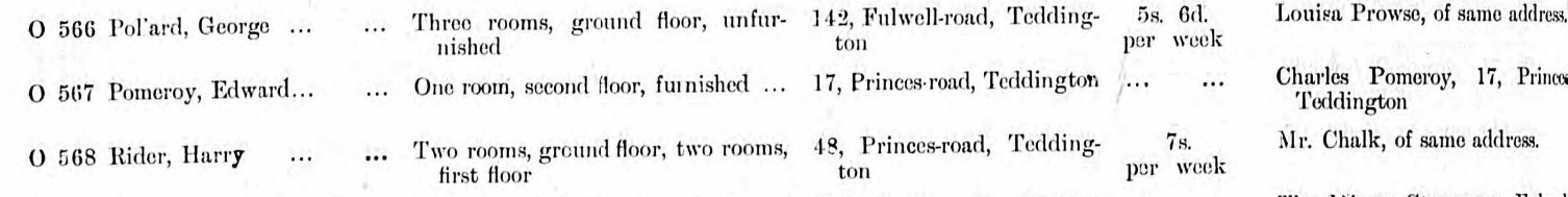
 There are about nine active or retired Policemen living in Fulwell Road according to the 1901 Census. That seems quite a high density. One of those lived next door to Charles Pomeroy, Edmund Dawson a retired Police Constable. Perhaps the high density had something to do with the Metropolitan and City Police Orphanage, not far to the north, on the other side of the railway lines.
Alternatively, could this probate record be the same Alfred William Yates who was the Vendor in the sale of 48 Fulwell Road on 18th October 1818, and could the person granted Administration, which was Alfred William Yates police constable, maybe his son, have anything to do with the number of Policemen living in the road
Enough conjecture, back to facts.
A short recap, or 'Previously on ...' in TV terms.
Charles Pomeroy moved to Teddington from the Clerkenwell area of London between the baptism of Albert Pomeroy, on 3rd May 1891, which took place at St Mary's Church, Islington, and the birth of Emily Ellen Gertrude Pomeroy on 26th January 1893. Baptised on 3rd March 1893.
The birth of Emily Ellen Gertrude Pomeroy adding to the three surviving children that moved form Clerkenwell/Islington with their mother, his wife, Charlotte Elizabeth Pomeroy.
In the 1891 Census taken on the 5th April, Charles and Charlotte Pomeroy were living in 18 Palmerston Buildings, City Gardens Row, in the parish of St Matthews, civil parish of St Luke, Islington, Middlesex, now London. He was a Police Constable aged 36. Charlotte was aged 34
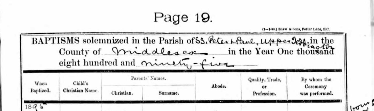
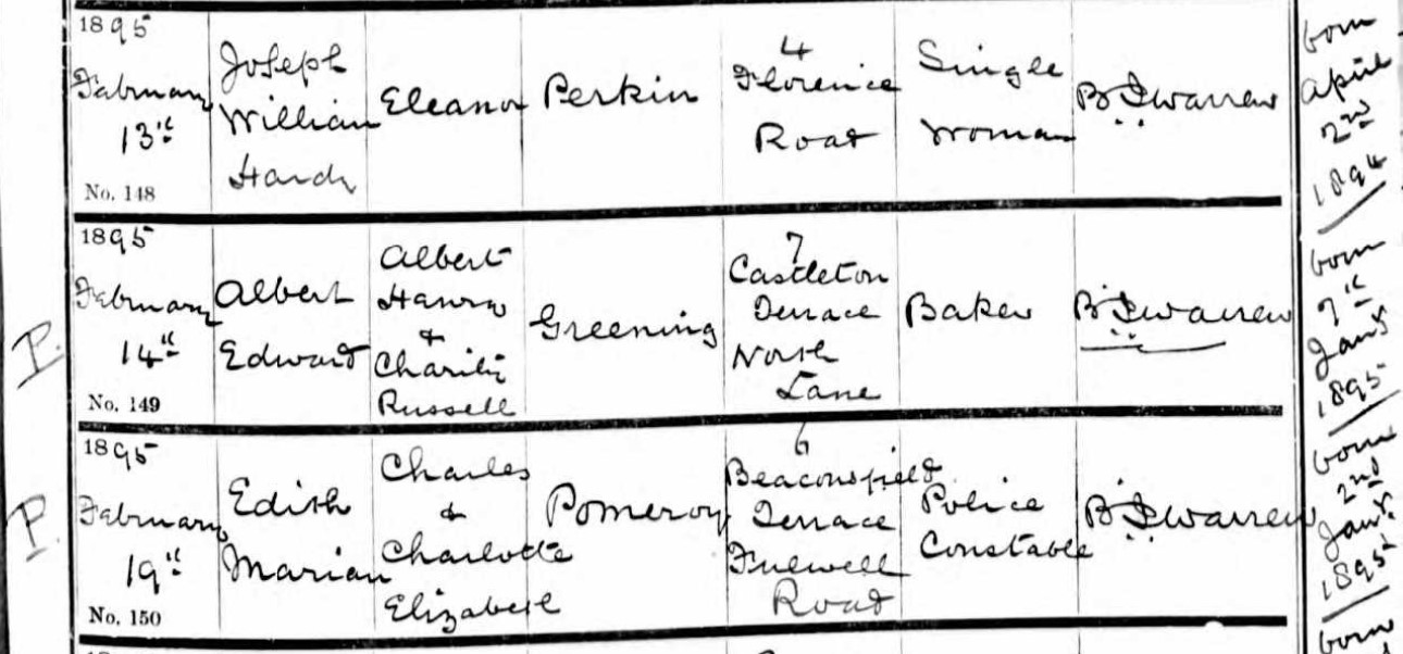
Edith Marrian Pomeroy was born of Charles and Charlotte Elizabeth Pomeroy on 2nd January 1895 and baptised on 19th February 1895 at SS Peter and Paul, Upper Teddington, Middlesex. The entry is annotated with a P, which may indicate Passed, or Plague in a different time.
Sadly, She died in the first Quarter (Jan, Feb, Mar) of 1885, according to the Register of Deaths Index, Kingston. Kingston was also the Registration District for her Birth, also in the first Quarter.
The Registration district of Kingston included Teddington until 1 April 1934 when it became part of the Staines Registration district.
By reference to the London Borough of Richmond upon Thames Cemeteries, burials register, I found this record.
| Deceased name | Edith Mary POMERAY |
| Date of Burial | 19/03/1895 |
| Gender | Female |
| Age | 10 Weeks |
| Date of death | Unknown |
| Location | Teddington Cemetery |
| Section | Ac |
| Grave | 360 |
Duration between birth and burial 10 weeks 6 days.
Baptised as Edith Marian Pomeroy but buried as Edith Mary Pomeray. Two other unrelated children were buried in the same grave, between the 19th and 26th March 1895.
I will use her baptised name going forward.
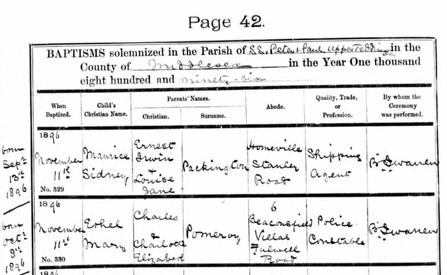
The following year, another daughter. Ethel Mary Pomeroy was born of Charles and Charlotte Elizabeth Pomeroy on 8th October 1896 and baptised on 11th November 1895 at SS Peter and Paul, Upper Teddington, Middlesex.
Abode is still recorded as 6 Beaconsfield Villas, Fulwell Road, and profession as Police Constable.
In 1897 another child was born at their Teddington Home.
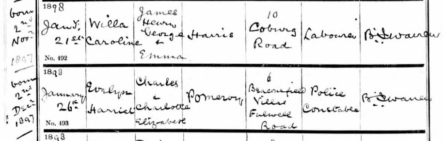
Evalyn Harriet Pomeroy was born of Charles and Charlotte Elizabeth Pomeroy on 2nd December 1897 and baptised on 26th January 1898 at SS Peter and Paul, Upper Teddington, Middlesex.
Queen Victoria dies on 22 January 1901. Queen Victoria was on the throne for the whole of Charles Pomeroy life up until then. He worked for the Queen in the Metropolitan Police, then it changed to a King.
Victoria (Alexandrina Victoria; 24 May 1819 – 22 January 1901) was Queen of the United Kingdom of Great Britain and Ireland from 20 June 1837 until her death. Known as the Victorian era, her reign of 63 years and seven months was longer than that of any of her predecessors. It was a period of industrial, political, scientific, and military change within the United Kingdom, and was marked by a great expansion of the British Empire. In 1876, Parliament voted her the additional title of Empress of India.
Another ten years and another census, on 31 March 1901.
Charles Pomeroy and his family was still living at 6 Beaconsfield Terrace, Fulwell Road, Teddington, Middlesex. He continued as a Police Constable, now aged 46. His wife Charlotte was now 44.
Charles and Charlotte had six children living with them on 31 March 1901. Three from Clerkenwell / Islington, and three from Teddington Middlesex.
- William, aged 16, a Groom (Baptised William Henry on 2nd November 1884)
- Edward, aged 14, a Gardener (Baptised Edward on 6th February 1887)
- Albert, aged 10 (Baptised Albert on 3rd May 1891)
- Emily, aged 8 (Baptised Emily Ellen Gertrude on 3rd March 1893)
- Ethel, aged 4 (Baptised Ethel Mary on 11 November 1896)
- Evelyn, aged 3, (Baptised Evelyn Harriet on 26 January 1898)
![]()
Retirement from the Metropolitan Police Force
Charles Pomeroy had served 25 years as a Police Constable with the Metropolitan Police and was over 48 years old when he retired.
From the National Archives,
The Metropolitan Police Force, created in 1829, was the first modern police force in England (provincial police forces in England and Wales were not established until after the County Police Act of 1839). Its original area of jurisdiction covered a seven-mile radius from Charing Cross in central London. Today it consists of the 32 boroughs of Greater London, excluding the City of London.
Charles Pomeroy joined the Metropolitan Police in 6th May 1878 and started with G Division.
Charles received a Certificate of Service from the Metropolitan Police upon his retirement on 11th May 1903. National Archives MEPO 4/342 Page 65.

On its formation in 1829 the Metropolitan Police District (MPD) was split into seventeen territorial Divisions:
A (Whitehall)
B (Westminster, Later known as Chelsea)
C (St James's)
D (Marylebone)
E (Holborn)
F (Covent Garden)
G (Finsbury)
H (Whitechapel)
K (Stepney, Later known as Bow)
L (Lambeth)
M (Southwark)
N (Islington)
P (Camberwell)
R (Greenwich)
S (Hampstead)
T (Kensington, Later known as Hammersmith)
V (Wandsworth)
Charles started with Division G Finsbury on 6 May 1878 and finished in Division T Hammersmith on 11 May 1908 on Warrant number 62562.
Direct from the National Archives;
 After his retirement more houses were built in the area. From the military record of his son William Henry Pomeroy where Charles and Charlotte are recorded as next of kin, it appears they took advantage of the opportunity provided by the new build, and moved. Just one street away to number 2 Albion Villas, in Prince's Road. In the 1901 Census, on image 26, page 25 of district 17, 1 & 2 Albion Villas are unoccupied and sit between 10 and 4 Prince's Road.
The Military Record address could be 2 Albert Villas, which I have not been able to find yet on Prince's Road Teddington.

It is the same problem as earlier with 6 Beaconsfield Villas, in Fulwell road, with the renumbering of the street from one end to another, instead of a mix of villas and terraces as well as the occasional individual house.
From the Military Record it appears that the new address was recorded in 1905, about half way between the 1901 and 1911 Census.
The photo from Google Streetview is of about 8 and 6 Prince's Road, and is probably more indictive than definitive of where the Charles and his growing family lived Prince's Road.
If this is representative, it is a larger property than the 2 up 2 down in Fulwell Road. The date stone appears to have a P in the shield, for Pomeroy perhaps, or just coincidental, or grasping at straws! The date is unclear.
Prince's Road is on the OS 25" Map of 1895, but only part of one side of the road was developed.
However, since writing the above I have done a lot more research about the location.
(For Supporting Data, follow this link)
The research and the conclusions are available in the above link. Despite what may have appeared in the 1901 Census regarding both the named and the numbered houses, it does not match the renumbering along the length of the street, which seems to have taken place in 1908 and is reflected in the 1909 Register of Voters. So the last photo of houses, albeit Prince's Road, is not relevant, and is in fact on the wrong side of the road.
The South side of Prince's Road was built first and that is where Charles Pomeroy and his family lived.

The first home in Prince's Road was 2 Albert Villas. From the research I have concluded that 1 and 2 Albert Villas, or I and II Albert Villas were renumbered to 21 and 23 Prince's Road in 1908 and the following photo is of those two houses from Google Streetview.
2 Albert Villas, 23 Prince's Road is the one on the right with the blue front door, the wooden fence and the tree in front. They appear to have lived there between approximately 1904 to 1905, before moving to the next block of houses on the left.
 2 Albert Villas, 23 Prince's Road, Teddington, blue door on right
The 2 story houses on the right in the photo below are the same as the photo above.
 1 Albion Villas, 17 Prince's Road, Teddington - Centre block, Left
The move from 2 Albert Villas to 1 Albion Villas was not a great distance. The block was 1 and 2 Albion Villas, unoccupied in the 1901 Census Return, and became 17 and 19 Prince's Road when renumbered.
Charles Pomeroy and family lived here from 1905 to 1910/1911. The had moved to The Prince Albert pub in Colham Green by the 1911 Census.
During the time Charles lived at number 17 Prince's Road he rented two unfurnished rooms on the first floor to Henry Charles Imber, according to the 1907 Register of Voters, for Lodgers, for the sum of 4s 6d per week, £0.225. Relative income value of that income or wealth is £143.60 per week, or £7,526.00 per year, in 2019. This continued in the 1908 and 1909 Registers, although the rent was not declared in those.
In the 1910 Register for Voters, Lodgers, Henry Charles Imber was not listed. Perhaps he had moved with his family to the nearby 14 Coburg Road, Teddington. However, Charles had a new Lodger, Edward Pomeroy, had managed to get on the Electoral Roll by renting a second floor furnished room from his father at 17 Princes Road, for 12s per week, £0.60. Edward was also on the 1911 Register as well as Charles although they moved out after publication of the Book, to The Prince Albert Pub.
Another son, the eldest, William Henry Pomery (Pomeroy) at White Cottage, Wellington Road, Teddington (Hampton Hill postal), just a few minutes walk apart, according to the 1910 Registry of Voters. William's entry immediately below that of Charles
The same for the 1911 Registry, however in the 1912 Registry his father was not included.
Register of Persons Entitled to Vote
A lot of the above information comes from the Register of Persons Entitled to Vote, also known as Register of Voters, as published each year. The relevant extracts were here, but I have moved them to a Supporting Data - Abode Article, to avoid the clutter of so much repetitive data. Follow the link below, and elsewhere in this article to see all the supporting data backing up the information.
(For Supporting Data, follow this link)
This is the introduction was here before I moved the data and is left here as a taster.
Another source of information is the Register of Persons Entitled to Vote. Women were not entitled to vote and only some men, and only in selected elections.
Ownership Electors - Parliamentary and Parochial
Occupation Electors (Other than Lodgers)
- Division one - Persons entitled to vote in Parliamentary, County, and Parochial Elections
- Division two - Persons entitled to vote in Parliamentary and Parochial Elections, but not County Elections
- Division three - Persons entitled to vote in County, and Parochial Elections, but not Parliamentary Elections, and those prefixed with a † are not entitled to vote in Parochial Election either.
Lodgers - Persons entitled to vote in Parliamentary and Parochial Elections,
Our family could be in Fulwell Ward or Upper Teddington Ward
These front pages are similar irrespective of which year in the period. Now for the detail.
Detail moved, follow the link below to find it.
(For Supporting Data, follow this link)
Southern Middlesex and Middlesex history in old Maps
An earlier map gives some context for later in the story. Ordnance Survey First Series, Sheet 7 dated 1856, scale 1:63360 or 1 inch to the mile.


At the bottom of the map is Hampton Court Palace and Kingston, in Surrey, then going North, Teddington, Strawberry Hill, Twickenham, and Hounslow, in Middlesex. North from there is Osterly Park. On the upper map, North West from Osterly Park to Hayes, Colham Green, and Hillingdon.


The above map is from 1897, approximately 40years after the one above it. The roads on the old map have been coloured in, approximately. Click on the map to see it without the colouring and to be able to see the current day underlay.
Fulwell Road and Prince's Road, in fact that whole development, do not yet exist on the old map, and neither does the whole village of Hampton Hill. The Marker on the OS Map is the location of Fulwell Park, or Fulwell Lodge. Visible on both maps, and the probable source of the name for Fulwell Road and the local Railway Station. Strawberry Hill is another estate, about the same degree North but closer to the River Thames, and then across the river is Ham and Richmond Park.
The Estates are being sold of and developed to provide the much needed housing to accommodate the expanding population of London, albeit at this time the area was still Surrey or Middlesex.
The marked Fulwell Lodge, at first owned with Yorke/Fulwell Farm to its north, it dated from the early 17th century.
In the Tithe Apportionment of 24th May 1845 Sir William Clay owned or occupied a large estate in the Parish of Twickenham centred around Plot 455, House Garden & Pleasure Grounds, circled on the Tithe Map below. His Estate in the Parish of Twickenham is colour washed in green, extending to about 300 acres. The estate also extends into the neighbouring parishes.

In 1871 Charles James Freake, a London property developer, bought Fulwell Lodge, its grounds and estate worker's cottages. This extended south from the A316 Chertsey Road and Crane, included the west of later housing often considered Twickenham Green rather than West Twickenham and what became Strawberry Hill Golf Course. It lay north-west of the Shepperton Branch Line encompassing what is now Fulwell Golf Course and as far as Apex Corner where the A312 Uxbridge Road meets the A316. Freake named the area Fulwell Park. After Freake's death in 1884 this passed to his wife, who saw the golf course built in the west, and, on her death in 1900, was held by Freake Estates until 1910. The exiled last King of Portugal, Manoel/Manuel II, bought as his English home Fulwell Lodge from shortly after his marriage in 1913 until his death in 1932.
The lodge and its acres of grounds were then bought by Wates and demolished. It was redeveloped as houses, with some low-rise, landscaped-grounds flats. The history is kept through the names: Manoel Road, Lisbon Avenue, Augusta Road and Portugal Gardens.

Found on the Vision of Britain website, this map shows boundaries and the workhouse Unions, on the OS Sanitary Districts of Middlesex 1888. The Fulwell Lodge Estate, whilst the main house is in Twickenham, extends south possibly into both Hanworth and Teddington. However, exact plots are not confirmed as I have yet to find associated Tithe Maps.
Going further back in time, to the H.M.S.O. Boundary Commission Report 1832.
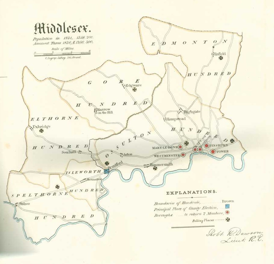
Map of Middlesex, population in 1831, 1358200, and Assessed Taxes in 1830, £1250300. Almost a £1 per head.
The Teddington homes of our family are in the Spelthorne Hundred and the Hillingdon homes are in Elthorne Hundred.
Twickenham, and Fulwell Lodge estate is in Isleworth Hundred.
The principal place of the County Election is Brentford, on the old Roman Road of the Devil's Highway, connecting Londinium (London) to Pontes (Staines) and then Calleva Atrebatum (Silchester). Hounslow also gets a mention on the map.
The road to Staines is now the A30 and A315. with parts bypased by the Great West Road and the Great South West Road.
Uxbridge is shown on another important route including Acton and Southall.

Another H.M.S.O. Boundary Commission Report, this time 1917, and the railways have arrived. Middlesex, or Middle Saxon if going back to the Anglo Saxon times. Many things are similar, but some have changed. The dropping of the use of Hundred, The formation of the County of London.
Hardly any change for centuries then massive change at a pace. The whole area changed by the 1960s.
The Heptarchy (Old English: Seofonrīċe, "seven rikes") is a collective name applied to the seven kingdoms of Anglo-Saxon England (sometimes referred to as petty kingdoms) from the Anglo-Saxon settlement of Britain in the 5th century until the 8th century consolidation into the four kingdoms of Mercia, Northumbria, Wessex and East Anglia.
Over a thousand years before the 1832 Boundary Commission Report Map.
 Anglo Saxon Heptarchy - The penultimate set of Anglo-Saxon Kingdoms was fivefold. The map annotates the names of the peoples of Essex and Sussex taken into the Kingdom of Wessex, (which later took in the Kingdom of Kent and became the senior dynasty) and the outlier kingdoms. From Bartholomew's A literary & historical atlas of Europe (1914)