Tithe Apportionment and Maps
The Tithe Apportionment and associated Maps are a good source of additional information. They do not cover everyone, but they nearly cover everywhere, at a field by field, plot by plot level. The information recorded is stated as being Landowner and occupier, however it appears that, in some instances at least, occupier does not necessarily mean in residence, in the way that it might be interpreted today. On some of the records I have looked at a single person in occupying several properties at the same time. This is understandable for Landowner, but less so for occupier without a slight difference of interpretation, perhaps primary leaseholder. I do have some of the Tithe Maps on CD but not for this area, so these are all from The Genealogist. The OS Maps that might match the detail tend to be the 25 inch Maps, and I find those on the National Library of Scotland Maps.
The Tithe Maps are not, and were never intended to be way finder information. They are there to be read in conjunction with the Tithe Apportionment and appear to be relatively accurate, often with field shapes, for instance, still coinciding with the OS 25" maps and current maps and satellite images. Accordingly, it is sometimes difficult and very time consuming to find and cross reference, or co-locate the relevant position on a Tithe Map to the same place on a OS Map and therefore the definitive Latitude and Longitude. For another area of focus, the Parish of Millbrook, Hampshire, I spent the time to layer the Tithe Map onto Google Earth, and you can look at it here.
It is recognised that as John Bowditch died in 1820, he will not appear in any of the Tithe Maps which are generally prepared about 1840. However, we may be able to locate his children, especially following their inheritance.
If you have a 'The Genealogist' subscription you would be able to use a stated name to search for the relevant entry in the Tithe Apportionment and then onto the Map. It is less easy to do the other way around.
Each map is pertaining to a Parish, and the map is drawn to best fit the page, not with the North Orientation towards the top of the page. This adds to the difficulty of cross location on other mapping as well as searching for people who may be in a different parish.
There are over 350 entries found on a search of the Bowditch surname in the County of Dorset.
So we'll set about researching the Parishes adjacent to Broadwindsor, with Broadwindsor first. Initially focusing on Richard Bowditch, Michael Bowditch, John Bowditch, and Robert Bowditch
Parish of Broadwindsor


An extract from the National Archives
Tithes were originally a tax which required one tenth of all agricultural produce to be paid annually to support the local church and clergy. After the Reformation much land passed from the Church to lay owners who inherited entitlement to receive tithes, along with the land.
By the early 19th century tithe payment in kind seemed a very out-of-date practice, while payment of tithes per se became unpopular, against a background of industrialisation, religious dissent and agricultural depression. The 1836 Tithe Commutation Act required tithes in kind to be converted to more convenient monetary payments called tithe rentcharge. The Tithe Survey was established to find out which areas were subject to tithes, who owned them, how much was payable and to whom.
There are two parts to the Tithe apportionment records, one the Tithe Apportionment Agreement and the other the plan or map identifying the plot(s) of land covered by the agreement. The Apportionment above always has the same columns, probably as laid down by Law and as printed by a limited number of approved printers. The image above includes the column headers as;-
-
-
-
-
- Landowners;
- Occupiers;
- Numbers referring to the plan;
- Name and Description of Lands and Premises;
- State of Cultivation;
- Quantities in Statute Measure, - Acres Rods and Perches:
- Amount of Rent-Charge apportioned on the several Lands and to whom payable;
- Payable to Vicar, - £. s. d.;
- Payable to (hand written), - £. s. d.;
- Remarks
-
-
-
The Impropriator was the Lay person entitled to receive the Rent-Charge 
The maps with the grey background are hand draw by the surveyors engaged in the Tithe Apportionment. The above map is dated 1840 and the orientation is best fit to paper, in this case North approximately to the right of the image.
The other map is of the same location shown on an OS 25" map just over 60 years later. Click on the map to see it at source and the layered current mapping.
There is a Robert Bowditch and a John Bowditch living on the edge of Broadwindsor Parish near Childhay. Literally, cross the road and you would be in the next parish. This is their Apportionment and Map, each with a small black arrow superimposed on the Apportionment. The map has a pop-up for Robert Bowditch and plot 724.
The source of this record, The Genealogist, has the following transcription;-
| Landowner | Robert Bowditch |
|---|---|
| Occupier | Robert Bowditch |
| Parish | Broadwindsor |
| County | Dorset |
| Original Date | 23rd January 1839 |
| Plot | 724 |
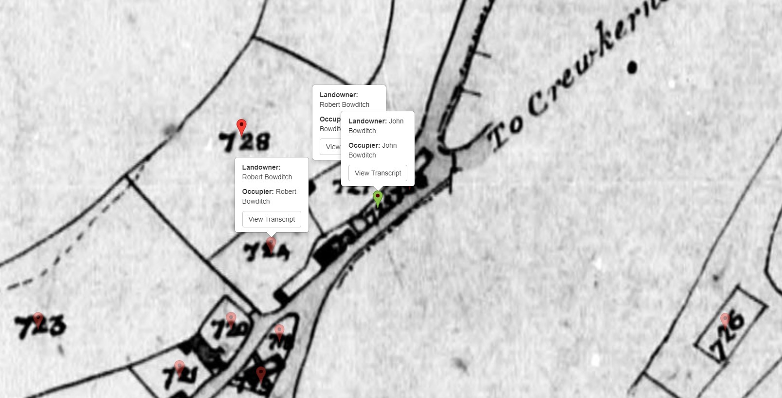
Robert and John owned and occupied adjacent plots described as cottage and gardens. Robert also owned plot 727, another cottage and garden.
The map zoomed in with the three plots showing.
Parish of Crewkerne
In the adjacent parish of Crewkerne, in a later reapportionment, there is mention of another Bowditch, with land straddling the Railway.
The Wood Farm shown on the OS map above is also shown on the 1842 Map. John Henry Henley is the landowner of the nearby Cold Harbour Farm.
| Relationship to Landowner | Executors of |
|---|---|
| Landowner | The Late F H Hooke & the Late R W Bowditch |
| Parish | Crewkerne |
| County | Somerset |
| Original Date | 3rd September 1842 |
Parish of Wayford
The next adjacent Parish is Wayford. In the vicinity of Robert and John Bowditch, Robert Pratt owns Great Greenham Farm. Which is shown as Higher Greenham Farm on the later OS 25" map.
| Landowner | Robert Pratt |
|---|---|
| Occupier | Robert Pratt |
| Parish | Wayford |
| County | Somerset |
| Original Date | 2nd September 1842 |
Parish of Thorncombe
Looking into the parish of Thorncombe we find another pair of Robert and John Bowditch. This time on the outskirts of the village of Thorncombe and a mere 1.7miles, 35 minutes walk away from the other pair at Kittwhistle near Childhay.


Not in the countryside, albeit on the edge of a small village, and not with any significant plot. Just a house and garden each. Being next door to one another, and sharing a Surname, it would not surprise me if they were related. However, they are common names, so as yet there is no evidence that they are the children of our John Bowditch.
This is a case of a Bowditch being a occupier but not the Landowner. Another John Bowditch, farming over 40 acres at Higher Hereditch Farm. The Landowner is William Barker. The Homestead is plot 423, which is the plot identified on the following Tithe Map. His other plots are given a blue wash.


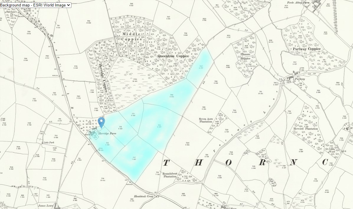
The location of this farm is shown on the OS 25" map, and also shaded in blue. Here you easily see they are the same place by looking at the shape and size of the fields, as well as the position on the two comparative maps.
The farm is called Herridge Farm on the later OS map, and it is still there, on Google Maps at the beginning of 2021, under the same name.
The address is Herridge Farm, Headstock Road, South Chard, Chard TA20 4NJ, even though Chard is just over the county border into Somerset.
Herridge Farm is in the Parish of Thorncombe, Dorset.

Then we find another John Boditch as an occupier. This time with a landlord called Ruth Hallett. Thomas Hallett married Elizabeth Bowditch, one of the children of the John Bowditch, the subject of this article. Another farmer, living at Wakenslade Cottages, School House, Thorncombe, about 15mins walk outside the village of Thorncombe.


This OS map has four potentially different John Bowditch on. Red dots for the two Robert and John Bowditch locations, some blue for the Herridge Farm location, and light green for the latest John, together with some outlying plots. All within a few miles of Thorncombe.
Scooting on through the records of Tithe Apportionments for the County of Dorset, under the surname of Bowditch, without including variants, we find numerous other examples of Bowditch but not of the mentioned children. That is until we get to the parish of Beaminster.
Parish of Beaminster
Richard Bowditch has a house, shop orchard in the town of Beaminster and an allotment.
Of course, this is just a Richard Bowditch. Any link will have to be demonstrated by other information.


The three acre allotment plot is about 1 mile north on the Turnpike towards Crewkerne.
The next find in the Parish of Beaminster is another John Bowditch. Again, not the landlord but the occupier of over 180 acres.


The farm was called Shatcombe Farm and is marked on the OS Map. Click on the map to be able to zoom out and see the extent of the farm in conjunction with the colour washed Tithe Map, and the proximity to the local town of Beaminster.
The same view as the OS map but with the image set to satellite shows the current farm buildings. The marker is in the same place on both.
There are several springs in the vicinity of the Farm House. They combine to form the River Brit. Perhaps the river helps explain the shape of the farm as it follows the river south.

This dip into the Tithe Apportionment records for Dorset does not cover all of the Bowditch surnames for all of the Parishes and may be revisited if necessary to review additional Parishes.
Effectively, although the survey would have taken time to prepare and agree, it was finalised and signed of on a single day, and being focused on money, there was a interest in keeping it up to date and accurate. It can therefore be considered a snapshot in time, in each Parish.
The next time this happened was the 1841 Census.