Fanny Biddlecombe
Fanny Biddlecombe, my 2nd great-grandmother, married William Broomfield, my 2nd great-grandfather on 8 Mar 1854 at St John's Church, Marchwood, Hampshire, England. The Church of St John the Apostle is a Grade II Listed Building, built in 1847, so a relatively new church at the date of their wedding. The church is shown on the Ordnance Survey 25 inch Map Revised: 1895, Published: 1897, then predominantly surrounded by farms and the associated fields. Parish: Marchwood: St John.
Part of the Tithe Map of the Parish of Eling shows Marchwood. A similar view, but rotated N-S, can be seen on the OS 6 inch Map.
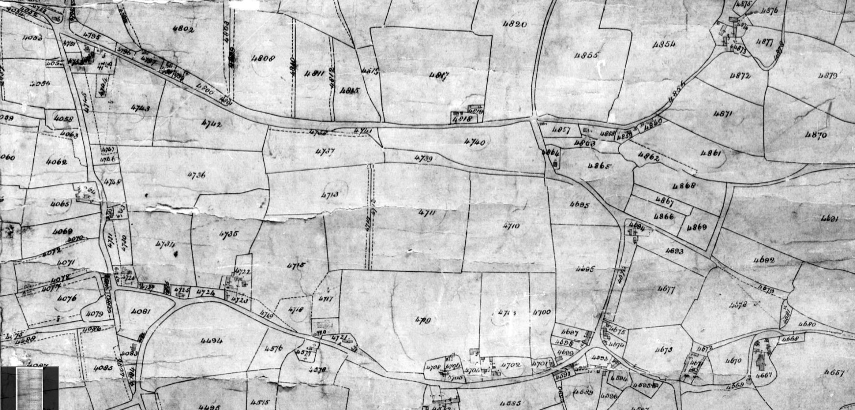
Plot 4818 is described in the Tithe Apportionment Register as Tenements and Gardens, with the adjacent 4819 being Yard and Buildings. Nearby arable fields, Plot 4817 is Travells Lower Ground, Plot 4820 Marchwood Field, Plot 4821 Travells Upper Ground. These plots, together with many others in the area are occupied by Arnold White with the Landowner being recorded as Sir John Barker Mill Baronet. The same as the principle landowner in the Parish of Millbrook. The date of the map was recorded as 12th June 1843. The field sizes and associated Tithe Apportionment are;
| Description of Land | Tavells Lower Ground | Marchwood Field | Tavells Upper Ground | Total holdings of Arnold White with landloard Sir John |
|---|---|---|---|---|
| Quantities In Statute Measure A.R.P |
8,2,3 | 7,3,22 | 5,0,14 | 267,1,25 |
| Plot | 4817 | 4820 | 4821 (above 4817) | |
| Payable to Vicar £sd | £0 9s 6d | £0 10s 6d | £0 6s 0d | £17 5s 0d |
| Payable to Lady | £2 2s 6d | £2 6s 0d | £1 7s 0d | £53 0s 0d (£73,400.00 - 2019) |
Plot 4844 is described as Farm House and offices, and could be his residential home. Bury Farm on the OS maps.
The record for an adjacent plot on the Tithe map, but no longer on the OS maps;
| Landowner | Lady Selina Mill |
|---|---|
| Occupier | Lady Selina Mill |
| Parish | Eling |
| County | Hampshire |
| Original Date | 12th June 1843 |
| Description of Land | Mansion and Offices |
| Quantities In Statute Measure | 0,1,22 |
| Plot | 4847 |
Bury Farm House is a listed building, but I am not sure if that is plot 4844 or 4847.
Plots 4818 and 4819 combined are probably shown on the OS maps as Travel's Farm and the name Travel's Lane probably derives from the farm and nearby field names. Losing an l and gaining an apostrophe in the process, before reverting back in the current maps.
In the 1911 Census Fanny Broomfield, aged 76, a widow is living with her son Alfred Broomfield, 44 and his wife Kate, at Travells Farm, Marchwood. Fanny, in the infirmity column is recorded as have Cancer 2 years ago, 1909. Also listed is Sidney Parker, 19, single, Son in Law. The Census records that no children have been born to Kate in the marriage to Alfred. It therefore follows that Sidney, is a Son in Law from a previous marriage, with surname Parker. Kate is shown as being 44 and 7 years in current marriage, making her about
Alfred is a Labourer at H.M. Magazine. By reference to the OS maps and the Tithe Map, the Magazine is at the end of Magazine Lane, Marchwood. Albeit the Tithe Map is 1843, and the Census is 1911, it appears to be the same place.
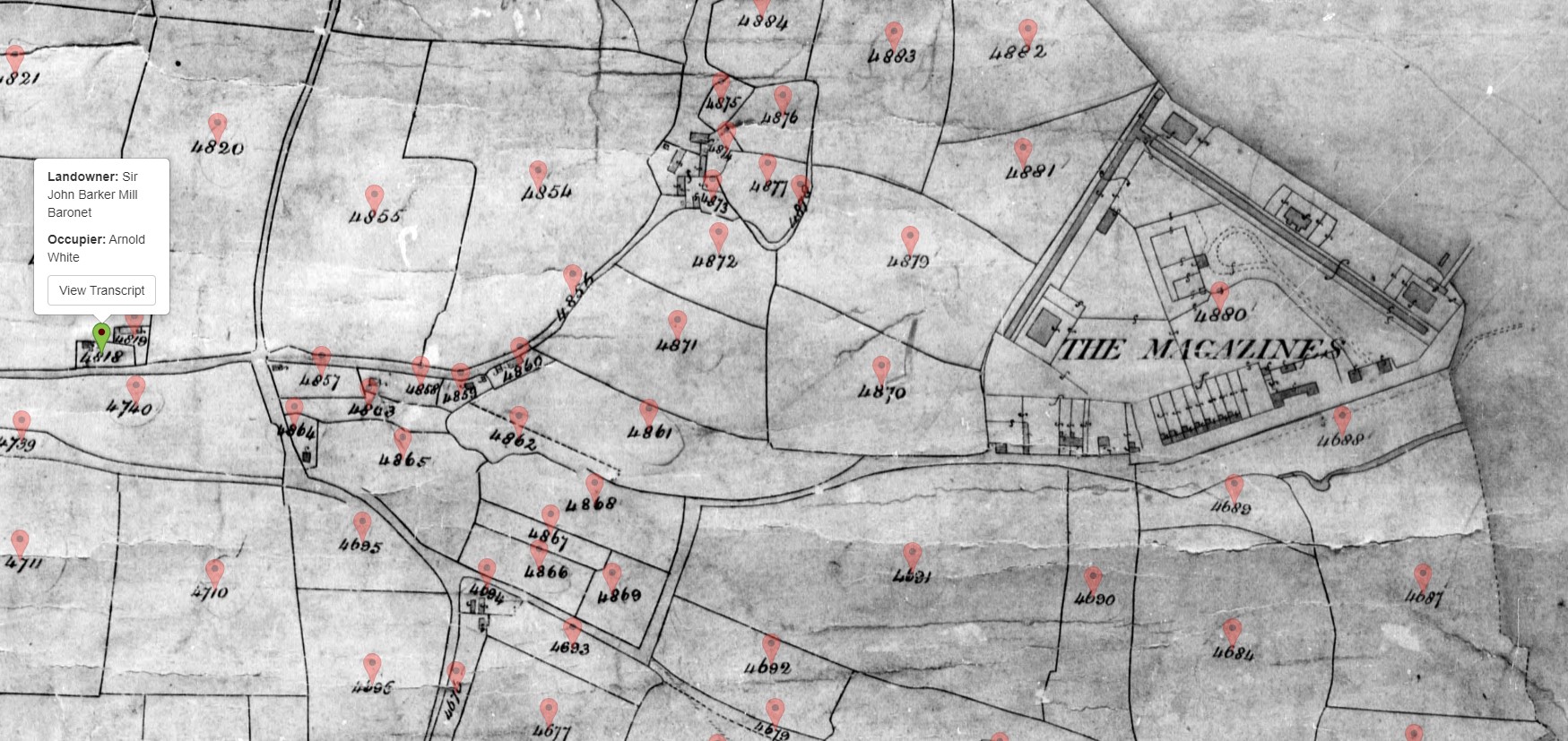
The tithe map shown is from The Genealogist and the white popup on the left is Plot 4818, Travel's Farm, with the Magazines clearly shown on the shoreline on the right.
On the OS maps of the time, only the housing along the lane is shown, not the Magazines or Blast Wall. Anecdotally, for a very long time, until relatively recently, anything military or secret was left off of OS maps as white space. Thereby avoiding passing intelligence on to the enemy, regarding location and layout. The Magazine was a Royal Naval Armaments Depot and therefore fell into that category of white space.
The Magazine is now developed as housing with part occupied by the Marchwood Yacht Club. One of the roads in the development is Ordnance Way, a nod to its history.
An extract from Historic England Research Reports. Download the whole of the report here.
Marchwood Gunpowder Magazines were built at the end of the Napoleonic Wars by the Board of Ordnance. The first phase, consisting of three magazines, a barracks and related buildings, was completed in 1816. Each magazine could hold almost 7,000 barrels of gunpowder. The site on the west shore of Southampton Water was chosen for its remoteness, its security and its proximity to Portsmouth. The magazines consisted of ventilated brick walls and roofs of slate and tile: they did not follow the conventional design of magazines, which had heavy vaulted roofs of brick which rendered them bombproof. Only one magazine, several perimeter walls and a number of depot buildings remain from this phase.
The Magazines declined in use until the outbreak of the Crimean War. A second phase of magazine construction took place in the mid-1850s, which added an extra four magazines to the existing three. One of these survives almost intact. Marchwood thus became the largest gunpowder storage depot in the country.
With the decline of gunpowder, Marchwood came to be used for the storage of small calibre ammunition. A bombing raid in 1940 led to the destruction of five of the seven magazines. These were rebuilt in 1941-2. The depot finally closed in 1961, when the more recent magazines were demolished. A scheme to widen Southampton Water, which would have led to the loss of many of the structures, was averted. Several buildings were scheduled in 1968. The site was sold off by the Ministry of Defence in the mid-1980s, by which most of the surviving buildings were in poor condition.
The depot is of considerable interest as a rare purpose-built gunpowder storage facility. The layout of the depot and the construction of the only partly-surviving magazine were both iimovatory in their day. Marchwood is an important site as a reminder of Hampshire's contribution to the nation's defences.
As an aside, another relative worked in Gunpowder Magazines, but in Chattenden and Lodge Hill Military Camps, Upnor, Kent.
A quick view of Marchwood, posted on Facebook, together with some of the comments.
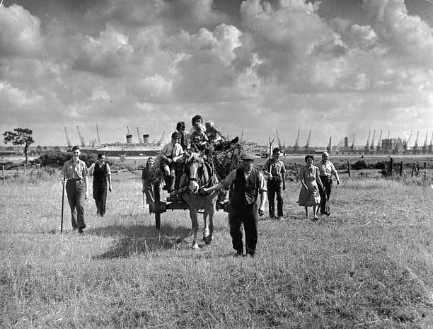 4th September 1948: A farmer near Southampton brings his harvest in with the help of holidaymakers who had come to see the ship, the Mauretania. Original Publication: Picture Post.
Ian Harden -
Difficult to imagine this now. A fine image
Glenys Freeman -
Teds dad Jack said when he was putting roofs on the houses at shirley warren, there was a farmer in the fields next to the houses, with his tractor pulling a bailer.
Jeanne Mayer -
Rod Andrews Yes, it was the Dunning/Maton family. This was in Magazine Lane and the power station was built there. The family moved to Warwick Farm in Cracknore Hard Lane. I think most of the people were part of the extended family as everyone helped out at harvest time.
 The colourised version by Ian Hepplewhite
Back to the Tithe Map;
| Landowner | Margaret Saunders |
|---|---|
| Occupier | John Biddlecombe |
| Parish | Eling |
| County | Hampshire |
| Original Date | 12th June 1843 |
| Description of Land | House and Garden |
| Quantities In Statute Measure | 0,1,12 |
| Plot | 4577 |
This John Bibblecome is the same one listed near to Marchwood Farm in the 1841 Census. Perhaps Marchwood Farm is Marchwoodgreen Farm on the OS Maps. Plot 4577 is on Main Road, Marchwood, near the Church, on the opposite side of the road.
The family on the 1841 Census are:
|
Name
|
Age
|
Estimated Birth Year
|
Gender | Birth County | Birth Country | Location | Not on Census / assumed relationship |
|
John Biddlecome
|
50
|
1791
|
Male
|
Hampshire
|
England
|
Parish of Eling, Tything of Marchwood, Marchwood | Head |
|
Elizabeth Biddlecome
|
40 |
1801
|
Female
|
Hampshire | England | Parish of Eling, Tything of Marchwood, Marchwood | Wife |
|
Henry Biddlecome
|
11
|
1830
|
Male
|
Hampshire | England | Parish of Eling, Tything of Marchwood, Marchwood | Son |
|
Charles Biddlecome
|
8 |
1833
|
Male
|
Hampshire | England | Parish of Eling, Tything of Marchwood, Marchwood | Son |
|
Fanny Biddlecome
|
6 |
1835
|
Female
|
Hampshire | England | Parish of Eling, Tything of Marchwood, Marchwood | Daughter |
|
Maria Biddlecome
|
4 |
1837
|
Female
|
Hampshire | England | Parish of Eling, Tything of Marchwood, Marchwood | Daughter |
|
William Biddlecome
|
1
|
1840
|
Male
|
Hampshire | England | Parish of Eling, Tything of Marchwood, Marchwood | Son |
|
Elizabeth Oliver
|
70
|
1771
|
Female
|
Hampshire | England | Parish of Eling, Tything of Marchwood, Marchwood | Mother in Law |
Elizabeth Oliver (nee Jeram) is listed on both 1841 and 1851 Census, and on the latter descrided as a Pauper, widow of Agriculture Labourer, and as being deaf. Her birth county on both is Hampshire.
Searching The Genealogist for surname Biddlecombe in the Parish of Eling led to an extraordinary number of results.
| Landowner | Occupier | Location | Lat & Long (click for link to NLS OS Map) | Census - 6 Jun 1841 | ||||||
|
Name: Stephen Biddlecombe |
Name: Stephen Biddlecombe
|
Main Road, Hounsdown, Totton | 50.904670,-1.500831 |
Stephen Bittlerady on Ancestry - Transcription error District 13b Page 14 Age 50 |
||||||
| Name: Leonard Biddlecombe Parish: Eling... County: Hampshire... Type: Landowner... Plan Number: 3488... |
Name: Leonard Biddlecombe
|
Colbury, Deerleap Lane, Ashurst | 50.897687,-1.505744 |
Houndsdown District 8b, Page 7 Age 65 |
||||||
| Name: Robert Biddlecombe Parish: Eling... County: Hampshire... Type: Landowner... Plan Number: 3487... |
Name: Robert Biddlecombe
|
Colbury, Deerleap Lane, Ashurst | 50.897382,-1.505777 |
Houndsdown District 8b, Page 7 Age 55 |
||||||
| Name: Daniel Biddlecombe Parish: Eling... County: Hampshire... Type: Landowner... Plan Number: 3436... |
Name: Daniel Biddlecombe
|
Deerleap Lane, Ashurst | 50.889485,-1.509049 |
District 8b, Page 9 Age 65 |
||||||
| Name: Thomas Biddlecombe Parish: Eling... County: Hampshire... Type: Landowner... Plan Number: 370... |
Name: Thomas Biddlecombe
|
Knellers Lane, Ashurst | 50.903323,-1.506399 |
District 8b, Page 13 Age 45 or 65 |
||||||
| Name: Edward Biddlecombe Parish: Eling... County: Hampshire... Type: Landowner... Plan Number: 4455... |
Name: Edward Biddlecombe
|
Beacon Hill, Twiggs Lane, Marchwood |
50.882331,-1.454300 |
District 10, Page 8 Age 70 |
||||||
| Name: James Biddlecombe Parish: Eling... County: Hampshire... Type: Landowner... Plan Number: 3402... |
Name: James Biddlecombe
|
Lyndhurst Road / Farm Lane, Ashurst | 50.893457,-1.518866 |
District 8b, Page 4 Age 40 |
||||||
| Name: James Biddlecombe Parish: Eling... County: Hampshire... Type: Landowner... Plan Number: 4456... |
Name: James Biddlecombe
|
Beacon Hill, Twiggs Lane, Marchwood |
50.882595,-1.454107 |
District 10, Page 8 Age 40 |
||||||
| Frederick Charles Wilson Esquire |
Name: Isaac Biddlecombe & and Another
|
Chapel Lane, Ashurst Bridge / Hounsdown | 50.907329,-1.503998 |
District 13b Page 18 Age 40 |
||||||
| Philip Andrews |
Name: During Biddlecombe
|
|||||||||
| Philip Andrews |
Name: During Biddlecombe
|
Hag's Lane / Arters Lawn, Marchwood | 50.877291,-1.471125 |
Duran / Durin District 9a Page 5 Age 52 |
||||||
| Sir John Barker Mill Baronet |
Name: Joseph Biddlecombe
|
|||||||||
| Sir John Barker Mill Baronet |
Name: Joseph Biddlecombe
|
Pound Lane, Hounsdown | 50.898137,-1.498017 | |||||||
| Margaret Saunders |
Name: John Biddlecombe
|
Main Road, Marchwood | 50.889654,-1.453165 |
District 10a, Page 32 Tithing of Marchwood Age 50 |
||||||
| Aaron Taylor |
Name: George Biddlecombe
|
Deerleap Lane, Long Down, Marchwood | 50.881336,-1.490620 |
District 8b Page 12 and Page 26 Tithing of Langley Age 25 |
||||||
| George Bundy |
Name: William Biddlecombe
|
Deerleap Lane, Ashurst | 50.888016,-1.506262 | |||||||
| George Bundy |
Name: William Biddlecombe
|
|||||||||
| George Bundy |
Name: William Biddlecombe
|
|||||||||
| William Sloane Stanley Esquire |
Name: William Biddlecombe
|
|||||||||
| William Sloane Stanley Esquire |
Name: William Biddlecombe
|
Copythorne Common, Cadnam | 50.936051,-1.565330 | |||||||
| William Sloane Stanley Esquire |
Name: William Biddlecombe
|
|||||||||
| William Sloane Stanley Esquire |
Name: William Biddlecombe
|
I have tried to link the Bibblecombe people from the Tithe Apportionment listed above to their respective 1841 Census entry, mainly, in addition to their name, by the location. The Tithe Map gives an accurate location, generally much more so than the enumerators recording. Sometimes it is a case of matching a nearby prominent house with the person's name on both the Tithe Map and the Census and then step along the route looking for other similarities, then using proximity to confirm the Census entry to that of the Title Apportionment. The Tithe Apportionment only has two names associated with a plot, the landowner, and the occupier. By observation of the records, occupier is unlikely to be exclusively the occupier of a particular dwelling in the way the census records it, or how we may interpret it today. Occasionally the Tithe records state that an occupier has several dwellings, sometimes with different Landowners, which suggests that 'Occupier' should perhaps be interpreted as 'Primary Leaseholder'. Think of a farmer, renting his farm from the local squire. The farm has many dwellings occupied by the families of the farmers agricultural labourers and other workers. They appear to be occupied by the farmer, from the Tithe Map, not the Agg Lab. Conversely, the Census records the Agg Lab and not the Farmer. Hence numerous inconsistencies, on the path between matching names and our person of interest.
Once the Tithe Apportionment person has been identified in the Census, his family are also located at Tithe Map accuracy. For some static families that place is from birth to death.
Another source of location information is from Knightsroots, a website that includes Parish Records, and in our case Baptisms in the Parish of Eling. Other websites have baptism records, but generally with less transcribed information. The additional information is useful.
Below is a map, initially, of the named individuals listed above in the Tithe Apportionment.
A Church of England current map of the Parishes.
The ancient parish of Eling included the modern parishes of Eling, Netley Marsh, Copythorne, Colbury and Marchwood, the four latter parishes being formed from Eling in 1894. The inclosure award for Eling is dated 30 November 1814
In addition to this research I have started a One Name Study for Biddlecombe and variants. This can be found at my TGN site for Biddlecombe.
Now, at the risk of being boring and tedious let us explore James Biddlecombe. There are two listed in the Tithe Apportionment above. We have already concluded that this could be the same person with multiple holdings. Both James listed are Landowner and Occupier of Cottage and Garden. The two properties are just shy of 3 miles apart as the crow flies. Much further on foot. Over 4 miles and 1 hr 21 mins walking time according to Google maps. Via Deerleap Lane, past other Biddlecome's residences, so perhaps much longer depending on the number of cups of tea.
One of the James is clearly living at Beacon Hill in both the Tithe Map of 1843 and the 1841 Census. He is also living adjacent to Edward Biddlecombe in both. From the Census information Edward is older than James, 70, and 40. Therefore it is possible the James of Beacon Hill could be the son of Edward, and I have made that assumption, hoping to have it confirmed by Baptism and Marriage records in due course.
Searching the 1841 Census for James Biddlecombe there are indeed two entries for that name, both aged 40, but at different locations. The one at Beacon Hill as previously mentioned, the other at Hounsdown, which is much less definitive. Inspection of the Census on nearby pages to James of Hounsdown does not reveal any defining locations. So, next it is looking for nearby names coexisting in both the Census and Tithe Map. Charles Bell, is one such name, the occupier of Land owned by The Lords Commissioners of Woods & Forests in plot 3406, a Cottage and Garden. Less than 400 yds away, at the end of Farm Lane, adjacent to Ashurst Farm. A count of two buildings away on the Census. That, I think is sufficient to link the James of plot 3402 to the James of Hounsdown in the Census. As an aside, Ashurst Farm is Owned and occupied by The Reverend William Joseph George Phillips according to the Tithe Apportionment. He is found at Eling Vicarage in the 1841 Census.
Recorded at the same residence in the 1841 Census was a Hannah Biddlecombe or Biddlecome, age 85, which results in an estimated year of birth of 1756. There is a James Biddlecombe already in my tree, with parents John Biddlecombe b 1759 and Hannah Biddlecombe nee Hatch. His birth is 1798, three years different from the estimate of 1801 in the 1841 Census. However, the ages given to the Enumerator are not always correct. The person does not always know how old they are, and sometimes they have reason to misinform. The reason can be as little as keeping the wife and husbands age similar. The ages would have prevented me from making a link, but having Hannah in the same building gets me into hypothesis mode, an perhaps she is his widowed Mother. She is of the right age, and the name matches. Hopefully there will be some more information to confirm this hypothesis.
There is a Harriot Biddlecomby (according to the Ancestry transcription) corrected to Harriot Biddlecombe, aged 30, working as a Female Servant, in the home of Elizabeth Abraham. Which just happens to be next door to Isaac Biddlecomby / Biddlecombe, a game keeper. I have Isaac as being a younger brother to James in my tree. Isaac's location also matches the Isaac above in the Tithe List, at Chapel Lane, Ashurst Bridge / Hounsdown. Another set of coincidences.
Wife
It is not a surprise to me that I felt the need to create a spreadsheet recording all the Census information in the Parish of Eling from 1841 to help establish the extent and details of the Bibblecombe and variations. Initial analysis gives a total of 95 people with the variations of the surname across 8 Census sub-districts;-
| Enumeration District | Surname | Count of Surname -Total |
|---|---|---|
| 8a | Biddlecombe | 14 |
| 8a Total | 14 | |
| 8b | Biddlecomb | 16 |
| Biddlecome | 7 | |
| Bodddlecomb | 3 | |
| Riddlecomb | 7 | |
| 8b Total | 33 | |
| 9a | Biddlecombe | 5 |
| 9a Total | 5 | |
| 10 | Biddlecombe | 15 |
| 10 Total | 15 | |
| 10a | Biddlecome | 7 |
| 10a Total | 7 | |
| 11 | Biddlecome | 1 |
| 11 Total | 1 | |
| 12a | Biddlecomb | 4 |
| 12a Total | 4 | |
| 13b | Biddlecombe | 1 |
| Biddlecomby | 14 | |
| Bodlcomb | 1 | |
| 13b Total | 16 | |
| Grand Total | 95 |