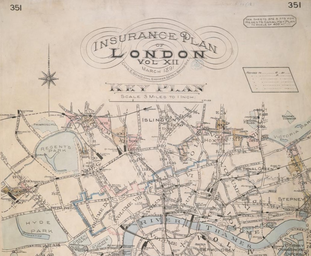
Places of Interest
{slider title="St Mary's Church"}
{slider title="Middle Road Sholing"}
Sholing
Sholing, Bitterne, Hampshire
Domesday Book
There appears to be no mention of Sholing in the Domesday Book, at least in that form of spelling. However there is an entry for Hound.
Hound was a settlement in Domesday Book, in the hundred of Mansbridge and the county of Hampshire.
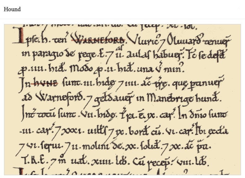
It had a recorded population of 23 households in 1086, putting it in the largest 40% of settlements recorded in Domesday (NB: 23 households is an estimate, since multiple places are mentioned in the same entry).
The image is an extract of the Domesday Book, fortunately transcribed for us.
Land of Hugh of Port
Households
Households: 31 villagers. 9 smallholders. 6 slaves.
Land and resources
Ploughland: 9 ploughlands. 3 lord's plough teams. 6 men's plough teams.
Other resources: Meadow 20 acres. 2 mills, value 1 pound. 1 church.
Valuation
Annual value to lord: 14 pounds in 1086; 8 pounds when acquired by the 1086 owner; 14 pounds in 1066.
Owners
Tenant-in-chief in 1086: Hugh of Port.
Lord in 1086: Hugh of Port.
Overlord in 1066: King Edward.
Lords in 1066: Wulfric; Wulfward.
Other information
This entry mentions multiple places: Hound; Warnford.
Phillimore reference: Hampshire 23,18
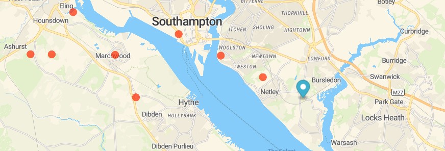
The map marks the location of Hound from the Domesday Book entry, and the suburb of Sholing in the modern Southampton. Hound is not the nearest dot on the map. Netley and Woolston, also have entries.
Netley was a settlement in Domesday Book, in the hundred of Mansbridge and the county of Hampshire.
It had a recorded population of 13 households in 1086.
Land of Richard Poynant
Households
Households: 9 villagers. 2 smallholders. 2 slaves.
Land and resources
Ploughland: 5 ploughlands. 1 lord's plough teams. 2 men's plough teams.
Other resources: Meadow 4 acres. Woodland 40 swine render. 1 church.
Valuation
Annual value to lord: 5 pounds in 1086; 2 pounds when acquired by the 1086 owner; 3 pounds in 1066.
Owners
Tenant-in-chief in 1086: Richard Poynant.
Lord in 1086: Richard Poynant.
Overlord in 1066: King Edward.
Lord in 1066: Alward.
Other information
Phillimore reference: Hampshire 42,1
Woolston was a settlement in Domesday Book, in the hundred of Mansbridge and the county of Hampshire.
It had a recorded population of 6 households in 1086, putting it in the smallest 40% of settlements recorded in Domesday.
Land of Reginald (Cnut)
Households
Households: 3 villagers. 3 smallholders.
Land and resources
Ploughland: 1 men's plough teams.
Valuation
Annual value to lord: 5 shillings in 1086; 10 shillings in 1066.
Owners
Tenant-in-chief in 1086: Reginald (Cnut).
Lord in 1086: Reginald (Cnut).
Overlord in 1066: King Edward.
Lord in 1066: Tovi.
Other information
Phillimore reference: Hampshire 59,1
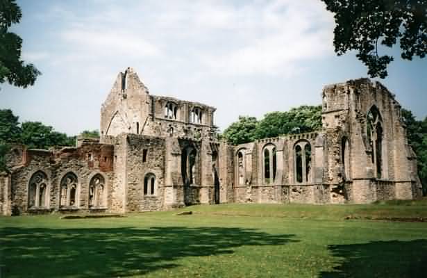
The abbey of Netley
The abbey of Netley, Letley (Lœtus Locus), or Edwardstow (Loci Sancti Edwardi), dedicated to the honour of the Blessed Virgin and St. Edward the Confessor, was founded for Cistercian monks by Henry III. in 1239. It appears that Peter des Roches, Bishop of Winchester (1205-38), purchased the land of ' Hanseta ' and ' Cedrigia' from William, Bishop of Angers, and the dean and chapter of Angers; lands in Wellow from the abbot of St. Mary de Pratis, Leicester; lands at Kingston Deverel from the bishop and chapter of Le Mans; land called 'Ayhsleg' in Dorsetshire from the abbot of Croix St. Leufroy; and some other parcels of land, apparently with the object of founding this monastery. The bishop, however, died in 1238, before the completion of his object, and the actual foundation was carried out by Henry III. in the following year. Hence the king was usually referred to as the founder. So soon as the monastery was completed it was colonized by monks from the Cistercian abbey of Beaulieu, who arrived at their new home on St. James' Day, 1239.
In August, 1243, Roger de Clare sold to the abbey for 300 marks the tilled land and pasture which lay between their manor of Gomshall and the highway from Guildford to Dorking, and also the advowson of the church of Shere, which grant was confirmed by John de Warren, Earl of Surrey, in 1252.
In 1244 Innocent IV. sanctioned Under certain conditions the appropriation by the abbey of Netley of the churches of Shere and Wellow, valued at £30 per annum. The same pope in the following year confirmed to the abbot and convent of Netley the privileges of not being compelled by bishops or others to attend synods or assemblies outside their order, save only pro fide, and of exemption from sentences of excommunication, suspension or interdict.
In the same year Robert, abbot of Netley, released to the Bishop of Winchester the manor of Esher, with the advowson of the church and all its appurtenances, save 100s. worth of land in Dorsetshire. In August, 1247, the abbot and convent of Lieu Dieu, in the diocese of Amiens, sold to the abbey of Netley for 600 marks their English manor of Nordley, their rents in Oxford, their rents and rights in Chaddleworth and their rent of five marks from the church of Henton.
Henry III. on 7 March, 1251, confirmed to Netley Abbey (Sancte Marie de Loco Sancti Edwardi) the site of the monastery with the lands of Netley, Hound, Wellow, Totton, Gomshall, Nordley, Kingston Deverel, Waldon, Aynsley and Lacton, with rents in Charleton, Southampton and Southwark, a hundred acres in Shere manor and the church there, as well as many liberties and privileges. A fortnight later the king granted to the abbey free warren on their lands in Netley, Hound, Shotteshale, Westbrook and Sholing (Hants), Waddon and Aynsley (Dorset), and Gomshall and Shere (Surrey), a weekly market at Hound on Monday and a two days' fair at Wellow on the vigil and day of St. Margaret. Henry III. continued his benefactions to the abbey, and on 24 July, 1253, granted to it three carucates of land, of 100 acres each, in the New Forest, with licence to enclose and cultivate them; and in 1256 he gave special licence to enclose the same against the king's deer. He also further granted to the abbey a tun of wine yearly out of the prisage at Southampton, to be used for the celebrations in the abbey. Edward I. instructed the taker of the king's wines at Southampton in 1276, 1277 and 1280 to duly supply this wine according to the late king's charter; but in 1281 Edward I. granted 20s. yearly in alms in lieu of the wine, as the prisage at Southampton was assigned to Eleanor, the king's mother, as part of her dower.
... (jumping forward a few centuries)
A royal commission was issued in 1535, which empowered Thomas, abbot of Forde, to visit various Cistercian houses, including Netley and all those of Winchester diocese.
The Valor of 1535 estimated the gross revenue of Netley Abbey at £160 2s. 9½d., whilst the clear income was only £100 12s. 8d.; it therefore came under the heading of the lesser monasteries. Being of exempt jurisdiction, no particulars are given in the return.
On 30 May, 1536, Sir James Worsley and his brother commissioners presented their report on the religious houses of Hampshire. Netley is described as 'A hedde house of Monkes of thordre of Cisteaux, beinge of large buyldinge and situate upon the Ryvage of the Sees. To the Kinge's Subjects and Strangers travelinge the same Sees great Relief and Comforte.' The commissioners estimated its total revenues at £181 2s. 8d. They found there seven monks, all priests, ' by Raporte of good Religious conversation, whereof desieren to Contynne Religiar vj, and to have capacite j.' There were thirty-two other inmates, namely ' ij freeres observantes comytted by the Kinge's highnes,' four waiting servants, four officers of the household, eleven officials of the convent, seven hinds and three ' for the dayery.' The church, mansions and buildings were in good repair. The lead and bells were worth £57; plate and jewels, £43 2s. 11d.; ornaments, £39 4s. 8d.; stuff, £9 3s. 4d.; corn, £10 17s.; stocks and stores, £103 13s. 4d. The woods were worth £81. The debts of the house were £42 3s. 4d., but there was £28 5s. owing to the house.
The abbey of Netley retained most of its early endowments, and at the time of its dissolution the lands belonging to it were, besides the site, the manors of Wellow, Totton, Roydon, Nordley, Gomshall, Kingston Deverel and Hound; and lands and possessions in Southampton, West Setley, Mitcomb Regis, Charleton, Shottishale, Sholinge and Shamelhurst.
On 3 August, 1536, the king gave to Sir William Poulett, the comptroller of his household (two of whose brothers had been the commissioners who reported so favourably of this house in the previous May), the site and buildings of the suppressed abbey, together with the grange, mill and lands in Netley; the manor of Hound; lands and windmill, etc., in Hound and Sholing; the manor of Townhill; lands, etc., in Townhill and Shamelhurst; and the manor of Waddon and the farm of Aisheley in Dorsetshire. The manor of Kingston Deverill (Wilts) was bestowed on Sir Edward Seymour in the following year. The reversion and rent reserved upon a lease granted in 1502 by Abbot John Burges of the manor of Gomshall, Surrey, was given in 1538 to Sir Edward Braye. The tithes of Wellow rectory and land there were granted in 1539 to Sir Richard Lyster, chief baron.
The English Reformation
The English Reformation took place in 16th-century England when the Church of England broke away from the authority of the Pope and the Roman Catholic Church. These events were, in part, associated with the wider European Protestant Reformation, a religious and political movement that affected the practice of Christianity in western and central Europe. Causes included the invention of the printing press, increased circulation of the Bible and the transmission of new knowledge and ideas among scholars, the upper and middle classes and readers in general. The phases of the English Reformation, which also covered Wales and Ireland, were largely driven by changes in government policy, to which public opinion gradually accommodated itself.
The break with Rome was affected by a series of Acts of Parliament passed between 1532 and 1534, among them the 1534 Act of Supremacy, which declared that Henry was the "Supreme Head on earth of the Church of England" (this title was renounced by Mary I in 1553 in the process of restoring papal jurisdiction; when Elizabeth I reasserted the royal supremacy in 1559, her title was Supreme Governor). Final authority in doctrinal and legal disputes now rested with the monarch; the papacy was deprived of revenue and the final say on the appointment of bishops.
Another view of the English Reformation
Dissolution of the Monasteries (and Abbeys)
The Reformation in Tudor England was a time of unprecedented change. One of the major outcomes of the Reformation was the destruction of the monasteries which began in 1536.
The Reformation came about when Henry VIII wished to divorce his first wife, Catherine of Aragon, who had failed to give him a male heir. When the Pope refused to grant the divorce, Henry set up the Church of England. The Act of Supremacy in 1534 confirmed the break from Rome, declaring Henry to be the Supreme Head of the Church of England.
The monasteries were a reminder of the power of the Catholic Church. It was also true that the monasteries were the wealthiest institutions in the country, and Henry’s lifestyle, along with his wars, had led to a lack of money. Monasteries owned over a quarter of all the cultivated land in England. By destroying the monastic system Henry could acquire all its wealth and property whilst removing its Papist influence.
The idea was not new. Thomas Cromwell had already helped Cardinal Wolsey dissolve monasteries in the past. First of all, a dossier was presented to Parliament outlining the corrupt morals of the clergy. Henry’s chief minister Cromwell then introduced the ‘Valor Ecclesiasticus’ to find out just how much property was owned by the Church. He sent out royal commissioners to all the monasteries in England, Wales and Ireland.
This led to the Act of Suppression in 1536 whereby small monasteries with an income of less than £200 a year were closed and their buildings, land and money taken by the Crown. The Second Suppression Act of 1539 allowed the dissolution of the larger monasteries and religious houses.
Monastic land and buildings were confiscated and sold off to families who sympathised with Henry’s break from Rome. By 1540 monasteries were being dismantled at a rate of fifty a month.
After the disposal of their monastic lands and buildings, the majority of monks, friars and nuns were given money or pensions. However, there were some abbots and religious house leaders who refused to comply. They were executed and their monasteries destroyed. Thousands of monastic servants suddenly found themselves without employment.
A bit circuitous, but it appears that from the initial growth and spread of influence following Netley Abbey's creation, upon the dissolution of the Abbey, Sholing came under the control of Sir William Poulett,
Shortly after the Dissolution of Netley Abbey, we have Saxton's map of Hampshire, 1575. Below is a extract.
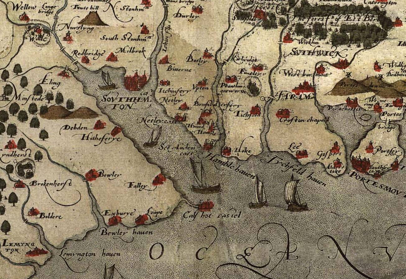 Extract from Christopher Saxton Map - Map, hand coloured copper plate engraving, Southamtoniae, ie Hampshire, scale about 4 miles to 1 inch, engraved by Leonard Terwoort, Antwerp, Netherlands, published by Christopher Saxton, map maker, London? about 1575
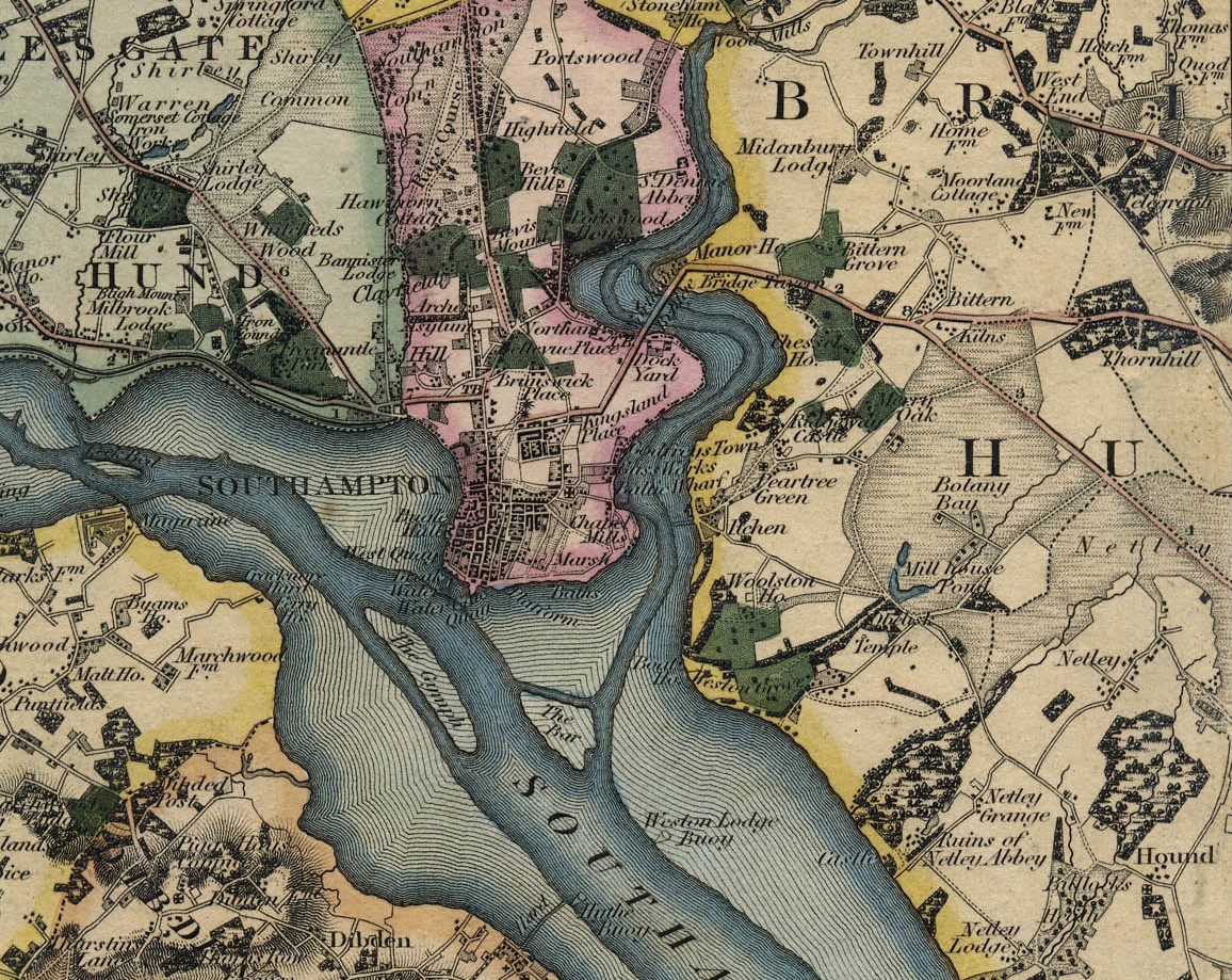
Hound and Netley are shown as well as Bitterne, but Sholing is not on the map yet.
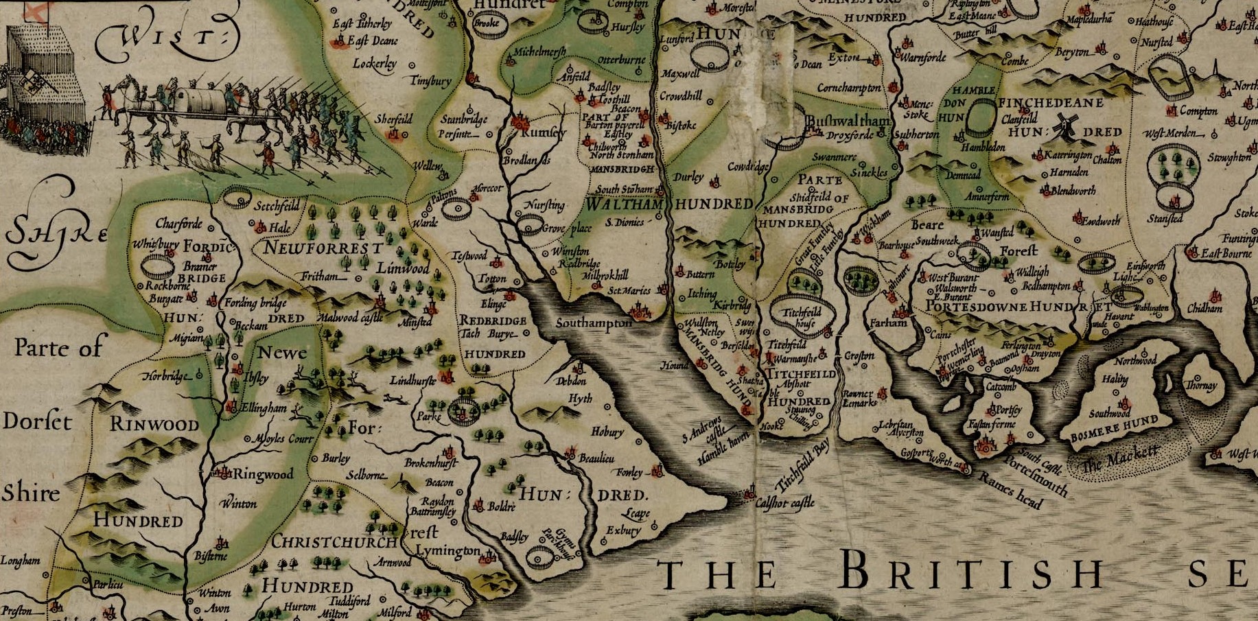 Map, hand coloured copper plate engraving, Hantshire described and divided, Hampshire with part of the Isle of Wight, and a town plan of Winchester, scale about 4 miles to 1 inch, by John Speed, engraved by Jodocus Hondius, about 1611. Published in the Theatre of the Empire of Great Britain, 1611.
The administrative districts called Hundreds are shown on this 1611 map. Hound and Netley are in Mansbridge Hundred, which appears to be in three separate sections, whilst Sholing, which would be between Bitterne and Itchen are in Waltham Hundred. Click on the map to go to the larger source map for greater clarity.
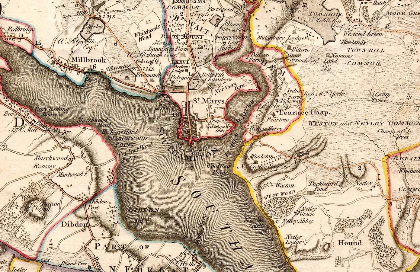 These notes are made from a '1 inch to 1 mile' map of Hampshire surveyed by Thomas Milne, published by William Faden, 1791. The item used is in the Map Collection of Hampshire CC Museums Service, item HMCMS:FA1998.124.
We can rely on Milne's 1791 Map to provide more detail. Hound is shown, as are Netley, Castle, Netley Abbey, Netley Green, Netley Lodge, and Netley. Family seats, or Estates are also shown with the name of the owner. Sydney Farm for instance is annotated The Honourable Mrs Yorke. Sholing, whilst in the vicinity of Sydney Farm, still does not receive a mention.
 These notes are made from a 1 inch to 1 mile map of Hampshire surveyed by C and J Greenwood and N L Kentish, published by Greenwood and Pringle and Co, 1826. The item used is in the Map Collection of Hampshire CC Museums Service, item HMCMS:FA1965.589 - Southampton
Still no Sholing on Greenwood's 1826 version of Hampshire.
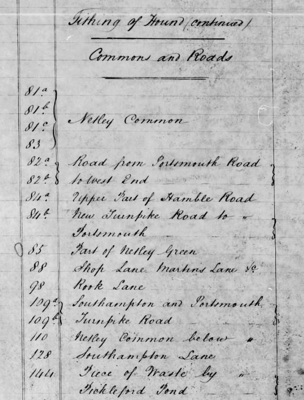
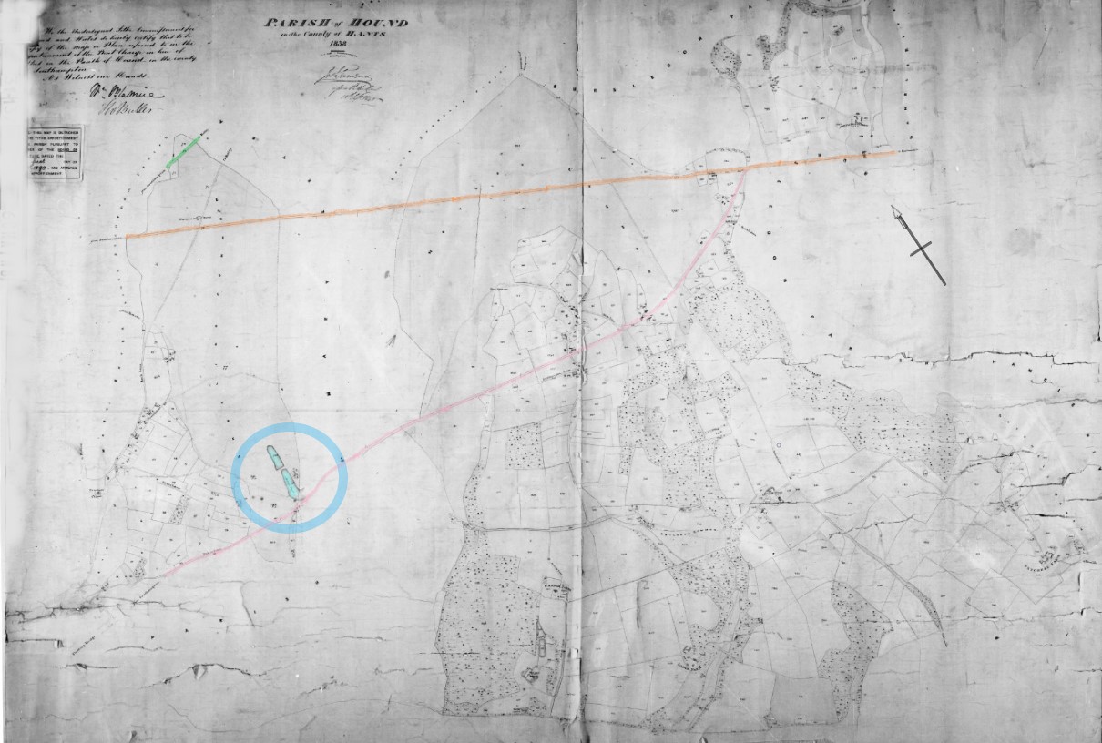 Tithe Map of the Parish of Hound near Southampton
The first recognisable part of the Tithe map of the Parish of Hound, Hampshire was Millers Pond, which fortunately was named on the map and the apportionment, circled in blue. It is a different shape however form the same named pond on the later Ordnance Survey 25" Map. I believe that this can be explained. Hover over the map to zoom in. The brown wash area is the Parish of St Mary's Extra. Millers Pond on the map starts to curve upwards, but it enters another parish and the drawing on the pond is not completed. The additional pond north of Millers pond could have been filled in.
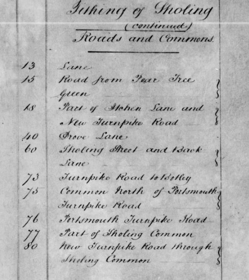 Extract of Parish of Hound Tithe Apportionment with Sholing Roads and Commons
There are a number of roads listed in the Parish of Hound Tithe Apportionment in the Tithing of Sholing, Roads and Commons, in particular;
| Plot | Description | Colour wash |
|---|---|---|
| 18 | Part of Itchen Lane and New Turnpike Road | Pink |
| 73 | Turnpike Road to Botley | Green |
| 76 | Portsmouth Turnpike Road | Brown |
| 80 | New Turnpike Road through Sholing Common | Pink |
| 84b | New Turnpike Road to Portsmouth | Pink |
| 109a & b | Southampton and Portsmouth Turnpike Road | Brown |
| 423 | Turnpike Road Near Bursledon Bridge | Brown |
The colour wash refers to the additional colour lines added to the tithe map to indicate the Turnpike Roads crossing the parish. The light green area on the zoom in map, hover over with a mouse, is Sholing Common. Itchen Lane is shown on the route of the New Turnpike Road. Sholing Lane, towards the top left of the map in red wash. The New Turnpike Road is presumably to serve the Itchen Floating Bridge, also shown on the main map.
South Stoneham Registration District
- Registration County : Hampshire.
- Created : 1.7.1837.
- Abolished : 1.4.1927 (to become part of Eastleigh registration district).
- Sub-districts : Millbrook, St. Mary Extra, South Stoneham.
- GRO volumes : VII (1837-51), 2c (1852-1927).
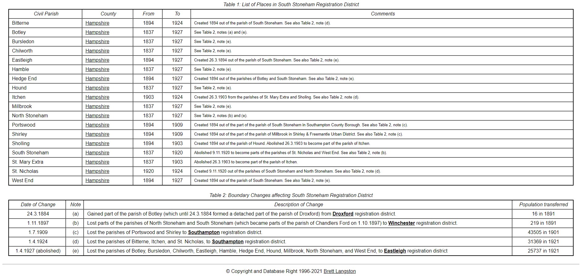
A lot of my close Family History is based around Hampshire, and in particular the South Stoneham Registration District. Records frequently stating South Stoneham, which from the above table by Brett Langston it is evident covers a large area, as well as the village of South Stoneham. Hover over the map of the Parishes of Hampshire to zoom into the parishes around South Stoneham.
Onward to 1840s, and OS Old Series Hampshire 1810 (revised). Southampton has a dock and the railways have arrived. Sholing, circled in red, has arrived on a map.
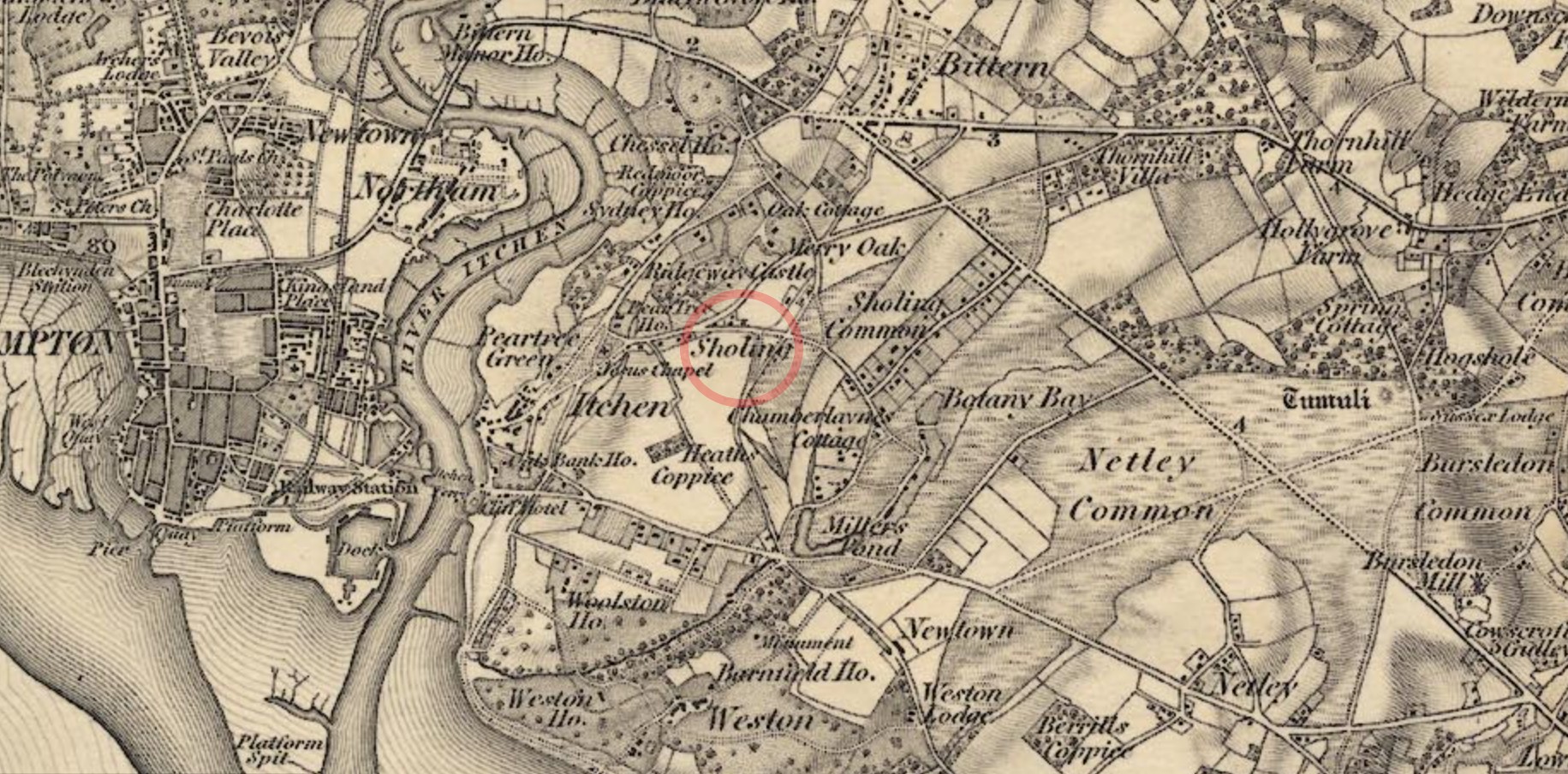 These notes are made from the first edition, Old Series one inch to one mile maps of Hampshire surveyed by the Ordnance Survey, Tower of London, London, published in the 1810s. The maps used are mostly later editions mostly from the 1840s, and are in the Map Collection of Hampshire CC Museums Service
Sydney Farm appears to be Sydney House and Ridgeway, Ridgeway Castle, but no owners shown. Botany Bay also makes a appearance, between Sholing Common and Netley Common.
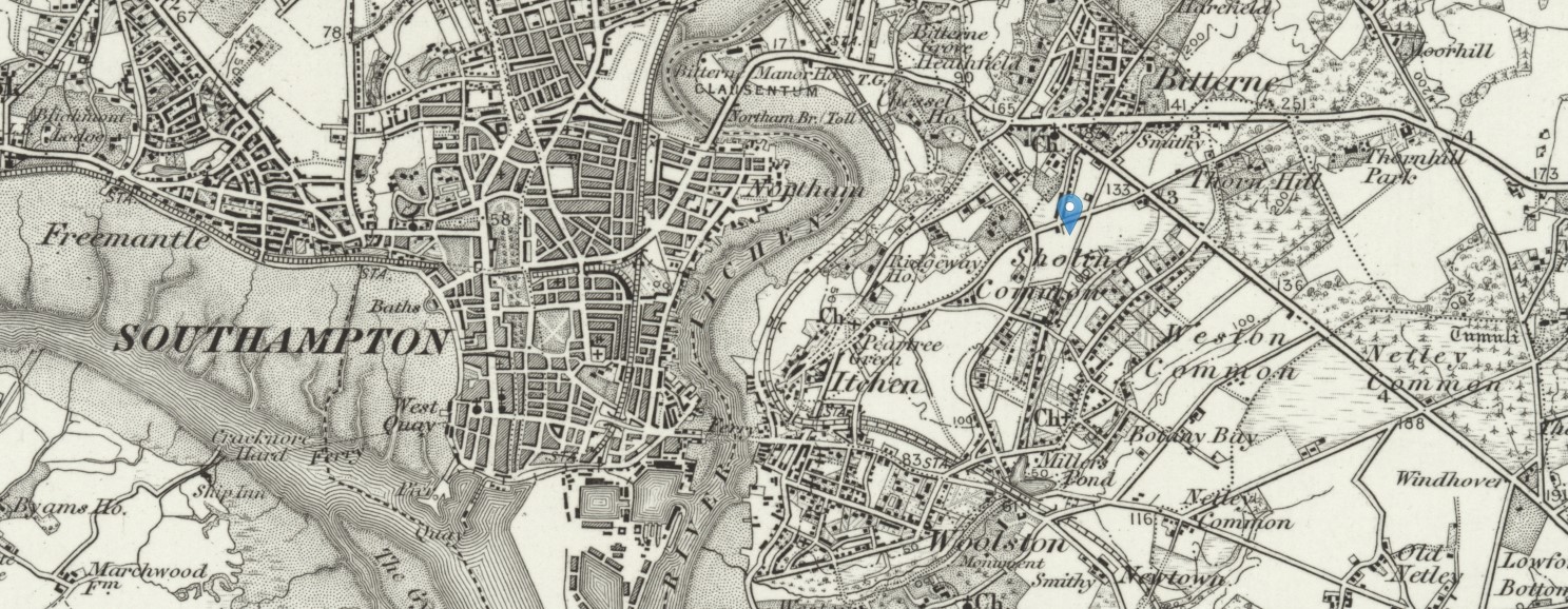 Ordnance Survey Map Southampton (Outline), Sheet 315, Revised: 1893, Published: 1895 - Marker at Sholing
In 1893, it is evident from the one inch map above that Sholing is still predominantly rural and not yet absorbed into a suburb of Southampton. The address would therefore be Sholing, Hampshire, or Sholing, Bitterne, Hampshire, in the registration district of South Stonham.
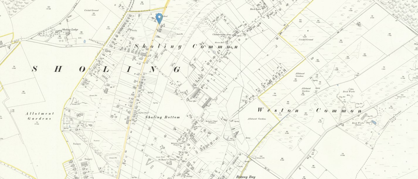 Hampshire and Isle of Wight LXV.12, Revised: 1895, Published: 1897 - Sholing Common
Change to a 25 inch OS Map and there is more detail to look at. The map seems to indicate that Sholing Common and Sholing Bottom are included the general area of Sholing, together with, potentially, at the very bottom of the map, Botany Bay. Click on the map to investigate further. Middle Road has a gravel colour wash.
Wikipedia also has an article about Sholing
In 1920, the village became part of the Borough of Southampton. Its history as a separate entity ended then.
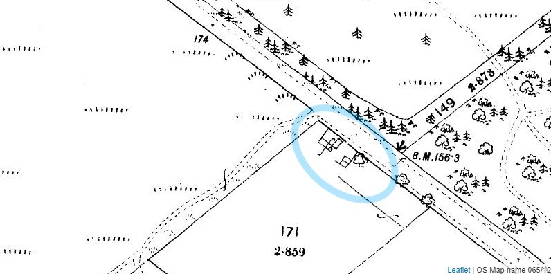
Middle Road Sholing
As stated Middle Road has a gravel colour wash on the last map above.
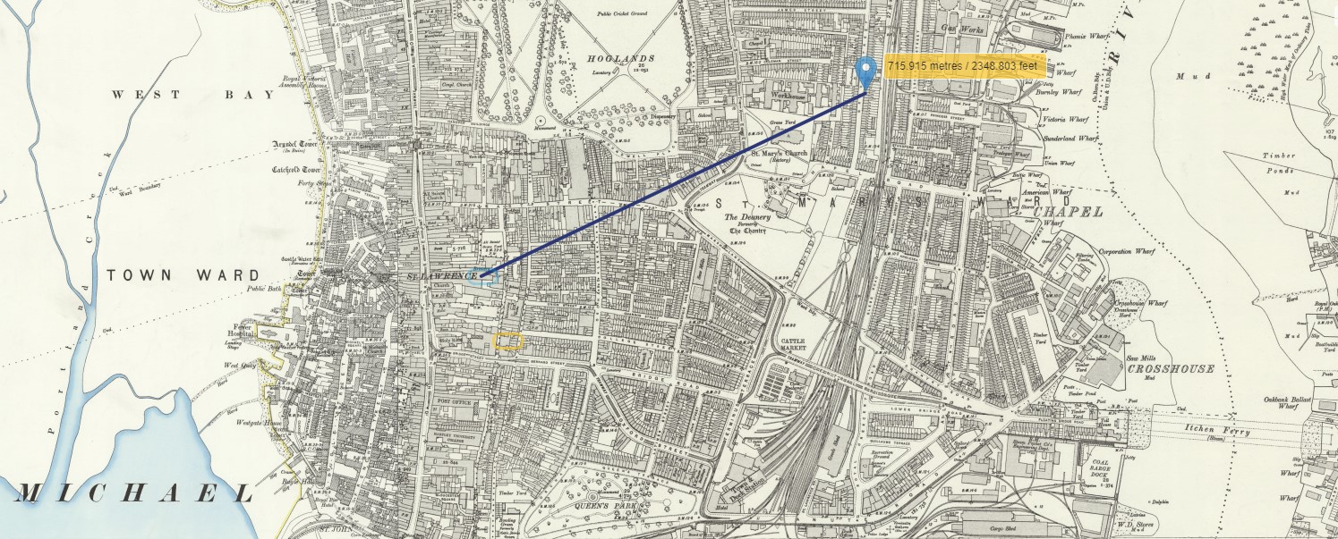
Focusing on the top end of Middle Road where according to Google maps 214 Middle Road is situate, assuming that there has been no renumbering, which we have previously noted, is not uncommon.
 'OS Map name 065/12', in Map of Southampton and its Environs (Southampton, 1867-1887), British History Online http://www.british-history.ac.uk/os-1-to-2500/southampton/065/12 [accessed 19 April 2022].

Using the Georeferenced Mapping of the National Library of Scotland and the Google Map above, the marker on the last map above is the location of 214 Middle Road.
Why is 214 Middle Road significant?
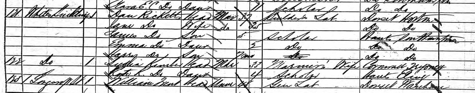
From the Census records of 1881, Dan Ricketts (37), his wife Jane (35), sons and daughter, James (5), Emma (2) and Harry (7 months), were all living at Whites Buildings, near the junction of Bevois Street and Longcroft Street. Adjacent to Tripley Cottages.
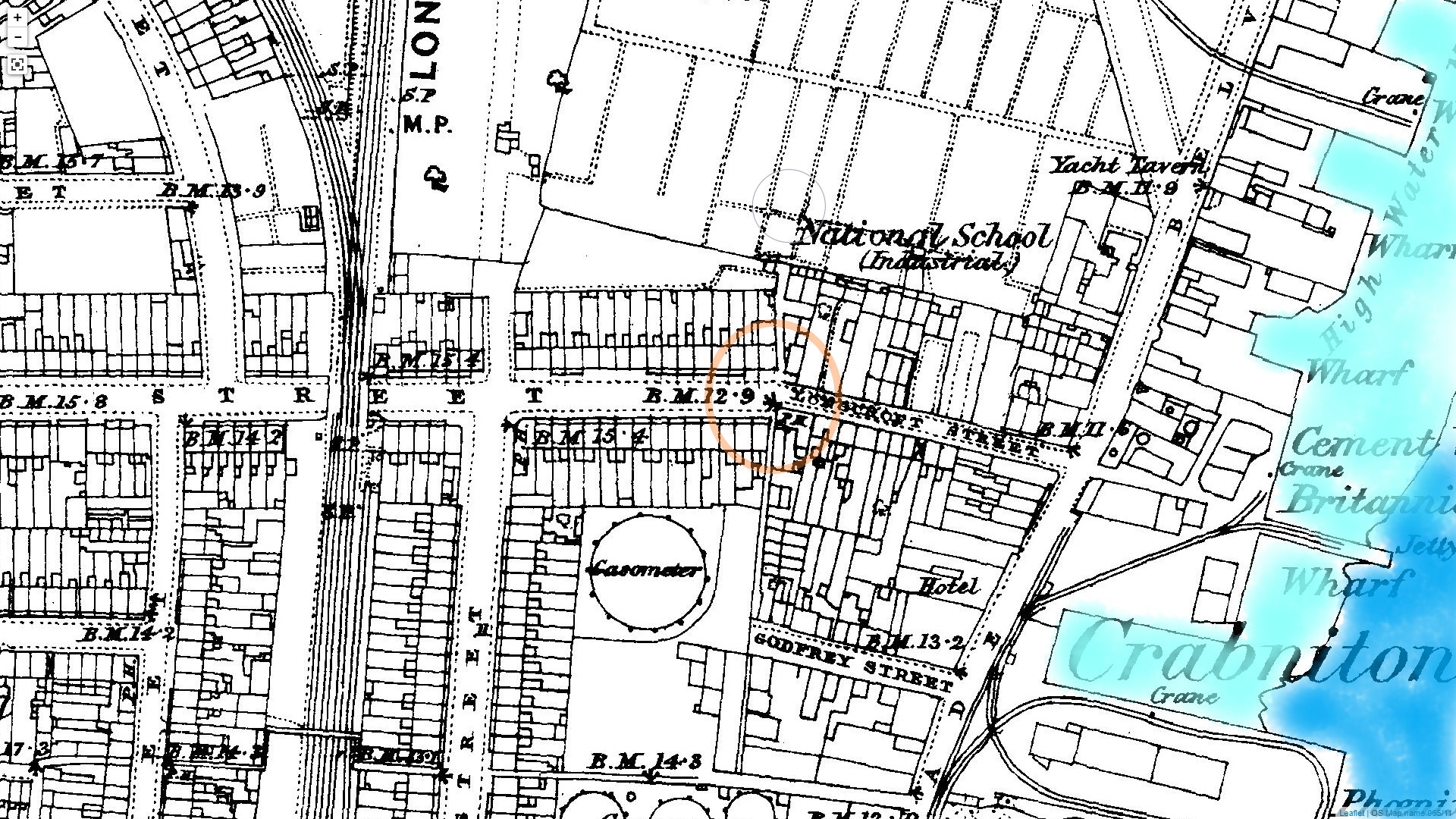 Whites Buildings circled. 'OS Map name 065/11', in Map of Southampton and its Environs (Southampton, 1867-1887), British History Online http://www.british-history.ac.uk/os-1-to-2500/southampton/065/11 [accessed 19 April 2022]. Colour wash added.
The junction of Bevois Street and Longcroft Street circled in orange, hence Dan Ricketts home, with his family, of Whites Buildings. Dan is Percy's grandfather. The River Itchen is washed in blue, so they are still town side of the river, in Southampton between the Test and the Itchen.
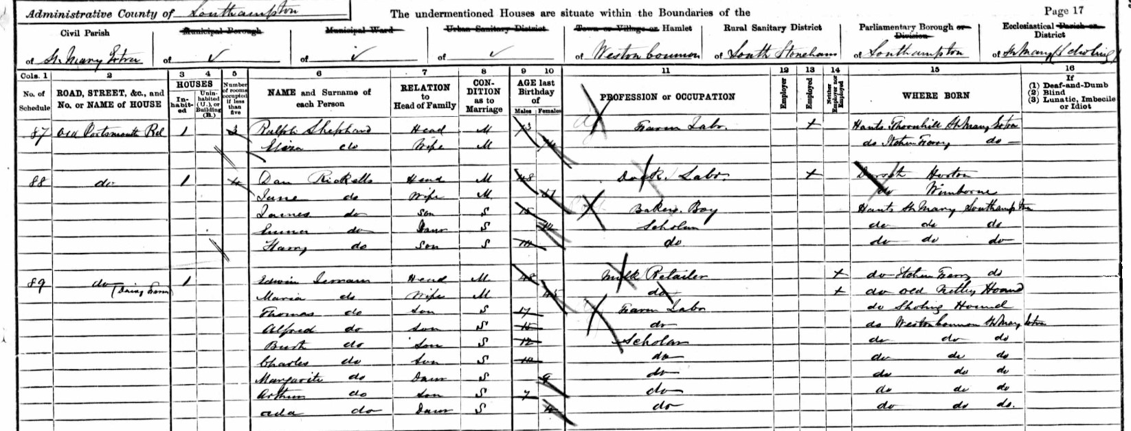
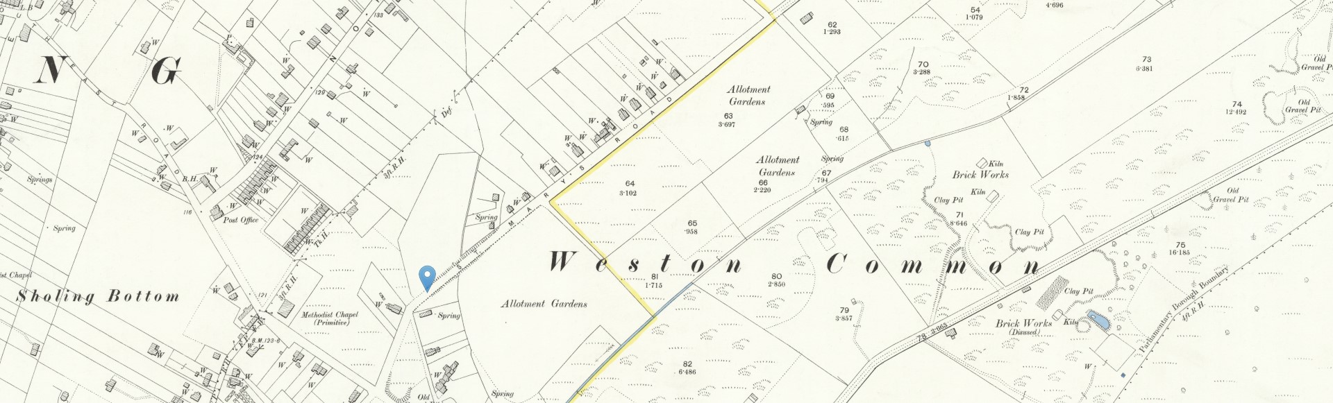
Ten years later the family had moved across the River Itchen, to Old Portsmouth Road, Weston Common, St Mary Extra, Hampshire, England, near the Dairy Farm. James, now 15, Percy's Dad, was a Bakers Boy. Precy's grandfather, Dan Ricketts was a Dock Labourer, but had moved further away from the docks
I have yet to find Old Portsmouth Road, but it was preceded by St Mary's Road in the Census.
The Roman Road from Chichester to Bitterne crossed the River Hamble at Curbridge and ran near to present day Manor Farm. It was here that Botley’s first settlement began and, later in Saxon times, a church was built here.
Rising sea levels in the first millennium forced travellers to ford the river further upstream and Botley village developed in the area we know today.
Crossing the river at this point was dependent on water levels and travellers could be stranded in Botley to await the low tide. This was probably the reason for 14 pubs and ale houses said to have existed in Botley in the eighteenth century.
For centuries, the only crossings of the river Itchen in this area were at Mansbridge, some distance upstream from Southampton, and at Itchen Ferry village. The Northam Bridge Company was formed in 1796. They built a toll bridge at Northam which was opened in September 1799 and new roads connecting the bridge to Southampton and Botley, Hampshire. The town was further connected to Portsmouth via another toll bridge built at Bursledon and another road which linked Bursledon bridge to the new Northam to Botley road at Bitterne.
Antonine Itinerary VII documents the Roman settlement of Clausentum in Roman Britain as being 20 miles (32 km) west of Noviomagus Reginorum (Chichester) and 10 miles (16 km) from Venta Belgarum (Winchester).
Archaeological finds at what is believed to be Clausentum show the site to be an important trading port with some significant buildings. Traces of a Roman Road on a line running from Bitterne Manor to Wickham have also been found.
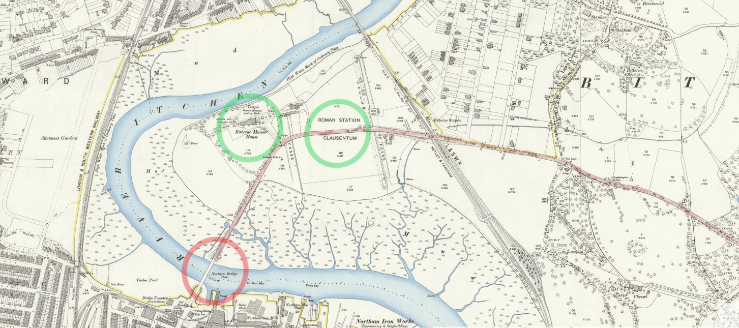
Northam Bridge is circled in red, and Bitterne Manor and Clausentum in green. The brown road could therefore be the Old Portsmouth Road, part of the Roman Road.
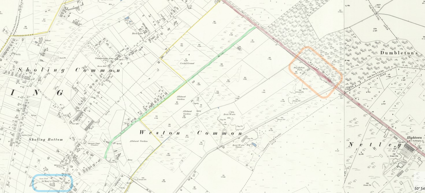
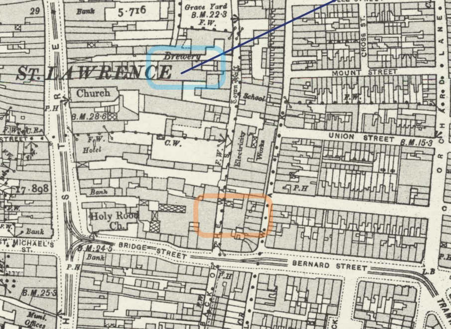
The road in brown continues, with Spring Hill and Step Bottom Farm boxed in orange. St Mary's Road colour washed in green, with St Mary's Church at the bottom boxed in blue. St Mary's Road is now Kathleen Road, using the Georeferenced Mapping of the National Library of Scotland. The brown road is Bursledon Road, A3024, previously a Turnpike Road.
The brown road continues on to Bursledon toll bridge and Park Gate, and thence to Portsmouth.
Going back to the 1891 Census papers, below is, Richard Davis, the Enumerator's Route.
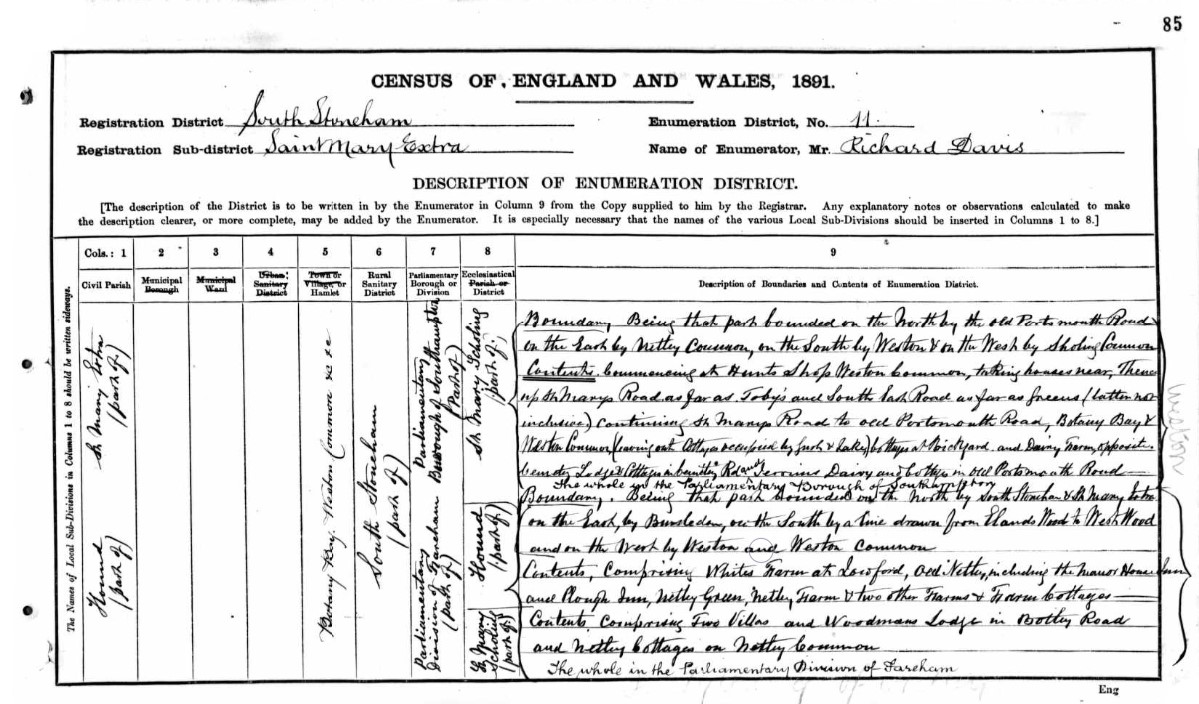
Scroll over the image to zoom in.
Transcription;
Boundary; Being that part bounded on the North by the old Portsmouth Road, on the East Netley Common, on the South by Weston, & on the West by Sholing Common.
Contents; Commencing at Hunts Shop Weston Common, taking houses near, thence up St Mary's Road as far as Joby's and South East Road as far as Greens / latter not inclusive) Continuing St Mary's Road to old Portsmouth Road, Botany Bay & Weston Common(leaving out Cottages occupied by Gush & Lake) Cottages at Brickyard and Dairy Farm opposite Cemetery Lodge and Cottages in Cemetery Rd and Jerrims Dairy and the Cottages in old Portsmouth Road. The whole in the Parliamentary Brought of Southampton.
There may be a significance in that the old in old Portsmouth Road is lower case.
Itchen ferrymen (and women) rowed and sailed their passengers across the turbulent, tempestuous River Itchen until the Floating Bridge began service in 1836. (interesting read)
Just 55 years before the 1891 Census. The Portsmouth Road, or the road to Portsmouth changed to a more Southerly route via the Floating Bridge.
Old Portsmouth Road could be more descriptive that the current (1891) name of the road.
In conclusion, I am reasonably convinced by the foregoing that Dan Ricketts and his family lived in the vicinity of Spring Hill in 1891.
Perhaps these buildings, on 'Map of Southampton and its Environs'. Originally published by Ordnance Survey, Southampton, 1867-1887, but not shown on Ordnance Survey Hampshire and Isle of Wight LXV.12, Revised: 1895, Published: 1897, The 1891 Census was between the dates of the two maps.
 BHO OS Map near Spring Hill, top of St Mary's Road. 'OS Map name 065/12', in Map of Southampton and its Environs (Southampton, 1867-1887), British History Online http://www.british-history.ac.uk/os-1-to-2500/southampton/065/12 [accessed 21 April 2022].
Again, why is 214 Middle Road significant?
Also, why are the above places of any interest as Percy is not born until 1904, after all of the Census information so far? It is to get a sense of the location and movement of his immediate ancestors. A feel for the environment into which he was born.
Or next Census, 1901, was not regarding Dan Ricketts as head of the family, with James as the son, but is with James, the father of Percy, as the head of the family, located in Middle Street.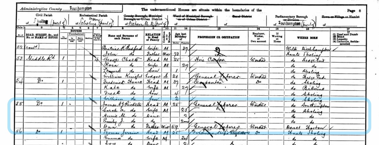
Dan is still listed, not as Head but as father. The address is Middle Road Sholing, as part of Itchen Urban. District. Both James and Dan are described as General labourers. Dan is now a widow and James is married to Sarah A Ricketts.
James and Sarah have two daughters, Annie M (2) and Emily J, (2 months).
There is no number indicated as to the position on Middle Road. However, the Census for the area starts at the Railway Inn opposite Millers Pond, which presumably is the P.H. (Public House) shown on the OS map of the area. This puts the start of the Census record and the southern end of Middle Road. The next name place along Middle Road on both the OS Map and the Census is the Baptist Chapel. Past the Ricketts 1901 home is the Boys School, on the West side. The Enumerator then heads southward on the West side of Middle Road. So there are 117 properties on Middle Road starting with Railway Inn and ending at Shrub Cottage. With the Boys School being the first annotated as west side being property 76, it would appear that the East side of Middle Road consists of 75 properties. The Baptist Chapel is property 17. With the Ricketts living at property 55, they are on the East side of Middle Road is 28 up from the Chapel and 20 from the end using the schedule numbers as a guide. Now, counting on the OS Map. Now that is encouraging, the chapel is property 17 on the map, although if the properties off the road but accessed from it are included, there is an additional 4 properties. Counting from the map is not a precise science as the Census and the map are not of the same time, and a building shown on the map is not necessarily residential and included in the Census. On the map 24/25 properties form the Chapel gets you to South East Road, and probably Laurel Cottage. From the other end of Middle Road on the map there are 8 properties adjacent Middle Road near the Brick Works, 2 or 3 more on the approach to the brickworks, some with glass houses, and 6 down a side track. There is also a cluster of eight properties opposite the boys school.
In all probability the Ricketts home would have been in that latter cluster, in the vicinity of the boys school, which according to Google Maps, is the approximate location of the current 214 Middle Road. Not necessaserily the same home but not far off.
Below is the 2002 Google Street Map image of 214 Middle Road.
There are further details of the property on the Rightmove website, where there are floor plans, information regarding sales, but not a date of construction.
The 1911 Census and Percy Ricketts makes an appearance. Still in Middle Road.

The ten years between Census has brought more children to the family.
{slider title="Home B"}
Your text...
{slider title="89 Grove Street"}
89 Grove Street, Southampton
Where is Grove Street?
It is in the Chapel area or St. Mary's area of what was the town of Southampton, Hampshire, England.
The Sotonpedia entry is;
Grove Street and Grove Court
Grove Street
Runs south/north from Chapel Road to Bevois Street in St Mary’s. It is part of the traditional road from Hamwic to Northam, though its predecessor, Golden Grove, followed a slightly different course.
Grove Street Cottages
In the 19th century these cottages were situated on the west side of Grove Street, south of Bevois Street.
Grove Court
A 19th century Court in Grove Street, on the west side to the north of James Street.
Hamwic and Hamtun
The Saxon settlement at Southampton was known either as Hamwic or Hamtun (variant spellings include Hamwih, Hamwich and Hamton, Hampton). The former signifies a trading centre, the latter applying to the settlement in its administrative function.
The two names co-existed throughout the Anglo-Saxon period. Hamwic survived as a name until the 11th century. Hamtun survived and evolved into Southampton. The first reference to Southampton was in the Anglo-Saxon Chronicle of 980 but the name did not become common until the 12th century. Hamtun was an alternative name for the town until the 17th century.
Grove Street can be found on an 1870 OS Map held and hosted by Southampton City Council .
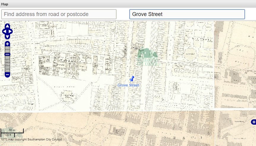
Click the map to go to the source.

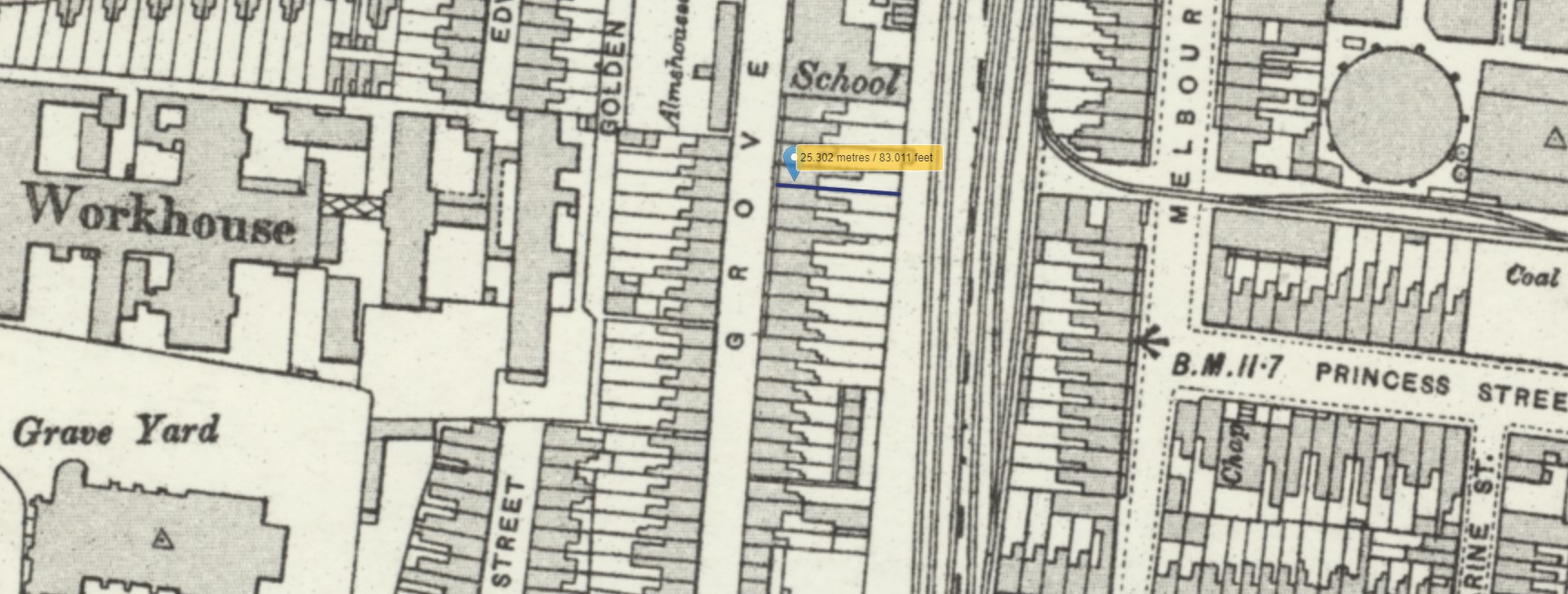
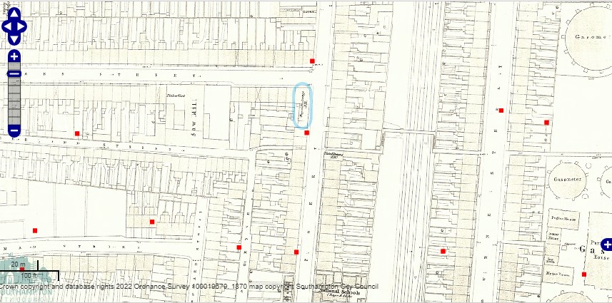
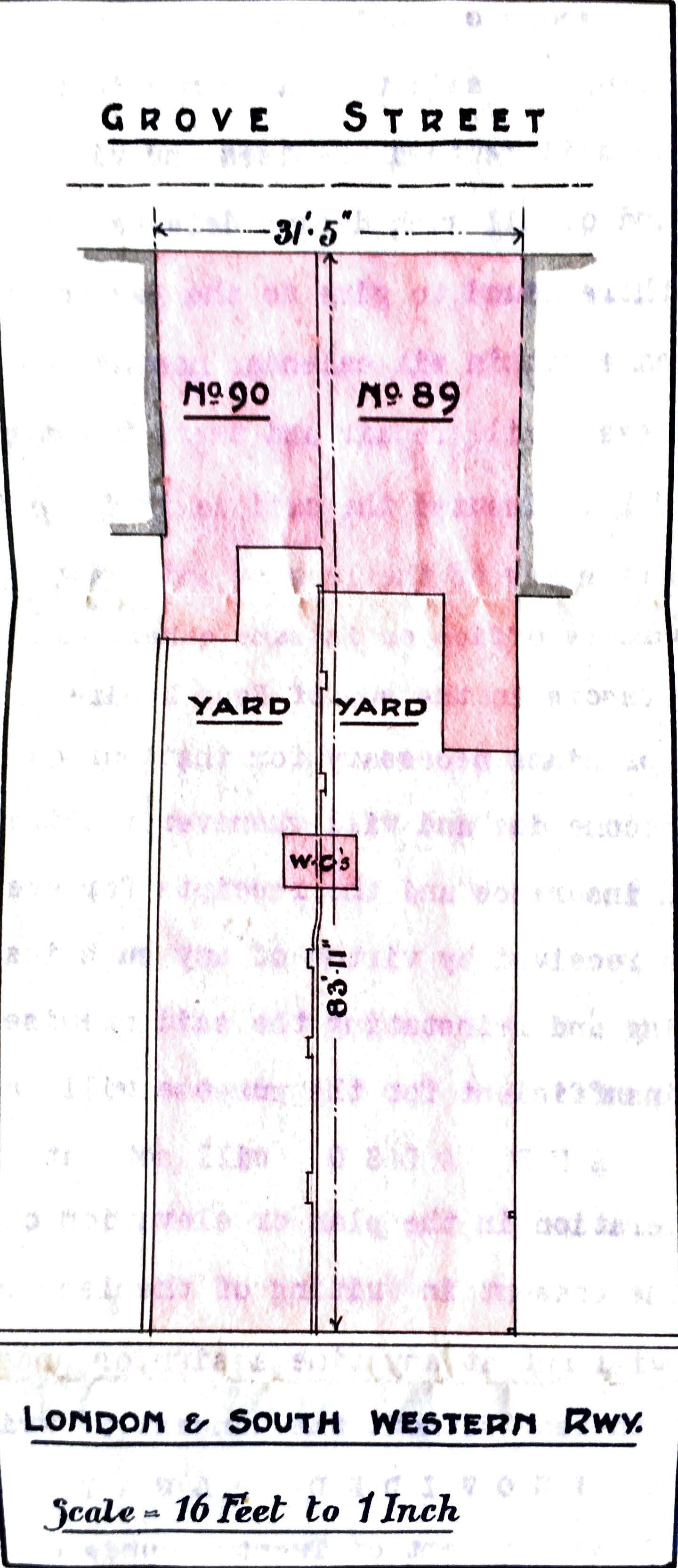
Another Ordnance Survey Map, held and hosted by the National Library of Scotland. The marker may be the location of 89 and 90 Grove Street, and the plot measurement is about the same as on the lease. I recall being told that 89 Grove Street backed on to the railway. The pattern of the houses footprint suggest that it maybe this pair of houses.
On the map, nearly opposite the marker, you can see the Almshouses. Sotonopedia has an article containing information about them, of which there is an extract below, together with one of the two photos.
Grove Street Almshouses
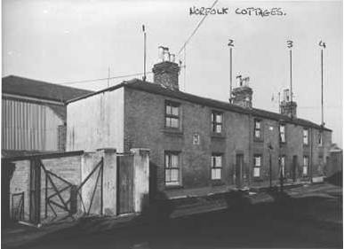
In 1830 the St Mary’s site was acquired by the Poor Law Guardians for the new workhouse. In return the Guardians supplied a site in Grove Street on which seven new almshouses were built in 1831 (image 1 below). On the wall between numbers 1 and 2 was set a stone tablet which had originally been placed on the front of Butler’s Almshouses in 1565 (image 2 below). The stone tablet had a carving of three roses, the date 1565 and initials R.B. (Richard Butler). These almshouses, later renamed Norfolk Cottages, survived until c.1960.
WW2 Bomb damage
Extract of list of 'Photographs of War Damaged Properties' from The National Archives
60 a-c 13, 14 & 15 Grove Street, 1947.
61 a-b 17 Grove Street, (front and rear), 1947.
62 a-c 20-25 Grove Street (front and rear), 1948.
63 a-b 40½ Grove Street, 1948.
64 a-c 54, 55 & 56 Grove Street, 1948.
65 a-d 82-87 Grove Street (front and rear), 1947.
66 a-b "Royal Exchange" P.H. Grove Street, 1948.
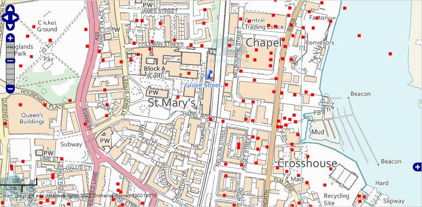
The above map is current with superimposed WW2 recorded bomb sites. The area was heavily bombed during WW2. There is still a Grove Street according to this map, but not as long as it used to be. The whole are has been redeveloped. I recall my Mum telling me about the crater at the end of the road, by the level crossing. I suspect that was the one shown between the A and D of the label Chapel Road on the map. Walking with her Mum, past the bomb crater in wellies, then changing into school shoes, for the rest of the short walk to school.
Back to the 1870 map of Grove Street, but with the WW2 bomb sites layer added. Three in this section of Grove Street, all the other side of the road from no. 89. The Royal Exchange Public House, mentioned in the list of photographs of bomb damage properties, is circled in blue. The list appears to have more instances than the map.
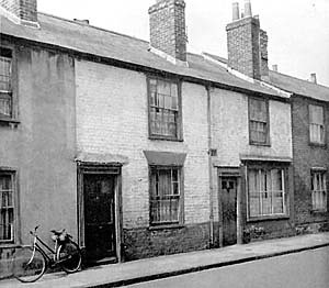
A photo posted in Flickr by Robert Fish reproduced here with his kind permission.
Robert's comment plus one other
Its actually in Grove Street, just off Chapel Road, looking at OS maps these were pulled down between 1968 and 1971. In the last few months there has been an Archaeological dig within Southampton City College (in the area of these houses) and they have turned up a number of Middle Saxon Houses (3 at the last count) which have not been damaged by ploughing. The site lies near the southern edge of the Middle Saxon town of Hamwic. Photo's from the dig, and of the very deep brick build drainage pipes will be posted soon in my photo stream.
Pete Lamb
The houses were demolished too make way for the Itchen Bridge (ha ha). The final design of the bridge went no-where near here.
A lot of TITANIC crew lived in these closely knit roads.
Table constructed by reference to Encyclopedia Titanica
| Name | Age | Address | From ship | Job |
|---|---|---|---|---|
| George Phillips | 27 | 5 Grove Street | Olympic | Greaser |
| W. Light | 47 | 25 Grove Street | Olympic | Fireman |
| Frank Terrell | 26 | 5 Grove Street | Oceanic | 2nd Class Steward |
| A. Manly | 23 | 5 Grove Street | Oceanic | 3rd Class Steward |
| Albert Haines | 30 | 53 or 62 Grove Street | Olympic | Boatswain Mate |
| William Henry Dyer | 33 | 68 Grove Street (1911 Census) | Olympic | 1st Class Steward |
| Walter Hurst | 27 | 13 Chapel Road | Olympic | Fireman |
| William Mintram | 46 | 15 Chapel Road | Oceanic | Fireman |
The table is not necessarily a complete list of those with Grove Street connections. Some of the people perished in the tragedy, and some survived, but one missed the sailing, having previously signed on to the crew.
I have added Walter Hurst and William Mintram to the table as Chapel Road is at the end of Grove Street, but more importantly, because they are both in my Family Tree and there is an article about them and a murder.
Apparently about 500 of the crew of the Titanic were Sotonians and 1/3 of all the passengers and crew who were lost on that fateful day of 15 April 1912 were from Southampton.
Lease
Alfred James Frampton was born about 1841 in Southampton, Hampshire, England to parents George and Amelia.
Our story does not start there however.
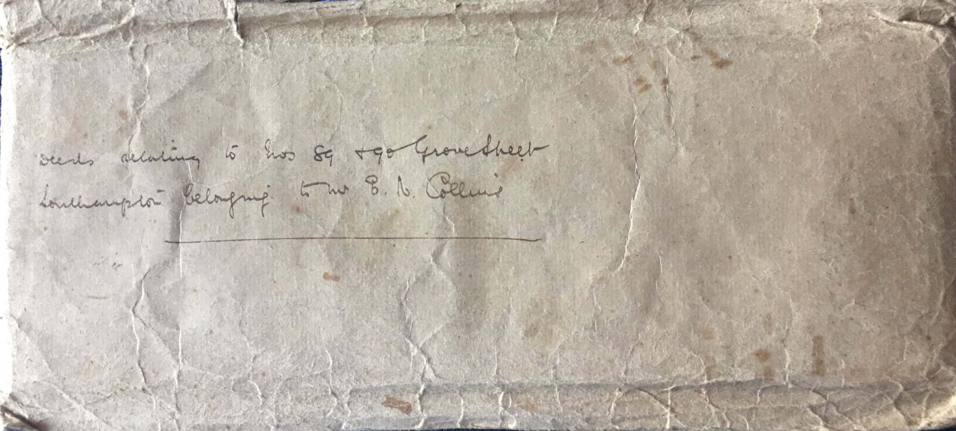
Looking through some old documents at home I found a deeds envelope with 'Deeds relating to Nos 89 & 90 Grove Street Southampton belonging to Mr E N Collins'. What a find, as you can see below.
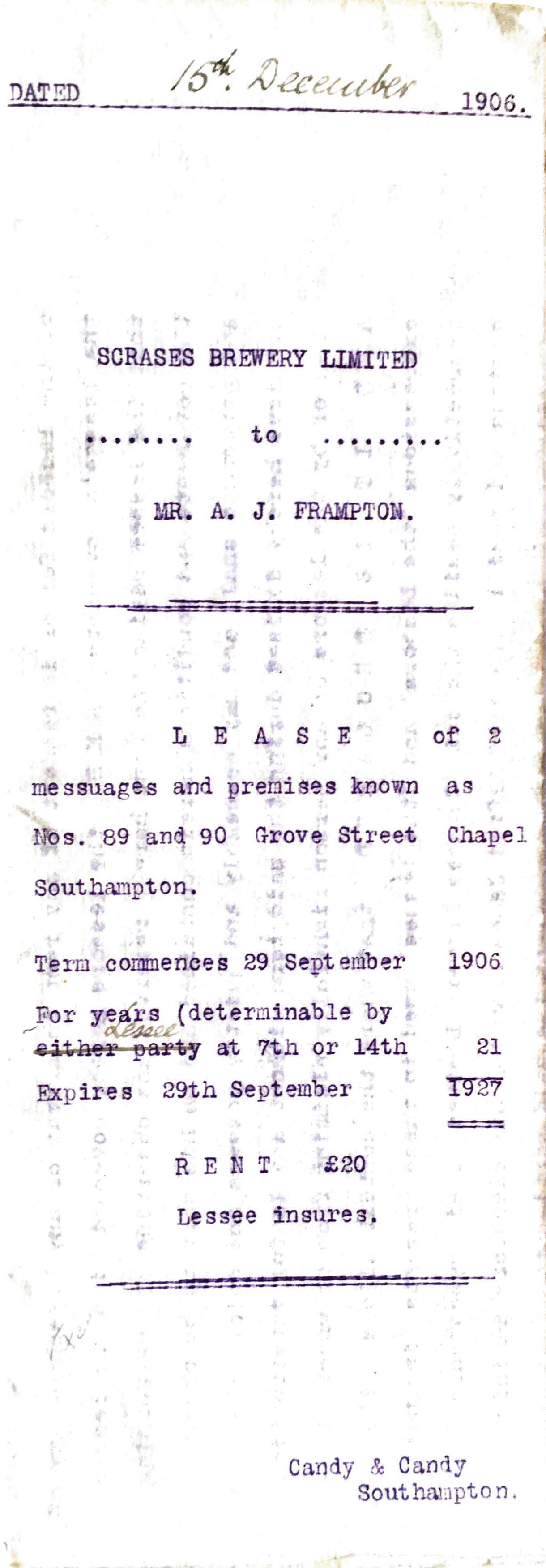
Lease of 2 messuages and premises known as Nos. 89 and 90 Grove Street Chapel Southampton.
![]() Lease 89-90 Grove Street 1906524.34 KB17/03/2022, 18:32
Lease 89-90 Grove Street 1906524.34 KB17/03/2022, 18:32
Click the link to read the full lease.
The next document is the consent given by the Lessor, Scrase's Brewery Limited to the Executors of the Will of Mr. Alfred James Frampton, Messrs, Frank Kimber and George Willis.
![]() Consent 89 Grove Street 1915 Typewritten376.54 KB18/03/2022, 18:42
Consent 89 Grove Street 1915 Typewritten376.54 KB18/03/2022, 18:42
Below is the resultant Assignment to Edward Nash Collins, of 39 Grove Street Southampton
![]() Indenture 89 Grove Street 1915 Handwritten684.29 KB18/03/2022, 17:46
Indenture 89 Grove Street 1915 Handwritten684.29 KB18/03/2022, 17:46
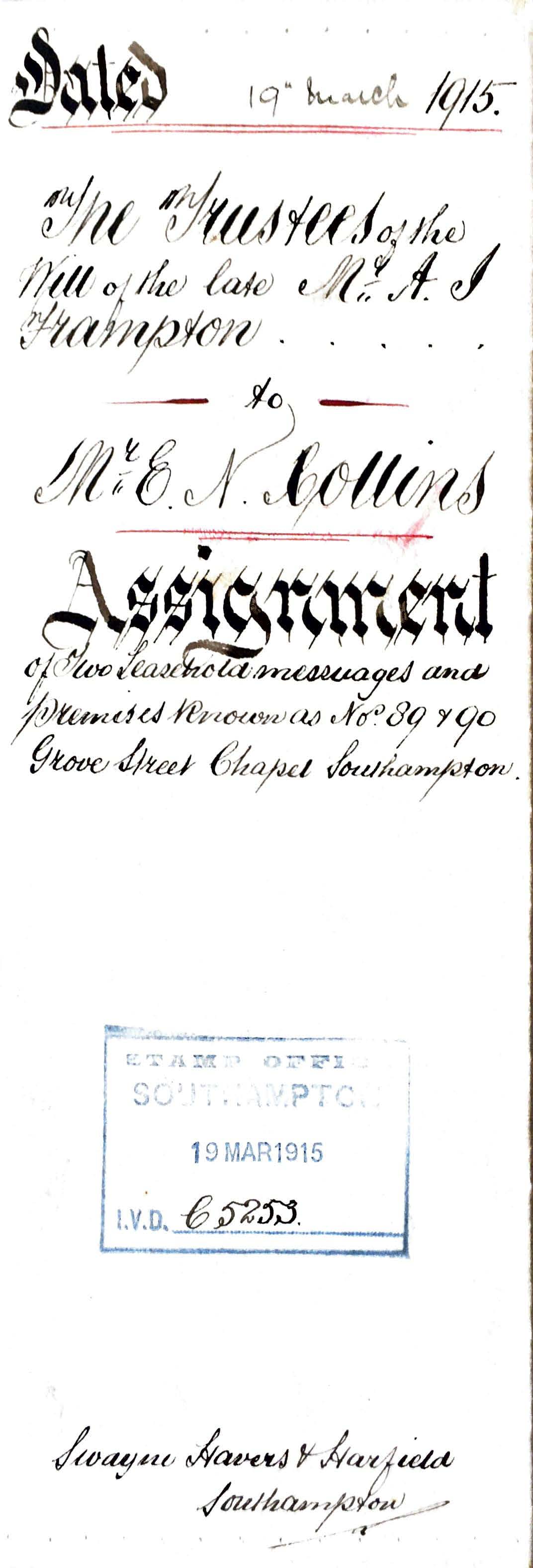
Just admire the penmanship. The scan does not do it full justice.
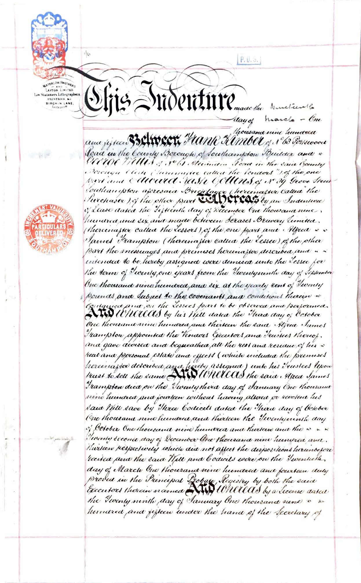
To read the full document click the link to the pdf file above.
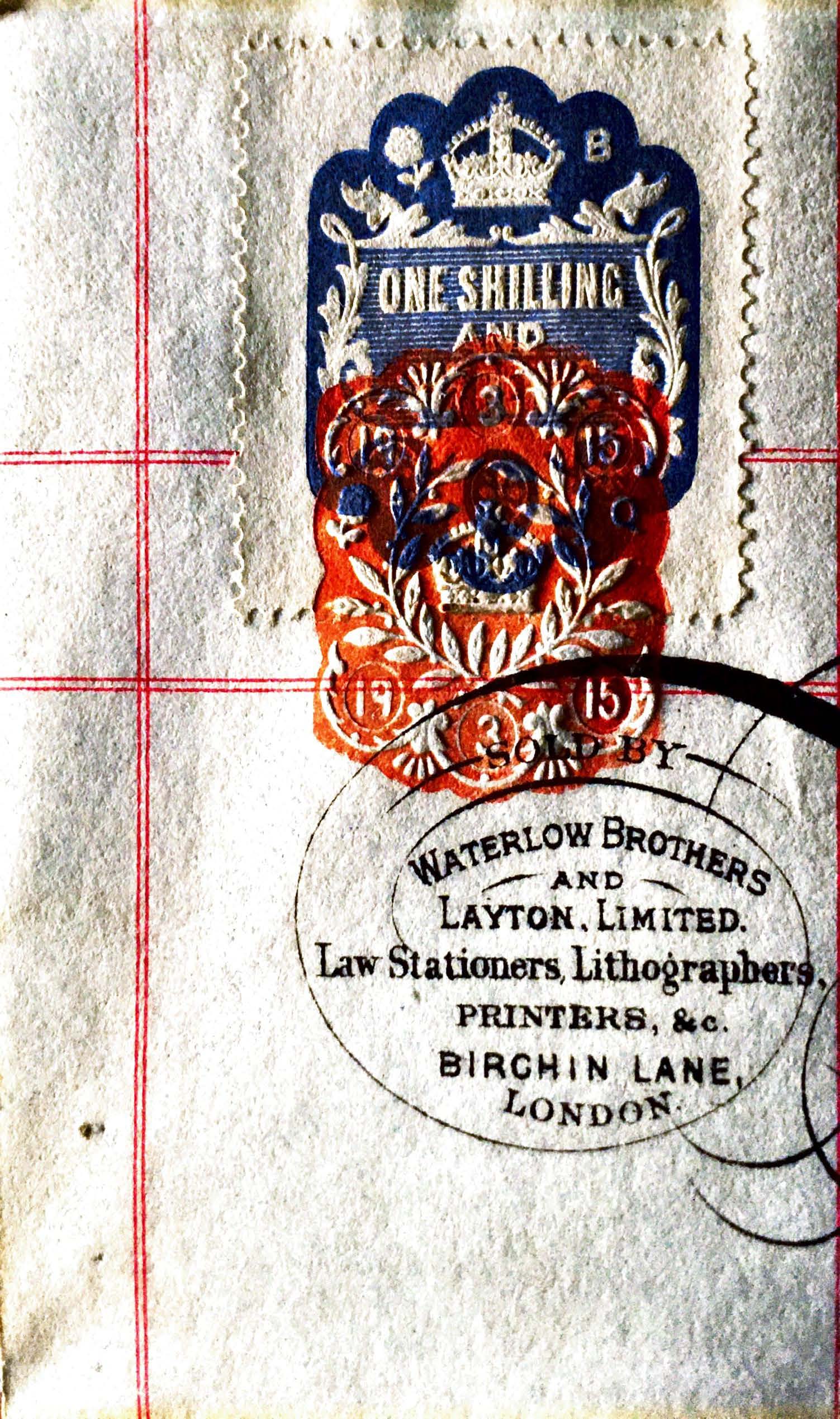
Two more things before we leave this document, the first, a better image of the stamp with a value of one shilling and six pence, and the embossed date stamp indicating March 1915. Stamp duty at one shilling and six pence, which is only 71/2p when converted, plus inflation.
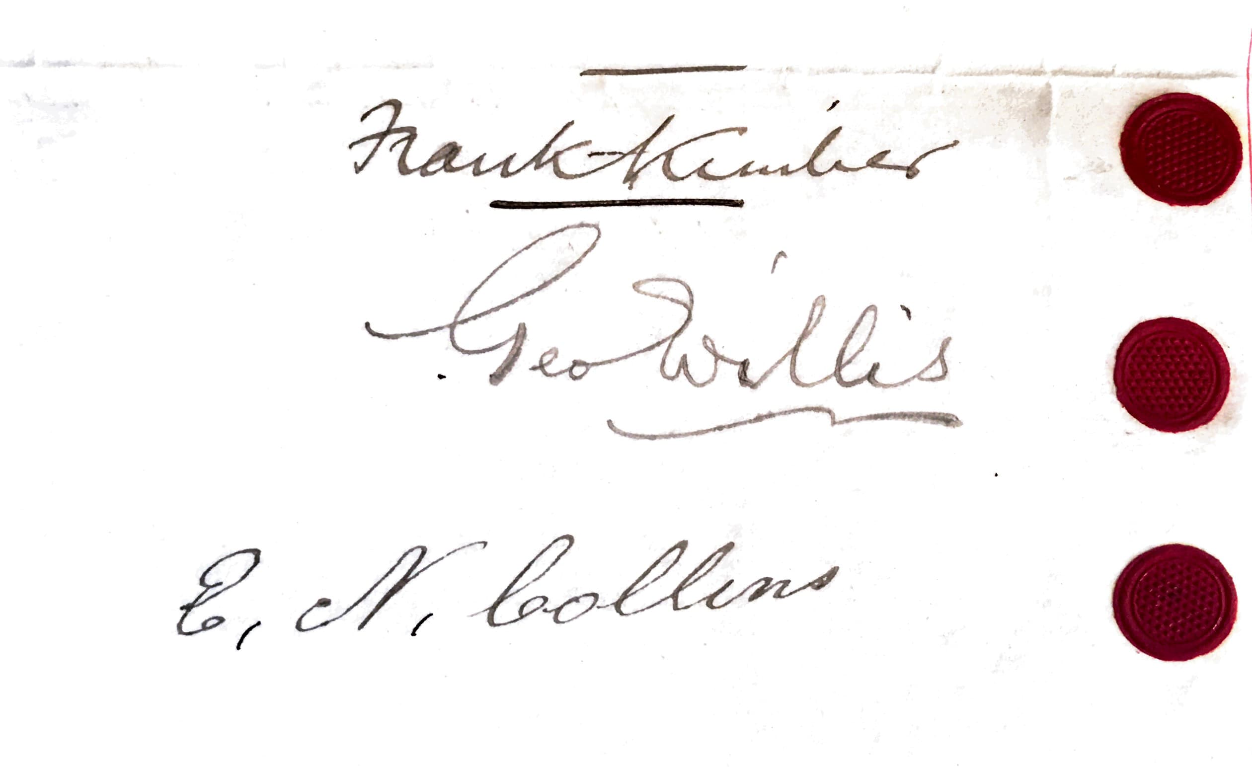
Secondly, a close up of the signatures of the parties, including of course Edward Nash Collins, of No 39 Grove Street Southampton, a bricklayer.
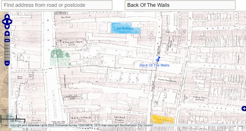
Scrase's Brewery
This brewery, also known as the Star Brewery, formerly stood on the west side of Back-of-the-Walls at the east end of the Star Hotel yard. The business was started by Alderman Scrace in the mid 19th century. In 1890 the business was extended through purchase of the Wheatsheaf Brewery at the rear of the Wheatsheaf Hotel in Bridge Street. The brewery was taken over by Strong’s of Romsey in the 1920s.
Scrase's Brewery Ltd, Star Brewery, Upper Back of Walls, 29 High Street, Southampton, Hampshire.
Founded 1829.
Registered November 1889 to acquire Henry Scrase.
Acquired by Strong & Co Ltd. 1927 with over 97 houses and brewing ceased 1947.
Maltings were at the rear.
List of Scrase's owned pubs in Grove Street.
Apollo Inn, Grove Street, Southampton (ex- Henry Welsh, Wheatsheaf Brewery, Southampton)
Southampton Transport Workers’ Social Club, Grove Street, Southampton.
Star Inn, Grove Street, Southampton (closed 1905)
Rink Tavern, formerly Cabman’s Arms, Grove Street, Southampton was purchased in 1892 from Henry John Panton & Co, Wareham, Dorset.
The site of Scrase's Star Brewery, washed in blue, together with Wheatsheaf Brewery washed in orange.
Below, approximately 800 yards between Star Brewery and 89 Grove Street
Zoomed in on the two breweries, the Star and the Wheatsheaf.
Apollo
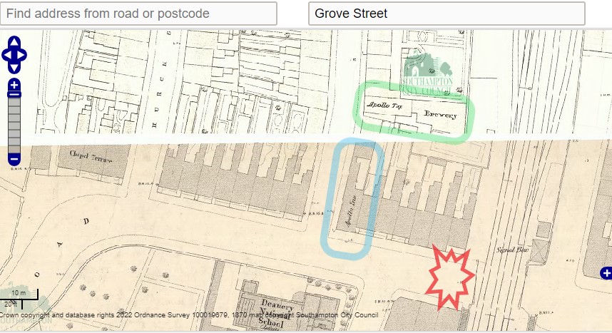
At the Chapel Road end of Grove Street there is an Apollo Inn, on 13 Chapel Road, circled in blue. Apollo Tap and Brewery circled in green. An early thought was that the Brewery was the one referred to in the original lease of 1906, but that is not the case.
Note the Deanery National School at the bottom of the map, the level crossing, and by reference to the WW2 Bomb Map, the crater between the two. The crater could have been closer to the road junction or Apollo Inn.
Census
Edward Collins was resident at 89 Grove Street for the 1911 Census. This was to be expected as he was referred to as 'the present tenants of the said property under the Lease. hereinafter mentioned to Mr. Edward Nash Collins of No. · 89, Grove Street, Saint Marys, Southampton of the hereditaments and premises comprised in an Indenture of Lease dated the 15th. day of December One thousand nine hundred and six and made between Scrase's Brewery Limited of the one part and the said Alfred James Frampton' within the consent document above.
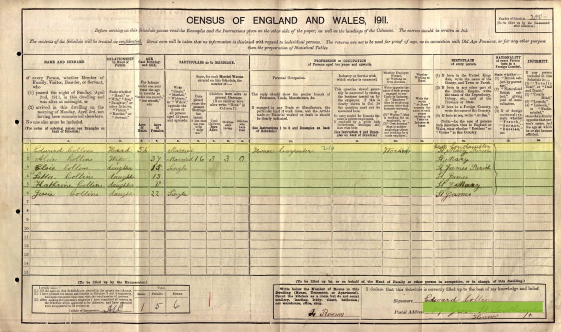
Edward Collins is living at 89 Grove Street with his family
| Name and Surname | Relation to Head | Condition | Age last birthday | Estimated Birth Year | Gender | Years married | Children born | Children still alive | Children who have died | Occupation | Employer / worker | Working at home | Where Born |
| Edward Collins | Head | Widow | 54 | 1857 | Male | House Carpenter | Worker | St Mary's, Hampshire, England | |||||
| Alice Collins |
Wife
|
Single | 37 | 1874 | Female | 16 | 3 | 3 | 0 | St Mary's, Hampshire, England | |||
| Elsie Collins |
Daughter
|
Single | 15 | 1896 | Female | St James | |||||||
| Letitia Collins |
Daughter
|
Single | 13 | 1898 | Female | St James | |||||||
| Kathrine Collins | Daughter | Single | 8 | 1903 | Female | St Mary's | |||||||
| Jessie Collins |
Daughter
|
Single | 22 | 1889 | Female | St James |
Jessie Collins was a daughter to Edward by a previous marriage, and therefore not counted in Alice's children data.
The 1901 Census, Parish of St Mary's, District 35
Does this change things? Zoom in for a closer look.
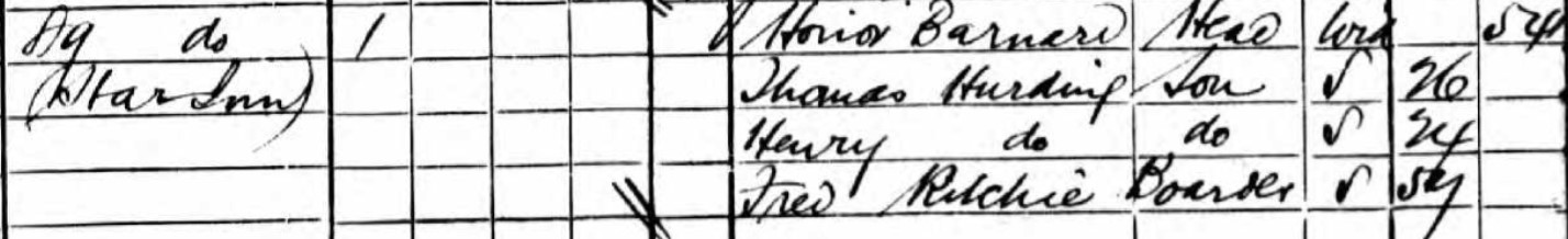
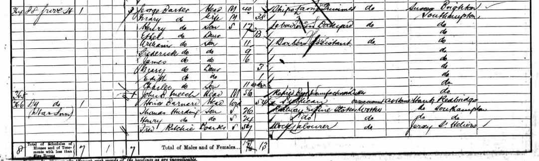
89 Grove Street is the Star Inn in 1901.
According to the List of Scrase's owned pubs in Grove Street above, the Star in was closed in 1905. This makes sense with the lease of Nos. 89 and 90 Grove Street Chapel Southampton to Alfred James Frampton in 1906.
| Name and Surname | Relation to Head | Condition | Age last birthday | Estimated Birth Year | Gender | Occupation | Employer / worker | Working at home | Where Born |
| Honor Barnard | Head | Widow | 54 | 1847 | Female | Publican | Own account | At home | Redbridge, Hampshire, England |
| Thomas Hurding | Son | Single | 26 | 1875 | Male | Railway Engine Stoker | Worker | Southampton, Hampshire, England | |
| Henry Hurding | Son | Single | 24 | 1877 | Male | Railway Engine Stoker | Worker | Southampton, Hampshire, England | |
| Fred Ritchie | Boarder | Single | 57 | 1844 | Male | Dock Labourer | Worker | St Helens, Jersey, Channel Islands | |
The 1891 Census, Parish of St Mary's, District 35
There is mention of a School House near 65 Grove Street.
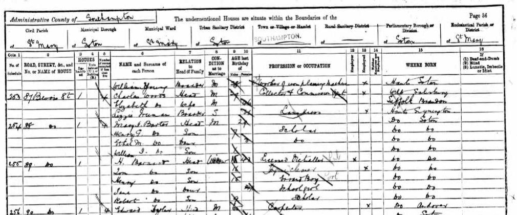
The Census states 87 Bevois St at the top of the page, which would make 89, Bevois Street as well. However, Bevois Street is to the north of Grove Street and was the first part of the District 35 walk. That part of the walk covers Bevois Street to the Railway Gates on both sides, nos. 1 to 49, odds and evens, then a gap followed by 92 to 143. Then Grove Street. The page above is flanked by Grove Street entries. District 37 has Bevois Street East of the Railway Gates. Nos 51 to 90, odds and evens, including 89, in District 37. I assume the building of the railway resulted in the demolition of nos. 50 and 91. It had a different family in 89 Bevois Street in District 37, I therefore conclude that the above 89 Bevois Street is in fact 89 Grove Street, the Star Inn from the 1901 Census, with the same family in both 1901 and 1891,
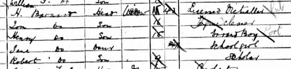
| Name and Surname | Relation to Head | Condition | Age last birthday | Estimated Birth Year | Gender | Occupation | Employer / worker | Neither | Where Born |
| H Barnard | Head | Widow | 43 | 1848 | Female | Licensed Victualler | Employer | Southampton, Hampshire, England | |
| Tom Barnard | Son | Single | 16 | 1875 | Male | Engine cleaner | Worker | Southampton, Hampshire, England | |
|
Henry Barnard
|
Son | Single | 15 | 1876 | Male | Errand boy | Southampton, Hampshire, England | ||
| Jane Barnard | Daughter | Single | 11 | 1880 | Female | School girl | Southampton, Hampshire, England | ||
| Robert Barnard | Son | Single | 9 | 1882 | Male | Scholar | Southampton, Hampshire, England |
I suspect this is the same family as in the 1901 Census, but the surnames of Tom and Henry don't match.
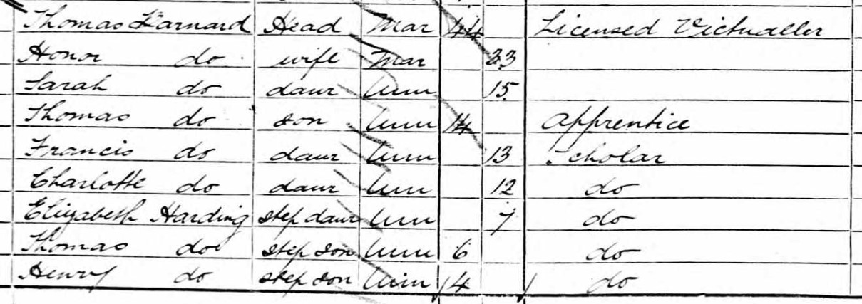
On the 1881 Census Honor Barnard has a husband, Thomas Barnard, and they are living with their family at 55 Bevois Street, St Mary, Southampton, Hampshire, England, Thomas Harding, 6 and Henry Harding 4, are step-sons of Thomas Barnard, and Elizabeth Harding 7 is his step-daughter. Sarah 15, Francis 13, and Charlotte 12 are his daughters, and Thomas, 14 his son, presumably from a previous marriage. That therefore makes sense with the 1901 Census having different surnames. Although, I can fully see why the transcriber went with Hurding instead of Harding as the 1881 image clearly shows.
According to the 1911 Census Honor Barnard was a Boarding House Keeper living at 34 Terminus Terrace, St Mary's, Southampton, Hampshire, England. She was living with two of her sons, Henry Hurding 34 and Robert Ernest Barnard 29.
Honor Hurding married Thomas Barnard in 1882 according to the marriage register, a year after they stated they were married on the 1881 Census. Honor Barnard died in 1927 at the age of 80, in Southampton. Was the surname Harding or Hurding. It is clearly both according to the Census papers, but the marriage register, if the same people, has Hurding.
A Honor Anteney married a Thomas Hurding on 10 March 1872, when she was 25 at Millbrook, Hampshire. Thomas Hurding died at the young age of 31 in 1878 leaving Mrs Honor Hurding a widow, able to marry Thomas Barnard in 1881/82.
The 1881 Census, Parish of St Mary's, District 23.
There is an enumerators note regarding the health of this District.
'The Health of the inhabitants of my district appeared to be extremely good. Only one slight case of disease among children having been met with, and that was chicken pox.'
For the 1881 Census the enumerator's walk starts at 1 Grove Street. Nos. are both odd and even. Between nos. 25 and 26 are the Alms Houses shown on the map on the West side of Grove Street.
Goddards Court, 1 to 6, is between nos. 42 and 43 Grove Street.
Grove Street School house is recorded between nos. 69 and 70.
New Court, 1 to 6, is between nos. 87 and 88 Grove Street.
Grove Street ends at no. 96 and the Census Record moves on to Church Street. I have yet to identify the location of Church Street as the roads at either end of Grove Street are Bevois Street to the North and Chapel Road to the South. Only one road off Grove Street and that is James Street. After Church Street in the Census Record is Western Terrace, Chapel Road. Which is at the southern end of Grove Street.
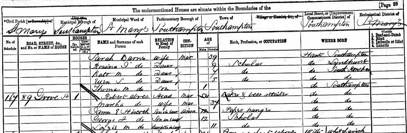
No 89 Grove Street has a family of three in residence.
| Name and Surname | Relation to Head | Condition | Age last birthday | Estimated Birth Year | Gender | Occupation | Where Born |
| Alfred H. T. Reynolds | Head | Married | 31 | 1850 | Male | Baker | Nursling, Hampshire, England |
| Ellen Rowenna Reynolds | Wife | Married | 31 | 1850 | Female | Romsey, Hampshire, England | |
| Thomas Henry Reynolds | Son | Single | 6 | 1876 | Male | Scholar | South Stoneham, Hampshire, England |
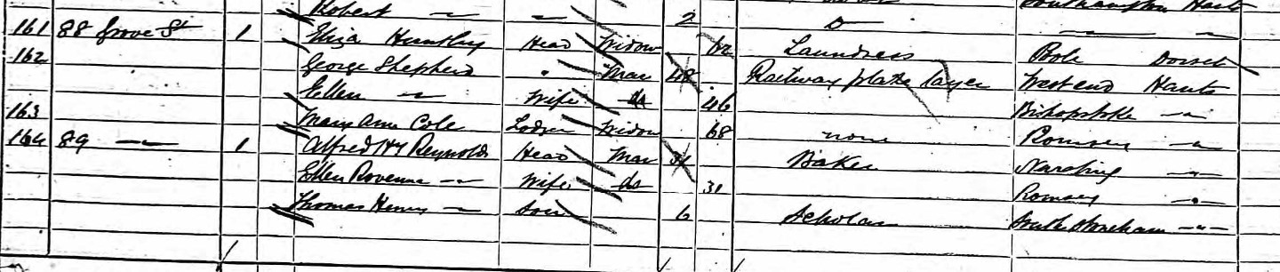
An aside. Nothing to do with 89 Grove Street other than the close proximity.
Ann Pomeroy residing at 4 New Court, just a few doors away from 89 Grove Street. Ann, a widow, 55 (1826), from Bridport, Dorset, living with her 17 year old (1864) son born in Freemantle, Hampshire, which is now a suburb of Southampton.
A Pomeroy married a Collins, at a later time, but that is a different story.
Courts off Grove Street.
Tucker's Court, a 19th century court in Grove Street. Appears to be between James Street and Bevois Street, on the West side of Grove Street form the OS 1870 Map.
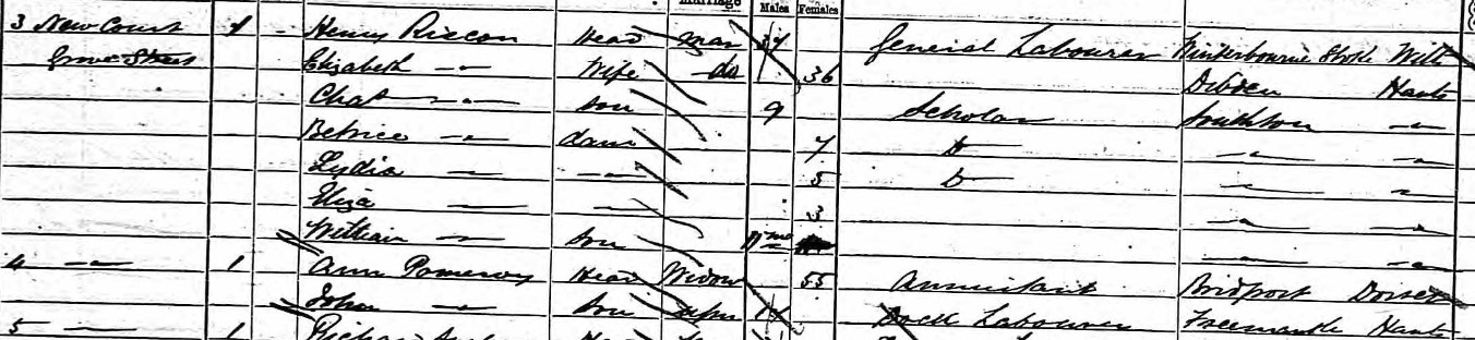
The 1871 Census, Parish of St Mary's, District 20.
| Name and Surname | Relation to Head | Condition | Age last birthday | Estimated Birth Year | Gender | Occupation | Where Born |
| Robert Abree | Head | Married | 54 | 1817 | Male | Baker & beer retailer | Southampton, Hampshire, England |
| Martha Abree | Wife | Married | 37 | 1834 | Female | Southampton, Hampshire, England | |
| James E Hiscock | Son-in-law | Single | 18 | 1853 | Male | Paper hanger | Southampton, Hampshire, England |
| George F Hiscock | Son-in-law | Single | 12 | 1859 | Male | Scholar | Southampton, Hampshire, England |
| Lizzie M Hiscock | Daughter-in-law | Single | 11 | 1860 | Female | Scholar | Southampton, Hampshire, England |
Robert Abree is also listed in in 1878 White´s History, Gazetteer and Directory, as a Baker and Beerhouse at 89 Grove Street, Southampton. He also appears as a voter in the Election of 12th July 1865, residing in Grove Street. Martha Abree, nee Ingram was previously married to Edward William Hiscock on 14 Dec 1851 at Southampton, Hampshire, England. They had four known children together, with three surviving in the 1871 Census. Edward William Hiscock died about 1865. Matha subsequently married Robert Abree, although I have yet to confirm this with a record.
The 1861 Census, Parish of St Mary's, District 18.
The numbering of Grove Street according to the 1861 Census Record
Tucker's Court, Grove Street; 1, 2, 3, 4, 5.
Goddard's Buildings Grove Street; 1, 2, 3, 4, 5, 6.
Grove Street; 1, 2, 3, 4, 5, 6, 7, 8, 9, 10 Somerset Arms, 11, 13, 14, 15.
Grove Street; 109 The United ??
Grove Street; 1, 2, 3, 4a, 5, 6, 7, 8, 9, 10, 11, 12, 13, 14, 15, 16, 17, 18, 19, 20, 21, 22, 23, 24, 25
Alms Houses Grove Street; 1, 2, 3, 4.
Grove Street; 27, 28, 29, 30, 31, 32, 33, 34, 35, 36, 37, 38, 39, 40, 41, 42, 43.
Grove Street; 1 Apollo Tap, 2, 3, 4, 5, 6, 7, 8, 9.
New Court Grove Street; 1, 2, 3, 4, 5, 6.
Grove Street; 10, 11, 12, 13, 14, 15, 16, 17, 18, 19, 20, 21, 22, 23, 24, 25, 26a, 27.
Grove Street; St Mary's National School House
Grove Street; 97, 96, 99, 100, 101, 102, 103, 104, 105, 106, 107, 108.
A very strange numbering system measured against today's norms, with at least three No 1 Grove Street, as an example.
Previous experiences suggest that sometimes it is a case of a row of houses, or terrace numbered 1 to ?? and this is then repeated in another terrace.
A similar pattern occurs in the previous 1851 Census below.
Given the different numbering system, and no reference Star Inn, there appears no way to be able to identify the particular property later identified as No 89 Grove Street.. The occupants of no 89 Grove Street in the 1871 Census are to be found elsewhere in earlier Census, so even the names do not give a hint of the location.
The 1851 Census, Parish of St Mary's, District 1o.
The numbering of Grove Street according to the 1851 Census Record
Grove Street; 1, 2, 3, 4, 5, 6, 7, 8, 9, 10, 11, 12, 13, 14, 15, 16, 17, 18, 19, 20, 21, 22, 23, 24, 25
Alms Houses Grove Street; 1, 2, 3, 4.
Grove Street; 27, 28, 29, 30, 31, 32, 33, 34, 35, 36, 37, 38, 39, 40, 41, 42.
Goddard's Buildings Grove Street; 1, 2, 3, 4, 5.
Tuckers Buildings Grove Street; 1, 2, 3, Unoccupied, 5
Grove Street; 1, 2, 3, 4, 6, 7, 8, 9.
New Court Grove Street; 1, 2, 3, 4, 5, 6.
Grove Street; 10, 11, 12, 13, 14, 15, 16, 17, 18, 19, 20, 21, 22, 23, 24, 25, 26, 27, Uninhabited.
Grove Street; 97, 98, 99, 100, 101, Uninhabited, 103, 104, 105, 106, 107, 108, 109.
Grove Street; 11, 10, 9, 8, 7, 6, 5, 4, 3, 2, 1.
Grove Street; 7,
A very strange numbering system measured against today's norms, with at least three No 1 Grove Street, as an example.
Previous experiences suggest that sometimes it is a case of a row of houses, or terrace numbered 1 to ?? and this is then repeated in another terrace.
Given the different numbering system, and no reference Star Inn, there appears no way to be able to identify the particular property later identified as No 89 Grove Street..
The 1841 Census, Parish of St Mary's, District 14.
The Census Record for Grove Street does not have house numbers. the Alms Houses are separately identified, but none of the courts or public houses until the Deanery on Chapel Road.
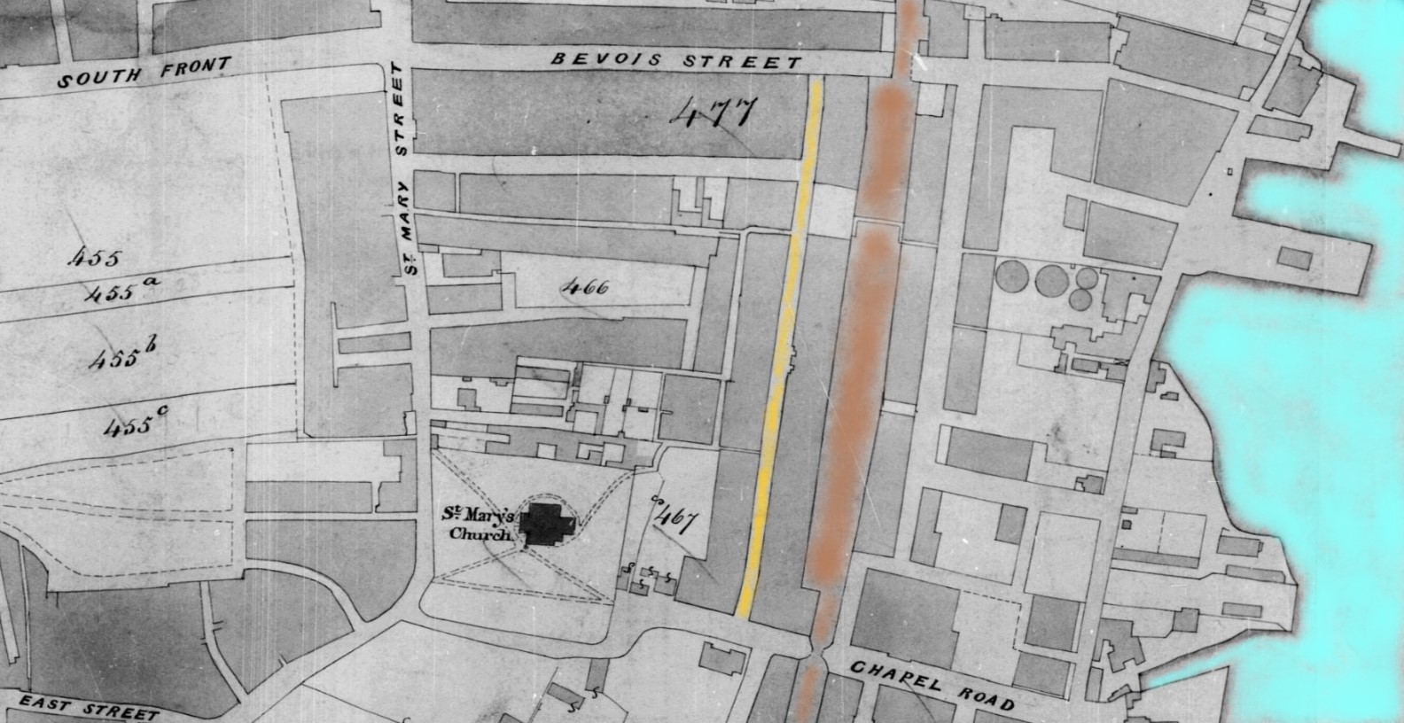
Tithe Apportionment and Map
The Tithe Apportionment is relatively late at 30th May 1851, compared to some of the others researched on this website. The Map is signed off by the Assistant Tithe Commissioner on 21st Sept 1852.
Normally that would provide a useful cross-reference to the Census of 1851. However, buildings don't produce crops or livestock, hence there is a lack of detail with the buildings being grouped into a large single plot, 477.
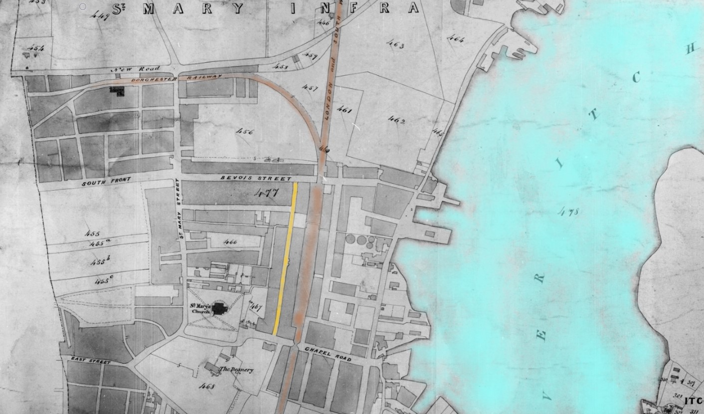
| Landowner Organisation | Town Portion of Saint Marys Infra |
|---|---|
| Parish | St Marys Extra, Southampton |
| County | Hampshire |
| Original Date | 30th May 1851 |
| Description of Land | Saint Mary's Infra, Buildings |
| Quantities In Statute Measure | 295,2,22 |
| Plot | 477 |
Within plot 477 is Grove Street, given a gold colour wash for easy identification. London and South Western Railway and Dorchester Railway are brown. I did think about using Malachite green, but that was more a later colour adopted by Southern Railway.
Locomotive liveries L&SWR
Liveries for painting of locomotives adopted by the successive Mechanical Engineers:
To 1850 (John Viret Gooch)
Little information is available although from 1844 dark green with red and white lining, black wheels and red buffer beams seems to have become standard.
1850–1866 (Joseph Hamilton Beattie)
Passenger classes – Indian red with black panelling inside white. Driving splashers and cylinders lined white. Black wheels, smokebox and chimney. Vermilion buffer beams and buff footplate interior.
Goods classes – unlined Indian red. Older engines painted black until 1859.
Southampton and Dorchester Railway
The Dorchester Railway shown near New Road did not last long as a separate company being amalgamated with LSWR in 1848.
Some of the roads are still identifiable today, and even part of Grove Street remains but the area has been redeveloped and repurposed. There is no evidence of 89 Grove Street now.
Enlightenment
I ordered a book online and it arrived today.
Southampton's Lost Streets St Mary and Golden Grove by Dave Marden
First published 2019 ISBN 978-1-78091-587-6
Chapter 2 of the book is entitled Grove Street and Bevois Street. It states that Grove Street and Bevois Street were two of the primary thoroughfares serving the area...
The author, David Marden apparently walked along Grove Street on his way to and from his Junior School.
He also recognises in the book the difficulties presented by the numbering system along the street having been changed several times. He does clarify that Grove Street retained its up and down numbers rather than switch to odds and evens.
Most of the buildings on the street were complete by the 1840's.
One of the great benefits of the book for me, apart from the general story telling, is the numbering of the houses along the street.
Going back a little, I used the layout or footprint of the plan included with the lease above. Both the two houses and the marks beside the plots which I assume to indicate the walls of the adjacent, and adjoining, walls. With this information, I tried to pattern match the outline of the house and size of the plot to match with the Southampton City 1870 map and secondly the OS 25" map, shown above.
I did look at the house that the book has annotated as number 89, but some elements matched the footprint, but others did not, so I continued looking for a better match. Surprisingly, there are not many of the houses with a similar pattern of in and out protrusions at the back of the houses.
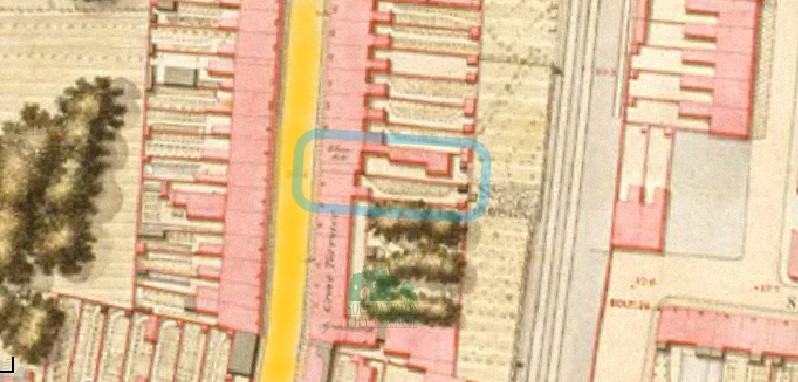 OS Map 1846 Southampton 89-90 Grove Street
Circled in blue is the 89-90 Grove Street based on the observations of the book. You can see from the map that in 1846 there is an extension in the back that is not on the lease plan in 1906, sixty years later. There is some writing on the map which could be Star Inn. It is not clear enough on the web version of the map to make out the letters. I think the houses with the trees in the back indicated on the 1846 Map are called Grove Terrace.
The same area but the 1870s map.
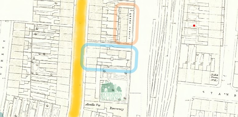 OS Map 1870 Southampton 89-90 Grove Street and New Court
The same pair of buildings circled in blue. the Star Inn was still open in 1870, but both the annotations shown on the 1846 map have been omitted from the 1870 map. The extension is still shown in the backyard of no. 89.
An addition to the 1870 map is a row of houses which appear to be annotated as James Court, but are otherwise known as New Court, circled in orange.
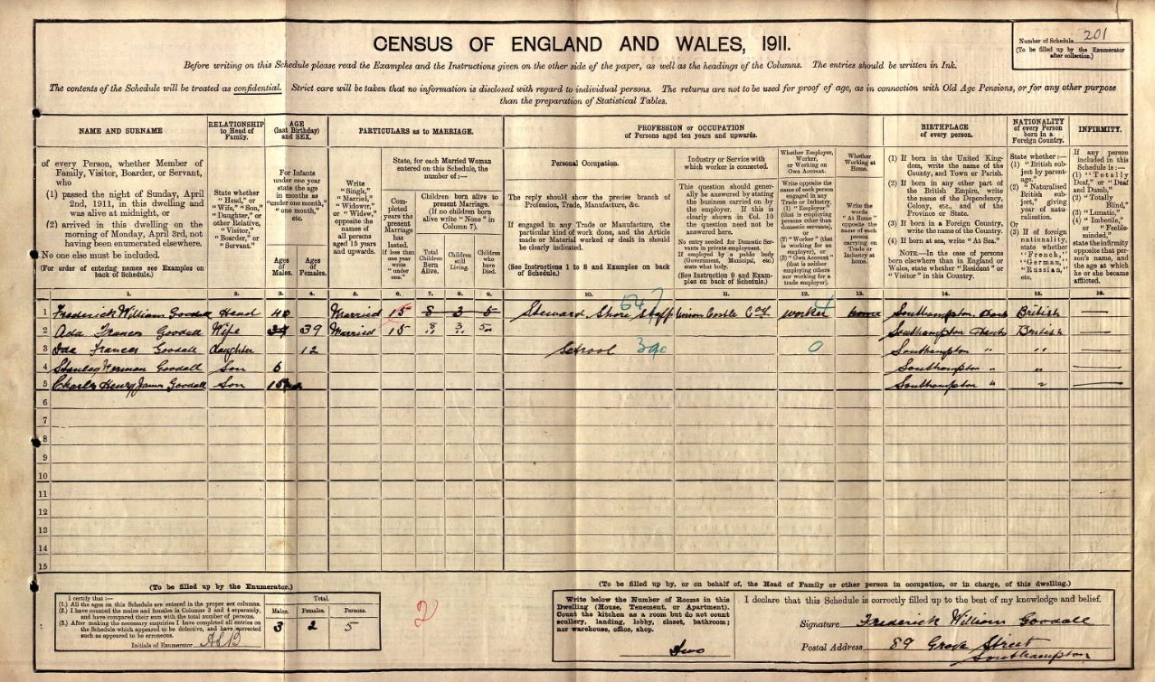
Going back to the 1911 Census, there are two families listed as living at no 89 Grove Street. Edward Collins and his family in four rooms and Frederick Goodall and his family, in two rooms.
Edward Collins from above; (Image of Census page above {1911 one page per family})
| Line No. | Name and Surname | Relation to Head | Condition | Age last birthday | Estimated Birth Year | Gender | Years married | Children born | Children still alive | Children who have died | Occupation | Employer / worker | Working at home | Where Born |
| 1 | Edward Collins | Head | Widow | 54 | 1857 | Male | House Carpenter | Worker | St Mary's, Hampshire, England | |||||
| 2 | Alice Collins |
Wife
|
Single | 37 | 1874 | Female | 16 | 3 | 3 | 0 | St Mary's, Hampshire, England | |||
| 3 | Elsie Collins |
Daughter
|
Single | 15 | 1896 | Female | St James | |||||||
| 4 | Letitia Collins |
Daughter
|
Single | 13 | 1898 | Female | St James | |||||||
| 5 | Kathrine Collins | Daughter | Single | 8 | 1903 | Female | St Mary's | |||||||
| 6 | Jessie Collins |
Daughter
|
Single | 22 | 1889 | Female | St James | |||||||
| 1 | Frederick William Goodall | Head | Married | 40 | 1871 | Male | Steward Shore Staff - Union Castle Co. | Worker |
Southampton, Hampshire |
|||||
| 2 | Ada Franes Goodall | Wife | Married | 39 | 1872 | Female | 15 | 8 | 3 | 5 | Southampton, Hampshire | |||
| 3 | Ida Frances Goodall | Daughter | 12 | 1899 | Female | School | Southampton, Hampshire | |||||||
| 4 | Stanley Herman Goodall | Son | 6 | 1905 | Male | Southampton, Hampshire | ||||||||
| 5 | Charles Henry James Goodall | Son | 10/12 | 1910 | Male | Southampton, Hampshire |
In the 1911 Census, from the records regarding 89 Grove Street, going back alone the Enumerators walk, assuming that is the order;
- 88 Grove Street, Charles Gates, Mellie Gates, and Mary Ann Privett - Mother-in-law, in 4 rooms
- 6 New Court, Grove Street, John Walker, and Mary Ann Walker, in 2 rooms
- 5 New Court, Grove Street, Georgiana Virgo, and Charles Loving - Boarder, in 2 rooms
- 4 New Court, Grove Street,
- 3 New Court, Grove Street, Joseph James Riggs, and Anna Elizabeth Riggs, in 2 rooms
- 2 New Court, Grove Street, Thomas Knowles, and Caroline Knowles, in 2 rooms
- 1 New Court, Grove Street, James Mason, and Annie Mason, in 2 rooms
- 87 Grove Street, Alfred Charles Gapper, May Gapper, Alfred Robert Gapper, and Edward Robert Gapper, in 4 rooms.
That makes sense with the book stating that New Court is only accessible through a narrow passageway between nos. 87 and 88 Grove Street, and that matches the 1870 Map above.
It is even easier to see in the 1901 Census, where the Enumerators route is continuous, not one detail page per family plus a header page, as found in the 1911 Census. New Court is between no 87 Grove Street (on the previous page) and 88 Grove Street. 89 is next, shown in the 1901 Census image above.
My conclusion is that 89 Grove Street is near the Chapel Road end, in the vicinity of New Court.
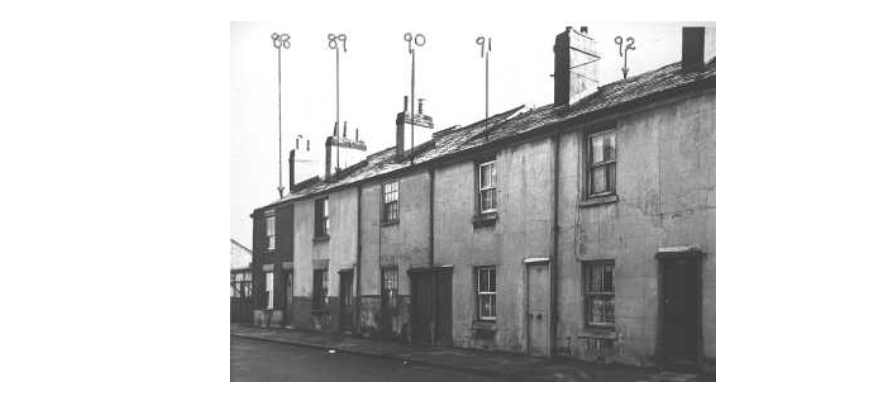
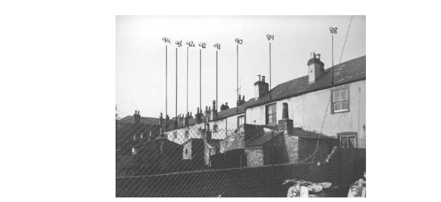
There is even a photo of 89 Grove Street included in the book.
Fortunately, Southampton Council undertook an extensive photo survey of properties before demolition.
Summary
Subject: Photograph. These houses, situated on the east side of the street, date back to the 1830s or 1840s. They were demolished c1960.
Record details
Main title:
88-94 Grove Street
Imprint:
Southampton City Council
1959
Collation:
Bitonal (1bit)
Credits:
SCC Archives Services
Click on the image to go to the source, where full page images are available.
{/sliders}