Turnpike Roads
What have Turnpikes to do with my family tree and history? As far as I am aware, none of my relatives were Turnpike Trustees. So why the interest on a genealogy site and not a history site? There are plenty of Turnpike background sites including of course Wikipedia. There are also some more detailed offerings by for instance Turnpike roads and and Tollhouses, This site was the source for the English Turnpike table and the Tollhouses of Hampshire table, both of which provided valuable information and further analysis. Another, British Tollhouses has photos of still existing tollhouses, although the actual gates have long since gone. An example is the Twyford Northern Gate which is included on my Census Map. Another possible Tollhouse on the same Turnpike can be seen on Google. Then you can get into even more detail with a paper on Hampshire Turnpikes and local websites for Southampton and a parish called Weeke near Winchester.
A small selection of turnpike facts;-
- The first turnpike road was established by Act of Parliament in 1663 to maintain a 15 mile stretch of the Great North Road near Royston in Hertfordshire. The Great North Road in part followed the older route of the Roman Ermine Street, London to York, and was the coaching route from London to Edinburgh, joining the two capitals. The first recorded stage coach operating from London to York was in 1658 taking four days. Faster mail coaches began using the route in 1786, By 1750 most of the major routes in England had been turned into turnpike trusts (Hey, 1996 p454)a quicker service from the other passenger coaches. In the "Golden Age of Coaching", between 1815 and 1835, coaches could travel from London to York in 20 hours, and from London to Edinburgh in 451⁄2 hours. In the mid-nineteenth century coach services could not compete with the new railways. The last coach from London to Newcastle left in 1842 and the last from Newcastle to Edinburgh in July 1847. The Great North Road is now substantively replaced by the A1 as it replaced the Old North Road and Ermine Street.
- By the 18th century the traffic on roads was rapidly increasing (relative term, not the M25) such that the statutory labour system based on the town or parish could not cope. Road condition had deteriorated to the extent that some were barely better than cart tracks. Despite this the pioneering solution was not copied until 1696. Then it started to catch on. By 1750 most of the major routes in England had been turned into turnpike trusts (Hey, 1996 p454).
- Note, History is about to repeat itself it the state of the local roads around Epsom are anything to go by. Perhaps the only well maintained roads in Epsom are the ones the Queen travels on on her way back from the Derby each year. :-)
- Turnpike roads are associated with the stage coach era. They became unprofitable with the coming of the railways and the decline of the long distance carriage traffic. From 1835, parishes were authorised by parliament to combine into groups called Highway Boards, to upkeep roads more efficiently. From this time the turnpike trusts were slowly replaced by these boards or committees of the new civil local authorities. During the 1850s and 1860s the condition of many turnpike roads deteriorated as trusts tried to pay off their debts. Most trusts were dissolved by the 1870s and 1880s, and in 1888 responsibility for main roads passed to the newly created county councils.
Historical Timeline
Timeline sources On This Day BBC, South Africa History, Wikipedia
- 8th July 1663 King Charles II of England grants a charter to Rhode Island. Part of the continuation of the early colonization of America.
- 27th July 1694 Bank of England granted 12 year charter by Act of Parliament, creating the possibly the world's first Central Bank. The Swedish and Dutch are also contenders. The establishment of the Bank of England, the model on which most modern central banks have been based, was devised by Charles Montagu, 1st Earl of Halifax, in 1694, following a proposal by the banker William Paterson three years earlier, which had not been acted upon. The Royal Charter was granted on 27 July through the passage of the Tonnage Act 1694. The bank was given exclusive possession of the government's balances, and was the only limited-liability corporation allowed to issue banknotes.
- 2nd September 1666, The Great Fire of London begins at 2am in Pudding Lane, 80% of London is destroyed. by 5th September The Great Fire of London ends, leaving 13,200 houses destroyed but amazingly only 8 people dead.
- 1712 - Thomas Newcomen invented the first productive steam engine. A necessary precursor to the Industrial Revolution. Initially used for the drainage of Tin mines but also spread to include Coal Mines. The Newcomen atmospheric engine gradually spread to more areas of the UK and mainland Europe and held its place without material change for about 75 years.
- In 1718, the Transportation Act introduced penal transportation. People convicted of capital crimes had their sentences 'commuted' to 14 years or life in the Americas. Convicts found guilty of non-capital crimes received seven-year sentences.
- From the 1750s, landlords in the Scottish Highlands began to forcibly remove tenants from their land, usually to replace them with more profitable sheep farming. The clearances resulted in whole Highland communities leaving Scotland and emigrating, most of them to North America. Many others moved to growing urban industrial centres such as Glasgow. This was part of a broader process of agricultural change in Britain, but in the Highlands it was marked by particular abruptness and brutality.
-
The elements of the industrial revolution begin to take shape.
1694 - First Central Bank established in England
1712 - Thomas Newcomen invented the first productive steam engine
1719 - John Lombe starts his silk factory
1733 - James Kay invented the Flying Shuttle, a simple weaving machine.
1764 - James Hargreaves invented the Spinning Jenny, which allowed one worker to spin eight spindles
1769 - Richard Arkwright invented the water frame, which hooked up spinning machines to a water wheel.
1769 - James Watt patented his revision of the steam engine, featuring a separate condenser.
1774 - Samuel Crompton invented the spinning mule which combined spinning and weaving into one machine.
1776 - Adam Smith published The Wealth of Nations.
1781 - Watt adapts his steam engine from a reciprocal to a rotary motion.
- 1771
'Factory Age' begins with the opening of Britain's first cotton mill
The weaving of cotton cloth had become a major industry by the 1760s, with most of the labour being done by people in their homes. In 1771, inventor Richard Arkwright opened the first cotton mill at Cromford, Derbyshire. The spinning of yarn was carried out by his own patented machine, known as a water frame. This was a significant step towards the automation of labour-intensive industries and heralded the beginning of the 'Factory Age' in Britain. - 18 April 1775
American War of Independence begins
On 18 April 1775, a skirmish between British redcoats and the local militia at Lexington, Massachusetts, led to the fighting that began the American War of Independence. No one knows which side fired the first 'shot heard around the world'. About 15 months after the outbreak of war, colonial leader Thomas Jefferson drafted the Declaration of Independence, which argued that the goals of the United States of America were 'life, liberty and the pursuit of happiness'. In September 1783, the Treaty of Paris formally ended the war. - Possibly the real First World or Global War.
The Anglo-French War was a military conflict fought between France and Great Britain with their respective allies as part of the American Revolutionary War between 1778 and 1783. In 1778, France signed a treaty of friendship with the United States. Great Britain was then at war with France, and in 1779 it was also at war with Spain. As a consequence, Great Britain was forced to divert resources used to fight the war in North America to theatres in Europe, India and the West Indies, and to rely on what turned out to be the chimera of Loyalist support in its North American operations. From 1778 to 1783, with or without their allies, France and Britain fought over dominance in the English Channel, the Mediterranean, the Indian Ocean and the West Indies.
Within days of the news of General Burgoyne's surrender reaching France, King Louis XVI decided to enter into negotiations with the Americans that resulted in a formal Franco-American alliance and the French entry into the war, moving the conflict onto a global stage. The Saratoga Campaign in 1777 was an attempt by the British high command for North America to gain military control of the strategically important Hudson River valley during the American Revolutionary War. It ended in the surrender of the British army under General Burgoyne, which historian Edmund Morgan argues, "was a great turning point of the war, because it won for Americans the foreign assistance which was the last element needed for victory." Spain did not enter into the war until 1779, when it entered the war as an ally of France pursuant to the secret Treaty of Aranjuez. Vergennes' diplomatic moves following the French war with Britain also had material impact on the later entry of the Dutch Republic into the war, and declarations of neutrality on the part of other important geopolitical players like Russia.Opposition to the costly war was increasing, and in June 1780 contributed to disturbances in London known as the Gordon riots.
The two protagonists in the naval showdown in the Indian Ocean had as their objective the political dominance of the Indian subcontinent, and a series of battles fought by Admirals Edward Hughes and Pierre André de Suffren in 1782 and 1783 offered France a position to displace the British from its territories. The opportunity only ended when Suffren and Hughes had to stop fighting upon learning of the provisional Anglo-French-Spanish peace treaties of 1783.
Perhaps give away the emerging America which did not want to pay taxes for it's own protection, and keep the more lucrative India.
So, something for you to contemplate. Did the young America instigate the first ever global confrontation, or were they just a contributory circumstance? Perhaps it was an opportunistic Louis XVI of France taking advantage of the situation to grab land, power, and wealth at a time when times at home were difficult, just before the French revolution? Or alternatively, it was France who precipitated the whole conflict by its aggressive moves on the North American continent which resulted in the British imposing taxes on the Colonists to help pay for their protection against France, leading directly to the Boston Tea Party and perhaps also the American War of Independence? Then perhaps the Spanish and Dutch joined in for the same reasons, of land, power, and wealth, or just out of a desire for revenge against the things Britain had done to them over time.
The timeline could be peppered with wars and conquests. However, I think it is more interesting to note the correlation between the progression of the Industrial Revolution which was seeded well before the sometimes quoted start of 1760's and the proliferation of a more effective road transport network between 1700 and 1750 which together with the canal network for bulk transport provided an implementer or enabler for the revolution. Challenged by the railway boom of the 1840s and set on a route of decline. The agricultural revolution was also an enabler of the Industrial Revolution and was approximately concurrent. An article on this site is about the Tolpuddle Martyrs. The change in agriculture provided the migration to the cities to provide the labour force for the new factories. Or was the cause and effect the other way around? A definite interdependence of all of the circumstances.
Back to the first question
What have Turnpikes to do with my family tree and history? Well I have an interest in people migration as part of Family History. That can be Joan Hurst and others travelling on the Mayflower to colonize North America, The Leventhal Brothers, Russian Jews escaping current Poland first to USA and then to Australia, or more local migrations from Dorset to Hampshire. The socio/economic migrations are also reflected on a smaller scale within generations of the same family and within the confines of a single Parish or County area.
Normally, a search of the census records provide information about a single family on my tree, and the specific data in incorporated in my tree to provide additional information and validity to the persons on my tree. However, if you stand back from that data and look at the whole census for that Parish it can provide a huge amount of additional information ripe for analysis. The first part of the exercise is to establish the boundary of the Parish, and the boundary of the census by looking at the Enumerators Notes on page 1 or 2 of the census. Some of the place names are recognisable and easily found on a current map. Others less so, with road name changes and villages and hamlets being absorbed into larger urban areas. Out comes the old maps, generally from the National Library of Scotland. Access at time of writing is free of charge for non-commercial use. This helps locate more of the places named within the notes. However, using the Millbrook 1841 Census as an example, where the Parish is divided into 7 Districts. Each District is allocated to a different Enumerator, with a distance to travel and a number of homes to ask the required questions, all achievable, within the single census day. Almost all of the notes refer to the Turnpike as part of the route. This cannot be the same Turnpike in all instances because of the physical constraints of the route. Hence it is necessary to understand which roads are Turnpikes and the route they took at the time of the census to help understand the real boundary of the particular Enumeration. Understanding the area helps interpret the locations of the buildings covered within the Census. Named building which correlate with both the area and the Old map can provide a definitive place on the Enumerator's route. This can be recorded as a form of universal reference such as Latitude and Longitude or What3Words. Older references such as OS Grid can also be converted by sites such as Grid Reference Finder. Ordnance Survey map app can help with current data as well as Google, Bing, and Open Street Map. There are other mapping services available. Using this information I develop a personal Google map with the known information.
The map below is the result of adding Turnpike data of the area to a current Google map, and any information found so far.
The map can be enlarged by the icon top right and a menu shows with the icon on the top left. Layers with information on Turnpike roads and tollhouses, as well as individual Census Districts can be turned on or off.
Moving on from the Google Maps version, I have been developing similar in ESRI mapping.
I have started a Millbrook version, and it may appear here when it has progressed further. I have also been working on a map of the Biddlecombe's of Eling, which again involves Turnpikes.
The Biddlecombe map is below. There is a layer called Turnpikes, which if left ticked whilst unticking all of the other layers, shows just the Turnpike Approximate routes together with some gate information.
Maps
Some of the Toll House or Toll Gate information comes from the Tithe Apportionment and Map information. Again it has to be found and matched on an old OS Map such as this 25" one of the Petersfinger area, near Salisbury.
The matching extract from the Eling Tithe Map is below, .together with the Tithe Apportionment transcript data.
 |
|
Sarum & Eling Turnpike Trust 1753 Petersfinger Gate 51.061806, -1.767434 |
||||||||||||||||
 |
|
Sarum & Eling Turnpike Trust 1753 Lyndhurst 50.873520,-1.576695 |
||||||||||||||||
 |
|
Sarum & Eling Turnpike Trust 1753 Great Testwood 50.923129,-1.495727 |
||||||||||||||||
 |
|
Sarum & Eling Turnpike Trust 1753 Totton 50.918819,-1.487697 |
||||||||||||||||
 |
|
Sarum & Eling Turnpike Trust 1753 Netley Marsh 50.915212,-1.518872 |
||||||||||||||||
Moving away from the detail found on the Tithe Apportionment Maps and Records, and looking at another potential source of information, the British Library Online Gallery. Of particular interest was the Salisbury Map which includes the New Forest. Our area of interest at the moment.
I explored Salisbury first, and happily found three references to Turnpike gates. I was hopeful. The best view is the interactive but it requires Adobe Flash, which is becoming redundant. The extracted images below are enlarged screenshots
 |
Part of the British Library Online exhibitions, Ordnance Survey drawings, as Salisbury 19
Draughtsman: [Crocker, Edmund] Medium: Pen and ink on paper Date: 1807 Map scale ratio: 2'' : 1 Mile (1 : 31680)
|
|
| This drawing is rich in archaeological sites, among them the prehistoric monument known as Stonehenge. Situated on Salisbury Plain, it is the most celebrated megaithic monument in England. The iron-age hillfort of Old Sarum is also marked. A castle and cathedral were built on its earthworks during the 12th century, but abandoned when a new cathedral was built a mile and a half away - the foundation of the modern city of Salisbury. The red line extending from Old Sarum to Beacon Hill is the baseline for the triangulation of the area. Several other archaeological sites are marked: the iron-age hillforts at Vispasians Camp, Ogbury Camp and Clorus's Camp. | << The description of the Map by the British Library. | |
| I recognise that this is illegible as it is and needs the interactive zoom on the website together with a hand held magnifying glass to be able to discern the details and text. Scanning for turnpike gate text is a case of moving the map on screen in a down, across, and back up pattern, until the whole map has been covered. Then print screens at the items found, processed to double size. Tempted to go bigger but resolution starts to go off. Results below. | ||
 Turnpike Gate at Lopcombe, about center of map near Bishop's Down Hill Turnpike Gate at Lopcombe, about center of map near Bishop's Down Hill |
It appears that the Turnpike gate at |
Sarum & Eling Turnpike Trust 1753 Another link to OS Map, a 1" with hills. Only Approximate 51.085170,-1.776052 |
| Peter's Finger, near the River Avon, has a Turnpike Gate in the location ascertained from the Tithe Map, as described above. |
|
|
| On the other side of Salisbury, another Turnpike is shown near Fisherton Anger. | ||
 |
Unfortunately, no luck looking for the Furzy Lawn Toll Gate | |
 |
Ranvill's gate Also Ranville's. This is on the route of the Romsey and Ringwood Trust. It could be any gate as it does not name it as a turnpike gate. Added to the ESRI map dispite not being confirmed by other records. |
Approximate location, 50.974550,-1.518525 |
 |
Lockhill gate | |
 |
Lockerly (hole in paper) someting, Green or perhaps Gate | |
 |
Wallops Direction posts | |
 |
Sparsholt / Pauncefoot Hill, Romsey Turnpike gate |
|
| Lets go back even further in our mapping, | ||
| So far the earliest map of this area of Hampshire is the below extract from Sexton's 1775 Map. | ||
 |
Well before the Turnpikes started crossing Hampshire. Showing Lyndherst and The New Forest. |
SU20 slice of Sexton's 1575 Map |
 |
Senex's maps on a different format. |
trip map, road map, hand coloured engraving, scale about 2-2.5 miles to 1 inch, The Road from London to Pool in Dorsetshire, segment from Alresford, Hampshire to Poole, Dorset and from there to Lymington, Lymington, and from Southampton to Winchester, Hampshire. Senex's preface:- |
 Extract of a '1 inch to 1 mile' map of Hampshire surveyed by Isaac Taylor, engraved by R Benning, published 1759 showing Lamb's Corner Map Extract of a '1 inch to 1 mile' map of Hampshire surveyed by Isaac Taylor, engraved by R Benning, published 1759 showing Lamb's Corner Map |
This map may have been surveyed before some of the Turnpikes included in this article were built. I have not yet found any mention of Turnpike Gates on this map. It does however show Lamb's Corner, which is mentioned in one of the Newspaper articles about the SARUM AND EALING TURNPIKE Trust, but not the associated Hampton Ford. |
|
 Extract from a '1 inch to 1 mile' map of Hampshire surveyed by Thomas Milne, published by William Faden, 1791 showing Lyndhurst Toll Gate and Racecourse Extract from a '1 inch to 1 mile' map of Hampshire surveyed by Thomas Milne, published by William Faden, 1791 showing Lyndhurst Toll Gate and Racecourse |
With publication just 32 years after that of Isaac Taylor the map has changed. Lamb's Corner appears to have moved significantly and it is questionable if the road from Lamb's Corner to Minstead, on the way to Ringwood, is shown on Milne's map at all. Is this part of the impact of toll roads? Perhaps, despite the charge, they are so much more popular that the other roads to the same place fall out of use. Lyndhurst has a Toll Gate shown at about what is now Racecourse View. the Race Ground is also shown. To the North of Lyndhurst Furzy Lawn Enclosure is also shown, with a milestone, but without a Toll Gate or House. It is evident from the inspection of the map that not all Toll Gates are mapped. Hence the absence of one, is not of concern, irrespective of whether it is in a town, where there is little room to add additional text to the map, or rural areas, where there is more space. |
|
 The same Milne's Map but further North than the last, centred on District 1 of 1841 Census of the Parish of Eling The same Milne's Map but further North than the last, centred on District 1 of 1841 Census of the Parish of Eling |
Paulton's Park is in the middle of the extract. It is no longer a Country House with the house demolished but is now a Theme Park currently called Paultons Park Home of Peppa Pig World. It is anotated on the map with Welbore Ellis Esq. He was created 1st Baron Mendip, of Mendip in the County of Somerset, in 1794 in recognition of his governmental service, sometime after the publication of this map. Moving across to the right towards the River Test. Shown on the map as Anton or Test River. It is now considered that Anton is a tributary of the Test. Little Testwood and Great Testwood are shown on the map, and both are recorded elswhere as having Toll Gates / Houses. Anjacent is the Testwood House shown as owned by Peter Serle Esq. the son of Gilbert Searle. Further right, across the Test, at Nutshaling, now known as Nursling, is Grove House, latterly Grove Place, is the home of Sir Charles Mill. He is a significant landowner in Millbrook as demonstrated with his ancesters, within the article here, Millbrook Parish One Place Study, and in particular with this coloured Tithe Map. |
|
 The same Milne's Map but further West than the first, showing a Turnpike west of Ringwood and a Toll Gate to the East on the road to Romsey The same Milne's Map but further West than the first, showing a Turnpike west of Ringwood and a Toll Gate to the East on the road to Romsey |
On the extreme left, parallel to the River Avon at Ringwood the word Turnpike is written. South of there I was attracted to Avon Cottage, owned by Drummond Esq. Wondering if Avon Cottage was anything to do with the Sopley and the Domesday Book and Tilley family migration I looked for the cottage on a later OS 25" Map and found it to be Avon Castle, somewhat North of the Sopley Parish and village. Another reference to turnpikes is the Toll Gate near the center of the map, not far from Picked Post. Now known as Picket Post, with a house named 'Dilamgerbendi Insula' on the OS 25" Map. A short distance futher, towards Romsey, an old gate and a Mile Post are shown on the same map. |
|
 |
As can be seen, the amount of information about the Turnpikes varied considerably, even between map extracts in close proximity. So many interesting things on this map. Some Turnpike related, others not. There is a name of a Turnpike opposite Broadlands Park,on the road to Salisbury.On the East side of Romsey, previously Rumsey, there is Huntred Gate Turnpike, about where the Hundred is now. To the North can be found Timsbury Bridge Turnpike. On a road going west from the Timsbury Bridge Turnpike is Standbridge, just south of Awh Turnp. Was this linked to Standbridge Estate, Standbridge and Standbridge Erles and the Fifield family. Possible ancesters. South from there, Sparsholt Tower with Lord Palmerston, and back across the River Test to Broadlands Park and Ld Viscount Palmerston Top left of the map there is a Bye Gate, presumably Turnpike, and bottom centre, Ranvills Gate. Compared to the previous map around Ringwood, this is awash with Turnpike information, but is still only a fraction of the locations. Another home, Embley House, owned by Sir William Heathcote, Bart. He and his son Thomas enlarged the estate, added to the house, and laid out drives and gardens. Following Thomas's death in 1825, the estate passed to William Heathcote who sold Embley to William Edward Nightingale, the father of Florence Nightingale. |
Map of Hampshire Thomas Milne, 1791 - Introduction. OS 25" Romsey, Sun Arch (The railway bridge near the T. Pike.) |
 |
Moving on to a different Map Maker. A different style. As for Turnpikes, a noticeable absence of Gate annotations. It does show the position of Laurel Cottage, North of Cadnam which is mentioned in the District 1 part of the 1841 Census. That will help with plotting the Enumerators Route. |
Greenwood's Hampshire 1826 - Introduction OS 25" Cadnam, Coppithorn Hill, Copythorne and Laurel Cottage |
 |
Finally, the Ordnance Survey. Slightly out of chronological order as this is 1810 and Greenwood's was 1826. However, the series goes from 1810s to 1840s, so perhaps not out of order. A general lack of Turnpike information. However, East of Ringwood, on the Romsey Road, near Picked Post, there is an annotation of T. Pike in the same location as the Thomas Milne, 1791 map of the same area, mentioned above. I also noticed the Hurst Farm north of Ringwood, an ancestor perhaps. |
Ordnance Survey 1" to the mile first edition, Old Series. - Introduction |
 |
A repeat of the Lyndhurst mapping, also showing the Race Course. However, T. P. is not in the location of Racecourse View. There is another T.P. south of Lyndhurst. |
Ordnance Survey 1" to the mile first edition, Old Series. - Introduction |
 |
Centred on Romsey. T. Pike on the road East, towards Winchester, at the crossing with the railway marked Salisbury. Ranvills Gate again with no extra clarity regarding if it is a Turnpike Gate. Ranvills is not a stately home so it is unlikely to be that sort of gate. The Ranvills Farm is also shown, presumably the derivation of the Gates name. My assumption at the moment is that it is a Turnpike Gate. Lockhill Gate, as previously shown on British Library held map above. Considering the number of Turnpike Roads and Gates in and around Romsey, the map contains very little information about them. Perhaps this is an indication of how accepted and ordinary they had become. |
Ordnance Survey 1" to the mile first edition, Old Series. - Introduction OS 25" Romsey, Sun Arch (The railway bridge near the T. Pike.) |
| A brief walk through maps and turnpikes. Sexton's 1575 Map to Ordnance Survey 1" to the mile first edition, Old Series, 1810 to 1840. |
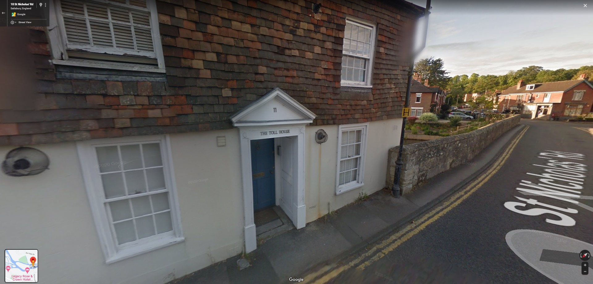 Sometimes there is much more certainty regarding location as the building associated with the turnpike gate still exists.
This building is called 'The Toll House' on St Nicholas Road adjacent to the River Avon in Salisbury Wiltshire. The bridge was previously called Harnham Bridge, one of the extremities of the Sarum and Eling Turnpike Trust according to the original Act of Parliament.
However, not all is always as it seems.
The house next door looks suspiciously more like a toll gate house than the larger, more affluent house now called 'The Toll House'. Unfortunately I have not found any Tithe Maps covering this area which may have provided more definitive information. Also, as yet I have not looked at the 1841 Census to check for the occupation of the inhabitant of either property.
Either house still gives a very accurate gate location for mapping purposes.
Sometimes there appears to be conflicting information about the location of the Turnpike Gates, and sometimes the name. Perhaps one place on the Tithe Map and another on an OS Map. This is not necessarily a discrepancy. The following extract from the New Forest Explorers Guide has an interesting example.
The Salisbury, Landford, Ower and Eling Turnpike Trust, 1753
From 1753 to 1870, the Salisbury, Landford, Ower and Eling Turnpike Trust operated between Salisbury and Eling along today’s A36 through Ower; and also between Eling and Cadnam along the A336, with, in 1771, a branch road into Lyndhurst along the current A337 Cadnam road.
") Turnpike Cottage (F), opposite Racecourse ViewTurnpike Cottage (F), opposite Racecourse View /> Turnpike Cottage (F), opposite Racecourse View
Turnpike Cottage (F), opposite Racecourse ViewTurnpike Cottage (F), opposite Racecourse View /> Turnpike Cottage (F), opposite Racecourse View
The Lyndhurst toll gate was originally 2 kilometres (1¼ miles) outside the village, not far from the turn for Minstead, but was eventually moved to the small black and white house, Turnpike Cottage (F), opposite Racecourse View on the outskirts of the village.
But to ensure that travellers from Pikeshill had to pay the tolls, it was moved again, this time to the delightful thatched cottage (G) opposite the Penny Farthing Hotel. Pikeshill residents, though, in 1834 successfully petitioned the Trust, and the gate was moved back to Turnpike Cottage.
A simple, two-sided milestone can still be found beside the A337 road leading towards Cadnam, close to where the original tollgate would have been. Badly worn, weather-beaten and ivy-clad, it is marked ‘Sarum 17, Romsey 9’. Why Sarum and Romsey is a bit of a puzzle. To reach these destinations, travellers perhaps connected at Cadnam with coaches of the Romsey and Ringwood Turnpike Trust, 1758, running on what is now the A31.
") Thatched cottage (G) opposite the Penny Farthing Hotel
Thatched cottage (G) opposite the Penny Farthing Hotel
The 2 kilometres (1¼ miles) outside the village mentioned above equates to being just north of Bartley Water by the Kennels. However, another source puts the toll house to the South of Bartley Water. This would be the gate known as Furzey Lawn, which is also the name of an Inclosure (Enclosure) on the north bank of Bartley Water. I have plotted the gate as being just South.
The Thatched Cottage as a Turnpike Toll House was known as the Pike's Hill gate. The Pike's Hill gate did not last long reverting to the Turnpike Cottage.
On the 11th May 1838 the Tithe Map surveyors recorded a plot 71 with the land owner being the Commissioners of the Sarum & Eling Turnpike and the occupier as being James Green. Plot 71 is in the vicinity of King's Close.
Four different locations for the gate towards the Lyndhurst end of the Turnpike, Furzey Lawn Gate, Turnpike Cottage, twice, Pike's Hill Gate, and Tall (Toll) House at Plot 71.
British History Online
Some of the Turnpikes in Hampshire emanated from and were controlled from Wiltshire. There is an interesting article about Wiltshire Turnpikes in British History Online, including a map of the Turnpikes.
An extract;
In 1753 south Wiltshire came into the turnpike system for the first time, with the authorizing of trusts for the roads from Whitesheet Hill in Donhead St. Andrew to Shaftesbury (22) and from Lopcombe Corner in Winterslow to Salisbury, and thence nearly to Southampton (23). This latter trust became responsible in 1772 for the upkeep of footpaths in Salisbury. Between 1754 and 1756, the two routes from Basingstoke, meeting at Lopcombe Corner (24, 26), and the Salisbury-Romsey road from Whiteparish to Romsey (25) were added to the list, as also were the Mere-Wincanton (27) and Salisbury-Blandford (29) roads. The Salisbury-Romsey road was apparently a very good one, for Arthur Young said it had 'more the appearance of an elegant gravel walk than of an high road'. (fn. 34) He attributed its condition to the good management of the trustees, that is, presumably, the trustees of both the Salisbury—Southampton road and the Salisbury-Romsey road. A group of roads centred on Poole, turnpiked in 1755–6, included a branch towards Salisbury (28), but the branch was omitted from the renewal Acts until 1818.
...
Apart from some trusts whose routes touched Wiltshire only for short distances on the border, or affected only detached parts, only two more trusts remain to be mentioned. One, from the outskirts of Shaftesbury, wound a tortuous route along the southern boundary into and out of Wiltshire, Dorset, and Hampshire, eventually reaching Brook in the New Forest, with a branch to Downton (61). This was turnpiked in 1831–2.
The other was one of the latest roads in England to be turnpiked, in 1840. This, too, pursued a tortuous course (62). It started at West Kennett, near Beckhampton, on the London—Bath road, crossed the downs near Knap Hill in Alton Priors, and continued to just north of Amesbury with offshoots in Netheravon, Figheldean, and Enford.
By this time, the death knell of the turnpike system had been sounded. Trains were already running on the Great Western Railway: (fn. 39) the hey-day of the 'coaching era' was past. The peak of road development had been reached by the eighteen-thirties. The work of Telford and Macadam, the former chiefly devoted to engineering and the latter to surfacing, was mainly carried out in the twenties and early thirties. Macadam's work was chiefly in the west of England, and he or one of his sons was surveyor to many Wiltshire trusts: the trusts based upon Devizes, Market Lavington, Salisbury, Warminster, Westbury, Melksham, Bath, and others all availed themselves of the services of the family.
| App No. | Title | Year of 1st Act | Act by which a road was first authorized to be turnpiked. | Added; Act Title |
|---|---|---|---|---|
| (22) | The Shaftesbury and Sherborne Roads | 1753 | 26 Geo. II, c. 60. A. | Wiltshire, Dorset and Somerset Roads Act 1753 |
| (23) | The Salisbury and Southampton Roads | 1753 | 26 Geo. II, c. 66. A. | Wiltshire and Southampton Roads Act 1753 |
| (24) | The Salisbury and Basingstoke Road, via Andover | 1754–5 | 28 Geo. II, c. 44. A. | Wiltshire Roads Act 1755 |
| (25) | The Salisbury and Southampton Road, via Romsey | 1755–6 | 29 Geo. II, c. 45. A. | Wiltshire and Southampton Roads Act 1756 |
| (26) | The Salisbury and Basingstoke Road, via Stockbridge | 1755–6 | 29 Geo. II, c. 46. A. | Stockbridge Roads Act 1756 |
| (27) | The Wincanton Roads | 1755–6 | 29 Geo. II, c. 49. A. | Wincanton Roads Act 1756 |
| (29) | The Salisbury to Blandford Road | 1755–6 | 29 Geo. II, c. 54. A. | Wiltshire and Dorset Roads Act 1756 |
| (61) | The Cranborne Chase and New Forest Road | 1831–2 | 2–3 Wm. IV, c. 64 (Local and Personal Acts). A. | |
| (62) | The Kennett and Amesbury Road | 1840 | 3–4 Vic. c. 11 (Local and Personal Acts). A. |
While we are looking at the various Acts of Parliament enacting the Turnpikes here is the one bringing on the end.
Annual Turnpike Acts Continuance Act 1872
Newspapers
Maps are not the only source of information about the Turnpikes. The Newspapers are also a good source of information, with various announcements, including AGM and auctions of investment opportunities. The latter sometimes listing all the gate and sidegate names.
Also found were annual Government returns, the 1871 return included below, shows the extent of the debt towards the end of the era of the Turnpike.
The following extract, found here, is from;
The Salisbury and Winchester Journal and General Advertiser of Wilts, Hants, Dorset, and Somerset
Date of Article: 24/08/1829
Printer / Publisher: W.B. Brodie
Address: The Printing Office, Canal, Salisbury,
(Note the copied text had no paragraphes, so the breaks may be incorrect)
AMESBURY TURNPIKE ROAD. NOTICE is hereby given,— That a Meeting of the Trustees of this Turnpike will be holden at the George Inn, Amesbury, in the county of Wilts, on THURSDAY the 27th day of August inst. at eleven o'clock in the forenoon, pursuant to adjournment. Aug. 1, 1829. J. M. HODDING, Clerk. Fisherton, Wilton.
Heytesbury, Willoughby Hedge, and Redhone Turnpikes. NOTICE is hereby given,— That, a Meeting of the Trustees of these Turnpike Roads will be holden at the house of James Davies, known by the name of Deptford Inn, in the county of Wilts, on Wednesday the ninth day of September next, at eleven of the clock in the forenoon, pursuant to adjournment. MATTHIAS THOMAS HODDING, Clerk. SALISBURY, Aug. 13, 1829.
1874 SARUM AND EALING TURNPIKE. NOTICE is hereby given,— That the Trustees of the Turnpike Roads under the several Acts passed in the reign of their late Majesties King George the Second and King George the Third, " For repairing and widening the Roads leading from Lobcombe Corner, in the parish of Winterslow, to Harnham Bridge, in the county of Wilts, and from the west corner of Saint Anne's street, in the city of New Sarum, to the parishes of Landford and Brooke, and from thence to Ealing, and from Landford aforesaid through Ower and Testwood to Ealing aforesaid, in the county of Southampton ; and for repairing and widening the road from the Romsey and Ringwood turnpike road, near the house of Francis Fry, to Lyndhurst, and from a place called Hampton Ford to Lamb's corner, in the county of Southampton, being assembled this fourteenth day of August instant, to enforce tile directions of the several Acts passed in the 3d and 4th years of the reign of his present Majesty King George the Fourth, " For regulating Turnpike Roads, and in pursuance of public Notice given in writing, upon all the Toll Gates erected on the said road, and also in the Salisbury Journal, circulated in this part of the county previous to the taking the Order herein after mentioned into consideration. Did Order that a Toll Gate should be erected at or near Landford Bridge, leading from Bramshaw to Sarum, on the side of the said Turnpike, across a certain Highway there leading to Hamptworth and Downton; and that the like Tolls be taken at such Gate as are authorized to be taken at the other Gates erected on this Turnpike, so as that the same do not extend to a double Toll; and that the inhabitants of Hamptworth, living near the road leading from Hamptworth to Downton, be exempted from the payment of any Tolls at the said Side Gate; and also that such Tolls do commence and be taken thereat from and after Monday the 24th day of August instant— Dated this l4th day of August, 1829. 883J EDW. DAVIES, Clerk to the Trustees.
TURNPIKE TOLLS TO BE LET. NOTICE is hereby given,— That the TOLLS arising at the several Toll Gates between Marlborough and Everley, in the county of Wilts, and also at the several Toll Gates erected or to be erected on the Turnpike Road branching therefrom, between the parishes of Burbage and Ludgershall, in the said county of Wilts, will be LET by AUCTION, to the best bidder or bidders, at the Town Hall, in MARLBOROUGH aforesaid, on Monday the fourteenth day of September, 1829, between the hours of ten o'clock in the forenoon and two o'clock in the afternoon, for one year, from the 11th day of October next ensuing, in the manner directed by the Act passed in the third year of the Reign of His Majesty King George the Fourth, for regulating Turnpike Roads, which said Tolls were respectively let in the last year for the following Sums, viz. The Gate at St. Margaret's at £ 171 The Gate at Ram Alley at 89 The Gate at Stibb at 24 The Gate at Southgrove, and the Tolls 1 , arising from the Branch Road at And they will respectively be put up either in one lot or parcel, or in several lots or parcels, at those sums respectively— Whoever happen to be the best bidders must at the same time pay one month's tolls in advance ( if required) of the rent at which such Tolls may be respectively let, and give security with sufficient sureties, to the satisfaction of the Trustees of the said Turnpike Roads, for payment of the rest of the money monthly. THO. MERRIMAN, Clerk to the Trustees. MARLBOROUGH, 12th August, 1829.
[ 902 ANDOVER & WINCHESTER TURNPIKE ROAD. ANDOVER DISTRICT. TOLLS TO BE LET. " NOTICE is hereby given,— That the TOLLS arising at the Toll Gate at Andover, on the Andover District of Road, under an Act " For amending and maintaining the Roads from the North Gate of the City of Winchester, over Worthy Cow Down, through Whitchurch and other places, to Newton River, and from Worthy Cow Down aforesaid, through Wherwell to Andover, in the county of Southampton," will be LET by AUCTION, to the best Bidder at the House of John Woodward, the Star and Garter Inn, in Andover aforesaid, on the 16th day of September next, between the hours of eleven o'clock in the forenoon and one in the afternoon, for the term of I, 2, or 3 Years, from the 6th day of October next, as the Trustees of the said District of Road shall think fit, in the manner directed by the Act of Parliament passed in the third year of the Reign of his Majesty King George the Fourth, for Regulating Turnpike Roads, which Tolls produced the last year the Sum of £ 154. above the expenses of collecting them, and will be put up at that sum. Whoever happens to be the best bidder, must at the same time give security with sufficient sureties, to the satisfaction of the Trustees, for payment of the rent agreed for, at such times as they shall direct, and pay down a deposit of one quarter of a year's rent, for which interest will be allowed. R. FOOTNER, 8691 Clerk to the Trustees.
SHAFTESBURY TURNPIKE TOLLS TO BE LET. NOTICE is hereby given,— That the TOLLS arising at the several Toll Gates upon the Turnpike Roads within the Shaftesbury District will be LET by AUCTION, in Lots, to the best Bidder, at the Grosvenor Arms Inn, in SHAFTESBURY, on Mon- day the 31st day of August next, between the hours of eleven in the forenoon and three in the afternoon, for one year, to commence from the 29th day of September next, which Tolls are now let at the several sum set opposite to each lot, and will be put up in such lots and at such sums as the Trustees shall think proper. Lot 1.— East Gate, with the Bar or Stop Gate across New Lane and Brinscombe [• £ 725 and French Mill Gates J 2.— West Gate with Locks Lane Gate 228 3.— Gillingham Gate and Dark Lane or\ „,., Pensbury Gates ) s 4.— Little Down and Knoyle Gates, with") the Stop ( rates or Bars across Pack >- 230 Cross and Mill Brook Lanes ) 5.— Stourpain Gate, with the Gates or Bars at Dunns Lane, Everley Bottom, >- 234 and Fontmell Magna Whoever happens to be the best bidder must at the same time pay one month in advance of the rent at which the Tolls may be lett, and give security with sufficient sureties to the satisfaction of the Trustees for payment of the remainder of the rent monthly, or in such other pro- portions as shall be directed. CHA. HANNEN, \ Clerks to the Trustees of RD. BUCKLAND. the said Turnpike Roads. SHAFTESBURY. 27th July 1829.
1721 DORSET. TURNPIKE TOLLS TO BE LET. NOTICE is hereby given,— That the TOLLS arising at Fordington Moor and Long- bredy Gates, upon the Turnpike Road called the Harnham. Blandford, and Dorchester Turnpike, will be LET by AUCTION, to the best Bidder, at the County Hall, in DORCHESTER, on Monday the fourteenth day of September next, between the hours of twelve and two, in the manner directed by the Act passed in the third year of the reign of his present Majesty, " For regulating Turnpike Roads," for one year, to commence on the first day of October next, at twelve o'clock at noon; which Tolls produced last year the following sums: viz. Fordington Moor Gate £ 682 Longbredy Gate £ 350 Above the expenses of collecting them, and will be put up at those sums. Whoever happens to be the best bidder must at the same time pay one month in advance of the rent at which such Tolls may be let, and give security, with sufficient sureties, to the satisfaction of the Trustees of the said Turnpike Road, for payment of the rest of the money monthly, or in such other proportions as shall be directed. Dated this 14th day of August, 1829. [ 930 J. T. KING, 1 Clerks to the Trustees of the THOS. GOOMBS, / said Turnpike Road.
Also, from the same paper and date;
RANVILL'S FARM, NEAR ROMSEY, HANTS. TO be LET, for a Term of TEN Years, - L from Michaelmas next,— The above mentioned very desirable FARM, situate 2 miles from Romsey, 7 from Southampton, 13 from Winchester, and about 15 from Ringwood and Lymington; consisting of a convenient Homestead, and about IliO Acres of Arable Land, 28 of Meadow & Pasture, and about 3 Acres of Coppice. For a view of the Farm apply to Mr. Isaac Bickers, Broadlands Farm, near Romsey ; and for other particulars to Mr. Holmes, solicitor. Romsey.
Less relevant but important to keep, from the same paper but from 21/09/1829.
[ Hill " AMESBUltY TURNPIKE. NOTICE is hereby given,— That the TOLLS arising from the several Toll Gates following, that is to say, Mullens Pond ar. d Eifield, West Aniesbury, Heytesbury and Chitterne, Wiley and Deptford, and the Side Bar at Deptford and Langford, Buiford, and Countess Gate, will be LET. by AUCTION, to the highest bidder, at the house of Martha Waters, known by the sign of the George Inn, AMESBURY, on Thursday the 15th day of October next, between the hours of eleven and one o'clock of that day, in the manner directed by the Act passed in the third year of the reign of his present Majesty, for regulating Turnpike Roads; such letting to commence from the 24th day of November next Whoever is the best bidder, must at the same time pay one month's rent in advance of such Toll, and give security, with sufficient sureties, to the satisfaction of the Trustees of the said Roads, for payment of the remainder of the rent monthly. And notice is hereby also given, that the said Trustees will, at the same time anil place, attend to any other business connected with the said Turnpike. JOHN M. HOODING, Clerk to the said Trustees.
SALISBURY, Sept. lOf/ t, 1821). 11215 TURNPIKE ROAD UNDER SALISBURY PLAIN. NOTICE is hereby given,— That the TOLLS arising at the several Toll Gates upon the above Turnpike Road, will be LET by AUCTION, to the best bidder, at the house of Nathan Kilsby, being an inn commonly called or known by the name or sign of the Arundell Arms Inn, at Donhead Saint Andrew, in the county of Wilts, oil Thursday the eighth day of Oc- tober next, between the hours of eleven and two o'clock, in the manner directed by the Act passed in the third year of the reign of his Majesty King George the Fourth, for regulating Turnpike Roads, such letting to commence from the twenty- third day of January then next, at twelve o'clock at noon; which Tolls produced the last year the sum of .£ 540, above the expences of collecting them, and will be put up at that sum. Whoever happens to be the best bidder, must at the same time pay one month in advance ( if required) of tile rent at which such Tolls may be let, and give security, with sufficient sureties, to the satisfaction of the Trustees of the said Turnpike Road for payment of the rest of the money monthly. CHARLES NICHOLSON, Clerk to the said Trustees or Commissioners.
Crr" The general Annual Meeting of the Trustees or Commissioners for auditing the Accounts, and reporting on the State of the Road, will he holden at the same time and place— BARFORD, Sept. 4,1820. [
1130 DEVIZES TURNPIKE ROADS. TOLLS TO BE LET. NOTICE is hereby given,— That the TOLLS arising at the several Toll Gates upon the Devizes Turnpike Roads, called or known by the names of Seend Gate, ltowde Gate, Green Gate, Nursteed Gate, Potterne Gate, and Sandy Lane Gate, including the several Bye Gates to the same belonging, will be LET by AUCTION, at the house of William Grace, being the Castle Inn, in Devizes, in tile county of Wilts, on Monday the 28th day of September next, between the hours of twelve and two o'clock, in the manner directed by the Act passed in the third year of the reign of his Majesty King George the Fourth, For regulating Turnpike Roads," which Tolls produced the last year the sum of £ 3420, above the expences of collecting them, and will be put up at that sum. Whoever happens to be the best bidder, must at the same time pay one month in advance of the rent at which such Tolls may bo let, and give security with sufficient sureties to the satisfaction of the Trustees of the said Turnpike Roads for payment of the rest of the money monthly, so that one month's rent shall be always kept paid in advance. EDWARD INGS, Clerk to the Trustees of the said Turnpike Roads. Dated 25th August, 1829.
[. 11138 Lymington, Lyndhnrst, and Rumbridge Turnpike. NOTICE is hereby given,— That the next General ANNUAL MEETING of the Trustees of the said Turnpike Road, will be holden at the Angel Inn, in Lvmington, in the county of Southampton, on Tuesday the 13th day of October next, at eleven o'clock in the forenoon, pursuant to the Acts of Parliament in that behalf made and provided. Dated the 18th day of September 1829.
JOHN lllCHMAN, 12851 Clerk to the Trustees, WINCANTON TURNPIKE. NOTICE is hereby given,— That the General Annual Meeting of the Trustees or Com- musioners of the said Turnpike, will be held at the Town Iiall, in Wincanton, on Saturday the twenty- fourth day of October next, at eleven o'clock in the fore- noon, for Auditing the Accounts, reporting the State of the Hoads, and for other purposes. By order of the Trustees, U. & G. MESSITER, Clerks. Dated 12/ A Sept. 1829.
Continuing with the search through Newspapers, but now with The British Newspaper Archive
Hampshire Advertiser - Wednesday 19 April 1871
HAMPSHIRE TURNPIKE TRUSTS.
The following is an extract from the annual Government returns just issued relating to turnpike trusts in England and Wales. The return shows the length of road of each trust; the amount of bonded debt, distinguishing what portions, if any, are unclaimed, and for what length of time and of the amount of interest due upon such unclaimed debt. The length of trust road in Hampshire is 941 miles 1 furlong, and 15 yards ; the amount of bonded debt on these roads is £62,568 12s. On the Bishop's Waltham and Fisher's Pond-roads there is an un-claimed debt of £500; this has been unclaimed since 1865 ; the ' interest due amounts to £17 15s. On the London and Southampton roads there is an unclaimed debt of £455; this has been unclaimed since 1865 ; the interest due amounts to £81 18s. Upon the Popham lane to Winchester road there has been an unclaimed debt of £100 since 1860 ; the interest due upon this is £36. On the Titchfield and Cosham roads there are debts amounting to £800 ; the length of time these debts have been unclaimed vary from twenty to forty-four years ; the interest due amounts to £138 16s 10d. On the Whitchurch and Aldermaston roads there has been an unclaimed debt of £200 for nine and a quarter years ; the interest amounts to £74. On the Winchester roads there is an unclaimed debt of £1350 ; this has been unclaimed for seven years ; the interest amounts to £189.
|
Title of Road |
Length of Road |
Bonded |
Interest |
Added – |
Added – From Measuring Worth | |||||
|---|---|---|---|---|---|---|---|---|---|---|
|
Miles |
furlong |
Yards |
£ |
s |
||||||
|
Aldermaston and Basingstoke |
9 |
2 |
59 |
1200 |
0 |
2 |
14.94 |
£112,600 to £2,284,000 |
||
|
Andover and ditto |
37 |
2 |
110 |
… |
… |
60.05 |
||||
|
Ditto and East Isley |
20 |
2 |
0 |
2650 |
0 |
3 |
32.59 |
£248,600 to £5,044,000 |
||
|
Andover Station |
9 |
7 |
0 |
5550 |
0 |
4 |
15.89 |
£520,600 to £10,560,000 |
||
|
Ditto and Winchester and Andover District |
10 |
5 |
0 |
534 |
12 |
41/2 |
17.10 |
£50,140 to £1,018,000 |
||
|
Basingstoke and Odiham and Alton |
53 |
0 |
0 |
658 100 |
0 0 |
3 5 |
85.30 |
£71,100 to £1,443,000 |
||
|
Bishop's Waltham and Fisher's Pond |
4 |
4 |
0 |
950 1990 |
0 0 |
2 1 |
7.24 |
£275,800 to £5,596,000 |
||
|
Botley |
9 |
0 |
0 |
1150 |
0 |
11/2 |
14.48 |
£107,900 to £2,189,000 |
||
|
Christchurch and Lyndhurst |
6 |
7 |
26 |
2250 |
0 |
5 |
11.09 |
£211,000 to £4,283,000 |
||
|
Cranborne Chase and New Forest |
30 |
0 |
0 |
2750 |
0 |
1s |
48.28 |
£257,900 to £5,234,000 |
||
|
Farnham and Petersfield |
15 |
0 |
55 |
5550 |
0 |
1d |
24.19 |
£520,600 to £10,560,000 |
||
|
Gosport and Bishop's Waltham, Wickham and Chawton |
33 |
7 |
70 |
7050 |
0 |
31/2 |
54.58 |
£661,300 to £13,420,000 |
||
|
Isle of Wight Highways |
400 |
0 |
0 |
0 |
0 |
643.74 |
||||
|
London and Southampton |
7 |
4 |
165 |
5160 |
0 |
1 |
12.22 |
£484,000 to £9,821,000 |
||
|
Popham-lane to Winchester |
11 |
2 |
50 |
1295 |
0 |
4 |
18.15 |
£121,500 to £2,465,000 |
||
|
Portsmouth and Sheet Bridge |
18 |
3 |
215 |
0 |
0 |
29.77 |
||||
|
Romsey and Ringwood |
16 |
1 |
144 |
900 |
0 |
3 |
26.08 |
£84,420 to £1,713,000 |
||
|
Ditto. Stockbridge, and Wallop |
28 |
1 |
0 |
1350 |
0 |
31/2 |
45.26 |
£126,600 to £2,570,000 |
||
|
Ditto and Winchester |
19 |
6 |
59 |
700 |
0 |
4 |
31.84 |
£65,660 to £1,332,000 |
||
|
Southampton North District and Winchester and Waltham United |
13 |
6 |
126 |
550 |
0 |
1d |
22.24 |
£51,590 to £1,047,000 |
||
|
Southampton South District |
7 |
3 |
169 |
0 |
0 |
12.02 |
||||
|
Stockbridge and Basingstoke |
28 |
0 |
0 |
1500 |
0 |
2 |
45.06 |
£140,700 to £2,855,000 |
||
|
Ditto and Winchester |
8 |
4 |
0 |
0 |
0 |
13.68 |
||||
|
Titchfield and Cosham |
7 |
2 |
156 |
8200 |
0 |
21/2 |
11.81 |
£769,100 to £15,610,000 |
||
|
Whitchurch and Aldermaston |
14 |
7 |
133 |
1056 |
0 |
4 |
24.06 |
£99,050 to £2,010,000 |
||
|
Whiteparish, Romsey, and Southampton |
28 |
0 |
0 |
1550 |
0 |
4 |
45.06 |
£145,400 to £2,950,000 |
||
|
Winchester Road |
13 |
7 |
24 |
5200 |
0 |
2 |
22.35 |
£487,700 to £9,897,000 |
||
|
Ditto Upper District |
18 |
0 |
30 |
0 |
0 |
29.00 |
||||
|
Ditto and Alton Lower District |
19 |
5 |
168 |
300 |
0 |
41/2 |
31.74 |
£28,140 to £571,000 |
||
|
Ditto to Newton River |
22 |
2 |
16 |
1975 |
0 |
3 |
35.82 |
£185,200 to £3,759,000 |
||
|
Ditto and Petersfield |
18 |
0 |
0 |
950 |
0 |
21/2 |
28.97 |
£89,110 to £1,808,000 |
||
|
Added - Totals |
941.1335 miles |
£63,068.60 |
1,514.60 Km |
£5,915,710 to £120,039,000 |
||||||
If you take out the 400 miles of the Isle of Wight Highways as a significant influencer in the numbers, and another 52,5 miles of debt free Turnpikes, you have some 489 miles of Turnpike with an accumulated bonded debt of between £6 and £120m. The range of equivalent debt is dependant the method of calculation as explained on the Measuring Worth website. With diminishing returns due, in part, to the railways, this is a significant debt to be carrying.
Concern was evident even earlier than this 1871 return. the 1852 newspaper article outlines the result of a government report.
Another newspaper article.
Devizes and Wiltshire Gazette - Thursday 19 August 1852
The official report of the Secretary of State relative to Hampshire Turnpike Trusts has been printed. After tracing the formation of the roads in the county from the earliest periods, the report points out the alterations made io the expenditure and other particulars, since the passing of the Turnpike Trusts Act in 1833, and the General Highway Act in 1835. The total income in 1834 was £28,035 0s. 9d. ; in 1850 it was £19,504 16s. 8d.— The total expenditure in 1834 was £26,665 9s. 5d.; in 1850 was £18,391 2s. 5d. The bonded debts in 1850 were £108,436, and the unpaid interest £48,711 8s. 7d.
Only a few years before, having a Turnpike nearby was considered an advantage, as demonstrated in the following advertisement. The equivalent of todays housing market phrase of 'with good transport links'.
Salisbury and Winchester Journal - Monday 24 June 1833
GILLINGHAM—VALE BLACKMOOR. TO LET, and entered upon at Michaelmas next.—A stone-built DWELLING-HOUSE, called Newbury House, lately put into complete repair, and finished in a modern style; containing dining-room, drawing-room, breakfast-parlour, six bedrooms, and dressing-room; with coach-house, stable, and offices of every description ; a Lawn in front of the house. Garden, Orchard, and about 10 Acres of Meadow Land, all adjoining. The House is adapted for the residence of a genteel Family, is situated adjoining the turnpike-road from Shaftesbury Wincanton, and the new Vale Blackmoor turnpike-road from Sturminster to Gillingham), from both which it is pleasantly separated by the Lawn in front. London, Bristol, Bath, and Poole Coaches pass daily. Application be made (if letter, post-paid) George Pollard, Esq., 20, Birchin-lane, London, to R. Bell, attorney-at-law, Gillingham.
An extract from Wikipedia
From 1871, all applications for renewal were sent to a Turnpike Trust Commission. This arranged for existing Acts to continue, but with the objective of discharging the debt, and returning the roads to local administration, which was by then by highway boards. The Local Government Act 1888 gave responsibility for maintaining main roads to county councils and county borough councils. When a trust was ended, there were often great celebrations as the gates were thrown open. The assets of the trust, such as tollhouses, gates and sections of surplus land beside the road were auctioned off to reduce the debt, and mortgagees were paid at whatever rate in the pound the funds would allow.
The Turnpikes had done well, improving roads and travel times, between 1750, when most of the major routes in England had been turned into turnpike trusts, and the inception of the competition, the railways. A large proportion of those major road routes lasted until the advent of the motorways, with some still evident today.

Hampshire Advertiser - Saturday 12 February 1938
Road-widening at Netley Marsh has brought about the removal of one of Hampshire's last relics of turnpike days—the toll-house pictures above.
It is not very surprising that most tollhouses have been lost. Some of them had protrusions into the road adjacent to the gate across the road. The gates probable went straight away. With car traffic increasing roads needed to be realigned and widened to accommodate increased mobility. Often, the tollgate was in the way, so it was demolished.
The Turnpike research continues to grow, and is now something approaching an obsession. There is also a new toy to play with, ESRI StoryMaps.